 MERTON HISTORICAL SOCIETY
 Mitcham
Church Street and Whitford Lane
The origins of a village or small town are among the most fascinating facets of its history, and yet often the least known. Mitcham is no exception and fragmentary evidence can be seen of a substantial community, probably well-established by the fourth century AD, continuing into the early Saxon period. Its focal point was a ditched enclosure to the south of what became known as Church Street, close by the site of the present parish church. The early settlement was surrounded by a field system, the boundaries of which can be traced today. There was a stone-built church by the 12th century, and the names of villagers are known from the late 13th. The development of what appears to have been envisaged as a planned village seems to have halted in the 14th century. However, the later development of Church Street can be traced in increasingly copious documentation following the Reformation, survival of a few attractive 18th-century houses, and the rebuilding of the church early in the 19th century. Thereafter came decline, with urbanisation, the building of factories, and increasing traffic. It was in the belief that the remaining features in Church Street (now part of Church Road) might be saved and enhanced that in 1995 the local council included this historic part of Mitcham within the Cricket Green Conservation Area.
Colliers Wood or ‘Merton Singlegate’
Later Georgian Mitcham
A large workhouse for the destitute and homeless was built on the Common in 1782, surrounded by vegetable and flower gardens, and an infirmary for the sick and elderly was added in 1793, furnished by Henry Hoare, the banker, at his own expense. The Vestry successfully resisted the enclosure of the Common, proposed by local lords of the manors during the Napoleonic Wars, arguing that the retention of the Common, with its grazing and rights to firewood, was essential for the economic well-being of the poorer residents of the parish.
Lower Green West
Although it is 40 years since Mitcham was finally engulfed by the expansion of London, becoming part of the London Borough of Merton, it still has the good fortune to retain two ‘village’ greens, the Upper or Fair Green, and the much larger and visually more attractive Lower Green. Both are remnants of the broad sweep of heath and rough grazing land which in the Middle Ages extended beyond the parish boundary of Mitcham into Croydon and Beddington.
Lower Mitcham
Medieval Mitcham
By the 13th century a considerable part of central Mitcham lay within the estate of Baldwin de L’lsle, Earl of Devon and Wight, as part of his manor of Vauxhall. From the 13th century until the Dissolution in 1538, patronage of the church, and land within the parish, were in the hands of Southwark priory.
Mitcham Bridge, The Watermeads and the Wandle Mills
The Wandle, probably already in use as a convenient territorial boundary before the Roman period, was crossed by a ford from which, by the Norman Conquest, Lower Mitcham had derived its alternative name of Wicford.
Modern Mitcham
The Second World War
Norman Mitcham
After 1066 the defeated Saxon landlords were dispossessed, to be replaced by Norman nobles. The Domesday survey of 1086 found a community of some 250 people living in two separately identified vills or hamlets, Mitcham and ‘Whitford’, or ‘Wicford’. Mitcham has been identified with the area surrounding the Upper Green and Whitford with the area surrounding the Lower Green. No woodland is recorded. By far the major part of the arable land would have been in the large open common fields. The common pasture and waste of the parish comprised unenclosed tracts of open grassland and scrub over which the villagers exercised various rights, including those of ‘turning out’ their livestock, and gathering fuel.
North Mitcham
On the map of the new London Borough of Merton, produced after the reorganisation of London Government in 1965, North Mitcham Ward was shown as an area which comprised mainly early 20th-century housing, shops and light industry. On the south-east it was bounded by what was then British Rail’s Southern Region line from Streatham to Mitcham Junction. Commonside East and the A217 London Road lay to the south and west, whilst along its northern border flowed the river Graveney, the ancient boundary between the parishes of Mitcham and Tooting. In extent this was somewhat larger than the North Mitcham Ward known since the days of the Urban District Council in the 1920s, which had ended at Renshaw’s Corner and excluded the industrial estates of Streatham Road. Sadly in 1965, merged with much of central Mitcham north and east of the old Fair Green, North Mitcham lost that special political identity which had emerged in the formative years of the Urban District after the end of the 1914-18 War. The process of boundary revision since 1965 has taken this loss of identity further, and for local electoral purposes North Mitcham has disappeared to become Figges Marsh and Graveney Wards. Physically, however, it is still identifiable as the triangle created by the London Road, the Borough boundary to the north, and the railway to the east. It is this clearly delineated area which shares with Colliers Wood the distinction of being the first part of old Mitcham to become engulfed by the expansion of London in the late 19th century. The history of North Mitcham therefore has a special interest of its own.
Pollards Hill, Commonside East and Lonesome
Pollards Hill itself – the dominating topographical feature of the district – is beyond the boundary of Mitcham. The Pollards Hill housing estate and the neat roads of inter-war houses extending towards the centre of Mitcham had been until the early 1920s largely farmland, extending to the edge of Mitcham Common and interspersed with hedgerows and clumps of residual woodland. Here and there Victorian villas and old country cottages still survived as links with the past.
Prehistoric Mitcham
Two Neolithic flint hand axes or hoes from Mitcham suggest that by about 3,000 BC, if not before, land clearance and cultivation was already taking place with, presumably, settlement. A group of bronze axes from the late Bronze Age of the last millennium BC was discovered near the site of Mitcham Junction station in about 1890.
Ravensbury
Although the manor of Ravensbury included scattered holdings across Mitcham, the centre of the estate was that part of Lower Mitcham lying on the north bank of the river Wandle between Mitcham Bridge and Morden Hall Park, and bounded on the north by Morden Road, together with a large area south of the river, stretching as far as Central Road, Morden.
Restoration and Early Georgian Mitcham
With the Restoration a new era opened in Mitcham, dubbed ‘The Montpelier of England’ by an eminent physician of the day, on account of its fine air. The village continued to attract the wealthy, notably London merchants and lawyers seeking a healthy residence away from the perpetual threat of plague in London. Eagle House, probably the finest of Mitcham’s houses, dates from this period, being built, it is believed, in 1705 for Fernando Mendes, previously physician to Queen Catherine, wife of Charles II. Eagle House was later occupied by Sir James Dolliffe, a director of the South Sea Company.
Roman Mitcham
The line of Stane Street, an important element in the Roman road system, survives on the borders of Mitcham as Colliers Wood High Street. On the western bank of the Wandle, in the vicinity of Phipps Bridge, a small roadside settlement flourished throughout the Roman period. On what is now the site of Haslemere Primary School, ditches containing pottery dating to the 1st and 2nd centuries were found in 1965 close to three undated burials. When a gasholder was being constructed near Western Road in 1882, a Roman well was discovered, containing at its bottom a fine jar of 2nd century date. Fragments of Romano-British pottery of 3rd/4th century have come from excavations elsewhere in Mitcham.
Saxon Mitcham
The actual location of the village of ‘Micham’ – the big settlement, as it was known by the 7th century – is not certain. Some 230 burials were found in 1919 and the early 1920s during excavation of a cemetery which lay either side of Morden Road, Mitcham. The interments were of heavily armed men and their womenfolk, the weapons, jewellery and pottery indicating dates from perhaps as early as AD 450 to about AD 600.
The Cranmers, The Canons and Park Place
For some 250 years the Cranmers and their descendants the Simpsons held the lordship of the manor of Mitcham Canons and were major landowners in the parish. Two of the three large houses which branches of the family occupied during this period still survive. Among those who lived in them were East India merchants, a Cavalier, Huguenot emigrés, officers who served in the American War of Independence or in the Napoleonic Wars, a leading churchman and botanist, and many others. Each has a place in the story of Mitcham, and yet sadly few are remembered today. Only the Cranmers have been commemorated, in the name of the school now on the site of their mansion, the Green overlooked by all three houses, and two local roads.
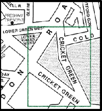
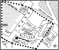
The Cricket Green
The unique character of Mitcham’s Lower Green, the eastern half of which is today known as the Cricket Green, was recognised by its declaration as a Conservation Area by the London Borough of Merton in 1969. The Green was formerly part of the expanse of largely uncultivated heath and woodland – the common ‘waste’ – which formed a substantial part of the parish throughout the Middle Ages.