 MERTON HISTORICAL SOCIETY
 03 Pollards Hill Commonside East and Lonesome
 Mitcham Histories 3
by Eric Montague
Pollards Hill itself – the dominating topographical feature of the district – is beyond the boundary of Mitcham. The Pollards Hill housing estate and the neat roads of inter-war houses extending towards the centre of Mitcham had been until the early 1920s largely farmland, extending to the edge of Mitcham Common and interspersed with hedgerows and clumps of residual woodland. Here and there Victorian villas and old country cottages still survived as links with the past.
Commonside East is a study in its own right, showing how as early as the 17th and 18th centuries desirable sites bordering the open heath had been enclosed for the building of several substantial houses. A change in tempo is discernible from the beginning of the 20th century, and the process of suburbanisation reached its climax with Mitcham’s phenomenal growth in the 1930s.
Closer examination shows the history of the hinterland to be even more interesting, for here a medieval open field system had survived virtually intact until the mid-l9th century before giving way to market gardens, a firework factory and other light industry, gravel extraction, brickworks and chemical works – each making its own contribution to the economic history of the expanding town.
Finally there is the strangely-named hamlet of Lonesome, appearing more as a late-Victorian overspill from Streatham rather than part of the ancient parish of Mitcham, and yet having origins extending so far back in time that the student is still left to speculate on how it all began.
 CONTENTS
- PRELIMINARIES: Geology and land use; Beating the bounds
- LONESOME: Lonesome Farm; The Lonesome Chemical Works; ‘Blake’s Folly’ and Long Thornton
- EASTFIELDS: Eastfields Farm and the Mizen family; James Pain and Sons Ltd. (1872 – 1966)
- COMMONSIDE EAST: The smaller houses between Grove Road and Manor Road; The Cedars, Commonside East; Tamworth Lodge, Commonside East; Tamworth House, Manor Road
- THE FARMS ON COMMONSIDE EAST: Sherwood Farm; Galpins, or New Barns, Farm
- A PERAMBULATION FROM EASTFIELDS TO MEOPHAM ROAD
- URBANISATION: Long Thornton and Pollards Hill (pre-1939); Municipalisation; The building of the post-war Pollards Hill Estate
- THE CHURCHES
APPENDIX 1: Reminiscences of work at James Pain and Sons Ltd
APPENDIX 2: The Cedars, Mitcham Common
MITCHAM HISTORIES: 3
POLLARDS HILL
COMMONSIDE EAST
AND
LONESOME
Extract from a Map of the County of Surrey, by A Bryant, dated 1822-3
MITCHAM HISTORIES: 3
POLLARDS HILL
COMMONSIDE EAST
AND
LONESOME
E N MONTAGUE
MERTON HISTORICAL SOCIETY
POLLARDS HILL, COMMONSIDE EAST AND LONESOME
Published by
MERTON HISTORICAL SOCIETY
in association with
COMMONSIDE COMMUNITY DEVELOPMENT TRUST
2002
© E N Montague 2002
ISBN 1 903899 14 1
Printed by Intype London Ltd
Cover Illustration: detail from a 19th-century engraving entitled,
‘The Fifth of November: Firework Manufactory, Mitcham, Surrey.’
FOREWORD FROM THE COMMONSIDE
COMMUNITY DEVELOPMENT TRUST
We are delighted to be associated with the publication of this book.
The Commonside Community Development Trust has been established
to regenerate Pollards Hill ward, Longthornton ward, and the Eastfields
part of Figges Marsh ward, in the London Borough of Merton.
This area has had its difficulties in recent times and faces a number of
problems, including a sense of isolation and poor transport links.
It is interesting to see today’s problems in historical context. As the
area’s isolation has always been a concern, perhaps it is not surprising
that one of the earliest settlements in the area was known as ‘Lonely
Farm’, which became ‘Lonesome’ and later gave its name to one of the
primary schools in the area.
The Commonside Community Development Trust is especially pleased
to see this book published because it is important to recognise that
communities and their cultural life are key elements in the regeneration
of an area. We need jobs, and transport, and health services, but we
also need the area to have a life, a history, and a future.
The Trust undertakes a wide range of activities, many of which are set
out on its website at www.commonside.net
We encourage you to have a look and become involved in the future of
the Commonside area.
Commonside Community Development Trust
70 South Lodge Avenue
Mitcham
CR4 1LW
Tel: 020 8764 5896
Email: info@commonside.net
Web: www.commonside.net
POLLARDS HILL, COMMONSIDE EAST AND LONESOME
PREFACE
Some readers may consider the title of this book to be a little odd in thatPollards Hill itself – the dominating topographical feature of the district
– is beyond the boundary of Mitcham. The explanation lies in the1950s, when my employment in the local environmental healthdepartment required almost daily visits either to the Borough Council’snew Pollards Hill housing estate or to the neat roads of inter-war housesextending towards the centre of Mitcham. As my interest in local historydeveloped, the landscape over which the hill still provides such a fineviewpoint soon began to intrigue me. I found it sad to think that until
the early 1920s this had been largely farmland, extending to the edgeof Mitcham Common and interspersed with hedgerows and clumps ofresidual woodland. Here and there Victorian villas and old countrycottages still survived as links with the past, and I resolved to discoverwhat I could about them and the transformation which had taken placewithin my own lifetime.
Commonside East soon emerged as a study in its own right, showinghow as early as the 17th and 18th centuries desirable sites borderingthe open heath had been enclosed for the building of several substantialhouses. A change in tempo is discernible from the beginning of the20th century, and the process of suburbanisation reached its climaxwith Mitcham’s phenomenal growth in the 1930s.
Closer examination showed the history of the hinterland to be evenmore interesting, for here a medieval open field system had survivedvirtually intact until the mid-l9th century before giving way to marketgardens, a firework factory and other light industry, gravel extraction,
brickworks and chemical works – each making its own contribution tothe economic history of the expanding town.
Finally there was the strangely-named hamlet of Lonesome, appearingmore as a late-Victorian overspill from Streatham rather than part ofthe ancient parish of Mitcham, and yet having origins extending so farback in time that the student is still left to speculate on how it all began.
In this volume I have sought to bring together these various studies, forthey are best seen as facets of what has become a distinct part ofMitcham. I realise that inevitably much has been glossed over, buthope that my omissions will be forgiven. Such is the rate of change, ofcourse, that within a year or so the text will have become ‘dated’. I can
only draw some comfort from the thought that a starting-point has been
established from which a future student can commence the next version
of the history of Pollards Hill, Commonside East and Lonesome.
E N M August 2002
vii
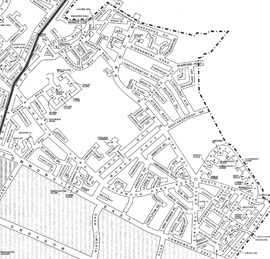
Detail from a modern street map showing the area covered by this book.
Reproduced by permission of Merton Design Unit, London Borough of Merton
POLLARDS HILL, COMMONSIDE EAST AND LONESOME
ACKNOWLEDGEMENTS
The compilation of material for this booklet, particularly in the early
stages of research, would have presented a difficult task had it not been
for the willing assistance I always received from the professional staff
at the Surrey Record Office (as it then was) and local history and
reference librarians at Lambeth, Croydon and Mitcham. Too many to
mention by name, they helped me tremendously, and many I came to
regard as friends. To Dr R C W (‘Ron’) Cox, whose evening lectures I
attended over 40 years ago, I owe a particular debt of gratitude for
firing my enthusiasm for local history. Mr Hutchings (Pain’s Fireworks),
Mr G E T Newland (Smith’s Meters) and the late Gerald Morris
(Mizen’s) provided detail that could only come from long association
with the firms concerned. Fellow historians, such as John Brown and
Graham Gower of the Streatham Society, also provided invaluable
material and comment. Without the care and attention to detail with
which Margaret Carr, Judith Goodman, Peter Hopkins and Tony Scott,
fellow members of Merton Historical Society, read the draft text,
numerous embarrassing slips might well have passed into the printed
version. I owe them all my sincere thanks. To Peter Hopkins credit is
especially due for preparing so professionally the final text and
illustrations for the printers.
Finally, I would like to acknowledge the generous financial help given
by the Commonside Community Development Trust, without which
publication of this book would not have been contemplated by the
Society for some time to come.
E N M
Imperial Measure is used throughout this book.
One acre = 0.4047 hectares. 1 foot = 0.305 metres
CONTENTS
FOREWORD ……………………………………………………………………………………v
PREFACE ………………………………………………………………………………………. vi
ACKNOWLEDGEMENTS ……………………………………………………………. viii
CONTENTS …………………………………………………………………………………… ix
MAPS AND ILLUSTRATIONS ……………………………………………………….x
1. PRELIMINARIES
GEOLOGY AND LAND USE…………………………………………………………1
BEATING THE BOUNDS………………………………………………………………8
2. LONESOME ……………………………………………………………………………….. 11
LONESOME FARM…………………………………………………………………….14
THE LONESOME CHEMICAL WORKS ……………………………………….20
‘BLAKE’S FOLLY’ AND LONG THORNTON……………………………….26
3. EASTFIELDS
EASTFIELDS FARM AND THE MIZEN FAMILY ………………………….35
JAMES PAIN AND SONS LTD., (1872 – 1966) ………………………………..42
4. COMMONSIDE EAST
THE SMALLER HOUSES BETWEEN GROVE ROAD AND
MANOR ROAD …………………………………………………………………….51
THE CEDARS, COMMONSIDE EAST ………………………………………….60
TAMWORTH LODGE, COMMONSIDE EAST ………………………………66
TAMWORTH HOUSE, MANOR ROAD ………………………………………..72
5. THE FARMS ON COMMONSIDE EAST
SHERWOOD FARM ……………………………………………………………………75
GALPINS, OR NEW BARNS, FARM ……………………………………………. 78
6. A PERAMBULATION FROM EASTFIELDS TO MEOPHAM ROAD …89
7. URBANISATION
LONG THORNTON AND POLLARDS HILL (PRE–1939) ……………. 103
MUNICIPALISATION
THE BUILDING OF THE POST-WAR POLLARDS HILL ESTATE … 110
8. THE CHURCHES ………………………………………………………………………. 115
APPENDIX 1
REMINISCENCES OF WORK AT JAMES PAIN AND SONS LTD …. 119
APPENDIX 2
THE CEDARS, MITCHAM COMMON………………………………………..123
NOTES AND REFERENCES ………………………………………………………….. 125
INDEX …………………………………………………………………………………………. 141
POLLARDS HILL, COMMONSIDE EAST AND LONESOME
MAPS AND ILLUSTRATIONS
‘The Fifth of November: Firework Manufactory, Mitcham, Surrey’ … Cover
Extract from a Map of the County of Surrey, by A Bryant, dated 1822-3 … iiDetail from a modern street map showing the area covered by this book . viiNeolithic hand-axe from Lonesome …………………………………………………….. 2
Map showing geology and drainage patterns ………………………………………… 4Map showing the Bounds of Mitcham in 1833 ……………………………………… 9Detail from Edward Stanford’s map of ‘London and its Suburbs’, 1865 …13Lonesome Farm, Mitcham in 1846 …………………………………………………….16
Rowan Road, 1975 …………………………………………………………………………..19
Ebenezer Terrace, Ebenezer Walk, May 1966 ……………………………………..22Marian Road, north side, June 1975……………………………………………………25
Longthornton Road, 1990 …………………………………………………………………27Detail from 25-inch Ordnance Survey map of 1867 ……………………………..29Detail from the 1893-94 Ordnance Survey map …………………………………..31Smith Meters Ltd, Rowan Road SW16, autumn 1988 …………………………..34
Mizen’s House, Grove Road, Mitcham, June 1975 ………………………………37
‘Eastfields Farm’, 7 Grove Road, Mitcham, May 1966…………………………37The Eastfields High School, April 1974 ……………………………………………..41Inside Pain’s firework factory, Eastfields, Mitcham, April 1966…………….49The Croft, Commonside East, December 1972…………………………………….52
Grove Cottage, 183 Commonside East ……………………………………………….54Detail from 25-inch Ordnance Survey map of c.1870 …………………………..58
Detail from sale map of the Watney estate in Mitcham 1864 …………………69Tamworth House, Manor Road ………………………………………………………….72
A cartload of peppermint belonging to John Jakson & Co …………………….82Detail from the court rolls of Biggin and Tamworth 1855……………………..83South Lodge during its time as Tooting Bec Golf Club house………….. 84,85Arthur’s Pond, with the site of New Barns Farm 1971 ………………………….87
The old Eastfields Level Crossing, c.1960 …………………………………………..88
Acacia Road, looking towards Eastfields, April 1972 …………………………..881–8 Tamworth Lane and Eastfields level crossing, July 1974 ………………..9230 Tamworth Lane, May 1966 …………………………………………………………..9357–63 Acacia Road, April 1966 …………………………………………………………94The Horse and Groom public house, 1990…………………………………………..9741/43 and 49/51 Manor Road, April 1966 …………………………………………..9949 and 51 Manor Road, c.1968 ………………………………………………………….99
Rowan Girls’ School ………………………………………………………………………101
Part of a street plan of 1939, from The Official Guide to Mitcham ……….102
Inter-war speculative housing, Galpins Road, May 1976 …………………….108The last of the Arcon ‘pre-fabs’, Middlesex Road, June 1977 …………….. 111Westmorland Square under construction in 1950 ………………………………. 112Wide Way, Pollards Hill Estate, 1974 ………………………………………………. 113St Olave’s Church…………………………………………………………………………..114
Church of the Ascension, Sherwood Park Road, 1990 ……………………….. 118
‘The Fifth of November: Firework Manufactory, Mitcham, Surrey’………120
The westwards view from Pollards Hill, June 1975…………………………….140
Chapter 1
PRELIMINARIES
GEOLOGY AND LAND USE
Alfred Mizen, recalling the Mitcham of his boyhood in the l860s, said
of Pollards Hill “The north and east were devoted to … purely farming
and dairy purposes, a large part of the eastern side being in the
possession of the Watney family, who lived at South Lodge … and
farmed the land from Mitcham Common to the Croydon boundary”.1
The picture Mizen conveys is one of a countryside composed largely
of permanent grassland, which contemporary maps and a few
illustrations show to have been divided by thick hedgerows and muddy
lanes. Other old residents remembered equally vividly the still
unenclosed East Field, nearer to the village centre and geologically
quite distinct from the land of the Watney estate. This open field was a
survival from the Middle Ages, preserving in its unenclosed plots a
form of land tenure which, by the mid-l9th century, was anomalous
and quaintly obsolete. In a court case which arose over disputed rights
to common land, old Henry Tanner gave evidence in 1890 that in his
childhood in the 1840s the “East or Common Fields” were “cultivated
in strips with different crops, chiefly herbs”.2 “The Common fields (now
called East Fields) were a large open space” wrote Emma Bartley, who
could remember the area in the 1850s,3 whilst Robert Masters Chart
recalled how, as late as the 1870s, “Most of the land between Lonesome
and Mitcham village proper was used for the cultivation of herbs, roses
and lavender”.4
The reason for the emphasis on dairy farming and the predominance of
pasture rather than arable land at Watney’s farm lay in the heavy nature
of the soil and the growing demand for fresh milk and dairy produce
from households in the expanding suburbs of London and Croydon.
Pollards Hill, rising 200 feet above sea level, is a spur of the Norwood/
Forest Hill ridge formed from an outcrop of London Clay. Whereas its
summit actually lies just outside the boundary of Mitcham, the lower
slopes extend in a west and south-westerly direction almost to the edge
of Mitcham Common, where the clay becomes overlain with the river
gravels of the Wandle valley. These correspond with the 100 foot, or
POLLARDS HILL, COMMONSIDE EAST AND LONESOME
Neolithic hand-axe from Lonesome (now in the British Museum)
PRELIMINARIES
Taplow, terrace of the Thames, but are probably best regarded more as
the result of alluvial outwash from the downland valleys above Croydon,
from whence sands and gravels were transported northwards by a
precursor of the Wandle during interstadials of the Wolstonian glaciation
and in the early Flandrian period.5 Towards the centre of Mitcham the
clay and terrace gravels are frequently overlain by periglacial deposits
of brickearth, and these, together with the gravels, remained a sufficiently
important resource to be widely exploited by small-scale operators
during the late l9th century. The east fields were located entirely on
well-drained alluvial deposits, topped with loamy brickearth – land
which had obviously long been recognised for its fertility and the ease
with which it could be worked. Only marginally reduced in extent by
enclosure, from the mid-18th century onwards the old common fields
found increasing favour amongst the growers of medicinal and aromatic
herbs for which Mitcham became famous.
The discovery of the only prehistoric implement to be reported from
this part of Mitcham was made whilst the brickearth deposits at
Lonesome were being excavated early in the 20th century. Other
evidence of archaeological significance will inevitably have been lost,
or have passed unrecognised, but in 1905 the British Museum came
into possession of a partly polished flint axe reported to have been
found in a brickfield close by the Streatham border.6 There is now
unfortunately some doubt as to the actual provenance – brickfields
existed at this time in various places, including one at Short Bolstead,
and another to the north of Meopham Road on land belonging to the
Lonesome Chemical Works. The clay and brickearths at Bolstead were
being worked by the mid-19th century, whereas those in Meopham
were dug somewhat later. Nothing else of significance archaeologically
was reported, and both sites are now closed, the pits having been
backfilled and the land redeveloped for industry and housing. The
Lonesome axe head (or hoe) is of unpatinated flint, and is typical of
the Neolithic period. In southern Britain such implements are commonly
associated with land cleared for agriculture and settled during the late
4th and 3rd millennia BC, and at least two other specimens of very
similar form have come from Mitcham, one from the Common, barely
a mile to the south of Lonesome.
POLLARDS HILL, COMMONSIDE EAST AND LONESOME
1234512345123451234512345123456123456123456123456123456123456781234567812345678123456781234567812345678123456781234567812341234
1234KEY
London Clay / gravel interface
Drainage
Woodland on 1847 Tithe Map
Gravel pits
Brickfields
‘Brickearth’ (Moore estate
sale particulars)
The Main Ditch 6’x3’)
The W estern Ditch (3’)
Geology and drainage patterns
superimposed on a modern street map,
reproduced by permission of Merton Design Unit, London Borough of Merton
PRELIMINARIES
The climax vegetational cover in north-east Mitcham is likely to have
been mixed deciduous woodland, probably with a preponderance of
oak on the heavier land, grading to more open woodland with an
admixture of birch and hazel on the better drained soils, or willow and
alder carr on the wet lands. It is far from clear when clearance of the
primaeval ‘wildwood’ in Britain commenced, but recent work by
palaeobotanists and archaeologists indicates that considerable areas of
natural tree cover not only in the fertile river valleys, but also on the
chalk downland, were felled in the Neolithic period. The implication
must be that clearance, followed by hoe-cultivation, particularly of the
brickearths and the well-drained and fertile soils overlying the terrace
gravels in areas like Mitcham, had begun at a very early date. By the
Late Bronze Age, the evidence from many parts of Britain shows
woodland being managed with great sophistication, and it is likely that
even on the less hospitable London Clay by the first millennium BC
clearance was making an impact, and that the resources of the forest
were being exploited. There is widespread evidence for settlement in
Mitcham during the Roman period, and by the 11th century wooded
areas had evidently been reduced to such an extent that the compilers
of the Domesday Survey regarded them of insufficient economic
significance to be recorded.
‘Hunger Hill Wood’ is mentioned in the papers of the Cranmer family
during the 17th century7 and by the late l8th century maps show two
areas of woodland in the Pollards Hill/Lonesome area – ‘Mitcham Wood’
on the slopes of the hill itself, and a smaller wood or spinney to the
south of Rowan Road.8 Until his death in 185l the larger wood, covering
some 28 acres, was the property of James Moore, one of the major
landowners in Mitcham.9 As ‘Lot 77 … The Great or Hunger Hill Wood’,
it was auctioned in 1853 with the rest of his estate, which included the
manor of Biggin and Tamworth. Maps from the latter part of the 19th
century show ‘Mitcham Great Wood’, which the sale particulars
described as “well stocked with Timber and Underwood, and easily
converted into a Game Preserve”,10 to have had the alternative name of
‘Pollardshill Wood’, whilst the spinney was usually described as
‘Mitcham Little Wood’. How far these were ‘natural’ woodlands, it is
impossible to say, and it is hardly likely that either would have been
POLLARDS HILL, COMMONSIDE EAST AND LONESOME
left sufficiently undisturbed to attain a degree of ecological stability,
for both were managed for sporting purposes by the Watney family
until they sold the New Barns estate in 1905.11
Nothing can now be seen of the original woodland cover of this part of
Mitcham. In a few places isolated oaks give a clue as to what must
once have been a familiar hedgerow tree. Equally common, particularly
towards the centre of Mitcham where the gravelly soil would have
been more to its liking, was the common elm. Malcolm, in his
Compendium of Modern Husbandry, published in 1805, describes how
this tree had become a conspicuous feature of the Surrey countryside,
delighting “in a deep loam, or a soil that is of a gravelly tendency; …
more particularly to be seen to the northward of Croydon”. Here, he
told his readers, “there is very fine elm growing spontaneously in the
several hedgerows. … Many of the trees I am alluding to are very large
and handsome, and would cut into scantlings of almost any dimensions”.
He goes on to make an interesting comment on the uses to which elm
wood was then put:
“In the parishes of Lambeth, Streatham and Mitcham, there have
been very large breaks in consequence of the great demand for the
navy, and the several waterworks throughout the kingdom. Those
of Liverpool particularly have, I am informed, been particularly
supplied from the County of Surrey; and when to these we add the
immense consumption for the London Water works, those at Chelsea,
Lambeth and the New River …
“Elm is converted into planks for the navy and for large builders,
into coffin boards, and for carts and waggons, and also cut into
naves for wheels; the lesser trees are purchased by the pipe borers
who are satisfied with them at small sizes.”12
The earliest large scale Ordnance Survey maps13 show that there were
three streams draining the Lonesome/Pollards Hill area – the Norbury
Brook, or Graveney, just over the parish boundary, the Little Graveney
or, as it is now prosaically known by the land drainage engineers, the
‘Main Ditch’; and another un-named brook which formerly ran
alongside Commonside East. All took water from field-side ditches.
The Little Graveney commenced at the foot of Pollards Hill where two
PRELIMINARIES
tributary brooks united in the vicinity of the Pollard Oak public house
(subsequently re-named the Oak and Acorn, and now demolished), at
the northern end of Chestnut Grove. From thence it flowed westwards,
ultimately joining the Graveney north of Figges Marsh. Although the
Little Graveney now runs underground from Pollards Hill in a large
culvert, its course can still be traced by a line of manhole covers along
the wide rear accessway between Greenwood Road and Vale Road,
and then along Robinhood Lane. Here, the clay subsoil and the lack of
fall resulted in the development of marshy conditions, and a century
ago two enclosures to the south, where Robinhood Close was eventually
built, were known as The Bog and Bog Meadow.9 Water-loving birds
such as snipe were obviously common in this wetland environment,
and inspired names like Blake Snipes and Old Snipes applied to fields
bordering the stream on the other side of Manor Road. Here, where the
stream now passes invisibly under the road, a terrace of six houses
called Willow Cottages was built in the late l9th century – the name no
doubt prompted by the trees overhanging the nearby stream. Towards
Eastfields the Little Graveney flowed through osier beds,14 where the
withies sprouting from the cut stools of willow were regularly cropped
by basket-makers. Mitcham Little Wood occupied the north bank and,
given the high water table, the trees here would have been species such
as alder and sallow, with perhaps some birch. Self-seeded specimens
were recolonising the nearby Pain’s firework factory site when it became
derelict in the mid-1960s, showing how quickly the area would revert
to scrub and woodland if left to nature.
Until the end of the Victorian period Pollards Hill Wood survived very
much its l8th century form, but within a few years of the sale of the
Watney estate it had been cleared completely and the land was laid out
as golf links for the Tooting Bec Golf Club.15 The site of the wood is
now occupied by the buildings and grounds of William Morris Middle
School and Tamworth Manor High School. Mitcham Little Wood
survived somewhat longer, but was cleared early this century to create
the Jewish cemetery in Rowan Road.
POLLARDS HILL, COMMONSIDE EAST AND LONESOME
BEATING THE BOUNDS
‘Beating the Bounds’ was a time-honoured custom, the origins of which
lay deep in the past when the necessity was first felt to define a
community’s ancestral territory, and to maintain the boundary marks
long before the invention of maps. We know from local records that in
the 18th and 19th centuries the practice was still taken very seriously
by the churchwardens, overseers and other parish officers, and that their
perambulations, the object of which was to walk, and thereby perpetuate
a memory of, the boundaries of the civil parish, usually took place
during Ascension week in May. In Mitcham bound-beating seems to
have been performed at roughly yearly intervals, and the practice died
out during the 19th century when, with reliable large scale maps
produced by the Ordnance Survey becoming available, it was no longer
necessary to rely on the recollections of old men and ‘marks’ or boundary
stones to ensure that the parish boundaries remained unchanged.
What was possibly the last beating of the bounds of Mitcham parish
occurred in May 1879, four years after the creation of the new parish
of Christchurch to serve the increasing population of Colliers Wood.
By this time the perambulation was conducted as much as an excuse
for a pleasant outing with a touch of nostalgia as to serve the more
serious purposes for which it was originally intended. It is also not
clear whether the perambulation followed the boundaries of the civil
or the ecclesiastical parishes.
The following extract of an account of the beating of the bounds of the
parish of Mitcham from Lonesome to the edge of Mitcham Common is
from a manuscript record made by Edwin Chart, now in the care of the
Local Studies Centre of Merton Libraries. Edwin Chart (1805–1885),
son of John Chart, builder of Mitcham parish church and vestry clerk,
became a surveyor by profession and, in his turn, vestry clerk. He was
28 years of age when, acting on behalf of the squire of Mitcham, William
Simpson, he took part in the perambulation one May morning in 1833.
PRELIMINARIES
end of Greyhound Lane
the junction ofthe parishes of
Lonesome
Streatham
Croydonand Mitcham
Oak
Pollard in
Copse
Mr
Moore’s
Wood
ByardsCroft
Boundary points and features mentioned in Edwin Chart’s account of
Beating the Bounds of Mitcham in 1833
superimposed on a modern street map,
reproduced by permission of Merton Design Unit, London Borough of Merton
POLLARDS HILL, COMMONSIDE EAST AND LONESOME
EXTRACT FROM AN ACCOUNT OF THE ‘PERAMBULATION OF THE
BOUNDARY LINE OF THE PARISH OF MITCHAM IN THE COUNTY
OF SURREY, ON THURSDAY 16TH MAY 1833’ BY EDWIN CHART.
(Proceeding in a clockwise direction from Tooting):
“ … to Bridge1 on Streatham Lane, went under Bridge following stream,2,
cut a X in Oak Tree on Bank, another on a small oak corner of Biggin
Field,3 leave stream at corner of 2nd. field where there is a X cut in the
large Roots of an old Elm on the Bank. Then take the ditch in a straight line
under hedge in a Westerley direction go to angle of hedge then turn Right
about 30 Yards then through hedge on left along a hedgerow to Oak Pollard
mark’d X Turn to Left down Blind Lane4 which continues to end of
Greyhound Lane. (Here we adjourned to Muphams5 and partook of an
excellent collation under the superintendance of Mr Weston Overseer)6
Continue Lane to Lonesome, to Gate Post of Field cut a X in it, and keep
straight forward through Dalgleish’s Land to an Oak Pollard standing about
5 Yards beyond Kelly’s7 Field. thence S.W. to Oak Pollard with X cut in it
which stands upon the junction of the parishes of Streatham Croydon and
Mitcham.8 follow hedge of Kelly’s Field, cut a X in Oak Pollard, and
continue to Oak Pollard in Copse,9 in which Mr. Bridger10 cut a X and was
Bumped, continue ditch across end of Mr. Moore’s Wood11 at foot of
Pollards Hill to Bridle Gate. (here Mr. Weston was bumped) thence across
top of field occupied by Back, and cross top of Byards Croft12 to young
Oak Tree in corner of which cut a X (Lockett was here bumped against the
drum head) Then turn right and follow the extreme boundary of Mr. Watney’s
Farm13 occupied by Mr. J. Arthur, in which we cut X’s in several trees, to
corner14 of Waddon Marsh where cut a X in small elm Tree. Turn to Right
under hedge to Boundary Post M P on corner of Common. Follow hedge
of Waddon Marsh …”
Chapter 2
LONESOME
Until the construction of the London, Brighton and South Coast Railway
Company’s line from Streatham to Mitcham Junction in 1868, the hamlet
of Lonesome which, as the name implies, was the most isolated part of
the parish of Mitcham, was reached by lanes leading off the road from
Mitcham to Streatham. The remote position of the hamlet is shown
very clearly in maps in the 1860s, for instance, by Stanford, and the
lanes are marked quite prominently in the earliest detailed map we have
of Mitcham, produced to illustrate Edwards’ Companion from London
to Brighthelmston, published in about 1801. The most northerly, a ‘green
lane’, commenced at the point where today Streatham Road takes a
slight bend to the north opposite Uckfield Close. Two other parallel
routes, Lock’s Lane and Sandy Lane, led to Lonesome only indirectly,
first leading to the east common field, and thence by footpaths and
bridle tracks in a generally north-easterly direction through various
meadows and enclosures. Beyond Lonesome, Greyhound Lane led to
Lower Streatham and Streatham Common.
Like the other two lanes, the first and more northerly of the three was
almost certainly of considerable antiquity, perhaps dating from the period
in the Middle Ages when Merton Priory held an estate extending from
north Mitcham into Streatham (see p.12). The lane from what we now
know as Streatham Road gave its name to an enclosure, Green Lane
Field, roughly on the site of the modern Mitcham Industrial Estate, and
except for a short length which survives as Bolstead Road has now
disappeared. It would seem that by the mid-l860s this route was less
used than the more southerly Sandy Lane, for the railway company
obviously felt under no obligation to provide a footbridge when planning
their line to Mitcham Junction. The reason was possibly the tendency
for the lane to become very muddy in winter, for it ran slightly to the
north of the Little Graveney flowing from Pollards Hill, and at the foot
of a gentle rise in the land where the London Clay came near the surface,
topped with gravel.1 Surface and sub-soil water draining towards the
brook, particularly in winter, is likely to have rendered the lane at times
impassable, and Sandy Lane would certainly have offered a better
alternative.
POLLARDS HILL, COMMONSIDE EAST AND LONESOME
When organising the census of 1841 the local registrar included
Lonesome and Lonesome Farm in the enumeration district comprising
that part of Upper Mitcham lying to the east of the road to Streatham.
The completion of the railway line in 1868, by creating a physical barrier
to the east-west movement of animals and vehicles north of the level
crossing at the end of Lock’s Lane, changed this orientation dramatically,
and Lonesome became even more isolated.
Sandy Lane, overhung with trees and, until surfaced early in the 20th
century, also wet and muddy for much of the year, connected with a
bridle path bordering the common field. Those on foot could cut across
the field, crops permitting, or follow the path by turning towards the
north-east. In the mid-19th century this led to the brook, beyond which
one could take a path diagonally to the right across a watermeadow,
following what in later years was adopted as the line of Grove Road.
The two meadows at this point, situated on the north bank of the
watercourse, were probably liable to flood. Known as the first and second
Shore Meadows (‘shore’ meaning bank), they were tenanted by James
Weston of Pound Farm, Upper Mitcham.2 The site of the farmstead is
just north of Mitcham Library, and the old bridle path leading to the
East Field still exists. The two meadows were eventually to be acquired
by the Mitcham Local School Board to provide a site for Lonesome
Mixed School, which opened in l903.3
After crossing the Little Graveney the way to Lonesome, still more a
bridle path than a lane, followed the side balk or field bank between the
furlongs of Short Bolstead to the left and Long Bolstead to the right,
turned for a short distance along a way-balk or headland, and then
continued north-eastwards again along another balk on the western edge
of a second furlong called Meopham. At the head of the balk, destined
to become Ebenezer Walk, a lane came in from the left and a footpath
to the right (which still survives in part) led alongside a meadow and
by a small wood to Lonesome Farm itself. A tree-lined lane ahead (now
Leonard Road) continued to the parish boundary and Greyhound Lane.
The 25-inch (1:2500) Ordnance Survey map of 1865 indicates a single
long building where the paths met, but there is nothing to indicate its
function.
LONESOME
Recalling the Lonesome area as it was in her childhood, Emma Bartley
confirmed that in this part of the parish in the 1850s there were no
buildings of any kind, except “two or three detached low cottages”.4
James Drewett, describing the district as he remembered it perhaps ten
years later, said that “there were no houses in the East fields before the
advent of the railway except a few at the end of Lock’s Lane, Temple’s
Cottage, the horse slaughterers, and chemical works and an old farmstead
at Lonesome”.5 Robert M Chart similarly described it as consisting in
the 1860s of “a chemical factory, a horse slaughterer’s and a few
tumbledown cottages”.6
LonesomeFarm
Detail from sheet 22 of Edward Stanford’s map of ‘London and its Suburbs’,
published in 1865
POLLARDS HILL, COMMONSIDE EAST AND LONESOME
LONESOME FARM
Tantalisingly, very little is known of the early history of Lonesome
Farm. In 1086, at the time of the Domesday Survey, a small part of the
estate in Mitcham held by Bishop Odo, assessed as half a hide and
therefore about 60 acres in extent, was occupied by Ansgot, who also
held Streatham as a tenant of the bishop.1 It would seem that Odo’s
estate subsequently passed into the hands of Merton Priory which, until
the Dissolution in 1538, also owned lands extending over the border
from north Mitcham into Streatham. The possibility is, therefore, that a
settlement which evolved into the farmstead of Lonesome was already
in existence by the 11th century, but of course this cannot be proved
without an archaeological assessment. The Ministers Accounts of 1538
(dealing with the Biggin and Tamworth estate of the dissolved Merton
Priory) contain references to crofts held by Pratt, which may have been
at Lonesome.
The tithe commutation register of 1846 shows that the land worked
from Lonesome Farm was titheable, with the great tithes, or rights to
hay, being due to William Simpson, rector and lord of the manor of
Mitcham, and the tithes of wood and corn to Daniel Watney. The
residual, or little tithes, were payable to the vicar. The implication is
that the farm was not a recent creation formed by reclaiming erstwhile
‘waste’, but had been of acknowledged economic value, as pasture,
arable or woodland, since the early Middle Ages. Drewett’s recollection
of Lonesome farmhouse being old has to be a little suspect, since he
was only a boy at the time.2 Nevertheless, ‘old’ in the 1860s conveys
the impression of a building dating from at least the 18th century, and
possibly much earlier. In Surrey History Centre there is a marriage
settlement of 1659 mentioning Mepham (sic) and Eastfields.3 There
are also extant records of houses and lands in Eastfields and Long and
Short Bolstead covering the period 1653 to 1797. In the same collection
of deeds one finds mention of land in the common field being fenced
and hedged, and of an orchard planted in 1687.4 Whether these references
relate to activities centred on Lonesome one cannot say, but it does
seem a possibility.
LONESOME
No buildings at Lonesome are shown in the first edition Ordnance
Survey map published in 1816 and surveyed over the preceding two
decades or so. The scale, however, is small, and the lack of evidence
therefore inconclusive. It is thus intriguing to find a ‘Lonely House’
shown in Greenwood’s map of 1823 in the position known to have
been the site of Lonesome Farm only some 20 years later. In the absence
of house names or addresses in the 1841 census records, it is difficult,
if not impossible, to identify an entry relating to either Lonely House
or Lonesome Farm as such, and thereby to ascertain the names of the
occupiers. The Mitcham poor rate books, the earliest of which date
from the 1750s, contain no entries identifiable with Lonesome, although
we can be sure the parish officers would not have overlooked a property
from which a rate could be collected.5 For similar reasons the land tax
records, so helpful in tracing ownership and occupation of larger
properties from 1831 back to 1780, do not readily yield any useful
information. As we have seen, the farm was certainly recognised as
established enough to be a landmark in the census enumerator’s district
of 184l, and one can only hope that research may yet solve the riddle. A
tentative and provisional conclusion to explain the absence of record
could be that by the mid-18th century Lonesome Farm had become a
very run-down concern, with the house itself left to ‘rack and ruin’,
and perhaps for the most part standing vacant.
By the mid-1840s the position becomes much clearer, thanks to the
register and accompanying map produced for the tithe commissioners
in 1846/7. From these records one can see that the area covered today
by the houses and flats of Rowan Crescent and Rowan Close was the
centre of the farmstead, and that the farm lands extended over some 94
acres in the north-east corner of the parish of Mitcham. The house,
together with its sheds and stables, rickyard, garden and orchard,
occupied a little over an acre and a half of land fronting the lane leading
to Lower Streatham. This is now Rowan Road, and the actual site of
the farmhouse and its associated outbuildings is covered by the flats
numbered 87 to 105 Rowan Road. Samuel Martin, the occupier in the
1840s, is not mentioned in the census return for 1841, nor is there any
mention of him or the farm in the contemporary Mitcham directories.
POLLARDS HILL, COMMONSIDE EAST AND LONESOME
LONESOME
FARM
TheFive
Fourteen
Acres
LONG THORNTON
THE EAST
FIELD
WOOD
MITCHAM
GREAT
Parish Boundaries
WOOD
The Six Acres and Half
The
Five
Acres
(meadow)Meadow
back of
House
House,
Farm
Y ard,
Buildings,
Garden,
Rickyard,
Orchard,
etc
Lonesome Farm, Mitcham, in 1846, based on the Ordnance Survey First Edition
map, with further information added from the Tithe Apportionment
LONESOME
Whereas the early history of Lonesome Farm thus remains unclear, the
names of several of the fields owned by Martin in the parish of Mitcham
in 1846, as well as their location and actual shape, offer some clues as
to their origins. To the north of Meopham Road, which had its beginnings
as one of the headlands between the furlongs in the open fields, Martin
owned two separate strips or selions described as being “in Meopham”.
This particular furlong was one of a group of similar fields, situated
about as far as one could get from Mitcham village centre and still
remain in the parish. The derivation and significance of ‘Meopham’ is
unknown. It suggests some connection with the village in Kent, in which
case the most likely explanation is that the name started as a rather
weak village joke. A piece of land on the southern side of the headland
was known as Top of Newfoundland, another name which may have
been coined to emphasise that it was only reached after a long treck
from the village where some of the labourers would have lived.
Elsewhere in Mitcham there are other remotely situated fields named
America and Botany Bay Acre.
The pattern of the strip holdings in Meopham was typically medieval,
and for centuries the land would have been farmed in common by the
owners or their tenants, following a time-honoured custom of crop
rotation with intervening years of fallow. In Mitcham there was no
statutory enclosure of the common fields but, as we have seen, there is
mention of fencing and hedging of land in the east field taking place in
1687, and also of the creation of an orchard. By Martin’s time many of
the narrow strips had been combined to form more easily managed
holdings. This trend can be detected in the shape and tenure of several
fields to the south of Meopham Road in the mid-1840s, and within
about 30 years the old open field system had gone, to be replaced by an
enclosed landscape of hedged fields and market gardens.
Grouped around the farmstead at Lonesome were four enclosures kept
permanently under grass, providing pasturage for horses and other farm
stock. One, a meadow of L-shaped plan enclosing the farm yard and
buildings, is now covered by the houses of Rowan Crescent. To the
south of the farmhouse was The Little Field fronting Meopham Road,
and the Three Acres Meadow at the corner of Meopham and Rowan
Roads. A fourth meadow, now the site of Lilian Road, Marian Road
POLLARDS HILL, COMMONSIDE EAST AND LONESOME
and Greyhound Terrace, lay to the north. In their compact arrangement
around the farmhouse and yard these meadows resemble the ‘infields’
often to be found around homesteads of known medieval origin.
Ten enclosures owned by Martin lay between the present Longthornton
Road and the Streatham boundary, and are now covered by the houses
and gardens in Windermere, Chilmark and Hassocks Roads, the grounds
of Stanford Middle School, and the former Westminster Bank Sports
Club. One, a long strip of arable land extending eastwards from Rowan
Road, was to provide land for the future factory of Smith Meters Ltd.,
and had the picturesque name of The Mermaid Field, or The Long Six
Acres – an obvious allusion to its shape. In the main the enclosures to
the north were of a regular, rectangular shape, looking very much like
assarts, created from former woodland or waste during a period of
expansion. Their names, The Five Acres, The Nine Acres, The Six
Acres and The Fourteen Acres, speak of unromantic practicality, and
support this impression of planned enclosure. There were periods of
general prosperity and improvement in farming in the 13th and early
14th centuries, and again during the Tudor period when such activity
might have taken place, but of course we have no real evidence of what
actually happened at Lonesome and when.
An enclosure called Bennett’s Wood (which became the site of the bank’s
clubhouse) had only recently been converted from meadow to arable in
1846, and three others, also formerly meadow, had been put under the
plough a short time before. One can speculate as to the significance of
these changes, which are not noticeable to any extent elsewhere in
Mitcham, but of course cannot come to any very definite conclusion. It
is possible that Martin, who also farmed at Mount Nod and elsewhere
in Streatham, was finding the Mitcham farm unprofitable and, by
reducing the amount of pasture and placing greater emphasis on crops
raised on the arable, was seeking a better financial return.
The 1851 census return for Mitcham, more detailed than that of a decade
earlier, mentions ‘Lonesome Farm house’. It was occupied by 50-year-
old Thomas Sanders, described as an agricultural labourer, together
with his wife Mary, who was endeavouring to make ends meet as a
laundress, and two girls styled as ‘house servants’. In the vicinity there
LONESOME
were two empty cottages, and also three ‘Lonesome Farm cottages’,
each tenanted by labourers. Finally, another property, Lonesome Farm,
described as a 100-acre farm, but employing only one man and a boy,
is classified as ‘non-residential’. Far from conveying the impression of
a flourishing agricultural community, this suggests Lonesome Farm
was a very run-down concern, barely viable and providing a poor living
for those working its land. This was, of course, precisely what Emma
Bartley, James Drewett and Robert Chart remembered.
Changes were in the offing, for at a meeting of Mitcham vestry in 1853
it was reported that new factory premises had been “lately erected at
Lonesome Farm”.6 The ratepayer, which is what concerned the Vestry
most, was still Samuel Martin, but this probably did not remain the
situation for long. The 1862 Post Office directory lists for the first and
only time a George Downham, a farmer, at Lonesome. Downham’s
occupancy of the farm premises thus can only have been a short-lived
phase, and the new 25-inch Ordnance Survey map of 1865 shows in
some detail what is described as the Lonesome Chemical Works,
occupying the whole of the site of the former farmyard. Nothing
remained resembling the farmhouse shown on the tithe map 20 years
previously, and the enigmatic Lonely House seems to have been
demolished to make way for the new industrial complex.
Rowan Road, 1975. The newer houses to the left occupy the site of Lonesome Farm.
POLLARDS HILL, COMMONSIDE EAST AND LONESOME
THE LONESOME CHEMICAL WORKS
Described in the the Mitcham vestry minutes of 1853 as “the new factory
lately erected at Lonesome Farm”,1 Thomas Forster’s India rubber and
chemical works were listed in the Post Office directory for 1855, but,
disconcertingly for the local history researcher, neither he nor the
Lonesome Works receive mention in the 1862 edition. One has to assume
that this was an oversight, for the land certainly continued to be occupied
by a chemical works, with which the Forster family were intimately
connected, for the next 40 years.2
Charles Macintosh had invented the waterproofing of cloth with a
solution of rubber in naphtha in 1823, and the next quarter of a century
was a period of continuous improvement and expansion, both in the
manufacture of waterproofed fabrics using Macintosh’s process, and in
the utilisation of rubber generally. In about 1855 a chemical manufactory,
which had been established in the disused parish workhouse on Mitcham
Common, ceased production and the premises were taken over by the
partnership of Hooper and Fry, who were engaged in the manufacture
of India rubber groundsheets and waterproof clothing for the use of the
troops in the Crimea. The war ended the following year, and William
Hooper, Fry apparently having left the partnership, expanded the works
and established Hooper’s Telegraph and India Rubber Company, which
flourished at the works on Commonside East for a further 30 years.3
In the neighbouring parish of Streatham, Thomas Forster had been
manufacturing India rubber waterproofed goods since about 1838 at
the premises of a former silk mill overlooking the Common.4 A man of
considerable innovative ability, he was granted two letters patent in
1844 to protect his inventions for improving the manufacture of rubber
compositions and coating compounds, and the production of elastic
fabric and machine belting.5 He is also credited with originating sponge
rubber, patented in 1869, and the making of seamless rubber gloves for
surgical and household use. In 1857 the Streatham Common factory
was purchased by Peter Brussey Cow (the founder of the firm of P B
Cow Ltd) who had been manufacturing India rubber goods at Cheapside
for the previous nine years. Thomas Forster was appointed works
manager of Cow’s new Streatham works, and in 1868 was taken into
LONESOME
partnership. His home was at Sparrow Hall, Streatham, where he died
in 1880 at the age of 72. Forster’s eldest son, an analytical chemist, was
to become a partner in the firm of Forster and Gregory, manufacturing
chemists at Lonesome, and the youngest son, Emerson, who died in
1895 at Sparrow Hall, was associated with the Lonesome Chemical
Works for some 30 years.2
The choice of one of the most remote and unpopulated parts of Mitcham
in the l850s for the siting of a rubber or chemical works was probably
deliberate for, apart from the proximity of the Balham to Croydon
railway and potential industrial users for its products, what almost
certainly were highly offensive processes were thus well-distanced from
the nearest houses of any consequence. Naphtha is, of course, a product
of the distillation of coal, and retorts of this period, when the necessary
bituminous coal was cheap, tended to be grossly inefficient, emitting
clouds of sulphurous smoke when discharged, and producing quantities
of offensive gas liquors. Coal gas would have been produced during
the course of distillation, and a gas holder is shown on the 1865 Ordnance
Survey map, close to the Rowan Road frontage of the Lonesome Works.
There is no evidence of any attempt to supply gas for domestic use in
the neighbourhood, but it is interesting to speculate that had Forster’s
Lonesome Works not been located so far from the centre of Mitcham,
he might have been a potential competitor with the Mitcham Gas Light
and Coke Company, founded in Western Road in 1848. Gas coke,
another by-product, would have been a saleable commodity but, here
again, there is no record of its being sold as cheap fuel in the locality.
The works did, however, create a demand for labour, and may have
been the stimulus to the building of several streets of artisans’ dwellings
in the immediate vicinity towards the end of the century.
Concurrently with the developments at Lonesome Farm in the l850s
and ’60s, other changes were occurring in the neighbourhood. James
Briggs, a market gardener, took over Pound Farm from James Weston,
and an arable field of a little over seven acres at Lonesome, formerly
rented by Weston, became a brickfield. By 1853 part of Meopham,
together with Samuel Martin’s Two Acre Field and the Little Field to
the south of the old farmhouse, were also being exploited for their deposits
of brickearth.6 Smoke and fumes from the clamps (London stock bricks
POLLARDS HILL, COMMONSIDE EAST AND LONESOME
at this time contained a generous admixture of domestic refuse and ashes
to aid the firing process) added to the smells of the piggeries, knacker’s
yard and chemical works to create a pot-pourri of odours which, wafted
towards Lower Streatham when the wind was from the south-west, must
have pervaded the shallow valley of the Graveney like a miasma. Once
brickmaking had ceased in the early 20th century the pits were backfilled
with rubbish and eventually a substantial part of the land was
reclaimed for housing development. Today a remnant of Briggs’ land
survives as the Oakleigh Way recreation ground.
Ebenezer Terrace, Ebenezer Walk, May 1966
Ebenezer Terrace, marked on late 19th-century maps as Allen’s Cottages,
was a row of 16 ‘two up and two down’ dwellings built in about 1870,
presumably either for men employed in the chemical works or for
agricultural workers. The landlord was J F Allen, who owned the nearby
Second Shore Meadow in 18536 and, presumably, other land in the vicinity.
The cottages were entered direct from the roadway, and stood on what
had been a strip-holding in Meopham. The narrow nature of the plot
dictated the form of the development and, since the land tapered, the
southernmost cottage was smaller than the rest. In the 1940s and ’50s
these dwellings were still owned by the Allen family, represented by the
LONESOME
Misses Allen, who lived at Sherborne House, Tamworth Lane, near the
Eastfields level crossing. To the north of Ebenezer Terrace were piggeries
and an unsightly conglomeration of lock-up garages and sheds, some of
the latter dating back to the 1860s. All were cleared away in the 1970s,
and the site used for new housing development.
Nos. 1–15 Meopham Road, a row of late-19th century terraced villas the
other side of Meopham furlong from Ebenezer Walk, were built on what
had been known as Fox’s Meadow, rented by Samuel Martin of Lonesome
Farm from Henry James Scriven in 1846.7 An isolated house standing
here in the 1860s was demolished to make way for the terrace at the rear
of which, until well after the end of the last war, there was yet another
piggery. Like its neighbours off Ebenezer Walk this prospered during the
years of food rationing, and provided what was one of the last links with
Lonesome’s rural past.
The sale to a Henry Merceron of the six and a half acre field with a farm
cottage and buildings at the southern end of Greyhound Lane, also once
part of Martin’s Lonesome Farm, took place in 1874.8 If speculative
building had been the purchaser’s intention, development occurred only
very slowly, a few small houses on the northern side of Marian Road and
others in Lilian and Leonard Roads being the first to be completed.9 Folk
memories recall the Lonesome neighbourhood in the 1880s and 1890s as
occupied by rough and dubious characters, and to be avoided if at all
possible.10 The somewhat sparse entries for the locality in the
contemporary directories are consistent with its squalid reputation, listing
chemical works, knacker’s yard and piggeries. There was a dairyman in
a small way of business, and a beer shop in Greyhound Terrace, whilst
the residents were predominantly agricultural labourers, with a few factory
workers. By 1875, to bring ‘a little light in a dark corner’, Mitcham parish
church’s Lonesome mission room and Sunday school had appeared in
Leonard Road. It was soon to be joined by the ‘tin tabernacle’ of the
Baptists at the junction of Marian and Lilian Roads.11 The Salvation Army
Hall, however, did not acquire land for its headquarters in Leonard Road
until after the war.
No photographs of Lonesome Farm, or of the chemical works, seem to
have survived, and their appearance is unknown. At some time,
POLLARDS HILL, COMMONSIDE EAST AND LONESOME
presumably towards the end of the 19th century, the Meopham brick
fields were reclaimed, providing a site for a new gas-mantle factory. The
revised Ordnance Survey map of 1934 shows the works at their maximum
expansion, extending from Lilian Road to Meopham Road, and east to
Rowan Road. Also by 1934 the Three Acre Meadow of Lonesome Farm
at the corner of Meopham and Rowan Roads had been developed for
shops and housing, and one half of the future Rowan Crescent had been
marked out. The decline in popularity of town gas for domestic lighting
was by this time having a serious effect on the demand for incandescent
mantles, and by 1936 the western part of the site had been taken over by
Beck and Company (Meters) Ltd and the eastern portion, formerly
occupied by the Lonesome Chemical Works, became available for
completion of the Rowan Crescent housing estate. Building was
temporarily suspended at the outbreak of war in l939, and was not
completed until the l950s. Some of the last dwellings to be erected,
numbered 87–105, Rowan Road, occupy the actual site of the old
farmhouse and yard.
In August 1970, a century after they had been built, Nos. 1–19a Greyhound
Terrace were demolished. The 38 flats, owned by a Mr Towell and
managed for many years by G D Brown, a builder with an office at 24
Greyhound Terrace, were in a very dilapidated state when they were
purchased by Merton Council with a view to refurbishment. Escalating
building costs, and the extent of the work required, however, obliged the
council to abandon the original proposals, and in April 1979 the local
press announced that the decision had been reached to demolish, and for
the site of the terrace to be used for 18 new homes under the authority’s
‘build-for-sale’ scheme. Demolition commenced that summer with Cllr
Harry Cowd (a head teacher and chairman of the Council’s housing
committee) wielding a sledge-hammer for the benefit of the assembled
press and dignitaries. The new houses, a mix of two- and three-bedroom
properties built by Thomas McInerney and Sons, were ready for
occupation in 1980, with priority for purchasing being given to Council
tenants and others on the housing waiting list.
Opposite the site of the chemical works a substantial part of the Rowan
Road frontage of the Five Acres meadow, with much of the Nine Acres
field to the rear, became the Manor Works of Marco’s Refrigerators Ltd
LONESOME
during the inter-war years. The rest of the Nine Acres was, for a while, a
football ground complete with stand, but this land was taken for the Byards
Croft and Oxtoby Way estate of maisonettes shortly before the declaration
of war against Germany in 1939. A small part of the Five Acres remained
as open ground in the occupation of Stirling Nurseries until the 1980s. It
was then acquired for the building of Stirling Close, a small cul-de-sac
development of houses and a doctors’ surgery, entered from Windermere
Road. The Manor Works, empty by the 1980s, was still standing 15 years
later, with its windows boarded and a lush growth of weeds sprouting
through cracks in the factory yard.
The tradition of industry at Lonesome, started by Forster in the 1850s,
was continued into the 1960s by Beck and Company, meter engineers
and manufacturers of petrol pumps. The works entrance was at the
southern end of Lilian Road and, such is the extraordinary persistence of
land boundaries, the area covered by the buildings of Beck and Co., (and
once occupied by the gas mantle factory) was still virtually that of
Meopham, the old furlong in the medieval open field. By 1987 the
industrial premises had gone completely, and redevelopment for residential
use was proceeding with the erection of estates by Laing and Super Homes
of Milton Keynes in a new cul-de-sac to be known as Veronica Gardens.
Marian Road, north side, June 1975
POLLARDS HILL, COMMONSIDE EAST AND LONESOME
‘BLAKE’S FOLLY’ AND LONG THORNTON
It now remains to recount one further, and quite extraordinary, episode in
the history of Lonesome – that of the abortive attempt to initiate the
development of the area as a select Victorian suburb.
Two parcels of land described as ‘in Long Thornton’, and containing a
little over 1.5 acres and 3 acres respectively, are shown on the Mitcham
tithe map of 1847 to the east of what we now know as Rowan Road.
Long and narrow in plan, they might have originated as medieval strip
holdings, and if so represent, with Meopham, some of the most northerly
extensions of the common field system of the parish. The tithe register of
1846 records parcel 749 (the northern and smaller of the two) to have
been owned by Captain Charles Hallowell Carew of Beddington and
occupied by James Moore, whilst 748 was both owned and occupied by
Moore.1 With a sub-soil of London Clay overlain with loam, both holdings
were under grass.
James Moore, principal of the firm of Potter and Moore, the famous
growers of medicinal herbs and distillers of essential oils, had a large
estate in Mitcham, its constituent parts scattered throughout the parish.
Moore died in 1851, and his estate was offered for sale by auction in
August 1853. The Long Thornton holding (Lot 73 in the sale particulars)
is shown on the plan prepared by the auctioneers, Crawters, as abutting
on the north a parcel of land owned by C H Carew Esq.2 The outcome of
the sale is not known, but it is evident from its subsequent history that
Lot 73 was soon to pass into the ownership of a man called Blake. Captain
Charles Hallowell Carew had died in 1849, and was succeeded by his
son, Charles Hallowell Hallowell Carew, a spendthrift and a gambler
against whom bankruptcy proceedings were instituted in 1857.3 The
family estate was in the process of being broken up and sold throughout
the 1850s, and in all probability the Carew portion of Long Thornton
came on the market at this time, to be acquired by Blake.
Blake, referred to in a press account some 50 years later as ‘Squire Blake’4
was not a Mitcham man. Although his identity has not been definitely
established, there are good grounds for believing he was Charles Blake,
landowner and property developer, principally in the West Barnes area
of what became Raynes Park. He lived at Motspur Park from the mid
LONESOME
1850s onwards, firstly at Blue House Farm, and then in a larger house,
The Rookery, which he built for himself. By profession Blake was a
solicitor, with a practice in the City. He was actively (but not always
successfully) involved in railway promotion in association with Richard
Garth of Morden, and would have been well aware of the big increase in
the value of the Long Thornton land once the London, Brighton and
South Coast Railway Company’s Greyhound Lane station was opened
on their Balham to Croydon line, only half a mile away, in 1862.5 In the
Raynes Park area, Charles Blake was master of the local stag hounds,
and very much the aspiring country gentleman. He died in 1897, and was
survived for many years by his much younger second wife, on whose
behalf the estate was administered by trustees, until at least the outbreak
of the first World War.6
Whether or not ‘Squire’ Blake at Lonesome and Charles Blake of West
Barnes were the same person, the owner of Long Thornton was certainly
dabbling in property speculation, as is demonstrated by the Ordnance
Survey maps of 1865 and 1867, which show eight houses to have been
erected, either side of a newly constructed roadway of generous width
extending eastwards from what is the modern Rowan Road to the present-
day Northborough Road. The map of 1894 shows a further two houses to
have been built on the southern side of the road in the intervening years,
Longthornton Road, 1990 (note the width of the road)
POLLARDS HILL, COMMONSIDE EAST AND LONESOME
making ten in all. Illustrations in The Morning Leader of 22 July 1901
and a roughly contemporary article in the Daily Mirror portray these
houses as substantial, two-storied six-roomed detached villas, each with
a columned front entrance porch and a generous garden. The low pitched
roofs were obviously of slate, the brickwork probably of yellow stocks,
and the window and door openings were surrounded by stucco architraves.
The style is still familiar in South London, and is datable to the 1850s or
’60s. The development was clearly conceived with middle class residents
in mind, and the venture was quite likely to have been encouraged by the
proximity of the new railway station. Situated in what was still pleasant
open countryside, with tracts of sheltering woodland and distant views
of the Surrey Downs to the south, the new houses should have found a
ready sale.
Remarkably, and for reasons which are by no means clear although various
theories can be advanced, the houses were never finished, work on them
ceasing after completion of the main structure and roofing, but before the
internal carpentry and joinery work had commenced. From the evidence
of the maps there seem to have been at least two phases of building between
1860 and 1890. It is said that for a time the unfinished houses were kept
in repair and the site fenced with iron railings to prevent trespass, but as
the years passed the gardens were increasingly overgrown with weeds
and brambles, whilst the tree-lined road eventually became completely
grassed over. Across the parish border housing development was
proceeding steadily. Greyhound Lane station was re-named Streatham
Common in 1875, and three years later Norbury station was opened.5
The first wooden station was replaced by the present brick building in
1902, but in 1905, when housing development could be seen proceeding
apace on the slopes of nearby Pollards Hill, the freehold villas on the
Long Thornton building estate were still empty and beginning to collapse
through decay and neglect. A notice board proclaimed that the land was
offered on long building leases at easy terms, and directed enquirers to
the estate office at 6 Cheshunt Road, West Norwood.7 Apparently no-
one was sufficiently interested to pursue matters to a satisfactory
conclusion, and the area acquired a notoriety as a ‘ghost town’, from
time to time attracting the curiosity and imagination of columnists in
both national and local press.8
LONESOME
Detail from 25-inch Ordnance Survey map of 1867, reduced in scale, showing Blake’s development (bottom centre)
and the Lonesome Chemical Works (top centre)
POLLARDS HILL, COMMONSIDE EAST AND LONESOME
Two possible explanations for the failure of the enterprise occur to the
writer. As we have seen, in 1853 it was reported to Mitcham Vestry that
a new factory, which was to become Thomas Forster’s Lonesome
Chemical Works, had been erected at Lonesome Farm.9 This was on the
opposite side of the road to Long Thornton, only a little over 100 yards
from where the nearest of the new villas were to be built. It was Blake’s
misfortune to have purchased the land only recently with a new housing
estate in mind, and a clash of interests was as inevitable as it was
unforeseen. The exact sequence of events is not known, but the Ordnance
Survey map shows that by 1867 a small ‘gasometer’ had been erected at
the works, on the roadside frontage opposite the entrance to the new
estate road, and with it there must have been the coke ovens and other
unsightly paraphernalia of what by this time amounted to an embryo gas
works. The Lonesome Chemical Works prospered, and the premises had
expanded considerably by the time the next edition of the 25-inch
Ordnance Survey map was published in the 1890s. Contemporary
accounts refer to a smoking chimney; there was often nuisance from
smells as well. The reaction the presence of such works would have
engendered in those who might otherwise have contemplated removal to
the rural delights of Long Thornton is not hard to imagine.
The establishment of Forster’s chemical works must thus have provided
the initial, serious set-back to Blake’s aspirations. It certainly could not
have occurred at a more unfortunate time, for a period of financial
difficulty was approaching for many who were speculating in house
property. The late 1870s and ’80s were a decade of prolonged depression,
and in the crisis years of 1879 and 1886 unemployment was to rise as
high as 12%. Profits from industry still grew during these years, but Blake’s
houses were probably too small, and certainly too close to the chemical
factory, to be of interest to the more wealthy manufacturers and, for those
whose livelihood depended on retail trade or agriculture, times were
extremely hard. The effects of the depression can be seen in other parts
of Mitcham; the development proposals of the British Land Company
for the Colliers Wood Estate, which it had purchased in 1877 and laid out
for substantial villas, stagnated for ten years or more and, as at Lonesome,
when the building finally recommenced, it was smaller, humbler houses
which were to arise.
LONESOME
Detail from the 1893-94 Ordnance Survey map, showing the Lonesome
Chemical Works, ‘Allen’s Cottages’ and some new housing in Lilian and
Marian Roads, as well as the remains of Blake’s development
POLLARDS HILL, COMMONSIDE EAST AND LONESOME
We have described in an earlier section how the Lonesome area acquired
a somewhat unwholesome reputation in the late 19th century, and Blake’s
stubborn refusal to reduce his terms in order to attract suitable leaseholders
or tenants for his Long Thornton properties implies either a dogged
conviction that circumstances must eventually change for the better, or
that he might succeed in an action for damages. One suspects that there
could also have been an element of personal conflict, with Blake not
only refusing to accept defeat as a consequence of Forster’s enterprise,
but holding on in defiance of what, in retrospect, should have been obvious
– the chemical works were destined to blight permanently all prospects
of developing Lonesome into a desirable residential area. According to
one account in the local press, the matter was finally resolved by an
action in Chancery, but with what result, we are not told.10 Had it not
been for the outbreak of war in 1914, the steady spread of middle class
suburban housing into South Streatham and Norbury might in the end
have brought the long awaited change for the better at Lonesome. As it
was, the development which eventually swept away ‘Blakes Folly’ was
markedly different in character to that of the more affluent Edwardian
estates across the parish borders.
By the mid-1920s estates of new terrace houses to rent or buy were rapidly
covering the remaining open land in south Streatham, and the isolation
of Lonesome was coming to an end.11 In 1927 plans for an estate of small
terrace houses in Long Thornton were submitted for byelaw approval to
Mitcham Urban District Council by Henry V Bannan, architect, and
construction proceeded after clearance of what remained of Blake’s
abortive attempt at estate development half a century before. The following
year saw approval of an application by J G Robinson and Co, meter
manufacturers of Liverpool, for the erection of factory buildings fronting
Rowan Road at the junction with Longthornton Road, to be occupied by
Smith Meters.12 These two applications thus perpetuated the pattern of
mixed industrial and domestic development which had had its beginnings
60 years previously. Now, when compared with other estate roads set out
a little later by speculative builders in the boom years of the inter-war
period, the unusual width of Longthornton Road still sets it apart. Few
people, however, are aware of the strange story behind the first abortive
attempt at its development for housing.
LONESOME
Smith Meters Ltd was the last to survive of three substantial industrial
concerns – the others being Marco Refrigerators and Beckmeters – which,
until quite recently, stood on what once had been fields and meadows
surrounding the old Lonesome farm. Although the premises had been
extended and modernised from time to time to meet expanding production,
Smith Meters and Marco’s works – both now empty and derelict – still
occupy the sites of the original Longthornton factories.
The firm of Smith Meters has an interesting history.13 It was established
in 1834 at Snow Hill, in the City of London, by William Smith, and
manufactured domestic gas meters under the name ‘House of Smith’.
The Gas Light and Coke Company had been formed in London in 1812,
and by May 1815 there were already 15 miles of pipes in and around
Westminster. The growth in popularity of the new gas illumination, once
initial apprehensions had been overcome, was extremely rapid, and
William Smith was typical of the many entrepreneurs and manufacturers
who responded to the demands of the new industry. In 1865 the firm
moved from Snow Hill to Kennington Park, and it was whilst there, in
1915, that the name was changed to Smith Meters Ltd.
The move in 1929 to the new premises erected on the ‘green field’ site in
Streatham Vale was prompted by Smith Meters’ merger with several other
companies to form the United Gas Industries Group. The works at
Kennington Park continued to produce gas meters, the output at this time
being some 100,000 meters per annum, whilst the new factory was to
produce electricity meters.
Following the outbreak of hostilities with Germany in 1939, production
moved to a wartime footing, and although output of both types of meter
continued, much of the effort of Smith Meters’ workforce was directed
towards the manufacture of aircraft instruments and indicators, fuse boxes,
incendiary bombs and, towards the end of the War, fuel tanks for the new
Typhoon fighter-bombers which were replacing the famous Hawker
Hurricane. Although high explosive bombs dropped by enemy aircraft
fell half-way along Longthornton Road, demolishing a number of houses
on both sides of the roadway, the Rowan Road factory sustained nothing
more than blast damage, and production was not disrupted. Following
the D-Day landings in the summer of 1944 many of the new tanks were
POLLARDS HILL, COMMONSIDE EAST AND LONESOME
used as containers for Young’s XXX beer, fresh from their brewery at
Wandsworth and flown out to the troops advancing through France. Here,
quickly emptied, they could be refilled with aviation fuel at the newly-
established airstrips, and used for their original purpose.14
With the return to peacetime conditions, albeit hampered at first by acute
shortages of raw materials, production of both types of meter continued
to increase, and by 1955 Smith Meters Ltd was one of the major producers
of meters in the world. In 1960 the premises in Rowan Road formerly
occupied by Marco Refrigerators were acquired to produce an industrial
gas meter, and central heating controls. Smith Meters’ Streatham Vale
factory was by now producing both gas and electricity meters, but in
1968 production had been turned over completely to the production of
domestic and industrial gas meters. Reflecting the changing pattern of
space heating, there was also a thriving central heating controls division.
In 1988 both works combined produced approximately 600,000 gas meters
per annum.
Smith Meters Ltd became part of the Hanson Goup of Companies and at
its two Streatham Vale works employed over 900 people, many of whom
lived locally and could boast of family connections with the firm extending
over 60 years. With some justification there was also pride in the part the
Company had played in both national and local history. Sadly, by the
turn of the 20th century the factory had closed, and in 2002 the premises
remain empty.
Smith Meters Ltd, Rowan Road SW16, autumn 1988
Chapter 3
EASTFIELDS
EASTFIELDS FARM AND THE MIZEN FAMILY
Backing onto the Streatham to Mitcham Junction railway line, and close
to the footbridge leading from Sandy Lane to Grove Road, there stood
until the 1970s a late-Victorian house bearing a dated tablet inscribed
‘E E M 1889’. This was the home of Edward Ernest Mizen, one of the
three Mizen brothers, horticultural growers and nurserymen of Mitcham.
A little further to the north, on the same side of Grove Road, stood
another house, Brook Cottage, similar in style and dated 1891, which
was the residence of the youngest of the brothers, Alfred Mizen. Between
the two was an iron gate carrying the name ‘Eastfields Farm’, the old
farmhouse of which was on the opposite side of Grove Road. Sadly,
everything has now been cleared away, and the site was redeveloped as
a small housing estate, completed during the 1980s.
The firm of Mizen Brothers, so well known in Mitcham until the 1960s,
was founded by the father, Edward Mizen, who was born in Essex in
1828 and started business as a market gardener and nurseryman on
land now part of Battersea Park. In 1866, forced to leave Battersea by
the pressure of building and redevelopment, he moved his young family
of three sons and two daughters to Mitcham, and by 1868 had relocated
his market gardens at Eastfields, laying the foundations of a business
that was to become one of the largest of its kind in Greater London.1 In
a roughly contemporary move, Walter Mizen, who seems to have been
Edward’s younger brother, established himself as a nurseryman in
Greyhound Lane, Streatham, founding a business which ultimately
became F & G Mizen and is still flourishing in west Surrey today.2
Until the middle of the 19th century much of the deep black loam on
which the best arable land in the parish was located, together with the
poorer and lighter soils to the east of the village centre, had been
cultivated by ‘physic’ gardeners, growing an immense variety of
medicinal and aromatic herbs. By the time Edward Mizen transferred
his business to Mitcham the herbal industry was in decline, new sources
of supply having become available to the apothecaries and perfumers
POLLARDS HILL, COMMONSIDE EAST AND LONESOME
of London, and the herbal farms and distilleries were closing down.
Growers were accordingly turning to the raising of vegetables and salad
crops, for which there was an increasing market developing in the rapidly
expanding suburbs to the south of London.
In the mid-19th century the East Field of Mitcham survived as a still
largely unenclosed tract of open common field, extending from the
vicinity of the Fair Green almost to Lonesome. The movement towards
the amalgamation of the various strip holdings into fields like Meopham
and Long and Short Bolstead was already well advanced, but the East
Field remained essentially as “a large open space where lavender, roses,
peppermint, white poppies and other medicinal plants were cultivated.”3
Drewett, recalling the 1860s, said that “nearly the whole area was used
for corn and herb production, mint, lavender and camomile”.4 St Mark’s
Road, then known as Killick’s Lane, was a narrow track giving access
from the Upper Green, with a ditch and a row of elm trees, and a gate
across to prevent cattle straying into the fields. For the same reason,
there was another gate across Tamworth Lane in the vicinity of Acacia
Road, at the end of the bridle way (which still exists as a public footpath)
leading via the Three Kings Piece, Cold Blows Lane and the Lower
Green to Church Road. Although there is no record of when and by
whom the common field was finally enclosed, this would seem to have
come about around the time Edward Mizen settled in Mitcham, and
within a decade or so a remarkable transformation had taken place. By
the late 1880s Eastfields Farm was a thriving concern with extensive
glasshouses covering much of the area between Grove Road and Acacia
Road, both north and south of Tamworth Lane. Fifteen years on, the
Mizens had created their Elm Nursery, with more greenhouses, on the
site of the old Pound Farm, extending back from London Road north of
the present Mitcham Library on land now covered by the Elm Nursery
Housing Estate and Armfield Crescent.
Edward Mizen did not break entirely with local tradition, and at one
time had some 40 acres under lavender. He and his sons also grew
culinary herbs such as chervil and tarragon, but it was primarily for
mustard and cress (Mizens were well-known as the largest growers in
the country) and as specialists in the raising of ferns, bedding plants,
EASTFIELDS
Mizen’s House, Grove Road, Mitcham, June 1975.
Dated stone: ‘E.E.M. 1889’
‘Eastfields Farm’, 7 Grove Road, Mitcham, May 1966
POLLARDS HILL, COMMONSIDE EAST AND LONESOME
cut flowers, dahlias and roses that they became renowned.5 After Edward
Mizen’s death in 1912 the three sons, Edward Johnson, Edward Ernest
and Alfred carried on the business in partnership, and by 1928 the family
is said to have owned over 128 acres in Mitcham and another 120 in
Streatham.1 The very considerable acreage maintained under glass at
Mitcham enabled Mizen Brothers to produce huge quantities of salad
crops, and there were in addition large mushroom houses at Eastfields.
In the inter-war years the firm also had some fine watercress beds at
Leatherhead. As part of their wholesale operation Mizen Brothers
maintained several stalls at Covent Garden market, where they are still
very well known.
The new horticulture introduced by Edward Mizen to Mitcham, and
particularly the large-scale use of glass houses for the more intensive
cultivation of vegetables and late flowers gave much-welcomed work
to local people, many of whom were to see long service with Mizen
Brothers. The family were committed Church people, and were actively
involved in the life of St Mark’s parish from its beginnings in 1898. All
three brothers and their wives were Sunday School teachers, both at St
Mark’s church and at the Lonesome mission. The three brothers also
took an active part in civic affairs, giving much of their time in what
were important formative years for the local community.
Alfred, the most noteworthy of the three Mizen brothers and the
youngest, was five years of age when he first came to Mitcham. Although
raised like his two brothers with only a rudimentary education, he
secured through the application of what the local press called his “natural
gifts and unceasing work” an honoured place in the history not only of
Mitcham, but also of Surrey. As a young man, Alfred Mizen was a
stalwart defender of the interests of the general public at a time when
their rights of access to Mitcham Common were seriously threatened
with curtailment. He was one of the original members of the Board of
Conservators formed in 1891, and fought vigorously against the
encroachments on the Common for which the Prince’s Golf Club was
responsible, finding himself often in dispute at the Conservators’
meetings with Harry Mallaby-Deeley, who was chairman of the club.6
EASTFIELDS
The old system of local government through vestries and ad hoc boards
was replaced in 1894 by parish councils within newly created rural
districts, and Alfred Mizen had the unique distinction of being a member
of Mitcham Parish Council for the whole of its existence, and for seven
years in succession (1897–1903) and again in 1914 was its chairman.
He also rendered valuable service on the old Croydon Board of
Guardians before the final abolition of the Poor Law administration in
1929. In 1915, when Mitcham Urban District Council came into being,
Alfred’s eldest brother, Edward Johnson Mizen, was elected the first
chairman. Alfred Mizen was also a member of the council, and served
as chairman for a year, 1922/23.7
In 1910 Alfred Mizen had been elected to represent Mitcham as a
member of Surrey County Council, and in 1921 was made an alderman.
He served on many committees of the council, including public control,
asylums, mental deficiency and public health, but it was education that
proved his greatest interest. After a term as vice-chairman of the
education committee and chairman of the elementary education standing
committee he became chairman of Surrey education committee, a
position he held with such distinction that Chuter Ede, one-time
chairman of Surrey County Council, member of Parliament for Mitcham
and Home Secretary in the post-war government, said of him “No man
has greater knowledge of the administrative side of education than Mr
Mizen”.1
Deeply involved though he was in the affairs of the county and the
bench (he was appointed a justice of the peace in 1925), Alfred Mizen’s
abiding interest in local educational matters was in no way diminished
or deflected. For many years he was chairman of the Mitcham school
managers and of the governors of both the boys’ and girls’ county
secondary schools. It was Alfred Mizen who had taken the chair at a
conference in Mitcham in 1920 when it was decided to press the county
education committee to establish secondary schools for boys and girls
in Mitcham,8 and in 1922 the Boys’ County Secondary School was
opened in the former Upper Mitcham Boys’ Council School off
Commonside East. The pavilion which served the large playing field
provided was erected through his generosity. The urban district council,
POLLARDS HILL, COMMONSIDE EAST AND LONESOME
and Alfred Mizen at County Hall, continued to maintain pressure for a
girls’ school of equal status, and this was finally secured with the opening
of Mitcham County School for Girls in 1929.
The increasing urbanisation of Mitcham, which was so much a feature
of the 1920s and 1930s, began to create problems for the market
gardeners. As industry expanded, and the number of domestic chimneys
increased phenomenally, the air became increasingly laden with coal
smoke and sulphur dioxide, particularly through the winter months.
Acres of flowers could be ruined overnight, and the lighter coloured
and late-flowering species such as chrysanthemums were particularly
vulnerable to damage during the fogs of late autumn. It was partly for
this reason, and also because of the demand for building land, that
Mizens and other horticultural growers in the district found farms further
out into Surrey.6 Mizen Brothers opened up nurseries at Leatherhead
and Cobham, and gradually their land in Mitcham was disposed of for
housing estates or sports grounds. Some land was sold by private treaty,
and some was compulsorily purchased by the local authority. This led
to acrimony over the question of compensation, and disagreement as to
the figure offered on one memorable occasion led to prolonged
proceedings at the Town Hall, with the unfortunate result for the Mizen
Brothers of a considerably reduced price being finally determined.1
Under the will of Alice Mizen, one of Alfred Mizen’s sisters, a pair of
wrought iron gates giving access to the nave of the church from the
baptistry was installed in Mitcham parish church in 1934 to the memory
of their parents Edward and Sarah. They were redecorated as a tribute
to Alfred and Emily Jane Mizen when the church was restored in 1951.
In memory of her sister Alice, Elizabeth Mizen donated a plot of land,
once part of Long Bolstead, as a children’s recreation ground to serve
the new council housing estate in Woodstock Way, and also made a
contribution towards its upkeep. A brass plaque, commemorating
Elizabeth Mizen’s generosity, was once to be seen near the entrance,
but this has long since disappeared – stolen, no doubt, in view of its
value as scrap metal. The little recreation ground survives, however,
now renamed Bolstead Park.
EASTFIELDS
Edward Johnson Mizen, the eldest of the three brothers, died in 1933,
aged 74, and Edward Ernest in 1937 at the age of 77. Alfred, the youngest,
survived the war and then, a frail old man of 84, died at home in Brook
Cottage on Christmas Eve 1945. With his death an era of Mitcham history
began to draw very definitely to a close. Two of his daughters, Emily
and Alfreda, shared his interest in the welfare of young people, and
carried on his work, Emily (‘Emma’) Mizen serving as a member of the
school managers, and Alfreda (‘Freda’) Mizen commanding the Girl
Guides in the Mitcham district.1 The Elm Nursery land was acquired by
Mitcham Borough Council, and after a period as war-time allotment
gardens, was developed for housing. For another 15 years or so Eastfields
Farm continued, although gradually production was run down until in
the autumn of 1960 the local press announced that ‘the last cress harvest’
was being gathered in at Eastfields.9 It was fitting that when the end
finally came it was for educational purposes that the land at Eastfields
was purchased by Surrey County Council, providing a site for the
proposed new Mitcham County (Grammar) School for Boys,
subsequently redesignated Eastfields High School. Alfred Mizen himself
was commemorated by the renaming of the former Sherwood Primary
School off Abbotts Road the Alfred Mizen Primary School.
The Eastfields High School, April 1974
POLLARDS HILL, COMMONSIDE EAST AND LONESOME
JAMES PAIN AND SONS LTD (1872–1966)
For a little over 90 years the world-famous company of James Pain and
Sons Ltd, firework manufacturers, had its principal factory at Eastfields,
Mitcham. The firm was founded by James Charles Pain, who started
making fireworks in a small hut in the back garden of premises in Albion
Place (now Heygate Street), south-east London, where he employed
two men and a boy. He may well have received encouragement in this
venture by the example of his uncle Mortram, who was also a firework
maker. The family’s association with gunpowder, if not actual fireworks,
went back to the 17th century, and James Pain could claim proudly that
he was seventh in unbroken descent from the first Pain, a Huguenot
from the Channel Islands who settled in London and manufactured
gunpowder for the government of Charles II. An advertisement in the
London Gazette of 1688, which for many years was displayed in the
company’s Mitcham offices, proclaimed that
‘Mr. Pain, who maketh the shining gunpowder,
liveth now at Temple Hill, upon Bow river, where
he maketh powder for His Majesty’s service.
‘He maketh some also of several prices, and it
will be sold by the whole barel and by retail by
Mr. Pluett, living in York Street, Covent Garden,
at the Peacock, where he’ll be found both in the
morning and in the afternoon, and at exchange
time upon the French Walk.’1
Various mishaps necessitated several changes of address before the move
to Mitcham took place. Pain was at No. 20 Albion Place when a fire
occurred in 1864, and had moved to No. 10 by 1865. In 187l he was
working from No. 15, and two years later took an 80-year lease of 121
Walworth Road, which became his home for a number of years, and
the firm’s offices for a quarter of a century. Having acquired eight and
a half acres of land at Eastfields as the site for a new modern firework
factory, James Pain moved his workshops from Albion Place and
Edinboro Grounds, Shepherds Lane, Brixton, to Mitcham in 1872.2
Until shortly before passing into Pain’s hands, the Eastfields site
comprised three separate plots of agricultural land, one of which was
EASTFIELDS
known as Oak Stubbs. Each had been enclosed at some time in the past
from the east common field of the parish, and a quarter of a century
earlier had been owned by Charles Shebbeare and James Moore.3 The
north-eastern edge of the new factory site was defined by the ‘main
ditch’, or Little Graveney, the watercourse flowing westwards from
Pollards Hill towards Figges Marsh, beyond which it joined the river
Graveney. To the east lay Mitcham Little Wood, a marshy area of wet
woodland dominated by alder, sallow and birch, and reserved for
shooting by the Watney family, who owned the New Barns estate which
extended from Commonside East to the boundary between the parishes
of Mitcham and Croydon. To the west of Pain’s land lay the remnants
of the former open east field of Mitcham, still unenclosed until a few
years previously but, as we have recounted in the preceding section,
acquired in the 1860s by Edward Mizen, horticulturist and market
gardener, and developed into Eastfields Farm. At the southern corner
of Pain’s site stood what for many years had been the only building to
be seen in the east field – a gamekeeper’s cottage, brick and thatched,
comprising two rooms and a weatherboarded lean-to outbuilding.4 This
humble little dwelling was the home of William Temple, his wife, son
and daughter, and until 1853 had also been part of the estate of James
Moore.5 Two years after Moore’s death in l85l the keeper’s cottage,
with the rest of the estate, including land in the east field and lordship
of the manor of Biggin and Tamworth, passed to Moore’s son, James
Bridger, and it was probably from him that Pain purchased the site for
his factory.
Thus in 1872 James Pain transferred the production of fireworks to the
new Eastfields site, which was to become known as The Albany
Firework Manufactory. His main office remained at 121 Walworth Road,
and he was soon to have another office at St Mary Axe in the City of
London, dealing with marine orders and exports. When bulk storage
became a problem, two hulks, the Emma and The Vectis, moored at
Gravesend, were acquired as magazines. James Pain’s reputation was
growing rapidly even before his removal to Mitcham. As early as August
1865 he had mounted a display of fireworks at Cowes for the Prince
and Princess of Wales, and his advertisements proudly proclaimed that
he was ‘Artist in Fireworks’ to the Royal Yacht Squadron and the Royal
POLLARDS HILL, COMMONSIDE EAST AND LONESOME
Victoria Yacht Club. He was also attaining world-wide recognition,
and soon received many awards for his products, including first prizes
for ‘Best Coloured Fires’ and ‘Best Asteroid Rockets’ at the great
international firework competitions held at the Alexandra Palace in 1875
and 1877.6
By the 1880s the firm had offices not only in London and Liverpool,
but also in New York and Melbourne, where there were subsidiary
factories. In 1884 James Pain, who had pioneered the firework business
in the New World, gave his interests in America, including the factory
at Parkville, N.Y., to his eldest son, Henry John Pain. At first the firm
prospered, and James Pain and Sons’ fireworks were much in demand,
providing the pyrotechnic displays at many great events, including the
unveiling of Bartholdi’s Statue of Liberty in 1887 and the opening of
Brooklyn Bridge in 1883. All did not go well, however, and eventually
the business failed. Henry Pain returned to England bankrupt, and his
interests in the family business were bought out by his brothers.
Displays of Pain’s fireworks remained highly popular with Queen
Victoria and the Royal Family, and contracts were carried out by Royal
Command to provide displays at Sandringham when the majority of
Prince Albert Victor was celebrated, at Osborne on the occasion of the
marriage of Princess Beatrice, and at the Queen’s Golden Jubilee display
in Home Park, Windsor. For services at the marriage of Princess Amelia
d’Orléans at Lisbon, by command of the King of Portugal, James Pain
was created Knight of the Order of Christ by His Majesty. What was
undoubtedly the most prized accolade came in 1888, when James Pain
and Sons were awarded the Royal Warrant by Queen Victoria, and could
advertise with the Royal Coat of Arms.
In 1885 there occurred at the Mitcham factory an explosion and fire
which was to be long remembered by local people, not only for its
spectacular nature but also for the efficiency and enthusiasm shown by
the fire brigades of Mitcham (equipped with a new steam fire engine
barely 16 months previously) and the surrounding district in responding
to a major emergency. From accounts carried in the Croydon Guardian
and The Times7 it would appear that during the morning of Saturday 16
May, four men, Craig, Harrison, Randall and Temple were engaged in
EASTFIELDS
‘No. 20 Danger Shed’ on the manufacture of ‘pourbillion’ [sic] (probably
‘tourbillion’ – a type of firework fitted with vanes or wings, which
rotated when lit and flew up into the air). Suddenly a firework being
prepared by Randall exploded and within a very few minutes the shed
was completely destroyed but, fortunately, not before the workmen had
escaped from the building. As a precaution against such occurrences
the factory sheds had been erected at a considerable distance apart, and
consequently the effects of the explosion were minimised. Nevertheless
the fire which followed the explosion was spread rapidly by flying
debris to other sheds which, on account of their construction and
combustible contents, quickly ignited. The force of the initial explosion
was felt over a mile away, and it was followed by further loud reports
as seven other sheds were completely destroyed. Mercifully casualties
were few. Some 20 men were at work around the premises that morning,
but the first explosion gave them sufficient warning to escape the
spreading fire. One man, James Eldgwood, was severely burned about
the face and hands and had to be removed to Guy’s Hospital, but George
Harrison, the only other man injured, was less seriously burned and
after treatment by Dr Clarke of Mitcham was able to return to his home
in Grove Road. As it happened, the women normally employed in the
sheds which were destroyed that morning were engaged on other
processes in the permanent buildings. The Mitcham Volunteer Brigade
was first on the scene, and strove to contain the situation until they
were joined by brigades from Tooting, Streatham, Croydon and Sutton,
summoned by telegraph. At one time it was feared the fire would spread
to the permanent buildings on the site, but the combined efforts of the
brigades brought the fire under control in a little under three hours, and
they were able to withdraw. James Pain and Sons were left with damage
estimated at about £500.
By the nature of the materials involved, and the human element (all
production at Pain’s was by hand) accidents were, unfortunately,
inevitable. In July 1896, for instance, there was an explosion which
resulted in the death of a 17-year-old firework maker, George Edward
Goodman,8 and in another fatal explosion early one June morning in
1902 two workers lost their lives, Joseph Craig, a foreman and an
experienced man of 60, and a 16-year-old boy, James King.9 Over the
POLLARDS HILL, COMMONSIDE EAST AND LONESOME
years many more accidents were to occur, despite managerial
precautions and Home Office supervision.
James Charles Pain’s first wife, Mary Ann (née Craig), died in 1884
whilst they were still living at Walworth Road,1 but was buried in
Mitcham parish churchyard. Some years previously his sons had bought
Manhattan, 55 Mitcham Lane, Streatham, and one of them, Frederick
Pain, died there in 1894, aged 30. James Pain senior eventually remarried
and lived at Clapham, retiring from active involvement in the business
in about 1898. He moved to Streatham after the death of his second
wife, Elizabeth, in 1902, and lived until 1923, dying at the age of 86 at
his house in Moyser Road.
Following James Pain senior’s retirement, management of the business
devolved on his sons, James Charles junior, Arthur and Philip. Arthur
controlled the works at Eastfields, whilst Philip took charge of the office
which, from 1898, was located at The Chestnuts, overlooking Figges
Marsh, Mitcham. These premises, which still stand at the junction of
Lock’s Lane and Streatham Road, comprise two three-storied mid-18thcentury
houses with later additions, and had been used as a private
school for a number of years. They were offered for sale by auction in
May 1898. The right-hand house, the larger of the two, was taken for
use as offices for the company, whilst the other became Philip Pain’s
residence. The former school room was used as a billiards room, and
the housekeeper, Mrs Piper, and her husband, occupied the rooms at
the rear and to the left of the house.
Arthur Pain, who lived at Brooklyn, Tooting Bec Gardens, Streatham,
died in June 1909, aged 44, and James Charles in March 1918, leaving
Philip head of the business. A bachelor, Philip Pain seems to have lived
very much for his work, concentrating his time and ability on the many
ramifications of the family business. He did not take any active part in
public affairs, but had the reputation of dispensing charity freely. He
had been in indifferent health and a semi-invalid for some time when,
in April 1926 at the age of 56, he unexpectedly suffered a fatal heart
attack whilst at work. He was buried in the family grave in Mitcham
churchyard.
EASTFIELDS
Since there were no direct heirs, Philip Pain was succeeded in the
business by his nephews, Arthur Wishart Milholland, MC, MA (1897–
1977), and Philip Milholland (1901–1977). They were sons of Mary
Edith, daughter of James Charles Pain, and John Fitzalan Milholland,
Crown Solicitor to Jamaica, who were married at Mitcham in 1894.
Arthur and Philip Milholland, both of whom travelled for the company
after the war, and had then emigrated to Canada, became managing
director and director respectively.
In 1917 the family business of James Pain and Sons had become a
limited company. Soon after the outbreak of war three years previously
production had become increasingly concentrated on serving the war
effort, and the workforce at Mitcham expanded to reach over 1000 at
its peak. Millions of Very lights were produced, including an invention
of Philip Pain, ‘Dark Ignition Very Lights’ which, producing no flash
when fired, did not betray the position from whence they originated.
One can be seen in the Imperial War Museum, in a reconstruction of a
1914–18 trench. Following the Armistice the factory returned to
peacetime production, and the company sought to resume its position
as a leading manufacturer of fireworks. The firm’s reputation was
impressive, and it was claimed that, since the company’s foundation,
displays had been given at over 500 coronations in different parts of
the world, as well as at other great international events.10 For many
years the company held sole pyrotechnic rights at the Alexandra Palace,
and shortly before James Charles Pain’s death it also acquired sole rights
for fireworks to be shown at the British Empire Exhibition at Wembley
in 1924 and 1925.
The inter-war years saw James Pain and Sons Ltd, under the directorship
of the Milhollands, continuing steadily at Mitcham without dramatic
incident. Soon after Philip Pain’s death The Chestnuts was sold, and
the company’s offices moved to less commodious but more conveniently
situated accommodation at 9 St Mary Axe, EC3. The Mitcham works
by now covered more than 18 acres and the firm was a major employer
of labour in the district, with over 200 workpeople on its payroll at
Eastfields. The environment here remained rural, and even in the mid1920s
Tamworth Lane and Sandy Lane were still dirt roads, very muddy
in wet weather. The long and close association of Mitcham with a firm
POLLARDS HILL, COMMONSIDE EAST AND LONESOME
of international repute was a source of considerable local pride, and no
event, be it a hospital fête, carnival or the celebration of the granting of
borough status in 1934 was considered complete without a display of
Pain’s fireworks to provide a finale. Mitcham in the 1930s was steadily
becoming completely suburbanised, and large estates of housing were
in course of building virtually all round the works. Part of the factory
site, surplus to requirements, was sold off to provide land for an
extension of the Streatham Park Cemetery and Crematorium. The little
gamekeeper’s cottage, no longer used for its original purpose, survived
for many years in its own backwater, still occupied by members of the
Temple family. Several of them had found employment with Pain and
Sons, from whom the cottage was rented for two shillings and sixpence
(12.5p) a quarter. Demolition seems to have taken place sometime in
the 1940s, the cottage even at this late date having no electricity supply
and, with no mains water either, being still dependent on a shallow well
in the garden.
The outbreak of World War II in 1939 brought a return to wartime
production, this time with an emphasis on the manufacture of signal
flares and Very lights for the Royal Air Force. The works did not
experience any direct hits during the air raids of the 1940s, the nearest
incidents being two high explosive bombs which fell on open land to
the north of the factory site, and damage was confined to blast.
From the early post-war years until as late as the 1960s the appearance
of the Eastfields site remained much as it had been at the turn of the
century. Acacia Road, once an ancient bridle path leading from
Mitcham’s Lower Green to the common field and, beyond Tamworth
Lane, known as ‘Firework Lane’, led the visitor to the factory gates.
Either side of the road, and partly encompassing the works, were the
nurseries and market grounds of Mizen Brothers, horticultural growers
and market gardeners. The illusion of surrounding countryside was
heightened by the trees and open space of the cemetery grounds, visible
beyond Pain’s premises to the north-east. The factory offices were in a
range of brick buildings extending to the left of the main gates, and a
two-storied slate and weatherboarded house, with decorated ‘gothic’
bargeboards to its gables, stood to the right. Behind it was a long line
of chestnut trees and the south-western boundary fence. As in the 1880s,
EASTFIELDS
the huts used for specific operations or types of product were dispersed
throughout the grounds (a standard precaution adopted in explosives
factories). Of timber-framed and weatherboard construction, and
individually quite small, they were disposed in rows roughly 40 feet
apart. Between the first and second rows were rectangular ponds of
static water supplying fire pumps in case of emergency. In firework
factories in the Lea Valley, where they were known as ‘man ponds’,
similar ponds had been constructed for use of workers in case of
accidents. More widely spaced, and with intervening banks of earth,
were storage buildings and magazines grouped in the more remote southeastern
part of the Eastfield works. Partly because of the marshy nature
of the ground there were interconnecting wooden walkways between
the buildings. Another, more important, reason was to reduce the risk
of grit, etc., being carried into the worksheds on the workmen’s boots.
Whereas the actual process of manufacture of fireworks had to be
conducted within the factory compound, where it was governed by safety
legislation, the manufacture of cardboard containers was largely
performed by homeworkers, several dozen of whom, mostly women,
were employed in the neighbourhood.
Inside Pain’s Firework Factory, Eastfields, Mitcham, April 1966
POLLARDS HILL, COMMONSIDE EAST AND LONESOME
The impression of stability was deceptive, however, and by the early
1960s fundamental changes were in the offing. At Mizens’ nurseries an
era was about to end with the removal of the business to Ottershaw, and
the greenhouses were soon to be demolished to make way for the new
Eastfields School and its surrounding sports ground. Bryant and May
bought James Pain and Sons Ltd from the Milhollands in about 1963/4
and the company became effectively the firework division of Pains-
Wessex Ltd, manufacturers of a wide range of pyrotechnic products for
military and civilian use. Production at Mitcham having ceased in
November 1965, the Eastfields works were closed down in 1966 and
the business transferred to High Post, Salisbury. (See Appendix I)
What now remained of the former Pain’s site passed into municipal
ownership, to be redeveloped as an estate of 466 houses and flats,
scheduled for completion in 1972. The scheme, approved by the Council
in 1969 and with an estimated cost of £2m, was essentially a copy of
that by the borough architect, Philip J Whittle, completed at Pollards
Hill. This was acclaimed as a classic example of the new school of
‘high density, low rise housing’ and had received the Royal Institute of
British Architects’ South East Region Award. The Eastfields scheme
received a medal for good design from the Department of the
Environment in 1973.
In naming the roads of the Eastfields Estate the opportunity was not
completely missed to commemorate the history of the site, although
the names of Henry Clay, the treasurer of the former Borough of
Mitcham, and Barbara Thrupp, the retired housing manager, apparently
inspired local councillors as much as those with a more intimate
association with the locality. James Moore and the Pain family both
had Closes named after them, and James Potter, Moore’s uncle who
died in 1799 and probably also farmed land in the East Field, was
honoured in a similar way. Unfortunately, due to a mistake in the
municipal offices, the Milhollands are commemorated by the mis-spelt
Mulholland Close. It was left to the initiative of the parks department to
preserve a further link between old and new by rescuing carp and other
coarse fish from the ponds on the derelict Pain’s site, and transferring
them to the medieval fishpond in the grounds of The Canons, Mitcham.
Chapter 4
COMMONSIDE EAST
THE SMALLER HOUSES BETWEEN GROVE ROAD AND MANOR ROAD
Standing close to Beehive Bridge, at the corner of Spencer Road, was
The Croft, a double-fronted mid-19th century house with typical gothic
detailing, which was demolished in 1973. A century before, when it
was known as Wykeham Cottage, the house was the home of solicitor
Frederick Gale and his family. The Gales were probably the original
occupants, and first appear in local directories in 1870. This was a period
of great change in the parish of Mitcham, and early in 1877 Frederick
Gale, then honorary secretary of the newly formed Commons
Preservation Committee, was prominent in the fight to stop the London,
Brighton and South Coast Railway Company acquiring powers to enable
it to construct yet another railway line across Mitcham Common. In
1868 the Streatham to Sutton line had been opened, and nine years
later the company perceived a need to straighten part of the line so that
speed could be maintained by fast coastal trains passing through
Mitcham Junction. The new length of track was planned to cut across
the Common directly opposite Gale’s house. Although the company’s
proposals had many supporters locally as well as nationally, the
protesters’ efforts were successful, and the new line was never
constructed. Due largely to Gale’s efforts the outlook from his house
remained unspoiled until the building of the new Beehive Bridge half a
century later.
As well as being a defender of Mitcham Common, Frederick Gale was
also a cricketing personality in a village long steeped in the traditions
of the national game. It was under the nom de plume of ‘The Old Buffer’,
the nickname by which he was known to many of his friends in Mitcham,
that he contributed delightful sketches of country life and sport to
Bailey’s Magazine. Wykeham Cottage was a local landmark by reason
of its weathervane, which Gale designed himself, using a cricket bat
pivoted to catch the wind, and a ball to top the finial above the letter
points of the compass.1 The weathervane remained in position long
after his death, and survived on the adjoining coach-house until the site
was cleared for redevelopment in the 1970s.
POLLARDS HILL, COMMONSIDE EAST AND LONESOME
Local directories indicate that the Gale family had left Wykeham Cottage
by 1882, when it was listed as the residence of Charles Temple-Layton.2
The Temple-Laytons were leading members of the small, but growing,
Catholic Church in Mitcham, and became patrons of the first Catholic
school, erected at the Cricket Green in 1861–2. Many school treats
were held in the meadow at the rear of The Croft, as the house had then
become known. Following the Temple-Laytons, The Croft was destined
to see various occupiers over the next 40 years, including George Horace
Muir (1895), Bruno P Dehnicke (1903), Mrs Chipchase (1911) and
Frank T Drake (1924). After half a century as a single private house,
The Croft was next converted into flats.
The Croft, Commonside East, December 1972 (then a nurses’ home)
Still basically a sound building and evocative of Victorian Mitcham,
the property eventually passed into the hands of Merton Borough
Council and was used as a nurses’ hostel for a number of years. Finally,
the rising cost of repairs and the need to make better use of the land
provided the justification for the decision taken in April 1973 to
demolish.3 The site is now occupied by a rather ugly block of flats and
maisonnettes numbered 2–24 Spencer Road.
COMMONSIDE EAST
Adjoining the site of The Croft to the south-east is that of another
substantial house, The Woodlands. The date of the building is not known,
but it had been constructed prior to the tithe survey of 1846, and first
appears by name in the directory of 1862, when it was occupied by
Richard T Moore. The Moores were, in fact, there for ten years or more.
A William Billinghurst was resident during the last decade of the 19th
century, followed by Langton G Bayley in 1903 and Charles F Hitchings
in 1911. The only occupant of The Woodlands to have left an enduring
mark on Mitcham was Alfred Jenner, who moved there in the early
1920s. He was the proprietor of the engineering works at Fair Green
that bore his name, and was involved in various village activities. It
was his firm that rebuilt the milling machinery at the Grove Mills on
the Wandle in 1907 after a serious fire, and for 40 years after its
foundation Alfred Jenner served as engineer to the Mitcham volunteer
fire brigade. The site and former grounds of The Woodlands are now
covered by the Cedars housing estate erected by Mitcham Borough
Council in the early 1950s and named Brenley Close after another large
house then standing to the rear.
Immediately adjoining the Council housing estate stands a new
Woodlands, a more recent development by the local authority named
after Jenner’s house. This is a low-rise block of old people’s flats,
arranged so that the unusual angled windows of the sitting rooms afford
a pleasant view towards Commonside East and the expanse of open
Common beyond.
Next to the Woodlands is the site of Grove Cottage, numbered 183
Commonside East, demolished in about 1985. This was a quaint little
18th-century weather-boarded cottage, painted off-white and with a
dark red pantiled roof. It was one of the few examples remaining of a
form of construction at one time common throughout the Wandle valley,
and had proved remarkably resilient to wind and weather. The Ewer
family lived there for some 30 years towards the end of the 19th century,
but nothing more is known of the history of the cottage by the writer.
Opposite the site of Grove Cottage the original Commonside East. which
now serves as a side road leading to Spencer Road and Grove Road,
joins the ‘new’ road as it descends from Beehive Bridge.
POLLARDS HILL, COMMONSIDE EAST AND LONESOME
Grove Cottage, 183 Commonside East. Front elevation.
Grove Cottage. Rear elevation.
COMMONSIDE EAST
Brenley stood back from Cedars Avenue, behind Grove Cottage, and
was surrounded by a large garden and a paddock to the rear. It was the
home of the Farewell Jones family for some 40-odd years, and was
acquired by Surrey County Council in 1950 for use as a children’s
home. Pleasant but uninspiring architecturally, it was typical of several
larger-than-average late Victorian/early Edwardian residences once
scattered around Mitcham. The generous grounds with which they were
endowed made them vulnerable to acquisition for demolition and
redevelopment, and by the 1970s Brenley was a rare survivor. George
Farewell Jones, the last owner/occupier, was a solicitor by profession,
and prominent in local affairs for over 30 years. He served on the first
Mitcham Parish Council after the election of the Croydon Rural District
in 1895, and on the newly-created Mitcham Urban District Council
from 1916 to his death in 1926. A member of the Board of Conservators
of Mitcham Common, he was well-known and much respected for his
consistent defence of public rights of access. He was also an enthusiastic
supporter of Mitcham Cricket Club, of which he was president for more
than 20 years.4 Miss Farewell Jones, his daughter, was a keen local
historian, and was responsible for the deposition in the local library
and also the County Record Office of various documents pertaining to
the history of Mitcham.
Upon the reorganisation of London government in 1965 Brenley passed
into the hands of the London Borough of Merton. For a while it
continued to be used as a children’s home, but in 1973, motivated by a
drive for efficiency and the need to utilise resources to the maximum
advantage, Merton Social Services Committee decided to recommend
the Council to demolish the house. The decision met with strong
opposition, not least from the Greater London Council and several
Borough councillors who appreciated the character of the building and
argued for its retention. The protests failed to dissuade the Council,
however, and Brenley was demolished. Its site is now covered by
Jesmond Close, a cul-de-sac development of houses and flats built in
about 1990. Part of the grounds still survive, having been retained as a
playing field.
POLLARDS HILL, COMMONSIDE EAST AND LONESOME
Cedars Avenue itself once contained a small group of houses slightly
larger than the normal in Mitcham. None was particularly old, the earliest
dating from the closing years of the 19th century. Two of them, Radstock
and The Chantry, were demolished in the 1950s or ’60s to provide a
site for the flats and maisonnettes of Imperial Court, built by private
developers.
Continuing along Commonside East we next come to two short terraces
of houses fairly typical of the 1920s when so much of Mitcham was
developed by firms of speculative builders. The second terrace ends at
No. 203, and the next houses, Nos. 205 and 207, are worth special
comment. They must date to some time between 1846 and 1865,5 and
are further examples of the then fashionable ‘gothic’ style. The architect
of these particular houses embraced both late medieval and Tudor
elements with unusual enthusiasm. They have, or had, clustered brick
chimneys, decorative barge boards to the gable ends, oriel windows
and intricate glazing bars, and diaper brickwork. Regrettably the
appearance of both houses has been gradually ‘improved’ by successive
owners and, it must be said, much of their character has been lost.
Pentlands Close is a development of the early 1930s, the houses of the
Close itself being a little later in style than the very similar houses to be
seen at the entrance to the cul-de-sac from Commonside East. The little
estate stands on what was once part of the grounds of The Cedars, or St
Columba’s House, to be described in more detail later. Gravel was
extracted from the site after the old house was demolished, and as a
consequence some of the houses in Pentlands Close had to be built on
reinforced concrete rafts. Within a few years settlement of the
surrounding land began to become a problem, necessitating expensive
reconstruction of the drainage in the late 1940s.
Tamworth Park, a turning off Commonside East beyond Pentlands Close
leading to Tamworth Lane, was partially laid out in building plots as
early as 1868,6 but the oldest houses date only from about the turn of
the century. House-building in the road was not completed until the
inter-war period, the northern end being constructed in the late 1920s
by the Tamworth Park Construction Company owned by Joseph Owen.
Numbers 25–51, on the south-western side of the road, like the houses
COMMONSIDE EAST
numbered 263–273 Commonside East, are in the contrasting art deco
style of the 1930s, which owed much to the inspiration of Continental
architects, and was perhaps more suited to the south of France. White
cement-rendered walls, bright green-glazed pantiled roofs, and large
metal-framed windows set them apart from the more traditional
architecture of Mitcham and the Home Counties, and earned these houses
the tags ‘ultra modern’ and ‘suntrap’ with which the estate agents sought
to entice buyers. The vogue passed with the outbreak of war in 1939.
Proceeding along Commonside East, beyond the last of the Edwardian
houses of the early phase of Tamworth Park, one notices how the
roadside verge gradually widens. From here on garden walls and then
the boundary of the next housing estate follow the old edge of the
Common, and the line of the footpath fronting Tamworth Villas defines
the boundary of common land. Until they were killed by Dutch elm
disease in the mid-1970s a belt of trees hid from view the houses of
Donne Place, part of another Mitcham Borough housing estate of the
1950s, erected on the site of Tamworth Lodge and the later Typke and
King’s chemical works, to be described below. Tamworth Villas, number
299–321 Commonside East, can be seen to be in a style similar to that of
the older houses in Tamworth Park. Here, however, the builder
thoughtfully set into the façade of numbers 309–311 a dated plaque which
establishes that the terrace was erected in 1907.
Southcroft, at the beginning of the terrace formed by Tamworth Villas,
is much older than its neighbours. The rear roof is slated, although the
front slope is covered with plain tiles, and there is a slated and weather-
boarded back addition. Pebbledash on the front elevation, and plain
rendering on the flank and rear walls obscure the original brickwork,
and make it difficult to date. It must, however, be over 200 years old,
for it is marked on a map of c.1801.7
In 1864, when a map was prepared showing freehold properties on the
Watney estate, two parcels of common land, together totalling
approximately three quarters of an acre and lying between the
predecessors of Tamworth Villas and the highway, had been enclosed.8
These enclosures seem never to have been authorised, and the gravelled
track in front of the villas today is actually on common land, for which
POLLARDS HILL, COMMONSIDE EAST AND LONESOME
reason the accessway has never been made up or adopted by the local
authority. When the terraces were built the footpath afforded sufficient
access, but many of today’s occupants of the villas would no doubt
prefer to see some 20 feet of the Common in front of their homes
sacrificed to provide a metalled road and parking space for their vehicles.
The illegal parking of cars on the Common in front of Tamworth Villas
has for long been a source of concern to the Common Conservators,
who have taken steps to deter the practice by the construction of a ditch
and bank along the edge of the gravel track.
The last row of cottages in Commonside East, numbered 327–337,
extends to Manor Road. In the early 18th century, before Tamworth
Lane was made up and acquired its name, Manor Road was known as
‘Thomer Lane’,9 a corruption of Tamworth, from the manor of Biggin
and Tamworth within which much of the land lay. The cottages are
typical of artisans’ dwellings of the period 1830–1850, and the basic
style is familiar throughout this part of the Wandle Valley. The use of
slate for roofing establishes that they date from the early railway era,
when local tiles could no longer compete in price with cheap slates
from the Welsh quarries.
The Cedars
Detail from 25-inch Ordnance Survey map of c.1870
COMMONSIDE EAST
As might be expected, the cottages are shown on the tithe map of 1847,
but little information of value can be gleaned from the register, which
merely records “Various” in the columns headed owners and occupiers.
The census returns for 1841 and 1851 are, of course, more informative,
and enable us to identify one of the cottages as the home of Suffolk-
born John French, a veteran of Wellington’s army and the Peninsular
Wars. John, an agricultural labourer, lived on Commonside East with
his wife Jane, who was born in Croydon and was his senior by two
years. There were new tenants in the cottage by 1861, by which time
John would have been 74. What had happened to Jane is unknown, but
she must have pre-deceased John, for he subsequently gained admission
to The Royal Hospital, Chelsea. He lies buried in Mitcham churchyard,
where his headstone bears the inscription
Sacred
to the memory of
JOHN FRENCH
of the 3rd Regiment of Footguards
who fought at
Corunna, Ciudad Rodrigo, Badojoz
Salamanca and Vittoria
who died at Chelsea Hospital
31st August 1867
aged 80 years
England esteemed his worth a soldier brave
whose hope on earth was peace beyond the grave
redeemed by grace his soul to heaven will rise
and join the faithful armies of the skies.10
The last 50 years have witnessed a marked transformation in the
appearance of these little houses, increasing owner-occupation having
led to a more individualistic approach to their decoration and
maintenance, with roofs being renewed in a variety of tiles, and the
original doors and windows replaced with others of contemporary design
and modern materials. Until the 1939/45 war, however, they had
probably changed little since the days of John and Jane French.
POLLARDS HILL, COMMONSIDE EAST AND LONESOME
THE CEDARS, COMMONSIDE EAST
Surprisingly few comments about this substantial Mitcham house or
its occupants have found their way into the various books and articles
from which one can usually obtain some information of interest on
the village’s more important houses. The Greenwoods1 made a brief
reference to the property as an “elegant residence” in 1823, and one
old man, whose reminiscences of Mitcham were the subject of an
article in The Advertiser in about 19442 recalled that “The Cedars
was a good-sized house with two glorious cedar trees on the lawn”,
but this is about all. Cedars were often a feature of the grounds of
gentlemen’s residences in the 18th and 19th centuries, and the mention
of these two large trees provides the only clue we have initially to the
possibility that The Cedars on Commonside East might date from the
18th century.
The site of the house, overlooking the main expanse of Mitcham
Common, is interesting and may well have had its origin in an early
enclosure of marginal land. Whereas infertile heath often survives
today as open common, marginally more productive soils were
frequently taken into cultivation as the population of a community
expanded during the Middle Ages. Alternatively, as we suspect is the
case with many of the house plots fronting the Common, we may
have an example of land enclosed with manorial consent to provide a
site for a new house. Much of the land further along Commonside
East lay within the manor of Biggin and Tamworth, but The Cedars
stood on land falling within the jurisdiction of the manor of
Ravensbury, which embraced part of the Common and much of the
southern part of the parish alongside the Wandle. Although at times
enclosure might occur without authority, we can assume that the initial
clearance and fencing, and the subsequent erection of a house on the
site of The Cedars, took place with the permission of the lord of the
manor. The court rolls of Ravensbury survive from 1488, and are said
to include numerous memoranda concerning waste or common land,
and notes of admissions to, and surrenders of, tenancy from the time
of Henry VII.3 Here, then, further research may well throw light on
the early history of The Cedars’ site.
COMMONSIDE EAST
A building is shown occupying the position of the house in the map
published with Edwards’ Companion for which the research seems to
have been carried out in about 1789. Significantly nothing about a house
appears in the text, but a possible explanation for this omission is to be
found in the land tax books,4 which first record a house, the property
and residence of Robert Fisher, in 1793. The tax assessment of £30
shows that the house was comparatively large, and the absence of any
entry for anything owned by Fisher the previous year is probably the
best evidence we can expect that it was erected in about 1792. The
following year Joseph, Robert Fisher and his wife Mary’s second son,
was born. Exactly what, if anything, Fisher’s house replaced is not
clear. An earlier building may have been demolished some years
previously, but there is nothing to indicate this in the tax records, which
commence in 1780. The evidence, or rather lack of it, thus points to the
use of hitherto agricultural land for the new house.
Robert Fisher, who was a barrister-at-law,1 remained in residence until
1816, after which date we find the house occupied by the Revd Charles
Edward de Coetlogan and his wife Mary.4 The de Coetlogan family
was of Breton origin, and had been amongst the many hundreds of
French Protestants who sought refuge in England following the
revocation of the Edict of Nantes in 1685. Charles was the son of
Chevalier Dennis de Coetlogan MD, and had been born in about 1746.
He was educated at Christ’s Hospital and Cambridge, and was appointed
vicar of Godstone in 1794. Towards the end of his life he became
increasingly infirm, was unable to discharge his parochial duties, and
died in September 1820.5 Thereafter the Mitcham land tax records only
refer to his widow. The geographical location of the house, but not the
name by which it was known at the time, is indicated very nicely by a
map produced in about 1815,6 and an obviously accurate and larger-
scale plan of the property exists amongst a collection of plans of estates
in the manor of Ravensbury prepared after a survey in 1825.7 The cedar
trees are not marked, probably because they were not yet a prominent
feature, but a pond is shown clearly in the front garden of the house.
Bearing in mind that Mitcham at this time had a reputation for the
number and excellence of its houses, the use of the term ‘mansion’ to
describe the house on the plan again indicates that it was relatively
POLLARDS HILL, COMMONSIDE EAST AND LONESOME
large and, perhaps, quite impressive. The Fishers, however, seem to
have been unassuming people for, if we can rely on Bryant’s Map of
Surrey, produced after surveys in 1822 and 1823, the house was known
as Mitcham Cottage.
The Fisher family grave, beneath a large altar tomb encircled with iron
railings, can be found in Mitcham parish churchyard to the south-east
of the church, close to Church Road. The inscriptions are worn, but it
would appear that Mary Fisher died in July 1828 and that Robert, her
husband, lived to reach his 90th year. Although described as “of this
parish”, they would seem not to have been living in The Cedars, for the
land tax records show Mary de Coetlogan to have remained in
occupation of the Fisher property until the early 1830s.4 After this a
gap occurs in our knowledge of the history of the house, but a clue is
offered by the Fisher tomb which, from its position and size, is a clear
indication of the family’s importance in the parish and shows a
connection with another important local family, the Oakes, through the
marriage of the Fishers’ daughter Elizabeth to George William Oakes,
whose parents were living at Mitcham Hall, Lower Mitcham.
In 1811 Mitcham Hall, a large late 17th century house in extensive
grounds (now covered by the houses of Mitcham Park and Baron Grove)
was leased by its owner, Henry Hoare of Hoare’s Bank, to Colonel
(later to become Lt General) Sir Henry Oakes of the East India Company.
Sir Henry took part in many campaigns in India during the latter part of
the 18th century, and finally settled in England a sick man, his
constitution undermined by life in the tropics. Sad to relate, he was also
subject to fits of insanity, and eventually committed suicide at his house
in Mitcham in November 1827, aged 71. Dorothea, his wife, died ten
years later, presumably having stayed on at the Hall until her death.8
The Oakes had three children, their son George William, who had served
in the Bombay army with the rank of captain, and two daughters, the
elder of whom, Sarah Lydia, married Sir William Seymour. She was
interred in Mitcham churchyard, aged 70. George, as we have seen
above, married Elizabeth Searles Fisher, who died in 1851 and was
buried with other members of the Oakes family in the Fisher vault at
Mitcham. A link is thus established between the two families, both of
COMMONSIDE EAST
whom were important residents in the parish, and it requires little
imagination to visualise how an attachment might have developed
between George and Elizabeth. Where they lived is not known, but it is
quite possible that they made their home at The Cedars for a time in the
1830s.
It is interesting to note that Henry Hoare held the patronage of Godstone,
where his son became rector in 1821, and was presumably responsible
for presenting the Revd de Coetlogan to the living.
In 1842 The Cedars was sold to Richard H Stainbank by Roger S H
Fisher of Alton who may have inherited it from Robert Fisher or his
widow.9 In about 1844 a lease was negotiated by David Charles Porter
of Garrett House, Banstead, the son of a London builder and property
developer, and his fourth son, Edmund Vernon Porter was born at The
Cedars in April 1845. For reasons which are not known, the Porter
family only stayed at the Mitcham house for about a year, moving away
to their London home, or to another house with which they were
connected in the Reigate area.10 (See Appendix II).
By 1846 The Cedars was occupied by Richard Henry Stainbank, who
hailed from Boston, Lincs. where he was a merchant dealing chiefly in
timber and ships’ stores.11 The contemporary tithe map and register
provide an accurate plan and account of the property, showing an estate
comprising a little over 23 acres, including the house itself, with “offices,
yards, gardens etc.,” a meadow partly planted as a shrubbery, Herbert’s
Field, another meadow which had recently been ploughed, and a cottage
with a garden. The Moore Estate sale plan of 1853 shows The Cedars’
grounds then extending north of Tamworth Lane to include the present
schools’ sports ground, and as far north-west as Cedars Avenue.12
Typical of the prosperous Victorian middle class, Stainbank could afford
a governess for his three sons and his daughter, as well as both indoor
and outdoor servants.
In 1853 The Cedars estate was mortgaged to a Robert Stafford,9 and by
the 1860s we find the directories showing that the house was the home
of Mr and Mrs G Hooper, to be followed by Mr C H Pooley in 1869
and a Mrs Urmson or Unison in 1870 and 1878.13 This is a pattern
familiar from a study of many of the larger houses in Mitcham in the
POLLARDS HILL, COMMONSIDE EAST AND LONESOME
latter part of the 19th century. The custom was for these properties to
be leased, sometimes furnished, to wealthy tenants who, for reasons
which are not always evident, often stayed only a short time in the
district. The Hoopers seem to have been related to William Hooper, a
young chemist from Devonshire who gained a reputation as a
manufacturer of rubber water beds for invalids in the 1840s. He
established an India rubber factory in the disused parish workhouse on
Mitcham Common, within sight of The Cedars, and after manufacturing
groundsheets and waterproof clothing for troops in the Crimean War
the firm developed into a company of world-wide repute, producing
vast quantities of submarine telephone cable. William Hooper was
managing director of the firm, Hooper’s Telegraph and India Rubber
Company, until about 1880.14
Stainbank died in 1882,9 still in ownership of the house. Although it
had been known as The Cedars from the Porters’ time, the name seems
to have changed to Jesmond towards the end of the century.
Corroborative evidence is lacking, but it is conceivable that Jesmond
was an entirely new house, built after the demolition of The Cedars in
the mid-1880s. Possibly the last resident was Lewis Frederick Edwards
who died in March 1884 and, described as “of the Cedars”, was buried
in Mitcham churchyard. The theory of a new house is supported by
Jesmond being listed in the local directory for 1890 as the residence of
Hamilton Kearns Field, and the house being marked as Jesmond on the
Ordnance Survey map of 1897. To the confusion of the local historian
researching the period now beyond living memory, there continue to
be references to Cedar Cottage and Cedar Villa between 1871 and 1911,
and a Jesmond Lodge in 1895 and ’97.15
The explanation is, of course, that this was a period during which the
character of Mitcham was changing, and many of the larger estates
were being broken up and the land used for the erection of smaller
houses. This is certainly true in the case of the Cedars estate and that of
Tamworth Lodge, which abutted the grounds of The Cedars. The present
Tamworth Park and St George’s Road date from the second half of the
19th century, and several relatively large late-Victorian villas were built
COMMONSIDE EAST
in what had previously been the grounds of Stainbank’s house. Most of
these houses have disappeared in their turn, to be replaced by smaller
terrace houses. Unless they happened to have been recorded in a revision
of the Ordnance Survey maps it is now very difficult to say exactly
where they stood, although their names, and those of their occupants,
appeared in the local directories for many years.
By 1903, when the occupier was Harry A Ritchie, The Cedars (or its
successor) had reverted to its old name, but either shortly before or
during the 1914/18 War the name was changed again, this time to St
Columba’s House. The significance of the new name and, indeed, the
use to which the house was put for the next ten years cannot,
unfortunately, be elucidated from a study of the directories, but it may
have been pressed into service as a military convalescent home, as were
a number of larger houses in the district. By the early 1920s, as The
Cedars once more, the house became the residence of Isaac Wilson. Sir
Isaac, as he became later, amassed a considerable fortune during the
building boom of the 1920s and ’30s. He was, however, an extremely
generous man and a great benefactor of the emerging township of
Mitcham, giving large sums of money for the building of Mitcham
Cottage Hospital, which subsequently bore his name, and the Mitcham
Garden Village, an estate of houses for the elderly. He had left The
Cedars by 1934, moving to his new house, The Birches, which he had
built overlooking the Cricket Green and where he was living when he
died in 1944.
The grounds of The Cedars had, as we have seen, already been greatly
reduced in area before the outbreak of the 1914/18 War. Development
recommenced after the Armistice, culminating in the demolition of the
house itself. The grounds had already been exploited for the ballast
which lay beneath the top soil and, once the pits had been back-filled,
the houses of Pentlands Close and the adjacent terraces facing
Commonside East were erected.
POLLARDS HILL, COMMONSIDE EAST AND LONESOME
TAMWORTH LODGE, COMMONSIDE EAST
Tamworth Lodge, finally demolished in the 1940s, stood back from
Commonside East, hidden from general view by a wide clump of elm
trees. The house itself was roughly on the site of Jonson Close, and its
front lawn and former shrubberies are now covered by Donne Place.
There was a yard to the left and rear onto which opened stables and
outbuildings, and the grounds extended at one time from Manor Road
north-westwards to include what is now Tamworth Park, and from
Commonside East north-eastwards as far as Tamworth Lane. An
unnamed house can be seen marked on this site in William Marr’s map
of Mitcham Common dated 1685,1 and also in James Cranmer’s sketch
map of 1703.2 This is probably the house that can be identified in the
earliest surviving Mitcham poor rate books, which commence in the
mid-1750s.3 Tamworth Lodge, which survived in ruins until shortly after
the 1939/45 War, is likely on stylistic grounds to have been of late
18th- or early 19th-century date. No photographs appear to have come
down to us, but the house is described as being of five bays in width
with a large central doorcase approached by a flight of steps, and to
have had large windows. The external walls were of grey brick, and the
roof slated, all of which supports the idea that the Lodge was built in
the reign of George III.4
Tamworth Lodge is marked by name on Bryant’s map of 1822/3. and a
plan of properties in the manor of Biggin and Tamworth prepared in
the mid-19th century5 shows the house, then in the occupation of C B
Hallward Esq.,6 together with other houses or cottages on the site of the
present terrace of Tamworth Villas. The buildings and land in front of
the Lodge are coloured, indicating that they were within the manor, but
Tamworth Lodge and its grounds are not. The cottages probably
occupied former common land enclosed with manorial consent. Parts
of the Common lay within the estate of Merton Priory which, until the
Dissolution, held the manor of Biggin and Tamworth and exercised
jurisdiction over many acres of farmland extending across the north
and north-west of Mitcham.
The earliest owner traced is Johnson Rolls who, in the 1760s, rented or
leased a house on the site of Tamworth Lodge to Skinner Myers, a
COMMONSIDE EAST
younger son of William Myers, an attorney, who had inherited the
Mitcham Grove estate in Lower Mitcham in 1725. The Myers family
was related by marriage to the Cranmers, who held the manor of
Mitcham, and Skinner was an uncle of the Revd Streynsham Derbyshire
Myers who was vicar of Mitcham from 1779 to 1824.8 Skinner Myers
had matriculated at Oriel College, Oxford, in 1746 at the age of 17, and
is described “of St Lawrence Jewry, London”.9 In all probability he
followed his father into the legal profession. He was in his early 30s
when at the house overlooking the Common, and moved away in the
1770s.
Johnson Rolls next leased Tamworth Lodge to Edward Nash, a relative of
the Glover family of Norwood, who seems to have retired in about 1780
from his milling business on the Wandle near Mitcham bridge. A Revd D
Maclean followed Nash as occupant of the lodge in the late 1780s, and it
passed into the tenure of William Fowler Jones about ten years later.10
Towards the end of the Napoleonic Wars the house and grounds came
into the possession of Daniel Watney, the Wandsworth brewer and
distiller, who also owned New Barns Farm further along Commonside
East and much of the land extending back from the Common towards
Pollards Hill.11 He seems to have purchased the Lodge after the death
of William Fowler Jones, who had been the owner-occupier since
1802 or 3. By 1815 Watney had leased the house to George Smith, and
three years later, in a Mitcham vestry minute recording the decision for
rating purposes to appoint Smith to conduct a survey and valuation of
property in the parish, we have the first reference to Tamworth Lodge
by name.
George Smith, born at Aldenham in Hertfordshire in 1783, had been
district surveyor to the southern division of the City of London since
1810, and surveyor to the Mercers’ Company since 1814. A fellow both
of the Society of Antiquaries and of the Institute of British Architects,
(he became vice-president of the latter in 1844–5), Smith was responsible
for the design of many handsome civic buildings and churches in London
and the Home Counties, and was highly regarded by contemporary critics.
In Mitcham he is best remembered as the architect appointed for the
rebuilding of Mitcham parish church between 1819 and 1822.12
POLLARDS HILL, COMMONSIDE EAST AND LONESOME
Smith’s tenure of Tamworth Lodge must have terminated shortly before
the new church was completed, and for three years from 1820 the house
was occupied by John Wyburg-Shaw.10 In 1823 the Greenwoods
described the property as “a handsome mansion, the property of Daniel
Watney Esq., and the present residence of John Hayes Esq.”.13 Hayes
occupied the house for only one year, and it then stood empty until
leased to Thomas Goad in about 1826. The phenomenon of frequent
changes in tenancy, and periods without occupants, is repeated in the
history of several other large houses in Mitcham at this time, and is
symptomatic of the economic depression which followed the end of
the Napoleonic Wars in 1815.
By 1846 ‘Tamworth Lodge House’, occupied by William Newton, had
passed into the ownership of John Watney and, with its “offices, Lawn,
Yards, Garden and Buildings”, plus the surrounding meadowland,
totalled a little short of 14 acres.7 In the Census of 1851 Newton was
recorded as a retired miller and corn dealer, born at Wandsworth. His
household included his wife Sarah and their three adult daughters, plus
a cook, housemaid, kitchenmaid and parlourmaid. The Newton family
was still there ten years later, but in 1862 the Post Office Directory
listed John Watney (whose address in 1845 and 1851 was given merely
as ‘Mitcham Common’) as resident at The Lodge. The next person
connected with the house was ‘C. B. Hallward Esq’”whose name is
shown against Tamworth Lodge in a map of ‘The Valuable Freehold
Properties in Mitcham’ prepared in 1864 at the time of the sale of the
Watney Estate.14 Green’s Directory of 1869 lists him as the resident of
Tamworth Lodge.6 The occupancy of the house may be traced for the
rest of its life through the medium of the Post Office and Kelly’s
directories, and more remains to be discovered about the various
households from the later Census returns.
William Wright Thompson, who came to live at Tamworth Lodge in
the 1870s, is a typical example. Like his near neighbour, Frederick
Gale of Wykeham Cottage, Thompson was a staunch supporter of
Mitcham and Surrey cricket. Born in South Africa in 1846, he was a
director of R R Whitehead Brothers Ltd. of Greenfield, Yorkshire, and
the Wandle Felt Works at Mitcham. A justice of the peace, he was at
COMMONSIDE EAST
one time member for Carshalton on Surrey County Council, and was
the founder and first treasurer of Mitcham Freemasons’ Lodge.15 William
Thompson was on the committee of Surrey County Cricket Club, and
active as a ‘spotter’ of cricket talent for the Oval. He is also credited
with having introduced the great Tom Richardson to Surrey. Locally,
Thompson was captain and honorary secretary of Mitchan Cricket Club,
and was also one of the first members of the Board of Conservators of
Mitcham Common, formed in 1891.16
By 1882 Tamworth Lodge had become the residence of Henry Hoare, a
member of the famous banking family whose connections with Mitcham
went back to 1786, when the Mitcham Grove estate had been purchased
by his grandfather, Henry Hoare, from Lord Wedderburn.17 Mr Hoare
seems to have still been the owner of Tamworth Lodge in 1891,18 but a
year earlier a directory shows the occupier to be John William Vuran.
Detail from the map prepared in 1864 at the time of the sale of the Watney estate.
Copyright of Surrey History Service. Reproduced by permission.
POLLARDS HILL, COMMONSIDE EAST AND LONESOME
The turn of the century saw a great change in the character of the
Tamworth Lodge estate. As early as 1868 the north-western part of the
grounds had been auctioned, and the present Tamworth Park roadway
was soon set out with building plots either side. Houses were not actually
erected until nearer the turn of the century, but by 1895 the Lodge had
passed into the hands of Edward Iles, a building contractor. Iles operated
a large gravel and sand pit off Beddington Lane, and it is almost certainly
to him that we can attribute the opening of another pit in what until a
few years before had been the meadows belonging to Tamworth Lodge.
The last reference to Iles at the Lodge is in 1903, and he seems to have
been followed by Typke and King, whose Crown Chemical Works
occupied the site from before the 1914/18 War until the late 1940s. The
partnership was already in existence in 1890, probably on part of the
Tamworth Lodge site, and by 1903 Typke and King had taken the house
over for use as offices. Once the deposits of gravel and sand had been
worked out, Iles’ old pit became a convenient dumping place for waste
from the chemical works. The house itself was allowed to deteriorate
gradually, surrounded by sheds and factory buildings and dominated
by a tall brick chimney. It had become derelict by the 1940s, the roof
had all but gone, and the spacious rooms were a mock-battleground for
small boys.4 Years later one of them, the late Gerald Morris, recalled
the last days of Tamworth Lodge:
“I used to play in the grounds of the house … during the latter part of
the War and into the early 1950s. I remember the yard at the left,
containing stables, washrooms, etc. It extended around the side and
back, and a gate in the wall led to the factory of Typke and Kings, as
it was used as offices for the same previously. I recall that a friend
and I ventured into a dingy cellar one Saturday afternoon, and found
ourselves knee-deep in paper, documents and used cheques, many
bearing ½d green King Edward stamps. We were eventually chased
out by a man with a dog. Later we used to play in the grounds in
front, which were overgrown lawns, weed-infested. The house itself
was now a ruin. … The roof had gone, and the slats and plaster were
sagging. We played soldiers, and bombarded each other with lumps
of the powdery plaster which went up like a smoke bomb when it
hit the ground. I remember a large doorway with three or four high
COMMONSIDE EAST
steps at the front. The door itself was missing. I think it had five
bays along the top floor, and kind of bay windows either side of the
door. Naturally there was no glass in them. I do not know if the
damage was caused by a bomb or a doodle-bug, or whether the
house simply fell into decay and was finished off by the local kids…”4
Following purchase of the site by Mitcham Corporation soon after the
war the factory buildings were demolished. The intention was that the
land should be used for municipal housing, but contamination left by
the former chemical works – an unforeseen hazard – forced the Council
to the decision that the contents of the former gravel pit had first to be
removed by excavation. The emptied pit was then back-filled with inert
rubble and hardcore. The houses of Marlowe Square stand around a
green which marks the site of the pit, whilst Johnson Close and Donne
Place (named after the Elizabethan poets) and Barnfield Avenue now
cover the site of the old mansion and its outbuildings.
TAMWORTH HOUSE, MANOR ROAD
One other large house needs to be noted before we proceed further
along Commonside East, and this is the 18th-century red brick and
tiled residence which occupied the site of numbers 1–5 Manor Road,
close by the recently demolished Horse and Groom public house.
With its mansard roof, evenly spaced attic dormers and elegant doorcase
(seemingly straight from a Georgian builder’s pattern book) and, above
all, the strict symmetry of its five-bay facade, the house was in a style
familiar throughout the Wandle valley from Wandsworth to Carshalton.
In Mitcham a few examples still survive in Church Road, where they
date to the first half of the 18th century, and there was also The Willows,
built in about 1746 in Willow Lane and demolished a century ago.
Exactly for whom Tamworth House was erected is uncertain, although
as we shall see below, there is evidence which points to a Mr Gallimore
in about 1784.1 If this is so, Tamworth House was a relatively late
example of this particular style. From surviving photographs2 one can
detect that the boxed sash frames were set well forward in the window
reveals, which is usually considered to be an indication of early, rather
POLLARDS HILL, COMMONSIDE EAST AND LONESOME
than late, 18th-century design. There was also a false window recess
above the centrally placed front entrance door, probably an architectural
feature to emphasise the balance of the composition rather than a later
blocking to reduce liability for window tax. In what was a provincial
context the doorcase itself could be of almost any date from the mid18th
century to the first quarter of the 19th.
There were several substantial houses and villas standing around the
margins of Mitcham Common at this time, a period from whence both
the poor rate and land tax records survive but, as we have remarked
earlier, to locate precisely a particular ratepayer or property owner is
not always easy since postal addresses were not used in the books, and
the houses were rarely given names. By reason of their relatively high
valuations the larger properties, however, can usually be identified
reasonably easily and followed from year to year until 1831, when the
series of land tax records held at the Surrey History Centre ends. By
Tamworth House, Manor Road. Photograph of c.1935
COMMONSIDE EAST
this time, fortunately, the house or its occupants may well have found
mention in some other record by which its identity can be verified and
its history carried forward. Unfortunately in the case of the more isolated
and smaller houses, such as those along Commonside East, positive
identification with their successive occupants is sometimes difficult, if
not impossible.
Research into the early history of Tamworth House illustrates very well
the complications one encounters. Although by no means a small house,
it never attracted the attention of the topographical writers of the late
18th and early 19th centuries, for their interest lay almost entirely in
the residences of the more wealthy or noteworthy members of the
community. The first indisputable reference to the house in Manor Road
is in the 1846/7 tithe records, the “House, Garden, Yard and Buildings”
occupying a little over two acres being rented or held on lease from
Henry Westcarr by John Wright.3 Tracing backwards through the land
tax records one can identify a house of which an A Milson or Melson
was described as the ‘proprietor’ from 1831 to 1814, and prior to that a
‘Mr. Westcarr’. Its position relative to entries for other recognisable
properties indicates that it does relate to Tamworth House. Westcarr
seems to have acquired an interest in the property in about 1797 from a
Mr Gallimore. The first entry for the house occurs in the tax book for
1785, which suggests a date for its erection. In this year it was assessed
on the basis of an annual rental of £274 and the first occupant was John
Simmonds ‘senior’.
Of the people associated with Tamworth House we know most about
Isaac Hellier, who resided there for a number of years prior to 1813.
Hellier was born in about 1763, and was a calico printer. Formerly of
the Merton Abbey works, he was taken into partnership by the Phipps
Bridge firm of Howard, Rivers & Co. in 1796. Evidently not one to
shirk his civic responsibilities, Isaac Hellier served as a parish surveyor
of highways for the year 1799/1800, and held office as a churchwarden
from June 1802 until April 1804. In 1802 he made a gift of a silver
plate, inscribed ‘I. Hillier’, to Mitcham parish church. During the
Napoleonic War he was a Captain of the 3rd Company of the Loyal
Mitcham Volunteer Infantry, a local defence force raised under Major
POLLARDS HILL, COMMONSIDE EAST AND LONESOME
James Moore, which remained active until it was stood down towards
the end of 1813. Hellier seems to have left the Phipps Bridge firm before
1811, when it ceased trading. He moved from Tamworth House in about
1813, possibly to live at Wimbledon, where he died in 1842 at the age
of 79. He was buried at Mitcham.
The Wright family first appear in the tax records for 1814, taking over
Tamworth House from Isaac Hellier, and from this point on various
Wrights, William (1814–1816), Thomas (1817–1820) and John in 1821,
are named as occupiers. Nothing else is know of these gentlemen at the
present time. Henry Westcarr was still in possession of the property in
1864,5 and local directories show the occupants of what by the mid19th
century was definitely known as Tamworth House as John William
Ferneley (1878), William Wright Thompson (1890), and John Newson
(1911). Apart from the case of William Thompson – whom we have
encountered at Tamworth Lodge next door – little biographical comment
can be offered at the present time.
The last known residents at Tamworth House were the Dawson family,
Thomas Dawson being the householder in 1918 and 1924, according to
Kelly’s directories, and his son is said6 to have lived there until the
1939/45 war. Old photographs show that adjoining the house there was
a two-storeyed cottage of 18th-century date. Known as Morla Lodge,
this had its entrance in Tamworth Lane. Before the 1914/18 war it was
the home of a Miss Phillips, and during the inter-war years it was
occupied by the foreman of Typke and King’s chemical works which
lay behind the houses.
Tamworth House was seriously damaged during the air raids in the
1940s, and the roofless shell of the building was used for training
purposes by the local Auxiliary Fire Service. When eventually it was
demolished, the rubble very neatly filled the extensive cellars which
lay beneath the house. The site was purchased by Mitcham Corporation
for house building in the late 1940s.
Chapter 5
THE FARMS ON COMMONSIDE EAST
SHERWOOD FARM
James Cranmer’s sketch map of 17031 and Rocque’s more professional
map of 17682 both mark a building on the site of what later became
known as Sherwood Farm. Rocque called it ‘Stock’s Farm’. Edwards,3
possibly less likely to be in error, referred to it as Stocker’s Farm, but it
continued to be known by the former name, probably that of one of the
tenants in the 18th century, at least until the 1820s.4 Bryant indicates
‘Sherwood Lodge’ standing on the site in 1822/3, whilst Drewett, who
recorded that there was a small herbal distillery there in the 1820s,
called it ‘Sherwood Farm’. Admittedly, he was writing around 1926,
but was no doubt using the name by which it would be recognised by
his oldest readers, whose memories might well have gone back to the
late 1840s.5
The earliest record we can trace of a building which can be linked with
Sherwood Farm through ownership is in the assessment for land tax
purposes of a new house erected in about 1813 for J L and S Newman,
who were to be its owner-occupiers for three years. Tenure then passed
to a John Shaw followed, in 1826, by Archibald Marjoribanks. James
Moore, lord of the manor of Biggin and Tamworth, and proprietor of
Potter and Moore, the herb growers and distillers of essential oils, was
Marjoribanks’ landlord, and when the latter left in 1829 the house stood
untenanted for a year or so. It was then let to Robert Fellows for a year,
after which it was occupied by Jemima Scriven, James Moore’s
unmarried natural daughter.6 She subsequently removed to the Manor
House, Upper Mitcham, her father’s home.
As Sherwood Lodge, the house was occupied in 1841 by James Miller,
a market gardener,7 but when the tithe survey was conducted in 1846
‘Sherwood Lodge House’, its farmyard, gardens and buildings, were
occupied by Richard Gray. Gray is not listed as a resident in either the
1845 or 1851 directories, but often these were not comprehensive. The
estate comprised a little over 17 acres in 1846 and included gardens,
hothouses and various meadows. This hardly gives the impression that
POLLARDS HILL, COMMONSIDE EAST AND LONESOME
it was a working farm, although the hothouses might have been used in
horticulture, and when the Moore estate was auctioned in 1853 the
property, as Lot 79, was described as
“Sherwood Farm – a brick-built and tiled villa residence, overlooking
the common, with lawn and flower garden in front.”
Adjoining the house was a three-stall stable, barn and chaise-house, a
shed, cottage, kitchen garden etc.. The ‘farm’ was stated to be let on
lease to Thomas Moore Esq., and was considered by the auctioneers to
be “a most desirable retreat for any professional or other gentleman
seeking retirement or to benefit his health”.8 Tenure of the property did
not pass out of the Moore family’s hands with the auction, for in 1855
it was in the possession of Mrs Charlotte Matilda Owen née Cooper,
another of Moore’s illegitimate daughters. Charlotte (b. 1809) married
Thomas Owen (1793–1862) of Welshpool at Mitcham in 1829. Besides
their two daughters the couple also had two sons, Frederick (about
whom nothing is known) and Henry, who was born in 1831. In her will
of April 1877 (proved June 1877) the widowed Charlotte Owen
bequeathed her interest in the freehold Sherwood Farm to her daughters
Matilda Ann Owen and Mrs Emily Passmore.
Although a new villa seems to have replaced the farmhouse by 1853,
the land formerly worked as part of Sherwood Farm did not pass out of
cultivation, and in 1888, as part of the estate of the late James Bridger,
was offered for sale by auction. At that time the land was rented jointly
for £80 p.a. by Edward Johnson Mizen, Edward E Mizen, Alfred Mizen
and Elizabeth Sarah Mizen of Eastfields Farm, and comprised a little
over eight acres of “valuable market ground” “in a high state of
cultivation”, planted with 200 fruit trees, a vinery 50 feet long with 12
vines “all bearing”, and various cottages. The lot was offered as a
“valuable building estate”9 but, since none of the houses on the land
today pre-dates the 1914/18 war, it obviously continued to be used for
market gardening for a further 30 years or so.
The villa appears as Sherwood on the 1895 Ordnance Survey map, and
as Sherwood Lodge in the 1910 revision. The site of the house is now
ocupied by Nos. 341–343 Commonside East.
THE FARMS ON COMMONSIDE EAST
In 1846, immediately to the south-east of Sherwood Farm, the tithe
map shows a further group of buildings, including a house owned by
Charles Shebbeare and occupied by James Arthur, of whom more later.10
James Bridger, Moore’s son and his successor as lord of the manor of
Biggin and Tamworth, made a grant of common land in front of this
house in 1855. It amounted to a little under one acre and, had it been
incorporated into the grounds of the property, would have enhanced
the value considerably. In the event it was not enclosed permanently
and remains today as part of Mitcham Common.11
The site of Shebbeare’s house, which was offered for sale as part of the
estate of James Moore, is now occupied by the late Victorian Sherwood
House, possibly dating to about 1870. This was for many years used as
a maternity and child welfare clinic by the local health authority but is
now again a private house. A new detached house was constructed in
1998 on the former garden at the side. The un-made condition of the
roadway in front of these and the neighbouring properties facing
Commonside East is due to its being on common land. For this reason
it was not adopted as a public roadway by the local authority. Vehicular
access to Sherwood House and the new house is therefore via Abbotts
Road.
Beyond Sherwood House, and separated from it by Abbotts Road, lies
the Sherwood Park Recreation Ground, presented to the Urban District
Council of Mitcham by Joseph Owen (1881–1943) of Pentlands, St
George’s Road.12 His relationship to James Moore has not been
established, but it seems feasible that Joseph was a son of either
Frederick or Henry Owen, and therefore one of James Moore’s great-
grandchildren. Owen, a successful estate developer in the inter-war
years, was also a notable benefactor of the growing township of
Mitcham, which he served both as an urban district councillor and as a
county councillor.
POLLARDS HILL, COMMONSIDE EAST AND LONESOME
GALPINS, OR NEW BARNS, FARM
New Barns (or Galpins) Farm, Mitcham, long forgotten as an actual
farm although commemorated in the name of a local road, was occupied
in the middle of the 19th century by James Arthur, another leading
‘physic gardener’ or grower of medicinal or aromatic herbs for which
Mitcham was at that time renowned. The farmhouse itself, surrounded
by its barns, stables and outbuildings, stood at the edge of the Common,
opposite the junction of Watney’s Road and Commonside East. As far
as one can tell, the names Galpins and New Barns were both in use
during the late 18th and early 19th centuries.1 The latter was the older
name, for as long ago as 1616 “lands commonly called New Barn
Grounds containing by estimation 80 acres of Land”, then in the tenure
and occupation of George and John Godman, were sold by Sir Henry
Burton to Nicholas Carew, alias Throgmorton, of Beddington.2 A ‘New
Barns Farm’, leased by the Cranmer family of Mitcham to Thomas
Brookson, was referred to in a document of 1679,3 and is shown on a
map drawn by William Marr in 1685.4 ‘New Barns’ and ‘New Barns
ground’ are also mentioned in an assignment of mortgage dated 24
August 1689.2
In 1695 John Cranmer sold New Barns Farm to Peter Batt of ‘Moredon’.6
The price was £2325, of which £1520 went to pay off the mortgage.
The sale included “the messuage or tenement commonly called New
Barns, with all buildings, etc., and ground known as New Barns
Grounds, lying in several closes” (i.e. fenced enclosures or fields),
totalling 68 acres. Additional closes, plus arable strips in the East Field
and a 14-acre coppice of woodland called Bucking Grove, brought the
total estate to 113 acres. The farm was answerable to the Crown for an
annual ‘rent’ of £1. 13s. 8d. Peter Batt’s purchase also included the
right to receive the tithes of corn and grain in the parish of Mitcham, at
that time leased to Thomas Brookson for a total of £105. 6s. 8d. a year.
Batt, whose father William was a tenant farmer in Lower Morden in
the early 17th century,7 already had interests in Mitcham, having been
admitted in 1690 to ten acres of Cold Blowers (to the south of the
Upper Green) as a copyhold tenant of the manor of Ravensbury.8 He
also leased from the Hampsons, who lived at what became Mitcham
Hall, in Lower Mitcham, 17 acres of land in the Long Thornton area,
THE FARMS ON COMMONSIDE EAST
which he was to purchase in 1706.9 In 1703 “Mr. Peter Batt” was
described in the Morden parish registers as “a person of £600 substance”
and as the century progressed the Batt (or Batts) family acquired
numerous farms and other properties in Surrey from Carshalton and
Malden westwards as far as Woking and Send.10
From a surviving illustration of the house – a photograph of c.1905,
when it had been much altered – one can see that the original building
could well have dated from the late 17th or early 18th century. Whether
or not its erection can be attributed to Peter Batt, however, it is impossible
to say. The farmyard and many of the fields and meadows belonging to
New Barns Farm and lying between the Common and Pollards Hill appear
to have lain within the jurisdiction of the manor of Biggin and Tamworth.
They were well outside the boundaries of the east common field of
Mitcham (where, as we have seen, the owners of New Barns also had
strip holdings) and the irregular pattern and roughly rectangular shape
of many of the individual enclosures of the farm suggests that they were
‘intakes’ created (or ‘assarted’) from former woodland or waste, and
dating perhaps to the great period of expansion in the reign of Elizabeth I.
A further 51 acres farmed from New Barns in the mid-19th century
were held of the manor of Ravensbury and lay elsewhere in the parish.
The various holdings, and hence the extent of the land farmed, naturally
altered over the passage of time and with changes in occupation.
In 1733 Peter’s sons William and Peter sold a freehold property in
Mitcham to a Richard Pennell,11and this seems to have been New Barns,
for a Revd Peter Pennell (and later his widow) appears in 18th-century
land tax records as the ‘proprietor’ of the farm.12 The Pennells’ tenant
was James Galpin.13 The situation is, admittedly, somewhat confusing
and tenure difficult to follow, for Galpin’s farm also included additional
lands leased from other local landowners. Thus in 1775, when the estate
of the late William Myers II of Mitcham was offered for sale by his son,
one of the properties was described as a “Freehold estate near Mitcham
Common” which included “six freehold fields of rich meadow, pasture
and arable, containing 24 acres, five and three quarters of which is freehold,
the other copyhold in the possession of Mrs. Gilpin (sic) for 15 years at
£16 per annum”.A copyhold five-acre field called “Hunger Hill” (in the
vicinity of Pollards Hill) was held of the manor of Ravensbury.14
POLLARDS HILL, COMMONSIDE EAST AND LONESOME
The Batts still retained other property in Mitcham until 1810, when the
last member to bear the family name, Mary Batts of Merton, left her
“freehold estate in Mitcham now in the tenure or occupation of Daniel
Watney” to Richard Sparks of Wonersh, near Guildford.15 In 1780 this
estate had been in the tenure of Charles Foster.10
Daniel Watney was the wealthy Wandsworth distiller. We know from
the parish registers of Mitcham that members of the Watney family
were probably established in the village, for Eleanor, the little daughter
of Daniel and Mary Watney, had been baptised at the parish church of
St Peter and St Paul in 1802. Land tax records show that by 1804 he
had become the ‘proprietor’ or owner of New Barns Farm, and he and
his family lived at the farm until 1819. Watney enlarged the farm by
leasing neighbouring lands, such as Mary Batts’ Mitcham property,
and in about 1815 he acquired further land from a James Hallett. In
1819 New Barns Farm was let to John Foster, who was followed in
1823 by John Newnham. James Arthur was granted the tenancy in 1830,
when in his 40th year, and appears to have remained in occupation
until shortly before his death in February 1857. Daniel Watney died in
183l, leaving the property to his eldest son Daniel, who seems to have
used it principally as a security for loans.16 New Barns was then
described as a freehold farm, consisting of “a messuage or tenement”
(i.e. the farm house), barns, stables, gardens and orchards, plus about
113 acres of land in the parish of Mitcham.
The poor rate books record a Richard Arthur in Mitcham in 1768, and
by 1800 Richard and another member of the family, William, were
working small farms in the parish, renting their fields from various
landlords. In 1815 Richard was the tenant of a house and land of which
the ‘proprietor’ was John Gale, having previously rented land from the
Phillips and Plummer families as well as Emmanuel College,
Cambridge. William Arthur farmed scattered parcels of land rented from
W East, Richard Carew and Hannah Waldo. James Arthur took over
the tenancy of Gale’s house and land in 1820, and continued there until
he moved to New Barns Farm ten years later, probably in pursuance of
an ambition to consolidate and expand his herb growing. After 1828
there is no further record of William Arthur in the rate books.
THE FARMS ON COMMONSIDE EAST
Detailed research (best left to family historians) would be necessary to
establish the precise relationship of the various members of the Arthur
family, many of whom lie buried in the parish churchyard at Mitcham.
As might be expected, local directories of the 19th century contain
numerous references to them, including James, who was a farmer and
herb grower, his son James junior, who ran a beer shop, and Richard,
who combined herb growing with keeping the Beehive public house
on Commonside East.
James Arthur’s name appears for the first time in the local directories
of the 1830s, where he is described as a ‘physic gardener’.17 By the
time of the census in 1851, which shows him at New Barns, he was
farming 302 acres, ranking second only in the industry to James Moore
whose firm, Potter and Moore, by this time enjoyed a world-wide
reputation.18 The farmhouse at New Barns (or ‘Newbarns’ – the name
is written both ways) was the Arthur family home, the household on
census night in 1851 comprising James and his wife, two sons and four
daughters. Only 130 acres of the farm actually lay within the parish of
Mitcham, and James had land under cultivation as far afield as Waddon
and Thornton Heath to the south and east and Merton and Morden to
the north and west. He retained a mere ten acres in Mitcham as meadow
or orchard,19 the remainder being under intensive cultivation for the
production of a great variety of medicinal and aromatic herbs, including
peppermint, camomile, lavender, liquorice, aconite and elaterium. His
permanent labour force in 1851 was 20 men, in addition to his sons,
but we know this to have been supplemented in the summer months by
large numbers of women and children who were engaged for the
harvesting of musk and damask roses, camomile and lavender.20 It calls
for little imagination to visualise the glorious colouring and perfume
of these fields in high summer.
There is said to have been a small herbal distillery at New Barns Farm
in the 1820s,21 but by the middle of the century James Arthur was
operating three large stills for the extraction of herbal essences.22 At
least one of these was located outside the parish of Mitcham, on the
road to Croydon, where it was known by the locals as ‘Arthur’s ’Stillery’.
It was taken over by the French firm of Piesse et Lubin in about 187123
POLLARDS HILL, COMMONSIDE EAST AND LONESOME
and the interior whilst in their hands is illustrated in a contemporary
engraving.24 During the last years of the herbal industry immediately
prior to the first World War, the distillery on the Croydon Road was
used by a French firm called Jakson, and the premises continued in use,
distilling peppermint and lavender from ever further afield, until 1949.
As for New Barns Farm itself, the tithe map and register of 1846–7
contain data from which a detailed map, with field names, acreages and
land uses could be drawn, showing the extent of the farm in the parish
of Mitcham. Further details are contained in the Watney estate papers.16
A cartload of peppermint belonging to John Jakson & Co.
Unable to compete with expanding production abroad, the Mitcham
herbal industry declined steadily from the mid-19th century. If James
Arthur had not actually left New Barns by 1856, he was relinquishing
some of the land he rented, for in this year the Watney family received
a grant of enfranchisement from the manor of Biggin and Tamworth in
respect of enclosed common land abutting Commonside East previously
in Arthur’s tenure.6
Daniel Watney the second died in March 1874, and his property in
Mitcham and elsewhere was inherited by his sons Daniel and John.
THE FARMS ON COMMONSIDE EAST
Detail from the court rolls of Biggin and Tamworth, granting consent to the enclosure
of part of Mitcham Common to Daniel Watney by the lord of the manor in 1855.
Copyright of Surrey History Service. Reproduced by permission.
POLLARDS HILL, COMMONSIDE EAST AND LONESOME
The latter made New Barns his home, and by 1878 the old farmhouse,
substantially modernised and enlarged to form a gentleman’s residence,
had become re-named South Lodge. For a quarter of a century the house
was the centre of a sporting estate, and then, in 1899, John Watney
granted a 21-year lease of the house and its surrounding land to Thomas
Elliott, ‘a contractor’ from South Bermondsey. Photographs which
survive from this time,25 together with the inventory which forms part
of the lease, enable one to visualise the house in fascinating detail. Six
years later John Watney died, possessed of an extensive estate in
Mitcham and Croydon, and in 1905 his sons and executors sold South
Lodge, with some 100 acres of farmland, to the Tooting Bec Golf Club
for £15,500.16 South Lodge became the new golf club house, and the
links were laid out across some 200 acres of land extending towards
Pollards Hill.26 Farming on a reduced scale continued from the old farm
buildings, which maintained a separate existence to the west of the
club house.
South Lodge during its time as Tooting Bec Golf Club house
Postcards supplied by Graham Gower
THE FARMS ON COMMONSIDE EAST
POLLARDS HILL, COMMONSIDE EAST AND LONESOME
The war of 1914/18 brought about a complete change in social and
economic conditions, and following the Armistice the demand was for
cheap housing for the many rather than golf courses for the well-to-do.
Demolition of South Lodge and the principal farm buildings preceded
the building of the houses in New Barns Avenue in the 1920s and ’30s,
but a former terrace of three 19th-century cottages, numbered 443–447
Commonside East, still survives to provide an indirect link with the
farm. One had been occupied by a John Kettle, a horse dealer, in the
1840s, but little else is known about them, apart from the fact that at
one time they comprised part of the Watney estate.19 These remained,
occupied by weekly tenants, until the mid-20th century, but by 1975,
the last elderly resident having died some ten years before, the three
cottages were standing empty and a source of complaint from the
neighbours. A planning application from Wates, the owners, who wished
to demolish and redevelop, was rejected by Merton Borough Council
on the grounds of inadequate access, but in August 1975 it was reported
in the local press that Wandle Housing Association, anticipating a grant
from the Council, were negotiating to purchase with the intention of
rehabilitating and converting the property. Today, having been divided
into self-contained flats, the cottages are still occupied as dwellings. A
fourth cottage, a single storey pantiled building, numbered 44l
Commonside East, once the private laundry of the farm, was demolished
in about 1970. It was replaced by an attractive bungalow which is today
surrounded by a large secluded garden.
The un-made road serving these properties was the original track
bordering the Common, and the land between it and the modern
Commonside East had once been common pasture, enclosed by the
Watneys. The encroachment had taken place by 1813, but it was not
formally sanctioned by the manor until 1855.27 This may reflect the
strength of local feeling against enclosure of common land, or merely
the policy of James Moore, who held the lordship of the manor of Biggin
and Tamworth until his death in 1851. When the manor passed to James
Bridger there was evidently a change in policy, and the enclosure of
various parcels of waste was sanctioned by the manor court, the land
being granted to the owners of adjoining land. As we have already seen,
enfranchisement of enclosed land along Commonside East, previously
THE FARMS ON COMMONSIDE EAST
farmed by James Arthur, took place in 1856,28 and a further grant of
enclosure, involving land bordering the Common between South Lodge
and “the footpath to Croydon”, was agreed in 1882.
One further link with New Barns Farm is provided by the remains of
‘Arthur’s Pond’, at the corner of Watney’s Road. It was there in the
1820s, and for much of the 19th century was a pretty patch of water
overhung with willows, the haunt of ducks and a watering place for
cattle and horses. Regrettably, once farming had ceased the pond was
allowed to deteriorate into little more than a muddy depression adding
nothing to the amenities of the locality. In the early 1970s, on the advice
of Merton Parks Department, the pond was cleaned out by the Common
Conservators and lined with plastic sheeting topped with gravel. The
hope was that, with tree planting and landscaping, the pond might again
become an attractive feature. Unfortunately the scheme was doomed
to failure, for the open ditch which had originally supplied the pond
had disappeared, and the laying of surface water sewers to drain the
new housing estates has lowered the water table dramatically since the
Arthurs’ time. Today it is only after a period of prolonged rainfall that
the pond contains a reasonable level of water.
Arthur’s Pond, with the site of New Barns Farm in the centre background, 1971
POLLARDS HILL, COMMONSIDE EAST AND LONESOME
The old Eastfields Level Crossing, c.1960
Acacia Road, looking towards Eastfields, seen from the railway footbridge, April 1972
Chapter 6
A PERAMBULATION FROM EASTFIELDS TO
MEOPHAM ROAD, VIA MANOR ROAD
(The form of a self-guided tour has been adopted for this chapter as a means of
linking together in a logical sequence a series of otherwise unconnected items of
local historical interest.)
We start our ‘walk’ at the Eastfields level crossing, constructed in 1868
by the London, Brighton and South Coast Railway Company to preserve
vehicular access to the east common fields from the Upper Green and
north Mitcham via Lock’s Lane. This seems likely to have been an
extremely ancient route to the fields, and one that certainly could not
have been extinguished by the railway company. Above and below the
crossing the company also felt obliged to make provision for pedestrians
using similar long-established rights of way, this time by erecting two
footbridges – one now connecting Gaston Road with Acacia Road, and
the other leading from Sandy Lane to Grove Road. The original bridges
remain, but the old level crossing gates and signal box were removed
and replaced with modern lifting barriers in about 1965.
The East Field of Mitcham, unlike the open common fields of several
of the neighbouring villages, was never subjected to formal enclosure
by Act of Parliament. At its maximum extent it stretched from near
Commonside East to Lonesome, and from the end of Lock’s Lane
westwards to perhaps halfway along Tamworth Lane. Lock’s Farm, a
smallholding of some 13 acres in the mid 19th century, stood near the
Figges Marsh end of the lane which bears its name. Killick’s Lane,
now Majestic Way and St Mark’s Road, led to the fields from Mitcham’s
Upper, or Fair, Green. It was a narrow lane, lined with elm trees, and
with a ditch at one side. At the end, opposite a row of cottages called
South Place,1 standing where the church of St Mark was built in 1897,
there was a gate to prevent cattle straying into the fields. Another bridle
way of extreme antiquity, the course of which can still be walked today,
ran from the vicinity of Mitcham parish church in Church Road, across
the Lower Green to Cold Blows Lane, across that part of the Common
known as Three Kings’ Piece, then via Lavender Walk and Crew’s Alley
to the footbridge connecting with Acacia Road, and finally the East
Field itself. The only fragments of the common field to survive today
POLLARDS HILL, COMMONSIDE EAST AND LONESOME
are the Eastfields allotments, in a sense still cultivated by ‘smallholders’,
and communally owned – by the Council of the London Borough of
Merton.
In Mitcham, as in most villages with their origins in the early Middle
Ages, it was customary for those able to claim common rights to turn
their livestock out to graze on the rough pasture or ‘waste’ of the parish,
or to forage on the aftermath in the open fields once the crops had been
harvested. This, and the exercise of other rights such as the gathering
of fuel and gleaning, constituted vital elements in the economy of the
village, and as such had at times to be safeguarded. Thus in 1637, when
fencing of common fields threatened to deprive villagers of Mitcham
access, complaint was made to the “Lords of His Majesties Most
Honorable Privie Councell”.2 The Privy Council’s officers, after
investigating the complaint, were able to report that in their opinion “a
just and reasonable” solution had been reached by the inhabitants, who
had decided that the common fields should continue to be laid open as
soon as the corn had been carried each year, and that it should be lawful
for those who had been accustomed to have benefit of common to put
out their cattle until 16 October, St Luke’s day. Any cattle found on the
fields after that date were to be treated as trespassing, and impounded,
the owner being required to pay a fine of 6d. for every horse, 4d. for
every cow, 3d. for every hog, and ld. for every sheep. It was also agreed
that the fines should be doubled after Lady Day, and that the benefit of
the fines should go to the field keeper. The 27 villagers who were party
to this decision also ordered that all those who had enclosed any part of
the common fields should remove their gates, so that the enclosures
might once again be common to the fields.2 This decision recognised
the importance of strict control of grazing, since whereas the manuring
of the fields was beneficial, livestock could not be tolerated once the
ground was prepared for the next season’s crops.
In 1802, when concern was being expressed generally throughout the
country at the rise in the price of corn, it was reported to the parish
vestry that “a great part of the common field” was used as “garden
ground”, and that since 1790 there had been “a very great increase in
the amount of garden ground which before was used as meadow or
A PERAMBULATION FROM EASTFIELDS TO MEOPHAM ROAD
arable”. In all, such “garden ground” i.e. physic gardens, devoted to
the cultivation of aromatic and medicinal herbs, totalled 490 acres out
of an acreage of 2,916 for the parish as a whole.3 Even as late as the
middle of the l9th century, the east fields were still divided into separate
strips, cultivated independently by a number of different farmers and
smallholders. We have already quoted contemporary accounts describing
the whole of the area between Mitcham village and Lonesome as being
used for the cultivation of lavender, roses, peppermint, white poppies,
and other medicinal herbs.4 Since many of these plants were perennials,
the fields could no longer be thrown open to grazing in the autumn, but
the custom seems to have survived up to about 1830, when part at least
of the east fields had been open to cattle for a month or six weeks after
harvest.5 A large open meadow, used for Sunday School treats as well
as common grazing, adjoined the field gate in Killick’s Lane. This seems
to have been recognised as ‘Lammas land’, used by those villagers
who could claim grazing rights from about l August each year. It was
no doubt a memory of the practice which inspired the naming of
Lammas Avenue, one of the new roads on the housing estate built to
the east of St Mark’s church in the 1920s.
We have seen in chapters dealing with the Mizens and Lonesome Farm
that until the 1860s there were no houses to be seen near the East Field
apart from the cottage of Temple, the gamekeeper, and that the fencing
and enclosure seem to have taken place sometime after the middle of
the century. The older houses and cottages to be seen at this end of
Tamworth Lane until the 1970s dated from this period or a little later.
Although capable of rehabilitation, albeit at some expense, all were
cleared as ‘slums’ at the instigation of Merton Borough Council, and
their sites have now been redeveloped. In the main, the housing one
now sees in the rest of Tamworth Lane was erected between the wars,
in several cases on land reclaimed by tipping following the excavation
of sand and gravel.6
At the corner of Tamworth Lane and Grove Road, there stood Nos 2–8,
Tamworth Lane, a terrace of slate-roofed houses built about 1870. These
were owned by the Allen family, (as were a row of labourers’ cottages
on the other side of the railway). No. 2, the corner house, slightly more
POLLARDS HILL, COMMONSIDE EAST AND LONESOME
pretentious than the rest and known as Sherborne House, was the home
for many years of the elderly Misses Allen, ‘Lizzie’ and her sister,
daughters of the late owner, for whom the property was probably built.
These houses, and many others in Grove Road and Acacia Road, were
blighted in the 1960s and ’70s by a proposed extension to the M23
Motorway. Although eventually the motorway scheme was abandoned,
2–8 Tamworth Lane had been listed in 1963 for clearance under the
Housing Acts, and were demolished about 20 years later. New houses
now occupy the site.
2–8 Tamworth Lane and Eastfields level crossing, July 1974
The Allens also owned a rather ugly black-painted timber-frame
weather-boarded and pantiled house, No. 30, Tamworth Lane. Two-
storied, of four rooms, with central staircase, and ground floor back
addition lean-to containing the kitchen, it was built in the latter half of
the 19th century. The site must once have been part of the East Field,
and the house was probably one of the last to be built in Mitcham using
this form of construction, once very common in Surrey. Most of the
Mitcham examples of weather-boarding still standing date from the
end of the 18th century; No. 30 Tamworth Lane was obviously a late
A PERAMBULATION FROM EASTFIELDS TO MEOPHAM ROAD
30 Tamworth Lane, May 1966
example, as could be seen by the over-size sliding sash windows, in
such contrast to the pleasing proportions of the fenestration of houses
built in the previous century. It was demolished in the 1970s, roughly
at the same time as Nos. 57–63 Acacia Road, the next houses to the
west. These, too, were managed by the Allen ladies, as executors of the
family estate, and formed a rather picturesque terrace of four, built of
rendered brick, with pantiled roofs. Somewhat earlier than No. 30,
probably dating from the late 1860s, they were typical of many
contemporary workmen’s cottages in that they were entered direct from
the street, without any intervening front yard or garden. In the use of
pantiles for roofing, which are more in keeping with the pre-railway
era, and their semi-circular door arches evocative of the style of the late
18th century, these cottages were examples of a vernacular architecture
already out of date when they were built. Nothing is known of their
builder, but they were almost certainly intended for workers in the
surrounding market gardens.7
Opposite these houses, on the site now occupied by Mitcham Vale School
(formerly Eastfields High School), were the market gardens and
greenhouses of the Mizen Brothers. This enterprise is the subject of an
POLLARDS HILL, COMMONSIDE EAST AND LONESOME
earlier chapter, but here one might note that along the Tamworth Lane
frontage of the Mizens’ land during World War II there were more
allotment gardens. Greenhouses were also to be found behind the houses
we have just described, in the triangle of land between Grove Road and
Acacia Road. They were demolished to provide sites for the distinctive
maisonettes built just before the outbreak of war in 1939.
57–63 Acacia Road, April 1966
The Ordnance Survey map of 1932 marks ‘market gardens’ between
Pain’s firework factory (again, the subject of a separate study) and
Tamworth Lane, occupying the land now covered by Hammond Avenue.
There was also a large gravel pit opposite the end of Cedars Avenue.
Nos. 5l–89 Tamworth Lane are for Mitcham a somewhat unusual group
of late l930s semi-detached houses, built by New Ideal Homes. With
their large Crittall metal-framed windows, white cement-rendered walls
and curved front bays, they demonstrate the very considerable influence
‘ultra-modern’ architects were by then exerting on domestic design.
Until 1972, at the northern end of Cedars Avenue where it joins
Tamworth Lane there stood an attractive detached house, Newholme,
architect-designed and built around 1922/23. Of unusual quality for
Mitcham at this time, with a good-sized garden, it stood for barely 50
A PERAMBULATION FROM EASTFIELDS TO MEOPHAM ROAD
years before it was demolished to provide a site for the present group
of small private houses. Brenley, the far larger late Victorian house
which stood in its own grounds to the rear of Newholme, off Cedars
Avenue, suffered the same fate after surviving for a full century or so.
Both properties succumbed to the relentless pressure for more building
land, and with their going that most valuable of assets – space – was
further diminished.
The second edition 25-inch Ordnance Survey maps, produced in the
1890s, show virtually the whole area extending from Mitcham Common
to the Streatham borders to have been farmland, unaffected by urban
sprawl. Few could have visualised then that within a mere 40 years the
whole of this countryside was to vanish. As late as the 1950s the
impression of space persisted, helped by the survival of market gardens
and sports grounds. Pain’s firework factory was barely visible in its
own patch of woodland, the Streatham Park cemetery held large swathes
of land in reserve, and much of the future Pollards Hill housing estate
had yet to be developed. Perhaps most striking of all to modern eyes
was the emptiness of the roads. Laid out when motorcars were a luxury,
wide and tree-lined and, since the late 1940s, cleared of the surface air
raid shelters, they had begun to regain the pleasant image of suburbia
foreseen in the 1930s. When a car at the roadside was still a rarity, few
people could have envisaged the impact on the street-scene of the
ubiquitous parked motor vehicle by the end of the century.
The updated OS map of 1932 shows that by this time the southern side
of Tamworth Lane between Cedars Avenue and Tamworth Park was
completely built up, the terrace houses being of similar design to those
at the northern end of Tamworth Park itself. These houses, with their
distinctive red roofs of imported Courtrai du Nord interlocking tiles,
had been built by the Tamworth Park Construction Company, whose
managing director, Joseph Owen, lived at Pentlands, St George’s Road.
At one time chairman of the Mitcham Division Liberal Association, he
was chairman of the Urban District Council in 1923 and also a member
of Surrey County Council.8 A generous man, he is to be remembered
for donating the site for Mitcham Library, opened in 1933, and, as we
have noted earlier, the land for the Sherwood Park Recreation ground.
POLLARDS HILL, COMMONSIDE EAST AND LONESOME
From 1937 until 1983 Pentlands was occupied as a remand home. The
records were transferred to Surrey History Centre but are not yet
available for consultation.
Opposite Tamworth Park, and backing on to Westminster City School
playing fields, are Nos. 23l–24l Tamworth Lane – Tamworth Cottages–
and a semi-detached pair, Nos. 243–5. They are shown as ‘Marchmont’s
Cottages’ on a map of 1876,9 but do not appear on the first edition 25inch
Ordnance Survey map ten years earlier. Following the demolition
of the Allens’ properties, these now have the distinction of being the
only artisans’ houses of the late l9th century remaining in Tamworth
Lane. Just beyond living memory, there was a small dairy farm in this
area, owned by a Mr Harvey.
Near the junction of Tamworth Lane with Manor Road, occupying part
of what had been the grounds of Tamworth Lodge, a large house traceable
to the late 17th century, were the Crown Chemical Works of Typke and
King, established early in the 20th century. These were in turn replaced
in the 1950s by the municipal housing estate of Marlowe Square.
Manor Road, or ‘Thomer Lane’, is shown on James Cranmer’s sketch
map of Mitcham Common made in 1703, with a gate across the road at
its junction with the Common.10 It appears (un-named) on Edwards’
map of c.1801 as a tree-lined lane, following its present course and
continuing along the line of the modern Northborough Road as far as
Mitcham Wood.11 The latter covered the area of the present schools,
extending from the slopes of Pollards Hill to the north as far as today’s
Greenwood Road to the south. Manor Road was evidently known
colloquially as ‘Tommy Lane’ in the 19th century,5 and seems to have
been referred to as Tamworth Lane at least until the 1890s.
At the beginning of Manor Road, on the Common opposite Nos. 1–6
Walton Way, there were three ponds towards the end of the 19th century,
probably the result of gravel digging. They were fed by a stream running
along the side of the Common from the direction of New Barns Farm,
and remained until 1930, when the Common Conservators decided to
fill in the last survivor, and to grass it over.12 A gap in the iron railings
opposite Nos. 1–3 Manor Road remains to indicate where there was a
slope down to the pond to give horses access to the water. A much later
A PERAMBULATION FROM EASTFIELDS TO MEOPHAM ROAD
feature at this point, a surface air raid shelter from the Second World
War, remained for some 20 years after the cessation of hostilities before
it, too, was removed and the ground levelled.
The early 20th-century Horse and Groom public house, which stood at
the corner of Manor Road and Tamworth Lane, occupied the site of a
much older house known as The Phoenix. Only a very little of its history
is known. In the 1840s, when The Phoenix was owned by John Powell,13
the occupier was Benjamin Marchant, employed by James Moore as
his overseer.14 By 1855, the house had been renamed the Horse and
Groom, presumably by Marchant, who still held the licence.15 The old
Phoenix probably came into being soon after the passing of the
Beerhouse Act of 1830 which, by fixing the annual licence fee at only
two shillings, sought to foster the opening of such premises in an effort
to wean the working classes from their disastrous love of gin by
encouraging the consumption of a more wholesome beverage. Many
of these beer houses were opened in the mid-19th century, and although
much of the beer sold was the produce of commercial breweries, brewing
on the premises was also common, and there was a brewhouse adjoining
the Phoenix in the 1840s.
The Horse and Groom public house 1990
POLLARDS HILL, COMMONSIDE EAST AND LONESOME
In February 1998 public notice was given of planning application for
consent to demolish the Horse and Groom, and to redevelop the corner
site, numbered 341 Tamworth Lane, by the erection of a medical centre
and pharmacy for the local health authority and the London Borough
of Merton. The work, which was made possible by a government grant,
was carried out by Primary Care Development Services Ltd for the
Pollards Hill Regeneration Partnership. Six months later the old pub
had vanished, and work on the new two-storey building, Tamworth
House Medical Centre, was well advanced.
Nos. 33/35, 41/43 and 49/5l, a group of six cottages in three semidetached
pairs north of The Horse and Groom site, are not shown on
the map of 1790, but they are recorded in the tithe survey of 1846,
when the owner was a Henry J Corsellis. Nothing more is known of
him, and unfortunately the tithe register does not list the names of the
occupiers. The cottages do not seem to have had a specific name – they
were numbered 1–6 Manor Road until the 1930s – and were in those
days owned by Alfred and Edward Mizen of Eastfields Farm. Mr King,
their foreman, lived at No. 4. Now altered very considerably in
appearance as the result of ‘improvements’ carried out in the last 30
years, these little houses were once typical examples of a type of
domestic architecture very common in Mitcham in the first half of the
19th century, showing a Regency influence in their low-pitched slate
roofs and wide eaves overhang. These particular examples probably
date from the 1830s.
In 1875 the Revd Daniel Wilson, vicar of Mitcham, established a mission
hall, known as the Tamworth Lane Mission, in Manor Road to bring
the Gospel to people living in what was still a very remote and
countrified part of the parish. The road was still remembered by a few
older residents interviewed in 1988 as being “so pretty and lovely to
live in”. The great majority of the houses now to be seen date from the
building boom in the inter-war years, and the only other group of older
cottages meriting mention is the terrace of six Willow Cottages,
numbered 123–133 Manor Road, built in the late Victorian style towards
the turn of the century. To the south of the terrace the ‘Main Ditch’, or
Little Graveney, flowing westwards from Pollards Hill, crossed under
A PERAMBULATION FROM EASTFIELDS TO MEOPHAM ROAD
41/43 and 49/51 Manor Road, April 1966
49 and 51 Manor Road, c.1968
POLLARDS HILL, COMMONSIDE EAST AND LONESOME
‘Tommy Lane’ on its way to join the Graveney. The stream is now
completely underground, confined in a surface water culvert, but
occasionally it makes itself known, as in June 1973 when, after a sudden
downpour, the culvert became surcharged and Manor Road was flooded.
Due to the underlying London Clay the land here tended to become
waterlogged – the meadows where Robinhood Close was built were
known as The Bog and Bog Meadow16 – and the name of the cottages
in the main road was obviously inspired by the trees overhanging the
stream. Behind the terrace, and bordering the north bank of the ditch,
was a long narrow meadow with the picturesque name of Blake Snipes.
A little further downstream there was another water meadow, called
Old Snipes. These wetlands were the haunt of wildfowl, and from about
1832 until l905 they formed part of the estate owned by the Watneys of
New Barns Farm, who held the shooting rights.
The route followed by Rowan Road from its junction with Manor Road is
that of another lane shown in Edwards’ map of the late l8th century, and
had probably been in existence for centuries as a way to Streatham. In
1927 the site for a new secondary school for the Surrey County Council
had been agreed, and a temporary building was opened in March 1928.
The land, known as ‘Eight Acres next to Little Wood’ in the tithe survey
of the 1840s, had been owned by James Moore, and was offered for sale
in 1853 when the estate was auctioned after his death. The oldest part of
the present school building was opened as Rowan Central School in
September 1930, becoming Rowan County Secondary in 1960. In 1965
the boys moved to the new Eastfields site, leaving Rowan Secondary School
as a girls’ school, known from 1969 as Rowan High School for Girls. In
September 2002 the school became part of Mitcham Vale High School.17
The Jewish cemetery occupies what was known as ‘Mitcham Little
Wood’, a tract of damp woodland on the banks of the Little Graveney
used for the growing of osiers. By the mid-1920s the Streatham Park
Cemetery was already in existence, and the proposed Sunnymead and
Rosemead Avenues had been set out, but housing development did not
commence for two or three more years. Manor Way was also partly
laid out, although it did not yet connect with Tamworth Lane to the
south, nor had any houses been completed. Councillor E J D Field,
A PERAMBULATION FROM EASTFIELDS TO MEOPHAM ROAD
who was the last chairman of the Urban District Council before Mitcham
became a Borough, was managing director of a company responsible
for the development of much of the housing in this part of Mitcham. In
1934 it was said that from 1925 to 1930 he was responsible, directly or
indirectly, for the construction of upwards of a thousand houses in what
was then the East Ward of the Urban District.8
Concluding the perambulation, we come to Meopham Road, originally
a headland or track in the medieval open field system. Several late
Victorian cottages survive, their appearance considerably altered by
improvements carried out by their owner/occupiers in recent years.
Much of the road, and of Woodstock Way which joins it, is taken up
with the Urban District Council’s Bolstead housing estate of the l920s,
well-maintained and spaciously planned in comparison with the
privately built terraces of the same period. An infant welfare centre,
the Meopham Road Health Clinic, was built “in old Grove Road” by
the Urban District Council to plans approved in 1927,18 and remains in
use, under the Merton and Sutton NHS Primary Care Trust.
Rowan High School for Girls, Rowan Road, June 1975
POLLARDS HILL, COMMONSIDE EAST AND LONESOME
Part of a street plan of 1939, issued with The Official Guide to Mitcham
by The Homeland Association Ltd, London WC2
Chapter 7
URBANISATION
LONG THORNTON AND POLLARDS HILL (PRE–1939)
This brief account of the inter-war development of the Long Thornton
area commences at the most north-easterly corner of the London Borough
of Merton, opposite 171 Stanford Road SW16. Here, close to what were
for many years the grounds of the National Westminster Bank Sports
Club, was where the ancient ecclesiastical parishes of Mitcham,
Streatham and Croydon met. The sports ground has been much altered
in recent years and a housing estate now occupies part of the land, but a
careful search might still disclose one or more of the old boundary posts
or markers, which are indicated on the larger scale Ordnance Survey
maps of the 19th century. The irrationality of the ancient boundary
remained unaltered until the Boundary Commission review in the 1990s,
as a result of which the line of demarcation between the London Boroughs
of Merton and Croydon was changed, leaving the whole of the sports
ground in Merton. When the tithe survey was conducted in Mitcham in
1846 the land now comprising the sports ground was three separate fields,
the Three-Corner Field, Bennett’s Wood and The Fourteen Acres. They
were then all under the plough, and formed part of Lonesome Farm.
Bennett’s Wood had been cleared of trees and ploughed only a short
time before the survey, and could possibly have been one of the several
fragments then surviving of the far more extensive woodland that once
covered much of the heavier clay in this part of south London.
The old farmhouse of Lonesome seems to have been demolished some
time in the early 1860s, when a chemical works was established on the
site. The 90-odd acres that had comprised the farm were, one assumes,
thereafter sold or leased off to different people, but their exact history is
not known. It is apparent from the l893/4 revision of the Ordnance Survey
map, however, that the three fields were by this time laid out as a golf
course, a change in use which had perhaps been encouraged by the
proximity of Norbury Station, opened in 1878. According to the
Streatham News of 10 June 1905 it was rumoured that this golf course
had been “acquired at a cost of £10,000–£20,000” for building purposes,
but either the paper had been mis-informed, or the builder changed his
mind, for the land remained open space until the 1990s.
POLLARDS HILL, LONESOME AND COMMONSIDE EAST
In an earlier chapter we have described the unsuccessful attempt to
develop Long Thornton in the l860s as a desirable residential estate.
The wide avenue either side of which the new villas were to stand
extended from Rowan Road in the west to what is now Northborough
Road in the east. Although the project failed, the unpaved road survived,
overgrown with grass, until the housing estate of Longthornton Park
was built in the late 1920s. Whereas the original intention seems to
have been for the avenue to have followed a graceful curve, a more
practical, if aesthetically less attractive, scheme was considered
appropriate to the post-war era, and Longthornton and Beckway Roads,
which replaced the avenue, are straight. The fields on which the houses
of Beckway Road, Middle Way and Avenue Road were built had for
some reason been known in the previous century as The Roughs. This
was hardly likely to convey the correct image to attract potential house-
buyers, and of the three only Avenue Road bears a name with some
historical connotation.
September 1927 saw the foundation of the Longthornton Park Residents’
Association, formed initially as a pressure group with the objective of
hastening the provision of amenities and services for the expanding
housing estates. Inevitably, the financial resources of the Urban District
Council, barely 11 years old but already with a commendable record of
civic works, were sorely stretched by the new demands being made
upon it. It was at this time the practice for new estate roads to be left
unmade by the developers, or at best paved temporarily with railway
sleepers or rolled clinker, and for the highway authority subsequently
to ‘adopt’ them and to undertake proper surfacing and drainage. With a
subsoil of London Clay it is not surprising that the unmade private
roads on the Longthornton estate rapidly became quagmires.
Furthermore, interruption by the builders of the centuries-old network
of brooks and field-side ditches that had carried storm water to the
Graveney resulted in severe flooding. Rowan Road near its junction
with Greyhound Terrace was often under water, and surface water from
the slopes of Pollards Hill soon rendered parts of Northborough Road
impassable. The situation had become so bad that in November 1927
one group of residents was obliged to set to themselves with hardcore,
barrows and shovels in an effort to improve matters.
URBANISATION
It was therefore to securing the early provision of proper paving, drainage
and lighting of the new roads that the Association was to devote much
of its attention in its formative years. The residents also pressed for,
and eventually obtained, a sub-post office, hot meals for those children
who were still obliged to make the daily journey on foot to attend school
at Gorringe Park and, ultimately, new school accommodation in Rowan
Road.
The emergence of a strong community spirit, engendered by shared
hardship and common objectives, soon encouraged widening the
Association’s activities to include social functions, and at their first
annual general meeting in November 1927 the possibility of acquiring
the use of three acres of undeveloped land at the end of Middle Way,
lying between Avenue and Beckway Roads, for a sports club was
debated enthusiastically.1 The Ministry of Health had stipulated a
maximum density for development and, since the land could not be
used for housing, Fulfords, the builders, indicated their willingness to
sell or lease it. Councillor E J D Field, a local resident as well as being
a member of the Urban District Council, was also a partner in Fulfords,
and promised the Association his support in their endeavour to come to
an agreement. Two years later the new sports and social pavilion,
Eltandia Hall, in Middle Way was in full use, and in February 1932 the
Long Thornton Dramatic Society’s first production, of Bardell and
Pickwick, played to a packed house. The site of the hall and the
Association’s tennis court is now occupied by the Eltandia Hall Care
Centre.
It was not until 1928 that the Urban District Council agreed to make up
Rowan Road, Manor Road and Northborough Road as public highways,
using concrete, and frontagers were faced with road charges of 33/6d.
per foot.2 Unfortunately, but not surprisingly, the early promises of the
Council failed to materialise sufficiently speedily to satisfy many
residents, and by 1931 the accusations being levelled at the local
authority were often acrimonious. To its credit, the Council, whilst being
mindful of the political wisdom of financial prudence and of keeping
tight control of the general rate, had still been able to extend its offices
and provide a new fire station on the Lower Green, build a swimming
POLLARDS HILL, LONESOME AND COMMONSIDE EAST
bath and public hall at Mitcham, lay a surface water drainage system
and improve the method of sewage disposal. Costs were rising, however,
and in defence of the Council’s efforts, Councillor Field found himself
continually emphasising to the Association the difficulty of maintaining
a balance between the conflicting demands for more services and lower
rates.3
Eventually the streets were paved and drained to satisfactory standards,
and by the mid-1930s, when the roadside trees were becoming established,
Longthornton Park and the roads to the east must have comprised an
attractive neighbourhood. Few people then owned a car, so the lack of
garaging or off-street parking space was not the drawback it is today. An
excellent local shopping centre had developed around the junction of
Northborough and Manor Roads, with a branch of Cusdens, the grocers
and provision merchants, a United Dairies shop, a sub-post office and so
on. There was also a regular service provided by the 118 ’bus route linking
Morden with Streatham and passing through Mitcham Town Centre and
past Streatham Vale station in Greyhound Lane. The need for open spaces
had not been overlooked. There was a small municipal recreation ground
off Rowan Road adjoining Church Walk which, of course, still exists; the
social and sports club with tennis courts (now allotment gardens) at the
end of Middle Way; tennis courts in Longthornton Road (after the War
the pavilion was occupied by Brooks, a firm of book binders); and another
public recreation ground off Northborough Road. To the north-east lay
the open space of the bank sports ground, and to the west the new
Longthornton Park school erected by Surrey County Council in 1928/9.
The ‘Blitz’ of the 1940s caused severe damage in this part of Mitcham,
as in the rest of the borough. Two high explosive bombs destroyed
houses in the middle of Longthornton Road, and another fell on houses
at the Stanford Way end. Other bombs landed in Stanford Way itself,
between Rowan Road and St Olaves Walk, and between Beckway Road
and Lyndhurst Avenue. Both sides of Avenue Road and the adjoining
houses in Rowan Road were severely damaged by flying bombs, and
had to be demolished. Eventually the missing houses were rebuilt with
funds from the War Damage Commission, and it now often takes a
second look to distinguish the new from the old.
URBANISATION
Until the beginning of this century Northborough Road was an unnamed
lane ending at the gate leading into Pollardshill Wood. Pollards
Hill itself, although strictly outside Mitcham, provides a wonderful
viewpoint from which to study our area. The name implies woodland
management, and probably Pollards Hill was once covered with oaks
and other deciduous trees that were cropped for timber. Pollards Hill is
said to have received documentary mention as early as 1296, and there
are further references dating from 1493 and 1544.4 In the l9th century,
to the northwest of the hill, there was a considerable expanse of open
grassland, extending from the hill nearly to Greyhound Lane. Here the
Streatham racecourse was established, as far as one can tell from the
maps, in the late 1860s.5 It is said to have flourished until the passing of
the Racecourses Licensing Act of 1879, ‘An Act for the Licensing of
Metropolitan Suburban Racecourses’, which required all races and
racecourses within 10 miles of London to be licensed annually by the
justices of the peace at Michaelmas Quarter Sessions. Owners or lessees
of unlicensed land on which horse racing was conducted were liable to
a fine or imprisonment. Furthermore, an unlicensed racecourse was
deemed to be a nuisance, and any person aggrieved or annoyed might
seek redress at common law. This was obviously a measure designed to
protect the interests of property owners in the developing middle-class
suburbs, and it effectively terminated horse racing on Pollards Hill.
Mitcham Great Wood, or Pollardshill Wood, has been mentioned
elsewhere; it survived until shortly after 1905, when 100 acres “or
thereabouts” of the Watney estate were sold by the late John Watney’s
sons to the Tooting Bec Golf Co. Ltd for £15,500.6 The Tooting Bec
club, whose old course on the borders of Streatham and north Mitcham
near Tooting Junction had been sold for the development of the Links
Estate, had the woodland cleared for their new course below Pollards
Hill. The golf clubhouse was located at South Lodge, the Watneys’
former home, and for the next 30-odd years the links were to be a pleasant
feature of this part of Mitcham heralding, with the adjacent Common,
the commencement of miles of open Surrey countryside extending to
the North Downs on the southern horizon.
POLLARDS HILL, LONESOME AND COMMONSIDE EAST
The pressure for more building land, however, continued, and gradually
the remaining open space was eroded. In the early 1920s the remaining
farmland along Commonside East was sold for housing. Probably partly
due to the Great War, the Tooting Bec Golf Club had proved a financial
failure, and it was bought out by a Mr Daunton, who created the smaller
Pollards Hill golf course, and sold off the remaining land for building
plots.7 House purchase was greatly aided at this time by advances to
borrowers by local authorities under the Small Dwellings Acquisition
Act, and the Urban District Council of Mitcham prided itself in giving
this form of aid, well over £2m having been advanced by the time the
Borough came into being in 1934. The Council’s policy was, in fact, a
crucial element in the phenomenal increase in the population in the
post-war decade.
Galpins Road, in the far south-east of the Urban District, was an early
post-war development, geographically more an overspill from Croydon
than an extension of Mitcham. Another early estate comprised the 11
pairs of semi-detached houses fronting Manor Road to the south of
Robinhood Lane. Although in general suburban houses of the inter-
war years have a basic two-storied similarity, subtle distinctions in their
detailing and proportions can be seen emerging as different estates were
Inter-war speculative housing, Galpins Road, Mitcham, May 1974
URBANISATION
built, a successful and popular design often being repeated in other
parts of the area. The separate schemes and phases of development in
Mitcham can be traced broadly from the various revisions of the
Ordnance Survey maps produced between the wars. Much more detailed
information was to be found in the plans deposited for byelaw approval
with the urban district and later borough councils, but regrettably these
were destroyed as a matter of policy in the 1990s by the building control
section of the technical services department of the London Borough of
Merton after the basic details were computerised. Between 1932 and
1938 the buildings that now accommodate the Alfred Mizen and
Greenwood Primary Schools had been built by Surrey County Council,
but the Tamworth Manor High School (formerly Pollards Hill High
School and Pollards Hill Middle School), had not yet been conceived.
Three parallel roads of housing were in fact proposed north of Wide
Way, covering what is now the site of the high school and the clinic,
and there was to be a large area of open recreation ground north of the
roundabout. To the south, the botanically-named roads and closes –
Chestnut, Fern, Elm, Dahlia, Beech, etc. – had been completed a short
time before. Conway Gardens, and parts of Tavistock Crescent and
Carisbrook Road were intended to form another roughly contemporary
estate, with its own characteristic style, but building here was halted by
the outbreak of war in 1939, and the development was never completed.
These estates were, in the main, laid out on what had once been meadows
of the old New Barns Farm, which is commemorated in the name of the
road leading north from Commonside East, where the old farmstead
was situated. Most of the fields had somewhat unromantic but practical
names, like The Ten Acres, or Two Acre Meadow, but there is no obvious
explanation for ‘Tumbledown Dick’, at the angle of Greenwood Road
and Sherwood Park Road, and how this field came to bear the nickname
of Richard Cromwell, the son of the Lord Protector, is a mystery! It is
also interesting to record that Ivy Gardens and Holly Way were built in
the vicinity of a brickfield once belonging to the Mitcham firm of John
Chart and Son, who were responsible for rebuilding the parish church
between 1819 and 1822. It had ceased to be worked as a brickfield by
about 1840, but the old pits remained as ponds on the golf links until
they were backfilled by the estate developers.
POLLARDS HILL, LONESOME AND COMMONSIDE EAST
MUNICIPALISATION
THE BUILDING OF THE POST-WAR POLLARDS HILL ESTATE
The final phases of the development of the Pollards Hill area would
undoubtedly have been completed in the mid-1940s but for the outbreak
of War in 1939. By 1938 house-building on the southern side of Wide
Way and in the roads south to Greenwood Road was largely completed,
but the rest of the projected development was never finished by private
enterprise.
Hitherto the housing to the south of Pollards Hill had been built either
for owner-occupation or for private renting. This orientation was to
change dramatically after the termination of war with Germany. In view
of the serious housing shortage, and in conformity with the prevailing
political ideology, the over-riding need was seen to be the provision of
good modern housing to rent, provided by the Borough Council, and
not private developers. Flats in Wide Way left unfinished in 1939 were
completed to the original design by contractors working for Mitcham
Corporation and then let through the Housing Department. The
remaining vacant land at Pollards Hill, including what remained of the
golf course, was quickly acquired by the Borough Council using
compulsory purchase powers, and an entirely new scheme was prepared
for a large and heavily subsidised municipal housing estate. Quite apart
from property made partially unfit for occupation by enemy action,
there were very large numbers of people rendered completely homeless
by bombing, or living in severely overcrowded conditions. Many were
housed temporarily in requisitioned property, and the normal Council
housing waiting list was swollen by returning troops, demobilised with
hopes of marrying and settling down after five years of war service.
Speed of erection was of the greatest importance, and large-scale
prefabrication – an entirely new concept of building construction –
offered a solution by making possible the mass production of housing
units to a high specification. With Government encouragement, this
was seized upon with considerable enthusiasm by the local authorities,
including Mitcham Borough Council, which soon acquired the
distinction of building more houses to rent than any other district council
in Surrey.
URBANISATION
In December 1945 the Mitcham News and Mercury announced that, as
a first phase, 750 new homes to the total cost of £113,000, each having
a design life of ten years, were to be erected on the new Pollards Hill
estate by Wates Ltd of Norbury – the same builders who pre-war had
been responsible for much of the private speculative building in the
area. Such was the speed with which the dwellings were erected that in
January 1946 the paper could report that the first units at Pollards Hill
would be ready for occupation the following month. These were the
popular ‘Arcon’ bungalows which, far from lasting a mere ten years,
proved an invaluable component in the housing stock until the last 19,
in Middlesex Road, were cleared away in 1970.7 By 1950 the first of
the more traditionally-built six-storey blocks of maisonettes that still
form a conspicuous feature of the Pollards Hill estate were nearing
completion. At the same time a new type of pre-fabricated two-storey
house, produced by Wates, was being built in roads like Chestnut Grove
and Carisbrooke Road. In 1953, when the new church in Sherwood
Park Road for the parish of the Ascension was consecrated by the Bishop
of Southwark, the population of the new estate was estimated to be
some 10,000 people, the great majority of whom were families with
children.8
The last of the Arcon ‘pre-fabs’, Middlesex Road, June 1977
POLLARDS HILL, LONESOME AND COMMONSIDE EAST
Whereas Mitcham as a whole is well supplied with licensed hostelries,
when war broke out in 1939 the Pollards Hill area had only one – the Horse
and Groom in Manor Road. The building of new public houses had a low
priority in the immediate post-war years, but by 1949 the absence of a
‘local’ to serve the new housing estate spurred the tenants to petition the
Council for a ‘pub’ of their own. Mitcham Corporation responded by
offering a plot of ground in Chestnut Grove to Whitbreads the brewers,
who erected two intercommunicating ex-army Nissen huts on the site –
one for a bar, and the other a lounge. As the Pollard Oak this served the
community until 1960, when a permanent building was completed and
opened. By the mid-1990s, refurbished and renamed the Oak and Acorn to
give it a new ‘image’, the pub included a restaurant and grill – the Hungry
Horse – but its reincarnation was shortlived, and within a decade it had
been demolished.
The final phase of the municipal development of Pollards Hill came when,
the Arcon ‘pre-fabs’ having been demolished, terraces of houses in a new
‘high density low-rise scheme’, designed by the team headed by P J Whittle,
the architect to the new London Borough of Merton, were built by George
Wimpey & Co. A total of 850 units was involved, and the overall cost of
Westmorland Square under construction in 1950
URBANISATION
the project was estimated at £4.5m when it was approved in April 1968.
The first two units to be completed were opened in January 1970 by
Mitcham’s MP Robert Carr, but the ceremony was marred by protesters
incensed at the proposed rents of £9 per week, calculated on a different
basis from that used in the past. Two years later Whittle’s housing
development received the RIBA’s South Eastern Region Award. Meanwhile,
the new extension to the Pollards Hill estate was complemented by the
completion in July 1970 of a new Pollards Hill district library and
community centre in South Lodge Avenue at a cost of £41,000.
A definitive history of the rise (and some might include the decline) of the
Pollards Hill housing estate has yet to be written, not only aided by the
wisdom of hindsight but also, ideally, with a depth of knowledge that could
only be acquired from years of close association with the estate either as a
resident or through involvement with its management. Potentially such a
study could be a fascinating disclosure of the way in which local housing
authorities all over the country strove to implement the new concept of
community housing provision on a massive scale, seeking to cater not only
for those who traditionally had turned to ‘The Council’ to solve their housing
needs, but also young middle class families, amongst many of whom were
the most ardent supporters of the ideal of municipal socialism.
Merton Council housing, Wide Way, Pollards Hill Estate, 1974
POLLARDS HILL, LONESOME AND COMMONSIDE EAST
St Olave’s Church, from Middle Road, SW16, 1990
Interior of St Olave’s Church. Photograph by R Ninnis.
Chapter 8
THE CHURCHES
THE ANGLICAN PARISHES OF ST OLAVE AND THE CHURCH OF
THE ASCENSION
We have no means of telling exactly when the ecclesiastical parish of
St Peter and St Paul, Mitcham, was defined, but it was probably late in
the 12th century. For some 700 years the parish boundaries were to
remain unaltered, and then, as Mitcham began to develop into a suburb
of London, the first new parish, that of Christchurch, Colliers Wood,
was formed by subdivision in 1875.
During the latter part of the 19th century the Lonesome area had been
served by two Church of England missions, one based at a mission
room and Sunday School at the corner of Grove Road and Leonard
Road and another, established in 1875 and known as the Tamworth
Lane Mission Room, in what is now Manor Road. A third mission hall
– the ‘Tin Taberbacle’ – at the corner of Marian Road and Lilian Road,
was founded by the Streatham Baptist Church in 1887. Lonesome was
still considered to be ill-served spiritually, and in his pastoral letters
around the turn of the century one finds the vicar of Mitcham, Canon
Wilson, constantly deploring the neglect of this part of the parish. In
January 1905 the Bishop of Southwark consecrated the new church of
St Mark, to which a parish, including the whole of the area lying between
Commonside East and the Streatham and Croydon boundaries, was
assigned in February 1906. Lonesome may have come within the new
parish, but it was still very much isolated by the railway from the
mainstream of development in Mitcham.
By the late 1920s the farmland and small clumps of woodland which
hitherto had typified the area were rapidly disappearing, to be covered
with new housing estates, interspersed with sports grounds, golf courses
and cemeteries. The growth was, indeed, extremely rapid, the 600 houses
existing in 1927 increasing to nearly 2,200 in l931, with a population
in excess of 10,000. In recognition of the need to make better provision
for the spiritual needs of the growing parish, a new Anglican mission
was opened to serve the Long Thornton district in November 1927, the
first missionary priest, the Revd R K Haslam, being instituted to the
POLLARDS HILL, COMMONSIDE EAST AND LONESOME
new district and parish of St Olave on 7 November. The temporary
‘hall-church’ building, constructed of wood and asbestos cement
sheeting and designed by Robert M Chart, was dedicated by the Bishop
of Southwark on 26 June 1928. It had a seating capacity of 400, and
also a good-sized room for use as a vestry and for social purposes. On
becoming redundant following completion of the new church, the
temporary building became the parish hall.
To facilitate the erection of the new church of St Olave in what was to
be known as Church Walk, the trustees of the old church of St Olave’s
at Southwark contributed £7,000. The Southwark church, dedicated to
the patron saint of seafarers, stood by London Bridge in what is now
Tooley Street, and had been granted to the priory of St Pancras, Lewes,
at some time between 1089 and 1138. At the dissolution of the priory
in 1538 the advowson of the church passed to Thomas Cromwell, but
after his fall from power it became a Crown living in 1543. Part of the
old church collapsed in 1737, but it was rebuilt in 1740. It was declared
redundant in 1918, and finally demolished in 1928, the furnishings being
preserved. The proceeds from the sale of the site were devoted to the
Bishop of Southwark’s endowment fund for new churches required in
the expanding ares of south London.
The foundation stone of the new church at Mitcham was laid on 3 May
1930 by Mrs Garbett, the mother of the Bishop of Southwark, and only
eight months later the building was ready for consecration. The design,
in a modified Byzantine style, was the inspiration of the architect Arthur
C Martin FRIBA., who acknowledged that it represented a complete
break with the established Gothic tradition in England, and was intended
to embody the emerging spirit of science and of independent, personal
witness. A low, square, brick structure, many features made it distinctive,
including its departure from the traditional orientation, the use of
reinforced concrete for the vaulted roof, and the liberal use of soft and
rich colour – blue, primrose, scarlet and purple – thus ensuring that it
should be decidedly ‘modern’ and, to many eyes, strange. The pulpit,
font and bells from the old St Olave’s, donated by the trustees of the
Southwark church were, however, installed in the new building to
provide a visual and audible link with the past. The actual ceremony of
consecration was performed by the Right Revd C F Garbett, Lord Bishop
THE CHURCHES
of Southwark, accompanied by the Bishops of Woolwich and Kingston,
on 17 January 1931. The living remains in the gift of the Crown.
The rapidity with which the new housing estates continued to be planned
and built soon made it obvious that St Olave’s alone would not be
adequate to serve the expanding population, and in May 1934 a site
was identified in Sherwood Park Road for another mission, to serve the
new estates planned for the district lying to the west of Manor Road. In
November 1934 the first meeting of the New Area Building Committee
decided to build a hall to the design submitted by the architect Terence
Carr ARIBA. The cost was £2,470, and the builders James Burgess and
Sons. Dedication took place on Ascension Day, 20 May 1936, the
ceremony being performed by the Bishop of Southwark. The parsonage
was dedicated in November 1937.
In March 1939 an air raid shelter was built on the site in view of the
worsening international situation. Future developments on the site were
born in mind, and the former shelter has now become the crypt and
boiler house of the present church. During the war the new parish
sustained heavy damage through enemy air attacks, no fewer than six
flying bombs, twelve high explosive and countless incendiary bombs
falling in what was a relatively small area. The parsonage was damaged
by a flying bomb that fell in August 1944, and the air raid shelter and
church hall were much used.
The period immediately following the end of the war was marked by
shortages of building materials and strict licensing of all building work.
Initially the need was to concentrate resources on making good war
damage following temporary repairs. In time attention was turned to
rebuilding houses actually destroyed, and developing the new Council
housing estate on the former Pollards Hill golf course. ‘Non-essential’
building projects were still not permitted, but the Government allowed
church authorities either to rebuild a bombed church or to erect a new
building in a different district. In this way money that could have been
used to rebuild St Anselm’s in Streatham, was made available for the
erection of a new church to serve Pollards Hill.
The new church, the first to be built in the diocese of Southwark since
the war, was to the design of Terence Carr, who described the style as
POLLARDS HILL, COMMONSIDE EAST AND LONESOME
‘Free Georgian’, conceived to blend harmoniously with the surrounding
houses. The estimated cost was a little short of £15,000. The foundation
stone was laid by Sir Robert Haining, Lord Lieutenant of Surrey, on
Saturday l March 1952, and the ceremony of dedication was performed
by Dr B F Simpson, Bishop of Southwark. A little over a year later, on
the 9 May 1953, the Church of the Ascension was consecrated by the
Lord Bishop. In addition to the funds made available by the War Damage
Commission through the Diocesan Reorganisation Committee, a special
grant of £l,000 was made for the choir stalls, and £750 for the stained
glass windows. The parish itself was responsible for furnishing the
church, and raised over £,l000 in the space of 18 months.
Church of the Ascension, Sherwood Park Road, 1990
Postscript
This account is obviously incomplete, even as an introduction to the
history of these two Churches, and the writer is acutely conscious of
the fact that no reference whatever is made, for instance, to the Roman
Catholic Church of St Michael, or to the Pollards Hill Baptist Church.
Further research is necessary before an even modestly adequate resumé
could be attempted of the establishment and subsequent work of the
several churches in the Lonesome/Pollards Hill area.
APPENDIX 1
REMINISCENCES OF WORK AT JAMES PAIN AND SONS LTD.
(The following recollections were compiled in 1965 by Mr H D F Hutchings, Display
Sales Manager of Pains-Wessex Ltd, at a time when many of the older members of
Pain’s staff were being offered early retirement and the works at Mitcham closed down.
Mr Hutchings, who retired from Pains-Wessex Ltd in 1976 after 50 years service,
started his career as an office boy in James Pain and Sons’ head office at Mitcham.)
Fred Weller
In 1925 Fred Weller was driver of a pony and trap, drawing a wage of
£2. 5. 0. per week. In about 1928 he was offered the job as lorry driver.
Fred Berry was the driver of the first motor lorry Pains bought, and
Weller was to have the second motor lorry.
The lorries were 30 cwt Morris vans, with no windscreen wipers, no
glass in the side doors, and the upper half of the doors were open to the
weather. In rain or snow the windscreen had to be opened to see where
to drive the van.
Fred Weller had never driven a motor vehicle before being given the job.
He was sent out with Fred Berry on the Monday, Tuesday and Wednesday.
On the Wednesday evening Mr Philip Milholland told him to take the
van on his own in the morning (Thursday) to the BBC at Lime Grove.
When he arrived at the BBC he was told to back to unload, but told them
he could not, so the van was unloaded where it stood.
In the 1914/16 period Fred Weller drove a horse and cart for his father
and uncle, who hired horses and carts to Pains. He and four or five
other drivers made a daily trip to Park Royal, each with a van load of
Very cartridges. Another journey was picking up gunpowder from
Hounslow. Having loaded the gunpowder, a tarpaulin was thrown over
it, and the return journey made to Mitcham.
Sometime after the 1914/18 war, things were not good with his father’s
contracts, so Fred asked Mr J G Craig, the factory manager, if he could
have the pony and trap job as the driver had just left. The first time Mr
Philip Pain saw him after he got the new job with the company, Fred
was asked how he got it – was he sacked etc.? Anyway, he was told, he
could keep the job until the end of the year. The job lasted 42 years!
Fred recalled that the City and Suburban race at Epsom meant a day off
POLLARDS HILL, COMMONSIDE EAST AND LONESOME
19th-century engraving entitled, ‘The Fifth of November: Firework Manufactory, Mitcham, Surrey’
APPENDIX I 121
for the factory. Seats were fitted to the horse vans, and as many as
possible had a day at the races. The factory was also closed down for
Easter week, Whit week, the August Bank Holiday week and Christmas
week. The men received half pay, but the women received full pay. On
the occasion of the factory outing, Mr Philip Pain gave everyone who
went £1.
Harold Lardner
Served with Pains from 1918 to 1965. In 1925 he was at the Shipping
Office, St Mary Axe, EC3, where his duties were delivering signals and
surveying ships. He recalled when a rocket distress signal, which was always
fired from the London to Ramsgate pleasure steamer, failed and fell on the
head of a man standing on the river bank. No more were fired after this.
Harold Lardner was retired in August 1965 after 47 years service. It
was his regret not to have completed 50 years with the company.
Fred Bennet
Fred Bennet started with James Pain and Sons Ltd at threepence per
hour, two shillings for an eight hour day. He retired as Manager of the
Colour Division when Pains moved to Salisbury.
Fred Bennet recalled that the Senior Firework Makers (all display hands)
wore bowler hats to work. No junior was allowed to smoke in the
canteen without their permission. The juniors from time to time got
their own back by turning the gas jet out in the changing room, and
switching the bowler hats around.
Firework makers, Fred declared, would never have another “Banger”
Wilson, the cracker maker, or “General” Gordon, who was in charge of
the packing.
In his early days Fred was asked to do one hour in the morning, from 7
until 8, at Mr Philip’s house for one shilling an hour. The work was
carrying logs and coal, and cleaning Mr Philip’s boots, which had to be
cleaned underneath as well as on top. The housekeeper put her husband’s
boots with Mr Philip’s. Fred knew the difference, and only cleaned Mr
Pain’s. He did not stay at this job long.
POLLARDS HILL, COMMONSIDE EAST AND LONESOME
Jess Lukes
Mr Jess Lukes was Depot Manager at Gravesend, with the two hulks,
Emma and Vectis, in his charge. They were used for storing fireworks
and ships’ signals. All explosives had to be put on board ship outside
the docks. Owing to the cost of heaving-to again, all signals etc. were
loaded or off-loaded whilst the ship was under way.
W Hipkins
W Hipkins, known as ‘Hippy’, worked at the shipping office at St Mary
Axe. He delivered ships’ signals and surveyed ships, and died in the
early 1920s.
‘Hippy’ had to go to the King’s Arms in St Mary Axe each day for half
a bottle of whisky for Mr James Pain the younger. ‘Hippy’ never
remembered the change, and was never asked for it. Mr James Pain and
‘Hippy’ took the same size in hats, and Mr James often lost a hat to
‘Hippy’.
The Cost of Fireworks
In 1915 fireworks at ¼d. each sold wholesale at 1/6d. per gross. There
were rockets at 30/- each, wholesale price 15/- each.
Fireworks were also sold by the box, the contents of a 6d. box (4/- a
dozen wholesale) being
1 Roman Candle 2 Snakes
1 Box of Coloured Fire 2 Golden Rains
6 Crackers 2 Devils
2 Wheels 2 Flower Pots
4 Squibs 4 Starlights
2 Yew Trees 2 Blue Lights
¼ Packet of Chinese Crackers
Mr Hutchings observed that in 1965 it seemed incredible that such a
selection could have been sold for so little, and yet make a profit. That
this was so, he noted, was shown by the fact that one member of the
Pain family died in 1919 leaving over £100,000!
APPENDIX 2
THE CEDARS, MITCHAM COMMON
[ Notes by Mrs S. W. Addis-Smith (née Porter) – 13 October 1977]
My interest in The Cedars has arisen because of its connections with
DAVID CHARLES PORTER (1801–1879). An 1845 Surrey Directory
showed him to be living at this address and the Register of Electors
confirmed his residence at Mitcham Common in that same year of 1845.
However, despite the 21-year-lease on the house, mentioned in that
Register entry, he seems to have lived there for just one year, as he is
not at that address in succeeding Registers.
He may possibly have moved back to his London home, or perhaps to
the Reigate area, where his wife died in 1852.
Prior to living at The Cedars, he had lived for thirteen years (1832–
1844) at Garratts House, Banstead: an historic house, owned for long
periods by the Lambert family (but at that time by John Ladbrook) and
finally demolished about 1931 for housing development on the site of
what is now Garratts Lane.
David Charles Porter was the son of DAVID PORTER (1747–1819)
who figured prominently in the Georgian development of Marylebone.
He was a builder and property developer, who built Montagu Square,
part of Dorset Square and a number of other properties in the parish of
St Marylebone, during the period 1790 to 1815. His name is
commemorated today by the small Porter Street (which runs east of
Upper Baker Street just south of Marylebone Road) and its associated
David Mews. He was the original builder of this street, although the
Portman Mansions now occupying the site must have replaced the earlier
buildings. His other properties, notably in Montagu Square, remain
virtually as he built them.
In the early 1850s, David Charles Porter’s three eldest sons went out to
New Zealand:–
1. DAVID PORTER (1828–1901) was one of the so-called
‘Canterbury Pilgrims’, i.e. he arrived in New Zealand in
September 1850 on board the ship Cressy, one of the three ships
that brought the first settlers to found the new Province of
POLLARDS HILL, COMMONSIDE EAST AND LONESOME
Canterbury. This was a carefully-planned settlement organised
by the Canterbury Association (a subsidiary of the New Zealand
Company) with the backing of the Church of England. After a
few years managing sheep runs in the new Province, David Porter
turned back to his original profession and he did land-surveys of
the young Colony, mainly around the Wanganui area of Taranski
on the North Island.
2. ALFRED PORTER (1831–1899) bought a 35,000 acre sheep
run in the Canterbury hill-country, in the foothills of the Southern
Alps, where the Porter family name has been commemorated by
Porter’s Pass, Porter River and Porter Flat.
3. JOSHUA CHARLES PORTER (1826–1884) set up a law firm
at Kaiapoi, a small town near Christchurch, where he became
the second Mayor of the former in the 1870s.
The youngest son, Edmund Vernon Porter, who was born at The Cedars
in Mitcham, 2 April 1845, later became an hydraulic engineer, in
partnership with John Lawrence, at 36 Parliament Square, London,
SW, from about 1877.
Their father, David Charles Porter (who had held the lease on The
Cedars) joined his eldest sons in New Zealand after he was widowed
in the 1850s, taking with him his youngest daughter, Ellen Sophia
Bemrose Porter. She happily adjusted to life in the Colony, married
and settled there for life. Her father, however, did not like the somewhat
primitive conditions of the new country and promptly returned to
England, remarried in 1857 and went to live near Hatfield in Herts, at
‘Hawkshead’, North Mimms.
In the 1870s he returned to his London house, 15 Park Place, Upper
Baker Street, Regent’s Park, where he died 19 July 1879, after a London
cab accident.
NOTES AND REFERENCES
1. PRELIMINARIES
GEOLOGY AND LAND USE
l Mizen, A, ‘From 1866 to 1934’ in Mitcham Mercury Charter Day
Souvenir 21 September 1934, 7
2 Merton Local Studies Centre. Transcription of Evidence given by Henry
Tanner in
Ecclesiastical Commissioners v. Bridger and others, 1890.
3 Bartley, E, ‘Rural Mitcham: Recollections of an Old Resident’ in
Bidder H F (Gen. Edit.) Old Mitcham II (1926) 34
4 Merton Local Studies Centre. Tom Francis Scrap Book: Chart, R M,
‘Lonesome No Longer’ in news cutting from un-named newspaper,
dated c. 192l.
5 Peake, D S, ‘The Wandle Gravels in the Vicinity of Croydon’ in
Proceedings of the Croydon Natural History and Scientific Society XIV
(7) (197l) 145–176
6 Ordnance Survey Archaeological Section, Antiquity No. TQ 26 NE
14 British Museum Acc. Reg. 1905 6–5
7 Surrey History Centre. Collection of Deeds relating to Mitcham 470/–
8 Map published in Edwards J, Companion from London to
Brighthelmston (180l)
9 Merton Local Studies Centre. Copy of Mitcham tithe register and map
1846/7
10 Croydon Local Studies Centre. Sale Particulars. Sale of Estate of James
Moore 1853
11 Surrey History Centre. Particulars of Sale of South Lodge by John
Watney to Thomas Elliott, 1899
12 Malcolm J, Compendium of Modern Husbandry III (1805) 211/212
13 For instance, the 25-inch (1:2500) Ordnance Survey map of 1867
14 Merton Local Studies Centre. Tom Francis Scrap Book; Newspaper cutting,
dated c.1933, quoting Walter Hunt, addressing Mitcham Adult School.
15 ‘Pollardshill Wood’ is shown on the Ordnance Survey map of 1897 for
instance, but is missing from the 1910/11 revision.
POLLARDS HILL, COMMONSIDE EAST AND LONESOME
BEATING THE BOUNDS
1 Roe Bridge
2 The River Graveney
3 Name derived from Biggin Farm (later known as Gorringe Park).
4 Now the northern edge of Oakleigh Way Recreation Ground.
5 Some of Chart’s vowels are a little difficult to decipher, and he might
have written ‘Meephams’.
Meopham was the name of one of the fields or furlongs listed at the
time of the Tithe Survey in 1846. It was subdivided into strip holdings,
and formed part of the East Field of Mitcham.
6 James Weston, of Pound Farm, Upper Mitcham. One of the three
Overseers of the Poor, who took part in the perambulation, with other
officers of the Vestry. The land Weston cultivated as one of the ‘physic’
gardeners of Mitcham included a holding in Meopham.
7 The ‘e’ in Chart’s handwriting might be read as ‘i’, making this ‘Killy’
8 The north-east corner of the Three Corner Field, which came to form
part of the National Westminster Bank Sports Ground.
9 Referred to as ‘Bennett’s Wood’ in the 1846 survey.
10 Bridger was another of the Overseers in 1833. He was a herb grower,
and son of James Moore, lord of the manor of Biggin and Tamworth
and a major landowner in Mitcham.
11 Also known as Pollard Hill Wood or Mitcham Great Wood. Now the
site of the William Morris and Tamworth Manor schools.
12 Byards Croft– a field now occupied by Huntingdon, Kent and Lindsey
Closes on the Pollards Hill Housing Estate.
13 Daniel Watney, of the Wandsworth firm of distillers. Other names for
the farm in the past were Gilpin’s (or Galpins) Farm and New Barns
Farm. James Arthur, Watney’s tenant, was another important grower
of medicinal and aromatic herbs in Mitcham and Waddon.
Fields known as ‘The Eleven Acres’ and ‘The Eight Acres’ formed the
western boundary of the parish, and of the farm. The boundary line is
now the rear of properties fronting Galpins Road.
14 This corner, known sometimes as ‘Bucking Grove Corner’, was one of
the corners of Mitcham Common of which Waddon Marsh was once a
part.
NOTES AND REFERENCES
2. LONESOME
1 London Borough of Merton, Technical Services Department; Plans of
surface water sewers.
2 Merton Local Studies Centre: Copy of Mitcham tithe map and register,
1846/7
3 Victoria County History of Surrey II (1905) 230
4 Bartley, E, ‘Rural Mitcham. Recollections of an Old Resident’ in Bidder
H F (Gen. Edit.) Old Mitcham II (1926) 34
5 Drewett, J D, ‘Memories of Mitcham’ in Bidder H F (Gen. Edit.) Old
Mitcham II (1926) 8
6 Merton Local Studies Centre. Tom Francis Scrap Book, Chart, R M,
‘Lonesome no Longer’, in undated newscutting, c. 192l
The Post Office Directory (1862) lists “John G Nicholls, horse slaughter,
Lonesome”
LONESOME FARM
1 Morris J, Domesday Book – Surrey (1975) 5.6, 5.14
2 Drewett J D, ‘Memories of Mitcham’ in Bidder H F, (Gen. Edit.) Old
Mitcham II (1926)
3 Surrey History Centre. 145/25
4 Ibid. 413
5 Ibid. Mitcham poor rate books LA5/4/1 –
6 Surrey History Centre. Mitcham vestry minutes.
LONESOME CHEMICAL WORKS
1 Surrey History Centre. Mitcham vestry minutes, October 1853
2 ‘Death of Mr. Emerson Forster’ Streatham News 10 August 1895, 4
3 Montague, E N, Mitcham Workhouse (1972) 5
4 Bloice, B, ‘Rubber, Silk and Cotton in Lower Streatham’ Streatham
Society Local History Notes No.3 (1985)
5 Patents Numbered 10,407 and 10,092
6 Merton Local Studies Centre. Copy of Moore Estate Sale Map, August
1853
7 Merton Local Studies Centre. Copy of Mitcham tithe register and map
1846/7
POLLARDS HILL, COMMONSIDE EAST AND LONESOME
8
9
10
11
Lambeth Archives. Minet Library, Surrey Room. Plans and Deeds 4178
Surrey History Centre. Collection of papers, including the abstract of
title of George James Rowley of Wandsworth to ‘Building Estate at
Sreatham Common, Mitcham 1873–93’, with plans of house plots in
Marian Road and Leonard Road, and other papers 1899–1927. 365/1–8
The deeds of 6, 7 and 8 Spencer Villas, Leonard Road are dated 1899,
but the house plots seem to have been sold before 1888. Charges for
making up the roads were levied in 1900.
‘Greyhound Lane’ (produced as part of the Streatham Society’s project
on the history of Streatham Streets) contains several extracts from the
Streatham News 1895–1900 with references to Lonesome.
Dr R C W Cox (Croydon Natural History and Scientific Society) in
personal communication (8 January 1988) commented:
“Sanderstead had a totally uncharacteristic slum development, called
Kensington Terrace, which I’m sure would never have happened if it
hadn’t been right on the parish boundary (with Croydon) and separated
from the rest of the parish by a railway line.” He suggests that one of
the contributory factors to the “down-market” character of the
development of Lonesome, apart from the chemical works, was its
isolated situation, in a remote corner of the parish. The writer recalls
the Lonesome area in the late 1940s and ’50s when it was a particularly
run-down part of the Borough of Mitcham. Much of the worst property
has since been cleared under slum clearance programmes of the London
Borough of Merton.
Merton Local Studies Centre. Map Illustrating Church Work in the
Parish of Mitcham (Dated in pencil 1876)
A news item in theStreatham News 14 February 1901 under ‘Lonesome
Mission Hall’ refers to the 14th anniversary being celebrated that year,
and states that the mission was associated with the Streatham Baptist
Church. The 1914 revision of the Ordnance Survey map shows a
mission hall in Lilian Road.
NOTES AND REFERENCES
BLAKE’S FOLLY AND LONG THORNTON
1 Merton Local Studies Centre. Copy of Mitcham tithe register and map,
1846/7
2 Merton Local Studies Centre. Moore Estate Sale Map, August 1853
3 Michell, R, The Carews of Beddington (1981) 110
4 The Morning Leader 22 July 1901 ‘Ghost Haunted – Without Ghosts’
The item refers to the estate as ‘Lonesome Wood’, but this may be an
invention of the reporter, since it is the only reference seen to the estate
by this name.
5 Information from John W Brown of The Streatham Society
6 Jowett, E M, Raynes Park. A Social History (1987) 132, 98–9.
7 ‘A Visit to Lonesome’ Streatham News 10 June 1905 5, quoting
The Estates Gazette
8 For instance, the Streatham News 8 October 1904
9 Merton Local Studies Centre. Mitcham vestry minutes, October 1853
10 ‘Long Thornton and Lonesome’ Streatham News 26 September 1939 47
Dr R C W Cox (Croydon Natural History and Scientific Society) in a
personal communication (8 January 1988) commented:
“One would like to know more about ‘Squire Blake’; …I suspect that
the reason you deduce for the abandonment of the scheme – i.e. the
industrial developments nearby – isn’t far from the mark, but the very
long period before the partially-built houses were swept away suggests
not only that the area was unattractive, but that Blake had perhaps died
intestate or that there was some dispute over his will. A similar case of
the abandonment of a partially-built somewhat up-market Victorian
housing estate occurred at South Norwood but in that instance the
developer had, I think, simply misjudged the market and was not
bedevilled by a new chemical works; after perhaps a decade or so,
however, the site was ripe for development with a more down-market
kind of house in keeping with those in neighbouring roads.”
11 ‘Not Lonesome Now!’ Streatham News 15 January 1926
12 Information from London Borough of Merton, Planning Department.
13 For information on the foundation and development of Smith Meters
I am indebted to Mr G E T Newland, Safety Training Manager, Smith
Meters Ltd.
14 Merton Borough News August 1984
POLLARDS HILL, COMMONSIDE EAST AND LONESOME
3. EASTFIELDS
EASTFIELDS FARM AND THE MIZENS
1 Report of death and funeral of Alfred Mizen Mitcham News and
Mercury 4 January 1946.
2 Kelly’s Directories have entries as follows:
1878 Mizen, Walter Market gardener, Greyhound Lane
1890 ” ” Nurseryman, Eastfields
(In both these years there was a similar entry for Edward Mizen)
1895 Mizen, Walter Market gardener, Killick’s Lane
1903 Mizen Fred. Lewis & George,
Market gardeners, St Mark’s Road
Walter Mizen’s move from Eastfields to Killick’s Lane would appear
from the Directories to have occurred about the time the brothers Mizen,
i.e. Edward, Ernest and Alfred, formed their partnership.
According to Hugh Mizen, Walter Mizen’s grandson, George Mizen,
moved from St Mark’s Road in 1919:
“I left the family home in the ‘farmhouse’ in St Mark’s Road, opposite
the School, soon after my eighth birthday, together with two brothers
and parents (George and Ruth née Lack) during the year 1919. The
reason for the move was that the market gardening business had
purchased a larger holding at The Limes and The Culvers estates in the
Carshalton area. The partnership of F & G Mizen (both sons of Walter)
was founded in the 1890s, but I have no record of the exact year. The
business was incorporated in 1935 with George’s three sons as directors,
and further expansion took place at Woking and later at Effingham,
Surrey. The Company continues today to grow and market in all London
markets as well as elsewhere those crops traditionally produced with
the exception that the ornamental items have been dropped from the
programme. Two of Walter and Emma’s great grandsons are presently
engaged in the business.” (Letter addressed to Mr Saitch, Borough
Librarian, London Borough of Merton, 23 October 1987)
3 Bartley E, ‘Rural Mitcham. Recollections of an Old Resident’ in Bidder
H F (Gen. Edit.), Old Mitcham II (1926) 34
4 Drewett J D, ‘Memories of Mitcham’ in Bidder H F (Gen. Editor), Old
Mitcham II (1926) 9
Borough of Mitcham Guide (1934)
NOTES AND REFERENCES
6 Merton Local Studies Centre. Tom Francis’s Lecture Notes p. 137, No. 269
7 ‘Honoured Names in Mitcham’s Story. Alderman Alfred Mizen J P’ in
Mitcham Mercury Charter Day Souvenir 21 September 1934 15
8 Recollections of Miss Dunn, the first head mistress of Mitcham County
School for Girls, in the School Magazine, 1950.
9 Mitcham News and Mercury 30 September 1960
JAMES PAIN AND SONS LTD
l Article on the death of Mr James Pain, ‘A Firework Pioneer’ Streatham
News 19 October 1923.
‘Shining gunpowder’ was ‘polished’, i.e. in a process involving
tumbling to render it less likely to absorb moisture.
2 The first reference traced to the firm in Mitcham is in the Post Office
Directory (1874): ‘James Pain, Firework Maker’
3 Merton Local Studies Centre. Copy of Mitcham tithe register and map 1846/7
4 Croydon Local Studies Centre: Harold Williams Collection of Sale
Particulars, Part 3
Outside Croydon. S243 – ‘Particulars, Conditions of Sale, and Plan of
the Remaining Portion of the Valuable Estate of the late James Moore
Esq.’ 29 August 1853. Lot 68. Lot 67 was ‘Oak Stubbs’ with a crop of
peppermint and barley. This was sold for £365, but the buyer’s name
was not recorded.
5 In the Census of 185l William Temple’s age is given as 35. This means
it was most likely to have been the son who was involved in the
explosion of 1885.
6 I am greatly indebted to notes supplied by H D F Hutchings, former
Display Sales Manager of Pains-Wessex Ltd, for biographical
information on the Pain and Milholland families, and for details of the
early history of James Pain and Sons Ltd. Advertisements of 1876,
1878 and 1889 provided other information. (See Appendix II)
7 Croydon Guardian 23 May 1885; The Times 18 May 1885
8 Streatham News 8 August 1896, and 12 September 1896
9 Streatham News 14 June 1902, 12 July 1902 and 13 September 1902
10 Streatham News 19 October 1923 and 30 April 1926. Research
correspondence, notes and photo-copies of newspaper articles etc., from
which this account has been compiled have been deposited with the
Surrey History Centre, Woking.
POLLARDS HILL, COMMONSIDE EAST AND LONESOME
4. COMMONSIDE EAST
THE SMALLER HOUSES BETWEEN GROVE ROAD AND
MANOR ROAD
1 Article on George Holder (b.1868) entitled ‘The Roaring Donkey’ in
Mitcham Advertiser c.1944
2 The directories are those produced by Messrs. Kelly.
3 Merton Borough News, April 1973
4 ‘Honoured Names in Mitcham’s Story’, Mitcham Mercury Charter Day
Souvenir 21 September 1934 15
5 They are on the 1865 Ordnance Survey map, but not on the tithe map
6 Surrey History Centre. Plan of ‘Tamworth Park Estate’ dated 30 July
1868 2/6/14. The road, not named, is shown set out as 23 building
plots. The estate was to be sold by auction.
7 Map published in Edwards J, Companion from London to
Brighthelmston (1801)
8 Surrey History Centre. ‘AMapp of Mitcham Common Projected by James
Cranmer, 1703’ in James Cranmer’s Estate and Memorandum Book
THE CEDARS, COMMONSIDE EAST
l Greenwood, C & J, Surrey Described (1823) 18
2 Merton Local Studies Centre. Cutting in Tom Francis’s notebook
3 Surrey History Centre. Court Rolls of the manor of Ravensbury
4 Surrey History Centre. Land Tax records. Mitcham
The earlier property on the Cedars site might have been what was
described as “The Copyhold farm adjoining Tamworth Lane held of
the manor of Ravensbury”, which was included in the estate of the late
William Myers II, auctioned in 1775. The property comprised a
messuage, barn and outbuildings and five enclosures of arable land
totalling 22½ acres, and five and a half acres in East Field. At the time
of sale it was on lease to Mrs Mary Cooper, who also held on lease
from the Myers a larger farmhouse and land elswhere in Mitcham.
This, too, was in the manor of Ravensbury, but has not been located.
Surrey History Centre 599/254
5 Jacques, J, ‘Godstone Rectors’ in Surrey History IV No. 3 161–5
6 Croydon Local History Centre. Map produced at time of proposed
enclosure of Mitcham Common c. 1815
NOTES AND REFERENCES
7 Surrey History Centre. Plans of Estates in the manor of Ravensbury
8 The story of the Oakes family is explored more fully in the forthcoming
Lower Mitcham in this series of ‘Mitcham Histories’
9 Surrey History Centre. Title Deeds of The Cedars and copyhold land
in the manor of Ravensbury 1842–1894 294/1
Although the deeds record the sale taking place in 1842, the estate
would appear to have been still in the hands of Robert Fisher’s
beneficiaries in 1846, for the owners are described in the tithe register
as ‘Messieurs Fisher’
10 Biographical notes on the Porters by Mrs S W Addis-Smith (née Porter)
– See Appendix II
11 1851 Census Return, Mitcham
12 Merton Local Studies Centre. The Moore Estate sale plan, 1853
The present day Stainbank Road is named after the family, and a field
between Pains Firework Factory in Eastfields and Hammond Avenue,
farmed by the Mizens, was still known as ‘Stainbanks’ in the 1940s
13 Canon Wilson’s Pastoral Letters, 1866, 1869 and 187; Mitcham Court
Guide 1869; Green’s South London Directory 1869; Post Office and
Kelly’s Directories
14 See also Montague E N, Mitcham Common (2001) 68–77.
During the 1860s Hooper was living at ‘The Hut’, a house on
Commonside East the location of which is now uncertain
15 Surrey History Centre. Cedars Estate in Ravensbury manor. Deeds re.
The Cedars, Tamworth Lane fields, Cedars Cottages and Lodge. 1879
Ref. 6…
TAMWORTH LODGE
1 Merton Local Studies Centre. Actually a tracing of William Marr’s
map, formerly in the possession of William Simpson.
2 Surrey History Centre. ‘A Mapp of Mitcham Common Projected by
James Cranmer, 1703’ in James Cranmer’s Estate and Memorandum
Book
3 Surrey History Centre. Mitcham poor rate books. LA5/4/1–
4 Information from the late Gerald A Morris of Westmorland Square,
Mitcham
5 Surrey History Centre. 2/6/18
POLLARDS HILL, COMMONSIDE EAST AND LONESOME
6 Green’s South London Directory (1869)
7 Merton Local Studies Centre. Copy of Mitcham tithe register, 1846,
Ref. nos. 715–718
8 See my unpublished History of the Parish and Church of Saint Peter
and Saint Paul, Mitcham
9 Alumni Oxoniensis (1880)
10 Surrey History Centre. Mitcham Land tax records
11 Croydon Library. Map of Mitcham Common, c.1815
12 Merton Local Studies Centre. Mitcham vestry minutes.
13 Greenwood C & J, Surrey Described (1823) 275
14 Surrey History Centre. Watney Estate Papers. Map 2/6/18
John Watney resided at a house called The Lodge, Mitcham Common,
according to the Post Office Directory for 1862
15 Hitchin W E, Surrey at the Opening of the 20th Century (1906) 170
16 Merton Local Studies Centre. Tom Francis scrapbook.
Holder, George (b. 1868) article ‘The Roaring Donkey’ in The Mitcham
Advertiser c.1944.
17 See my unpublished Ravensbury typescript (copy in Merton Local
Studies Centre).
18 Schedule to Metropolitan Commons (Mitcham) Supplemental Act 1891
TAMWORTH HOUSE
1 Surrey History Centre. Mitcham land tax records
2 Merton Local Studies Centre. Tom Francis collection of slides.
He describes the house as ‘St George’s’ in his notes.
3 Merton Local Studies Centre. Copy of Mitcham tithe register and map,
1846/7
4 There are no entries in earlier years for a house of this size, but thereafter
it is recorded consistently.
5 Surrey History Centre. Watney Estate papers.
Map produced for the sale of the estate in 1864.
6 Information from the late Gerald A Morris of Westmorland Square,
Mitcham, quoting Mr Dawson.
NOTES AND REFERENCES
5. THE FARMS ON COMMONSIDE EAST
SHERWOOD FARM
1 Surrey History Centre. ‘A Mapp of Mitcham Common Protracted by
James Cranmer, 1703’ in James Cranmer Estate and Memorandum
Book
2 John Rocque’s map of Surrey, 1768
3 Edwards J, Companion from London to Brighthelmston (1801)
The farm is marked on his map, but is not mentioned in the text.
4 It is shown as ‘Stocks’ on C Smith’s map, published in 1823, and is
described as ‘Stock’s Farm’ by C & J Greenwood in Surrey Described
(1823) 265.
An earlier owner, from whom the farm could have derived its name,
may have been John Stoakes, who is mentioned in the Mitcham vestry
minutes in 1707.
5 Drewett J D, ‘Memories of Mitcham’ in Bidder H F, (Gen. Edit.) Old
Mitcham II (1926) 4
6 Surrey History Centre. Land Tax returns, Mitcham
7 1841 Census Returns, Mitcham
Miller was probably the same James Miller who, later in the century,
was the proprietor of a large peppermint distillery at Beddington Corner.
8 Merton Local Studies Centre. Sale particulars, Moore Estate 1853
9 Surrey History Centre. Sale particulars of James Bridger’s Estate,
including Sherwood Farm 1888–1920 2327/1/1
10 Merton Local Studies Centre. Copy of Mitcham tithe register and map,
1846/7
11 Surrey History Centre. Court Rolls of the manor of Biggin and
Tamworth. Map 2/6/9
The one acre of former common land is understood to have been restored
to the Common by James Bridger’s son (also named James) after the
Board of Conservators came into being in 1891. Information from the
owner of Sherwood Farm, Mr Shepherd, in December 1998.
12 Surrey History Centre. Deeds of Pentlands, St George’s Road. Used as
a remand home from 1937 until 1983. C C 218 (Closed for 30 years)
POLLARDS HILL, COMMONSIDE EAST AND LONESOME
GALPINS OR NEW BARNS FARM
1 ‘Gilpin’s Farm’ – John Rocque’s map of Surrey (1762)
‘Gilpen’s Farm’ – C Smith’s map, published in 1823
‘New-barns Farm’ – C & J Greenwood, in Surrey Described (1823) 197
‘Galpin’s Farm’ – 1851 Census return
2 Surrey History Centre. Copy of Indenture of Sale 1 June 1619 599/–
3 Surrey History Centre. Grant of Annuity by John Cranmer to Thomas
Cranmer out of property in Mitcham called Newbarns June 1679 599/–
4 Merton Local Studies Centre. Copy of Mss. map of Mitcham Common
by William Marr. (Formerly in the possession of William Simpson)
5 Surrey History Centre. 599/–
6 Surrey History Centre. 599/427
7 Surrey History Centre. G/1/1/51
8 Surrey History Centre. Court rolls of the manor of Ravensbury
9 Surrey History Centre. 172/5/2a, /2b, /3a & /3b
10 PRO PROB 11/1062 fo.21 – Will of Peter Batts (sic) of Morden –
proved 1780
11 PRO CP 25/2/12/6/6 Geo 2/Hil Webb C, A List of Surrey Feet of Fines
1714–1760 West Surrey Family History Society RS24
12 Surrey History Centre. Mitcham Land Tax books
13 Surrey History Centre. Mitcham poor rate books 1753– LA5/4/1–
14 Surrey History Centre. 599/254
15 PRO PROB 11/1518 fo.61 – Will of Mary Batts of Morden – proved
1810
16 Surrey History Centre. Watney Estate papers. 2189
See also plan of property of Daniel Watney, 2/6/1
17 Pigot’s Directory (1839)
There is also a reference to ‘Mr. Watney’s farm occupied by Mr. J
Arthur’ in Edwin Chart’s account of the perambulation of the bounds
of Mitcham in May 1831.
18 1851 Census return, Mitcham.
19 Merton Local Studies Centre. Copy of Mitcham tithe register 1846,
and Surrey History Centre. Details of the Estate of the late John Watney
(d.23. 2. 1904)
NOTES AND REFERENCES
20 Slater B, ‘Memories of Mitcham’ in Bidder H F, (Gen. Edit.) Old
Mitcham I (1923) 24
21 Drewett J D, ‘Memories of Mitcham’ in Bidder H F (Gen. Edit.), Old
Mitcham II (1926) 4
22 Pharmaceutical Journal and Transactions X (1850–1) 115–9, 168–
173, 236–8, 297–9 and 340–2
23 Merton Local Studies Centre. L2/630.6 ‘1872–6’ LP 219
24 Gent, J, Croydon: The Story of a Hundred Years (1970) 29
25 Collection presented by Graham Gower of the Streatham Society to
Merton Local Studies Centre.
26 Contemporary Ordnance Survey maps
27 Surrey History Centre. Court rolls of the manor of Biggin and
Tamworth, and the Watney Estate papers.
28 Surrey History Centre. Court rolls of the manor of Biggin and Tamworth
Map 2/6/9
6. A PERAMBULATION FROM EASTFIELDS TO
MEOPHAM ROAD VIA MANOR ROAD
l Drewett J D, ‘Memories of Old Mitcham’ in Bidder H F, (Gen. Edit.),
Old Mitcham II (1926) 8
2 Surrey History Centre. James Cranmer’s Estate and Account Book
1740–1752 (2400)
3 Merton Local Studies Centre. Mitcham vestry minutes, 28 March 1802.
4 Bartley E, ‘Rural Mitcham. Recollections of an Old Resident’ in Bidder
H F, (Gen. Edit.) Old Mitcham II (1926) 34
5 Merton Local Studies Centre. Transcription of Evidence given by Henry
Tanner in Ecclesiastical Commissioners v. Bridger and others, 1890.
6 There were, for instance, pits in Sandy Lane and Pentlands Close, and
two in Tamworth Lane.
7 In September 1966 I interviewed Mrs Cowley, née Dalton, of Acacia
Road, where she had been born 73 years previously. Her parents had
lived in the house as far back as 1888. She could not recall them saying
who built the terrace, or for whom the houses were intended.
8 ‘Honoured Names in Mitcham’s Story’, Mitcham News and Mercury
Charter Day Souvenir 21 September 1934
POLLARDS HILL, COMMONSIDE EAST AND LONESOME
9 Merton Local Studies Centre. Map Illustrating Church Work in the
Parish of Mitcham, 1876
10 Surrey History Centre. ‘A Mapp of Mitcham Common Protracted by
James Cranmer, 1703’ in James Cranmer’s Estate and Memorandum Book
11 Edwards, J, A Companion from London to Brighthelmston (1801)
12 Streatham News 26 December 1930.
13 Merton Local Studies Centre. Copy of Mitcham tithe register 1846.
Ref. 732: ‘Phoenix Public House, brewhouse, building and garden.’
14 “Old Ben Marchant, landlord of the Horse and Groom, which stood at
the corner of Tamworth Lane with two spreading chestnut trees in front,
was overseer of the common fields. This stalwart, 6ft.4in. in height,
straight as a gun barrel and as strong as an ox, was a familiar figure in
the fields, and might be seen any day stalking in the fields with a long
hoe in his hand as he saw that his men kept at their work.”
Merton Local Studies Centre. Tom Francis Scrap Book, newscutting
reporting Walter Hunt, addressing Mitcham Adult School, c.1933.
15 Mitcham Post Office Directory 1855.
16 Merton Local Studies Centre. Mitcham tithe register and map, 1846/7
17 Dunn, P, Rowan School 1928–2002 (2002)
18 Seen in Merton Local Studies Centre. Plans cabinet.
7. URBANISATION
LONG THORNTON and POLLARDS HILL (PRE-1939)
1 News and Mercury 18 November 1927
See also Munday C, The Story of the Long Thornton and District
Improvement Society, Merton Historical Society Local History Notes
10 (1995)
2 Longthornton Magazine No. 1 April l928
3 Mitcham News 6 February 1931
4 Mawer and Stenton F M, English Place Names Society, Place Names
of Surrey (1934) 48
NOTES AND REFERENCES
5 Mizen A, ‘From 1866 to 1934’ in Mitcham Mercury Charter Day
Souvenir, 2l September 1934 7.
‘Golden Wedding’ article in the Streatham News 18 August 1922 5.
The racecourse is not marked on the Ordnance Survey maps of the
1860s, nor the edition of 1897.
6 Surrey History Centre. Watney Estate papers. Extract from the deed of
sale of South Lodge, 2 August 1905.
7 Merton Messenger (December 1998)
8 Booklet published to commemorate the consecration of the Church of
the Ascension, Pollards Hill, on 9 May 1953.
8. THE CHURCHES
Of particular interest to future historians are the records of St Olave’s
from 1928–1970, deposited in 1976 at the Surrey History Centre at
Woking. These include
2051/51 & 2: Minutes of the PCC and Finance Committee – a valuable
source of information on many aspects of local history, such as the
need in April 1939 to increase police patrols to combat vandalism to
church buildings, and the conversion of the church grounds for wartime
allotments in 1940,
205l/1/17: Notes of local events during the ‘Blitz’ of World War II and
2051/1/18: Notes covering the period 1942–45,
and also the parish registers, notes on services, institution of clergy,
churchwardens, services, and parish magazines.
Other sources used in compiling this chapter were:
Official Souvenir of Consecration, St Olave’s Parish Church, Mitcham
17 January 1931, and contemporary newsclippings from local papers
Mitcham and Colliers Wood Gazette, 7 March 1952 and Booklet
published to Commemorate the Consecration of the Church of the
Ascension, Pollards Hill on 9 May 1953.
POLLARDS HILL, COMMONSIDE EAST AND LONESOME
The view westwards from Pollards Hill, June 1975
Mitcham Common lies beyond the houses to the left, and Crown House (Merton
Civic Centre) and the flats at Phipps Bridge are in the distance to the right.
INDEX
Acacia Road 36, 48, 88, 92, 93
Air raid shelters 97, 117
Albany Firework Manufactory 43
Allen’s Cottages (Ebenezer Walk) 22
Allen family 22, 23, 91, 92
Ansgot – Norman landowner 14
Archaeology 3–5
Arcon prefabricated houses 111–112
Arthur family 10, 78–82, 87, 126
Arthur’s pond 87
“Stillery” 81
Avenue Road 104
Baptist ‘tin tabernacle’ 23
Bartley, Emma 1, 3, 19
Batt(s) family 78–79, 80
Beck & Co. Ltd 24–25, 33
Beckway Road 104
Beehive Bridge 51, 53
Beehive public house – kept by Richard Arthur 81
Bennett, Fred – long-serving employee at Pain’s 121
Bennett’s Wood 18, 103, 126
Biggin and Tamworth 5, 14, 43, 60, 66, 75, 77, 82, 83, 86, 87
Blake, Charles – of Motspur Park 26–32
Blake Snipes 7, 100
‘Blake’s Folly’ 26–32
Bog Meadow 100
Bolstead Park 40
Bolstead Road 11
Bomb damage 33, 74, 106, 117
Bound-beating 8, 10
Boundary changes 103
Brenley, Cedars Avenue 53–55, 95
Children’s Home 55
Brenley Close 53
Brickearth 3
Brickfields 3, 21–22, 24, 109
Bridger, James 10, 43, 76, 77, 126
POLLARDS HILL, COMMONSIDE EAST AND LONESOME
Briggs, James – market gardener
Brook Cottage
Brookson, Thomas – of New Barns Farm
Bucking Grove
Bucking Grove Corner
Byards Croft
Carew, Charles H – landowner
Cedars Avenue – houses in
Cedars, The
Chart, Edwin
John
Robert M
The Chestnuts
Churches – Anglican
Parish church mission room
Baptist ‘tin taberbnacle’
Catholic
Coal gas – manufacture at Lonesome
Common – enclosures from
Common field – see East Field
Commonside East
Cooper, Charlotte
Corsellis, Henry – landlord
Craig – worker(s) at Pain’s
Cranmer family
Croft, The
Crown Chemical Works
de Coetlogan, the Revd Charles Edw.
Distilleries, herbal
Domesday Survey
Donne Place
Downham, George – farmer at Lonesome
Drewett, James
East Field(s)
Eastfields Farm
Eastfield High School
21, 22
35
78
78
126
25
26
55–56
56, 60–65, 123–124
8
8
1, 13, 19
46–47
89, 115–118
23
23
52
21
77, 82
51–74, 78, 86
76
98
44, 45
5
51–52
70
61
81–82
14
57, 66, 71
19
13, 14, 19, 36
1, 12, 13, 14, 35–41, 42, 50, 89
35–40, 43
41
Eastfields level crossing
INDEX 143
Ebenezer Terrace
Ebenezer Walk
Ecology
Eldgwood – worker at Pains
Elm Nursery
Eltandia Hall
Enclosures
Enclosure – Privy Council ruling against
Farewell Jones family
Farming
Field names:
Bennett’s Wood
Blake Snipes
Bog Meadow
Byards Croft
Five Acres
Fourteen Acres
Fox’s Meadow
general
Hunger Hill
Little Field
Long Bolstead
Long Thornton
Mermaid Field or Long Six Acres
Meopham
Nine Acres
Oak Stubbs
Old Snipes
Shore Meadows
Short Bolstead
Six Acres
The Bog
The Roughs
Three Acres Meadow
Three-Corner Field
Two Acre Field
Top of Newfoundland
Tumbledown Dick
Field, Cllr E J D – developer
22–23
12, 23
5, 6–7
45
36
105
14, 17, 36, 43, 57, 60, 82, 86, 90
90
55
1
18, 103, 126
7, 100
7, 100
10, 126
18, 24, 25
18, 103
23
82
79
21
12, 14
26–27, 78
18
3, 10, 12, 14, 17, 21, 23, 25
18, 24
43
7, 100
12, 22
3, 12, 14
18
7, 100
104
17
103, 126
21
17
109
100, 105
POLLARDS HILL, COMMONSIDE EAST AND LONESOME
Field paths
– path from church
Field patterns and systems
Fisher, Robert -barrister – and family
Firework factory
casualties
explosions at
fire brigades in action
Flooding
Forster, Emerson
Forster, Thomas – factory owner
Forster and Gregory, Lonesome Works
Foster, John – of New Barns Farm
French, John
Fulfords, builders
Gale, Frederick – of The Croft
John – landowner
Gallimore – property owner
Galpin, James – farmer
Galpins Farm
Galpins Road
Gamekeeper’s cottage
Gas mantle factory
Gas works at Lonesome
Geology
Godman, George – of New Barns Farm
John
Golf course
Goodman, George Edward – worker at Pain’s
Gravel digging
Graveney
Graveney, Little
Greyhound Lane
Greyhound Terrace
Grove Cottage
Grove Road
Hallward, C B
12, 36
89
17, 18, 26, 36, 43
61-63
42–50
44–46
45
45
104
21
20
21, 25
80
25
105
51
80
71
79
78–87
108
43, 48, 91
24–25
21
1, 3, 26
78
78
103, 107
45
56, 65, 70, 91, 94, 96
6, 7, 104
6–7, 11, 12, 43, 98, 100
12, 23
23–24
53, 54
12, 35, 36, 37, 53, 92
66, 68
Hammond Avenue
INDEX 145
Harrison – worker at Pain’s
Harvey – dairy farmer
Hellier, Isaac – calico printer
Herb farms
Hipkins, W – worker at Pain’s
Hoare, Henry – owner of Tamworth Lodge
Hooper, William – industrial chemist
Horse and Groom public house
Horse slaughterers
‘Hunger Hill Wood’
Iles, Edward – builder
Imperial Court
India rubber manufacture
Jakson, John & Co – herbal distillers
Jenner, Alfred – engineer
Jenson Close
Jesmond
Jesmond Close
Jewish cemetery
Jones, George Farewell
Killicks Lane (St Mark’s Road and Majestic Way)
King, James – worker at Pain’s
Lammas Avenue
Lammas lands
Land use
Lardner, Harold – at Pains’ shipping office
Leonard Road
Lilian Road
Little Graveney
Little Wood
Lock’s Farm
Lock’s Lane
Lonely House
Lonesome
Lonesome Chemical Works
Lonesome Farm
44–45
96
73–74
1, 35, 80–81, 91
122
69
20, 64
71, 97–98, 112
13
5
70
56
20–21
82
53
66, 71
64
55
7, 100
55
36, 89, 91
45
91
91
1, 82
121
12, 23
17, 23, 24, 25
6, 7, 11, 12, 43, 98, 100
43, 100
89
11, 12, 13, 89
15, 19
11–13
13, 19, 20–25, 30
12, 13, 14–19, 103
POLLARDS HILL, COMMONSIDE EAST AND LONESOME
Lonesome School 12
Long Thornton – development of 26–32, 103
Long Thornton Dramatic Society 105
Longthornton Park 104, 106
Longthornton Road 18, 27, 32, 104
Lukes, Jess – Pains’ depot manager 122
‘Main Ditch’ – see Little Graveney
Manor Road 7, 58, 71, 96, 98–99, 105, 106
Manor Works 24–25
Marchant, Benjamin – innkeeper, overseer 97, 138
Marchmont’s Cottages, Tamworth Lane 96
Marco’s Refrigerators 24–25, 33
Marian Road 17, 23, 25
Market gardening 35–38
Marlowe Square 71, 96
Martin, Samuel – of Lonesome Farm 15–19, 23
Meopham (see also field names) 14, 17, 22, 126
Meopham Road 17, 24, 101
Merceron, Henry – land owner 23
Merton Priory estate 11, 14, 66
Middle Way 104
Milholland family 47, 50
Miller, James – market gardener 75
Mitcham Cottage 62
Mitcham Great Wood 5
Mitcham Little Wood – see Little Wood
Mitcham Wood 5
Mizen Alfred 1, 5, 38–41, 98
Edward sen. 35, 36, 38
Edward Johnson 38, 39, 41, 43
Edward Ernest 38, 41
F. & G. 35, 48–50
family 35-41, 76, 130
and St Mark’s church 38
greenhouses 93, 94
Moore,
James – landowner and farmer 26, 43, 50, 75, 77, 81, 86, 97, 126
Richard T – of The Woodlands
Thomas 76
INDEX 147
Morla Lodge 74
Municipal housing 50, 110–113
Myers,family 66–67, 79
Nash, Edward – at Tamworth Lodge 67
National Westminster Bank Sports Ground 18, 103, 126
Neolithic axe 2, 3
New Barns Avenue 86, 109
New Barns Farm 6, 43, 78–87
New Barns Grounds 78
Newholme, Cedars Avenue 94
Newnham, John – of New Barns Farm 80
Northborough Road 27, 104, 105, 106
Oak and Acorn public house 112
Oakes, Sir Henry – and family 62–63
Oakleigh Way 7
recreation ground 22
Odo, bishop of Bayeux 14
Old Snipes 7, 100
Osier beds 7
Owen, Charlotte – and family 76
Cllr Joseph – builder 77, 95
Thomas 76
Oxtoby Way 25
Pain, James and family 42, 44, 46
Pain, James & Sons Ltd., firework manufacturers 7, 42–50, 95
explosions and fires 45
Pain’s – reminiscences of work at 119–122
Parish boundaries 8–10
Pennell, the Revd Peter – owner of New Barns Farm 79
Pentlands, St George’s Road 95
Pentlands Close 56
Phoenix public house 97
‘Physic gardening’ – James Arthur 81
Piesse et Lubin – herbal distillers 81
Piggeries 23
Pollard Oak public house 7, 112
Pollards Hill 1, 5, 6, 11, 107, 110–113
POLLARDS HILL, COMMONSIDE EAST AND LONESOME
Ponds in Manor Road 96
Porter, David Charles – of Cedars 63
family 63, 123–124
Pound Farm 12, 21, 36
Powell, John – owner of The Phoenix 97
Railway(s) 51, 103
footbridges 11, 35, 89
isolates Lonesome 11, 12
stations 27, 28
threat to Common 51
Randall – worker at Pain’s 44–45
Ravensbury, manor of 60–61, 78, 79
Robinhood Close 100
Rolls, Johnson – owner of Tamworth Lodge 66–67
Rosemead Avenue
Rowan Close
Rowan Crescent
Rowan High School
Rowan Road
St Columba’s House
St George’s Road
St Olave’s church
Salvation Army Hall
100
15
15, 17, 24
100–101
7, 15, 17, 18, 19, 21, 24, 26, 27, 33, 34, 100, 104, 105
56, 65
64
115–117
23
Sanders, Thomas – farm labourer 18
Sandy Lane 11, 12, 35, 47
Schools:
Alfred Mizen 109
Boys’ County Secondary School 39
Eastfields High 41, 50
Girls’ County Secondary School 40
Greenwood Primary 109
Lonesome 12
Pollards Hill 109
Rowan High 100
Stanford Middle School 18
Tamworth Manor High 7, 109
William Morris Middle School 7
INDEX 149
Scriven,
Henry J – landowner 23
Jemima 75
Shebbeare, Charles – landowner 43, 77
Sherborne House 23, 92
Sherwood Farm 75–77
House 77
Lodge 76
Sherwood Park Recreation Ground 77
Shopping centre developed 106
Simpson, William, rector and lord of manor 8, 14
Smith, George – architect 67–68
Smith Meters Ltd 18, 32–34
Southcroft 57
South Lodge 1, 84–87, 107
Spencer Road 52, 53
Stainbank, Richard H – of The Cedars 63–64
Stirling Close 25
Stirling Nurseries 25
Sunnymead Avenue 100
Tamworth Cottages 96
Tamworth House 71–74
Tamworth Lane 23, 36, 47, 58, 91–98
Mission Room 98, 115
Tamworth Lodge 57, 64, 66–71, 96
Tamworth Park 56–57, 64, 70
Construction Co. 56, 95
Tamworth Villas 57, 66
Tanner, Henry 1
Temple – family 43, 48
gamekeeper 13, 43
worker at Pain’s 44
Temple-Layton, Charles and family 52
Temple’s cottage 43, 91
Tennis Courts 106
‘Thomer Lane’ (Manor Road) 58, 96
Thompson, William Wright – industrialist and cricketer 68–69
Tithes 16
‘Tommy Lane’ (Manor Road) 96
POLLARDS HILL, COMMONSIDE EAST AND LONESOME
Tooting Bec Golf Club 7, 84, 103, 107, 108
Tumbledown Dick (field name) 109
Typke and King – chemical works 70, 74. 96
Veronica Gardens 25
Wandle gravels 1, 3
Watney, Daniel – landowner, distiller 10, 14, 67, 68, 80, 82, 126
family 1, 6, 7, 43, 57, 68, 80, 82, 83–84, 86, 107
Weller, Fred – long-serving employee at Pain’s 119
Weston, James – farmer and overseer of poor 10, 12, 21, 126
Willow Cottages 7, 98
Wilson, Sir Isaac 65
Woodland 5
Woodlands, The 53
Woodstock Way 101
Wright family 74
Wykeham Cottage 51