 MERTON HISTORICAL SOCIETY
 02 North Mitcham
 Mitcham Histories 2
by Eric Montague
On the map of the new London Borough of Merton, produced after the reorganisation of London Government in 1965, North Mitcham Ward was shown as an area which comprised mainly early 20th-century housing, shops and light industry. On the south-east it was bounded by what was then British Rail’s Southern Region line from Streatham to Mitcham Junction. Commonside East and the A217 London Road lay to the south and west, whilst along its northern border flowed the river Graveney, the ancient boundary between the parishes of Mitcham and Tooting. In extent this was somewhat larger than the North Mitcham Ward known since the days of the Urban District Council in the 1920s, which had ended at Renshaw’s Corner and excluded the industrial estates of Streatham Road. Sadly in 1965, merged with much of central Mitcham north and east of the old Fair Green, North Mitcham lost that special political identity which had emerged in the formative years of the Urban District after the end of the 1914-18 War. The process of boundary revision since 1965 has taken this loss of identity further, and for local electoral purposes North Mitcham has disappeared to become Figges Marsh and Graveney Wards. Physically, however, it is still identifiable as the triangle created by the London Road, the Borough boundary to the north, and the railway to the east. It is this clearly delineated area which shares with Colliers Wood the distinction of being the first part of old Mitcham to become engulfed by the expansion of London in the late 19th century. The history of North Mitcham therefore has a special interest of its own.
 CONTENTS:
- THE MIDDLE AGES: The Estate of Merton Priory in North Mitcham
- THE MANOR OF BIGGIN AND TAMWORTH
- FIGGES MARSH
- TOOTING JUNCTION TO LAVENDER AVENUE: Road and Rail; Tooting Old Hall; Swains Farm; Figges Marsh, or Tamworth, Farm; London Road Cemetery and Tamworth Farm Recreation Ground; The Poplars
- POTTER & MOORE ‘PHYSICK GARDENERS’ OF MITCHAM
- RENSHAWS CORNER: The Oxtoby Houses, or ‘The Chestnuts’; Lock’s Lane and Eastfields Road; The Willows and Manor Cottage
- BIGGIN FARM AND GORRINGE PARK
- THE STREATHAM ROAD: Roe Bridge; A Country Lane; The Impact of the Railways; Urbanisation
MITCHAM HISTORIES: 2
NORTH MITCHAM
x
Part of John Rocque’s Map of London in
1741–45. This, the earliest known map
showing North Mitcham, contains two
important errors: “Piggs Marsh” should read
Figges Marsh and “Row Bridge” should be
at x, to the north-east of the position shown.
MITCHAM HISTORIES: 2
NORTH
MITCHAM
E N MONTAGUE
MERTON HISTORICAL SOCIETY
NORTH MITCHAM
Published by
MERTON HISTORICAL SOCIETY
2001
© E N Montague 2001
ISBN 1 903899 07 9
Printed by Intype London Ltd
Cover Illustration: Sepia-wash drawing of ‘Tamworth Manor House’ by J C
Buckler (c.1827). This was the residence of James Moore, and to the right and
rear was the farmyard and herbal distillery of the firm of Potter and Moore.
(Original in the possession of the London Borough of Merton)
INTRODUCTION
On the map of the new London Borough of Merton, produced after the
reorganisation of London Government in 1965, North Mitcham Ward
was shown as an area which comprised mainly early 20th-century
housing, shops and light industry. On the south-east it was bounded by
what was then British Rail’s Southern Region line from Streatham to
Mitcham Junction. Commonside East and the A217 London Road lay
to the south and west, whilst along its northern border flowed the river
Graveney, the ancient boundary between the parishes of Mitcham and
Tooting. In extent this was somewhat larger than the North Mitcham
Ward known since the days of the Urban District Council in the 1920s,
which had ended at Renshaw’s Corner and excluded the industrial
estates of Streatham Road. Sadly in 1965, merged with much of central
Mitcham north and east of the old Fair Green, North Mitcham lost that
special political identity which had emerged in the formative years of
the Urban District after the end of the 1914–18 War. The process of
boundary revision since 1965 has taken this loss of identity further,
and for local electoral purposes North Mitcham has disappeared to
become Figges Marsh and Graveney Wards. Physically, however, it is
still identifiable as the triangle created by the London Road, the Borough
boundary to the north, and the railway line to the east. It is this clearly
delineated area which shares with Colliers Wood the distinction of being
the first part of old Mitcham to become engulfed by the expansion of
London in the late 19th century. The history of North Mitcham therefore
has a special interest of its own.
A little over a century ago the Graveney was still conspicuous enough
as a geographical feature to be used to define the boundary of the new
London County Council, a creation of the London Government Act of
1888. Today it is little more than a storm water sewer, largely hidden
from public view in a concreted culvert behind terraces of early 20thcentury
houses. The obvious significance of the river as a line of
demarcation has long since vanished, and newcomers to north Mitcham
might well be forgiven if they regarded their neighbourhood more as
an overspill from Tooting than as a part of the London Borough of
Merton. The impression of being remote from the town centre of
NORTH MITCHAM
Mitcham was even more pronounced in the 1920s, for until Gorringe
Park was built over, and the fields of Tamworth Farm were laid out as
a public recreation ground and a cemetery, what amounted to a miniature
green belt extended eastwards from Colliers Wood almost to the borders
of Streatham. Once past Tooting Junction one had the very real
impression of leaving the suburbs of pre-1914 London behind, for ahead
lay Mitcham, still an attractive village, providing a foretaste of the
open Surrey countryside beyond.
Created a political unit by the accidents of historical geography, North
Mitcham of necessity rapidly developed a strong identity of its own
during the inter-war years. This was soon to find expression through
the North Mitcham Improvement Association, one of the most effective
pressure groups in the history of the emerging township. Rarely in
Mitcham have local government elections engendered such enthusiasm
and excitement and, of the many Improvement Association members
returned as councillors during the 1920s and ’30s, several were to hold
office as chairmen of the Urban District Council, or become mayors of
the new Borough created in 1934.
Future historians will find material for a definitive history of the political
development of North Mitcham in the first three decades of the 20th
century in the pages of the local press, council minutes, the magazine
of St Barnabas church, and the Improvement Association’s own journal,
The North Mitcham Sentinel. Potentially a fascinating study in itself,
this deserves a specialised approach, and might well provide the
inspiration for a thesis on local political history. Accordingly it has
been treated only superficially in this book, the purpose of which is to
bring together for the first time all that is readily available on the earlier
history of this part of the London Borough of Merton.
Imperial Measure is used throughout this book. One acre = 0.4047
hectares.
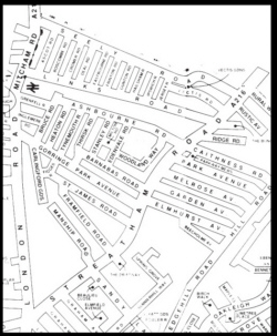
Detail from a modern street map showing the area covered by this book.
Reproduced by permission of Merton Design Unit, London Borough of Merton
NORTH MITCHAM
ACKNOWLEDGEMENTS
My collection of material for North Mitcham commenced some 35
years ago, the quest being greatly facilitated by numerous friends and
contacts at Mitcham, Wimbledon, Morden and Wandsworth libraries,
archivists at Castle Arch Guildford and in the Minet library of Lambeth
and, of course, at the former Surrey Record Office at Kingston. To all
of them I will always be grateful, and trust they will understand if I do
not mention them by name.
This year (2001), whilst my gleanings were being prepared for
publication, numerous drafts were read and re-read with incredible
patience by friends and fellow members of Merton Historical Society
who form the ‘editorial panel’ – Judith Goodman, Lionel Green, Tony
Scott and lastly, but certainly not least, Peter Hopkins, who also prepared
the text and illustrations for the printers. To them I am especially
indebted.
Finally, I would like to thank Audrey Thomas who, in addition to reading
the text, contacted Patrick Loobey and obtained his consent for
photographs of Gorringe Park to be used; and Merton Libraries
Department, who many years ago allowed me to copy several old
postcards and the drawing of Tamworth House in their possession.
These, supplementing various photographs and maps of my own, have
been used with good effect by Peter to leaven the text.
E.N.M.
CONTENTS
INTRODUCTION …………………………………………………………………………….. v
ACKNOWLEDGEMENTS ……………………………………………………………. viii
MAPS AND ILLUSTRATIONS …………………………………………………………. x
1 THE MIDDLE AGES ………………………………………………………………….. 1
The Background ……………………………………………………………………… 1
The William Figges, father and son …………………………………………… 3
The Estate of Merton Priory in North Mitcham ………………………….. 7
2 THE MANOR OF BIGGIN AND TAMWORTH …………………………..15
3 FIGGES MARSH ……………………………………………………………………….23
4 TOOTING JUNCTION TO LAVENDER AVENUE ………………………29
Road and Rail………………………………………………………………………..29
Tooting Old Hall ……………………………………………………………………33
Swains Farm………………………………………………………………………….37
Figges Marsh, or Tamworth, Farm……………………………………………38
London Road Cemetery and Tamworth Farm Recreation Ground..42
The Poplars …………………………………………………………………………..45
5 POTTER & MOORE ‘PHYSICK GARDENERS’ OF MITCHAM …..49
6 RENSHAWS CORNER ………………………………………………………………63
The Oxtoby Houses, or ‘The Chestnuts’…………………………………….63
Lock’s Lane and Eastfields Road ……………………………………………..70
The Willows and Manor Cottage ……………………………………………..74
7 BIGGIN FARM AND GORRINGE PARK ……………………………………77
The Tudor and Stuart Periods ………………………………………………….77
The 18th Century …………………………………………………………………..81
Biggin Grove and the Matthews ………………………………………………83
Lord Redesdale and Tamworth House………………………………………85
Gorringe Park House and William and Fanny Harris………………….89
Gorringe Park – The Last Years ………………………………………………94
8 THE STREATHAM ROAD …………………………………………………………99
Roe Bridge ……………………………………………………………………………99
A Country Lane ………………………………………………………………….. 103
The Impact of the Railways …………………………………………………. 105
Urbanisation ………………………………………………………………………. 107
NOTES AND REFERENCES ………………………………………………………… 115
INDEX………………………………………………………………………………………… 135
NORTH MITCHAM
MAPS AND ILLUSTRATIONS
J C Buckler’s drawing of ‘Tamworth Manor House’ (c.1827) ……………. Cover
Part of John Rocque’s map of London in 1741–45 ………………………………… ii
Detail from a modern street map showing the area covered by this book .. vii
Seal of Sir William Mauduit, the king’s chancellor ……………………………….10
Coat of arms of William Mauduit earl of Warwick ……………………………….10
Coat of arms of London Borough of Merton ………………………………………..13
Sale particulars, manor of Biggin and Tamworth, 1853 …………………………14
General view of Figges Marsh from south, 1970 ………………………………….22
Figges Marsh (looking north), 1975 ……………………………………………………28
Tooting station (disused), c.1975………………………………………………………..29
The milestone at Figges Marsh, c.1970 ……………………………………………….31
Figges Marsh gate – Return from the Derby, 1845………………………………..32
Late 19th-century engraving of Tooting Old Hall …………………………………33
Enclosure of common land – Figges Marsh, 1858 ………………………………..35
Tamworth Farmhouse, 106 London Road, 1974 …………………………………..41
London Road frontage of Tamworth Recreation Ground, 1967 ………………43
Upper Mitcham 1894–96, from the 25″ to 1 mile Ordnance Survey Map ..56
Site of Potter & Moore’s premises, London Road, 1970 ………………………..62
Extract from 1898 sale particulars of The Chestnuts……………………………..68
The houses at Renshaw’s Corner, Streatham Road, 1966 ……………………….69
Streatham Lane, looking north from Figges Marsh, c.1910 ……………………76
Tamworth House, c.1820 …………………………………………………………………..86
Gorringe Park House ………………………………………………………………………..92
The Avenue, Gorringe Park ……………………………………………………………….92
Reduced extract from the 25″ to 1 mile Ordnance Survey Map of c.1914 ..95
Melrose Avenue, c.1910 ……………………………………………………………………96
The Merchant Taylors’ stone, Roe bridge, c.1970 …………………………………98
Roe bridge – south parapet showing boundary plaque, 1972 ………………..100
John Perring unveils the new commemorative plate, 1992 …………………..102
St Barnabas’ church, Gorringe Park Avenue, 1975………………………………109
James Pascall & Sons’ works, c.1970 ……………………………………………….. 111
Gorringe Park School …………………………………………………………………….. 113
Group I, Gorringe Park School, c.1911 …………………………………………….. 114
Shops in Streatham Road, c.1911 ……………………………………………………..134
Chapter 1
THE MIDDLE AGES
The Background
Nothing of archaeological significance has ever been reported from
north Mitcham, and there is little to indicate when this part of the parish
was first permanently settled. There are, however, signs that before the
Norman Conquest, perhaps during the reign of Cnut or his son Harold
Harefoot, there may have been people of Scandinavian origin living in
the area.
Swains Farm, lying off Swains Lane, could in some way have been
connected with Swein, who had a substantial landholding in Tooting
during the reign of Edward the Confessor.1 This idea was suggested by
Mawer and Stenton, and although the connection cannot be proved, it
is an interesting hypothesis.2 In its various forms the name Sweyn was
not uncommon in England in the 11th century, but the thought that in
north Mitcham Swains Farm might embody the memory of a settler of
Anglo-Danish descent is certainly intriguing, although it is unlikely
ever to be more than conjecture.
The theory of Scandinavian settlement is not without other support,
however. The place-name Biggin (as in Biggin Farm) is mentioned in
late 13th and early 14th century records dealing with north Mitcham. It
is fairly common in the Midlands, where it is derived from the Middle
English ‘bigging’, a building or a house. Further north, and in Scotland,
it was more specifically used to mean a roughly-constructed dwelling
of clay and wood.3 Mawer and Stenton considered this place-name
element to be of Scandinavian origin. They concluded that since it is of
relatively late appearance in Mitcham the name might be attributable
to migrants from the Midlands, where it occurs as far south as
Hertfordshire which, until the country was united under Athelstan, was
on the borders of Danelaw. Tamworth, which as the family name ‘de
Tamworth’2 first finds mention in a record of a land holding in north
Mitcham in the early 14th century, similarly implies a past link with
the Midlands and the area under Danish domination after the 9th century
treaty of Wedmore. London, of course, has always attracted merchants
and settlement by people of many nationalities. In 1017, following the
NORTH MITCHAM
defeat of Edmund, London with the rest of England actually came under
Danish rule. With Merton already a place of note at this time,4 and
connected to London by a major highway, it would not be surprising to
find evidence of Danish settlement in the vicinity.
The Domesday survey of 1086 recorded nothing readily identifiable
with north Mitcham. A case can be argued, however, for equating this
part of the borough with a small estate in Wallington hundred, owned
by the abbey of St Peter at Chertsey.5 Tooting, or more precisely Lower
Tooting and Tooting Graveney, on the north bank of the Graveney (and
hence in the hundred of Brixton) was also held by Chertsey.6 At the
time of the Conquest the land on the Mitcham side of the border was
assessed at a mere half a hide, and therefore quite small – perhaps 60
acres or so in extent. It was in the hands of Wulfward, a Saxon who, we
are told, “could turn where he would” – in other words, he was a
freeman. By the time of the Domesday survey there was only one tenant
family living here, the head of household being classed as a ‘cottager’
and therefore a person of humble status. The holding included five
acres of meadowland, which one would expect to find bordering the
river. We can understand how the Domesday clerks failed to describe it
as being in Mitcham, for physically, like most of north Mitcham,
Wulfward’s land was separated from the centre of the village by an
area of marshland, a remnant of which still survives as Figges Marsh.
By 1086 Wulfward had been dispossessed, and his land in Wallington
hundred, with the rest of Chertsey Abbey’s property in Tooting, was in
the hands of Hamo, the sheriff of Kent. It seems safe to conclude that
Wulfward probably suffered the fate of the majority of the English
landowners summoned to thefyrd in 1066, and that if he did not actually
lose his life, his lands would have been forfeited to the Norman
conquerors. Although in value his holding in Mitcham was insignificant,
Wulfward had been a man of some substance, for his name appears
elsewhere in the Surrey Domesday folios, where he was recorded as
owning a further three hides of land in Wandsworth. Here, together
with five other freemen in possession of land held directly from King
Edward, Wulfward lost his estate to Ansculf (or Ansculf de Picquigny),
sheriff of Surrey and Buckinghamshire, one of the great Norman barons.7
THE MIDDLE AGES
By the time of the Domesday survey Ansculf was dead, and his estates
in Surrey had passed to his son. Some rancour obviously still attached
to the manner in which these transfers of title were effected, for the
men of Brixton hundred giving evidence to the King’s Commissioners
conducting the enquiry in 1086 complained that they had “seen neither
seal nor a deliverer”.
The William Figges, father and son
The earliest record of a grant of land in Mitcham to have come down to
us dates from the reign of Henry I, and involved two hides, conveyed
to Robert the son of Wolfward (sic) and Walter le Poure, to be held in
capite, i.e. directly of the king.1 Henry, the third son of the Conqueror,
seized the throne of England in 1100 on the death of his brother William
II (William ‘Rufus’, who was shot whilst hunting in the New Forest).
Henry had united the Saxon and Norman royal houses by his marriage
to Matilda, daughter of Malcolm III of Scotland and niece of Edgar
Atheling, and enjoyed a degree of popular support amongst his English
subjects for his disapproval of William’s rapacious policy. To make his
position more secure (his right to the English throne was contested by
his eldest brother, Duke Robert of Normandy), and to consolidate
dissident factions in the realm, Henry granted a charter promising reform
on his accession. Particularly welcomed by the English was his
undertaking to abolish oppressive feudal dues, and to reinstate many
of the laws of Edward the Confessor.
The idea that the loss suffered by the Saxon Wulfward in the aftermath
of 1066 might have been redressed by the return of the land to his son
Robert early in the 12th century is attractive, but without documentary
support. The grant certainly states that Robert was the son of
“Wolfward”, but the name (however spelt) was probably not uncommon,
and we can by no means be sure it was Robert’s father who had been
dispossessed after the Conquest. Later records do show a remarkable
continuity of tenure of this estate in Mitcham, however, and demonstrate
that the heirs of Robert Wolfward (or Fitz Wolfward, as he was
sometimes styled) together with le Poure’s descendants, retained the
trust of the Establishment until the end of the century. Holding the land
NORTH MITCHAM
in ‘serjeanty’, that is having the duty of performing a specific service
to the king, they were government officials, charged with the important
responsibility of providing secure accommodation for prisoners arrested
by the sheriff in the vill of Mitcham and detained pending appearance
before a court. Those apprehended would have been held on suspicion
of committing serious crimes, such as homicide, arson, rape, housebreaking
and robbery, which lay beyond the jurisdiction of the local
moot. Such matters came within the sphere of Henry’s justiciar, an
office which in the 1120s was held by Ralf Bassett and subsequently
his son Richard, both high-ranking judges in what today we would call
the office of the Lord Chancellor.
Between 1106 and 1125 the shrievalty of Surrey was held by Gilbert
‘the Knight’ who, soon after being granted an estate at Merton by King
Henry in 1114, had founded the great priory which survived on the
banks of the Wandle until 1538. Henry’s assignment of the Mitcham
land to Fitz Wolfward and le Poure must have preceded his death in
1135, and it could therefore have been either to Gilbert, or later his
nephew Fulk, who succeeded him in the office as sheriff from 1126–
1129, that Robert and Walter were directly answerable.2 A document
from the reign of John (1199–1216) reiterated the stipulation that
detainees, apprehended on the order of the sheriff “either in the fact, or
on suspicion of some offence”, were to be held for up to “one night and
one day” in a house provided “at the owner’s proper costs” before
being conveyed to the castle at Guildford “with the aid of the County”.
It was also laid down that Robert Fitz Wolfward and Walter le Poure
should provide a ‘puntfold’, or pound, in which to keep ‘distresses’,
most likely farm stock or domestic chattels seized on the sheriff’s orders
in lieu of unpaid taxes or fines, or forfeited by convicted felons. In the
performance of their duties Fitz Wolfward and Le Poure were required
to attend the hundred court at Wallington, and to pay the king by the
hand of the sheriff ten shillings a year for the land they held.3
During the chaotic reign of Henry III (1216–1272) a Matthew Fitz
Bulward contrived to sell part of the estate formerly held by Wolfward
and le Poure, and was about to dispose of the remaining portion when,
not surprisingly, he was stopped by order of the king. “A writ was
THE MIDDLE AGES
directed to the Sheriff, ordering him to see that the king’s command
herein be obeyed”.4 The land subsequently passed through the hands
of various tenants-in-chief, including William le Bule, whose widow
Margery was licensed in 1318 to transfer the tenancy to John le
Bockyng.5 The property thus ‘alienated’ i.e. conveyed, comprised “one
messuage, 18 acres of land, 1 acre and a half of meadow and 2s.6d.
rent”, still held of the king, that is, without any intermediate landlord.
Bockyng(e) was described as a “taverner”, and is therefore of special
interest since he has the distinction of being the first inn-keeper of
whom we have record in Mitcham.6 A similar transfer of tenure occurred
in 1332, when Thomas de Sutton received consent to ‘enfeoff’ the land
to Thomas Godard (sic).7
Thus it transpired that in the reign of Edward III William Figge appeared
on the Mitcham scene, holding as his demesne a “messuage and 16
acres” being, we assume, most of the land originally granted to
Wolfward and le Poure.8 Figge was required to pay five shillings a
year in two equal instalments to the sheriff at Easter and Michaelmas,
but was otherwise under similar obligations to those of his predecessors
two centuries before. He was resident in Mitcham, and an enquiry held
in 1326 or 1327, on the death of Hugh le Despenser, junior, confirmed
that in addition to his own land “one Fige” had, until a short time before,
held a virgate of land (roughly 30 acres) as a tenant of the prior and
canons of Merton. The annual rental was four shillings. Precisely where
this land lay we are not told, but it is likely to have been in north
Mitcham.9 William Figge would certainly have been a familiar figure
at the court at Wallington, for his official duties carried him there every
three weeks. He died in 1349, whilst the Black Death was at its height,
leaving to his son and heir William the homestead and land in Mitcham,
still held directly from the king.10
That William Figge the younger remained in Mitcham, where he was
undoubtedly regarded as an important member of the community, is
evidenced by two entries in the close rolls of Edward III, recording
Figge’s presence as a witness to the mortgaging in 1357 of the Hall
Place estate, owned by Henry de Strete, a London vintner.11 Figge’s
name occurs again in 1362, when William Mareys, a major landowner
NORTH MITCHAM
in Mitcham, conveyed a large estate on the banks of the Wandle in
trust to the perpetual vicars of Mitcham and ‘Westmorden’.12 William
Figge junior died in late 1370 or early 1371, the 44th year of the reign
of Edward III, “seized of a house and lands in Mitcham”.13 The name
of his immediate successor has not been traced, but Agnes, wife of
Geoffrey Prior, who died in 1405/6 during the reign of Henry IV, held
a house and land by the same service as the Figges.14 A family of the
Figges’ standing, both in the administration of justice and in the parish
of Mitcham, would have occupied a house commensurate with their
status. As we have seen, what appears to have been the same property,
within its 16 or 18 acres of land (accounts vary as to the precise amount),
occurs in the records for over 200 years. One could hazard various
suggestions as to where the house might have stood but, it must be
admitted, these would only be speculation.15
If our knowledge of the two William Figges is somewhat sketchy, we
are completely ignorant of the names and ultimate fates of their charges.
Although it was in disrepair by 1371 and partly demolished in 1379,
Guildford Castle was used as a prison throughout the Middle Ages,
and in the south-east corner of the 12th-century keep there survives a
room, once used as a chapel, on the walls of which can be seen graffiti
supposedly carved by prisoners. Had any of these unfortunates been
brought before the court at Wallington and, after sentence, afforded
such ‘hospitality’ as the Figges and others cared to procure for them en
route? By good fortune the Figge family’s name has come down to us,
but the identities of their charges have, it is sad to say, been lost forever,
although some may have achieved a nameless immortality by dint of
‘making their mark’ on the walls of their cell.
Guildford Castle has long since ceased to be used as a prison, but until
1986 Mitcham remained within the jurisdiction of the South West
London Petty Session’s Divisional Court at Wallington, and cases arising
from offences committed in Mitcham were heard before the magistrates
at Wallington.
THE MIDDLE AGES
The Estate of Merton Priory in North Mitcham
From the early 12th century until the Dissolution of the monasteries by
Henry VIII north Mitcham fell within one of the many estates belonging
to the priory of Merton, in this instance extending beyond the borders
of Mitcham into Streatham. Since its foundation shortly before 1117,
Merton Priory had attracted many gifts of land, both from major
landowning families as well as persons of lesser rank, all motivated by
the desire to show favour to the Church, and in the hope of eternal
salvation. These benefactions continued throughout the medieval period,
with the result that by the close of the 15th century the prior and convent
of Merton had become landlords of much of north and north-east
Mitcham.
The precise extent of these woods and farmlands is now difficult to
establish. It is a reasonable assumption, however, that very broadly
they corresponded with the estate over which the prior and convent, as
lords of the manor of ‘Byggyng ‘t Tamworth’, exercised jurisdiction at
the time of the Dissolution in 1538, and which survived as the manor
of Biggin and Tamworth until the 19th century.1 If this is correct, the
priory’s lands would presumably have included the commonland known
as Figges Marsh and part of the Upper Green, have extended to the
river Graveney and over the border to take in part of Streatham, and as
far as Pollards Hill and the parish boundary with Croydon north-east
from Mitcham Common.
By whom and when the constituent parts of the priory’s lands in
Mitcham were granted is not known, but it seems quite possible that
the principal benefactor was Henry I’s son Robert, the earl of Gloucester,
for by the early 14th century the priory’s estate in Mitcham was largely
held of the honour of Gloucester. It is also feasible that this was, in
essence, the holding of the Saxon Brictric who, in the reign of Edward
the Confessor, was in possession of land amounting to roughly one
fifth of Mitcham and also lying, as far as we can judge, to the northeast
and east of the Upper Green. By 1086 much of this estate had been
granted by Bishop Odo, one of the Conqueror’s half brothers, to the
canons of Bayeux. The canons’ tenure did not long outlast the bishop’s
disgrace, however, and by 1088 the property had reverted to the Crown.
NORTH MITCHAM
At the time of the Domesday survey the remainder of Brictric’s lands
in Mitcham had been granted by the bishop as two separate holdings of
one hide and a half hide (very approximately 120 and 60 acres
respectively) to Odbert and Ansgot.2 Since Odbert possessed land over
the border in the vill of Tooting, whilst Ansgot held Streatham, it seems
highly likely that their holdings in Mitcham were in the north-east,
close to the boundaries of what would eventually emerge as the parishes
of Tooting and Streatham.
In 1121 Henry I, son of the Conqueror, assented by charter to the transfer
of the royal estate at Merton, including lordship of the manor, to the
prior and convent of the newly established priory of Merton. Robert de
Caen, Henry’s natural son, had been created earl of Gloucester in 1120.
He was already a man of great wealth and influence, possessing estates
in England totalling many thousands of acres, and it seems, although
confirmation is lacking, that as we have already suggested it was Robert
who granted the north Mitcham estate to Merton Priory. Earl Robert,
who was a staunch supporter of his half-sister the Empress Matilda
during the civil war which marked much of Stephen’s reign, died in
1147. Whatever befell the Gloucester estates, there appears to have
been no adverse impact on the priory’s holding in north Mitcham which,
as Church property within his diocese, would have enjoyed the
protection of the powerful Henry de Blois, bishop of Winchester and
brother of Stephen.
What seem to be amongst the earliest recorded tenancies granted in
Mitcham by Merton date from the period 1222–31. One of them noted
that Giles, the prior, acting in conjunction with the convent, granted to
“Roger son of Adam de Mecham and his heirs” half an acre of land
called Laca, the rental being one penny per annum. At about the same
time “Walter, son of Giles” was granted tenure of a ‘messuage’, i.e. a
house with land and appurtenances, at an annual rental of two shillings.
Exactly where these two properties were situated was not specified.3
Both grants provide examples of the priory using land it had been given
as a source of income from rent. In the conditions attached to another
tenancy, we have an illustration of how the priory secured labour service
as well as an annual income. Some time between 1263 and 1293 a John
de Lana was the occupier of a house with four acres of land behind it,
THE MIDDLE AGES
owned by the priory. His rent was three shillings, in addition to which
he had to provide 24 men for the autumn harvest (the priory supplying
them with two meals a day) and 50 men at their “great harvest”.4
Early in the 13th century Merton Priory had been in possession of land
in Mitcham which by ancient custom conferred on the owner or his
tenants rights of common pasturage on the parish waste. The precise
extent of the lands over which these rights might be exercised was
evidently disputed, as can be seen by proceedings in 1240, when the
prior of Merton joined with the prior and convent of St Mary at
Southwark and other freeholders in Mitcham as plaintiffs in an action
against Agnes and William Huscarl of Beddington and others from
Beddington and Wallington, alleging that the Huscarls had driven off
cattle belonging to the plaintiffs. The court found for the injured parties,
who recovered their animals and were awarded 40 shillings damages.5
In June the same year an assize was held before Stephen de Sequentem
and other justices of the king to settle the matter of grazing rights claimed
by Mitcham and Beddington, Bandon and Wallington. According to
Heales, the evidence of the jury of 12 that the freeholders of Mitcham
and the other places had exercised common rights for over 20 years
was accepted by the court, and “the damages against prior” were
assessed at 40 shillings.6 The issue was not finally resolved until early
in the 19th century, when an inclosure award granted lands formerly
part of Mitcham Common, but in Beddington parish, to the Carews of
Beddington.7
Gifts of land to Merton Priory continued throughout the 13th century.
In about 1242, for instance, the prior and convent received from a
Richard Duce nine acres of land and a building in Mitcham.8 Other
early gifts were those of “Laurence son of William” who, in 1243,
granted to Robert, the prior of Merton, the rental of property in Mitcham
worth 20 shillings,9 and that of Amysius de Wauton or Walton who, in
1248, transferred title of a carucate or hide of land (normally about 120
acres) to the priory.10
The Wauton family had held land in Mitcham from the Mauduit family
since the early part of the 13th century. Their landlord, Robert Mauduit,
one of the great officers of state and chamberlain of the Exchequer
NORTH MITCHAM
from 1194–1222, is said to have purchased properties in Mitcham and
South Streatham. Early in the 13th century (possibly during the four
years that England lay under the interdict imposed by Pope Innocent
III as a punishment for King John’s refusal to accept Langton as
archbishop of Canterbury) Robert Mauduit received licence from the
prior of Southwark for a chapel in his curia or “mansion house” at
Mitcham.11 This is an indication that Mauduit and his family were
from time to time resident in Mitcham (Robert’s duties would, of course,
have taken him all over the country) and also suggests that the licence
was granted whilst churches in England were closed on papal orders.
The licence would therefore have dated to before 1213, when John
came to heel and the interdict was lifted. The actual location of the
Mauduits’ house is unknown, and in 1218 he left Mitcham, granting
his property to a William de Teil. It was following the latter’s tenancy
that tenure passed to the Wautons.
The history of the priory’s estate in Mitcham during the remainder of
the 13th century is complex and somewhat difficult to follow from the
surviving accounts. This is not to say the records are silent, but that it
is impossible at this distance in time to correlate satisfactorily the
seemingly unconnected events recorded. Thus, in 1230 we have the
case of Roger de Walecot and his wife Alice, who sought to establish
their right to inherit an estate of 46½ acres, which was contested by the
prior of Merton. Henry III directed the sheriff of Surrey to bring the
case before the justices at the next assize at Lambeth. The case actually
Left: Seal of
Sir William
Mauduit, the
King’s
Chancellor
Right:
Coat of arms
of William
Mauduit Earl
of Warwick
THE MIDDLE AGES
took three years to settle, the “final Concorde” being registered at
Westminster in 1233, Roger and Alice being required to surrender the
land to William Mauduit on receipt of nine silver marcs.12 In 1250 the
prior and convent of Merton were said to be holding lands in Mitcham
of Robert’s son, Sir William Mauduit, by the token service of rendering
annually a pair of gilt spurs or sixpence.13 (Sir William, who became
the earl of Warwick, followed his father in office, serving as chamberlain
of the Exchequer from 1222–1257.) Relations between the priory and
Sir William appear not to have been entirely harmonious, for on at
least one occasion between 1249 and 1263 it was considered necessary
to record formally that Eustace, the prior, and the convent of Merton
exonerated Sir William and his heirs from all service due from him as
a tenant of land in Mitcham, on payment of agreed sums and the
exchange of tokens.14
The priory undoubtedly continued in favour with Henry III, however,
for while at Merton in 1252 the king confirmed by charter the priory’s
cherished right of free warren on its Mitcham estate, thus restoring to
the prior and convent the freedom to take game and fish on their own
land.15 (This action removed uncertainty which had arisen through the
extension of forest law to much of Surrey by the king’s grandfather,
Henry II.)
In 129116 and again in 1314/5 (when the lands and tenements on the
estate were valued at £10 per annum) the priory was confirmed to be
holding property in Mitcham as a tenant of Gilbert de Clare, earl of
Gloucester and Hereford, by the service of providing a quarter of a
knight’s fee.17 (The valuation was for taxation purposes, and had as
little relevance to its true worth as a modern banding of domestic
premises for council tax has to the market value of a house.) For the
purposes of the tax imposed by Pope Nicholas IV in 1291 the liability
of the priory’s estate in Mitcham was assessed at one pound and five
shillings.18 What was presumably the same estate is mentioned in the
records in 1347/8, when the country was in the grip of the Black Death.
On this occasion it was confirmed at an inquisition post mortem
following the death of Hugh de Audele, earl of Gloucester, that the
priory was holding land described as a quarter of a knight’s fee, and
valued at merely 30s. per annum.19
NORTH MITCHAM
In 1394 a further valuation of the priory’s estate in “the Ville of
Michelham”, deemed it to have been be worth £14 7s 8d, although this
had since been reduced drastically by “a tempest”.20 At the Dissolution
the manor of Biggin (whatever this comprised) was recorded as yielding
£11 1s 7d in rent.21
In 1373, when land owners were still struggling to adapt to the
depopulation and consequent decline in the labour force after recurrent
outbreaks of plague, Richard Clare was granted leave by letters patent
to assign various estates in Mitcham and elsewhere in Surrey to the
prior and his successors in perpetuity.22 A jury called that year to give
evidence at an enquiry confirmed that several properties in the parish
were already held by the priory. It is frustrating that none of them can
be identified with any certainty. Throughout the Middle Ages formal
confirmations of the priory’s tenure continued to be received and noted
in the Merton records, such as that at the inquisition post mortem held
in 1398/9, following the death of William, brother and heir of Thomas,
earl of Stafford, when it was again acknowledged that land at Mitcham,
comprising a fourth part of a knight’s fee, was held by the prior of
Merton.23
Biggin Farm which, by the late 19th century, formed an integral part of
the north Mitcham estate of Gorringe Park, first received specific
mention in 1301, when it was described as “La Bygginge”, one of the
priory’s tenanted properties.24 A subsidy for his Holy Land campaign
had been required by Pope Boniface VIII, and Merton Priory raised the
sum required partly from the sale of corn, barley, beans, peas and
‘spikings’, or lavender, and partly by payments extracted from its various
tenants. Biggin, we are told, contributed two shillings. Edward I at this
time was in need of finance for his Scottish wars and is said to have
prevailed upon the priory to lend him £50 out of the money collected.25
Tamworth, which as a place-name in Mitcham is understood to occur
in a rental of three crofts of land held in 1531–2 by a William Pratt,
was seen by Mawer and Stenton as “probably a manorial name, from
the family of John de Tamworth”. It is said to be listed amongst the
Feet of Fines for 1351 and in the Patent Rolls of 1354, and use of the
term ‘croft’ to describe Pratt’s land hints that it originated as enclosures
THE MIDDLE AGES
of cleared waste or woodland around a small homestead.26 In the
absence of any other explanation, both Biggin and Tamworth can be
assumed to have had their beginnings in separate parts of the priory’s
Mitcham estate gifted by the earls of Gloucester and Stafford. By the
early 16th century the two seem to have merged to form one unit. A
clue to the location of the medieval homestead of Biggin may exist in
the position of Tamworth House, a newly-built ‘Regency’ villa shown
on early 19th century plans to have occupied a site between Biggin
Farm and Streatham Lane.
Following the Dissolution, much of the priory’s Mitcham estate, together
with lordship of the manor of “Bygging” and Tamworth, was granted
by Henry VIII in 1544 to Robert Wilford, a London merchant,27 who
was already in possession of an estate in Lower Mitcham inherited
from his father James Wilford.28 The priory’s lands had extended into
Tooting Graveney, Streatham and Clapham, and comprised 640 acres,
including 200 of woodland.29 “Estmicham” and the “Mareshlandes”
in Mitcham and Carshalton are mentioned in the Ministers’ Accounts
of 1538.30 In north Mitcham Wilford’s holding took in Biggin Farm,
part of “Fenny Mead” (later known as Fleming Mead),31 and extended
to the “Amery Lands” and “Begrave Hill”, both in the Colliers Wood
area.
The coat of arms of the
present London Borough of
Merton incorporates the fret
from Merton Priory’s arms as
well as three sprigs of
Mitcham lavender.
NORTH MITCHAM
LOT 81
THE VALUABLE AND EXTENSIVE
MANOR OF BIGGIN & TAMWORTH,
With Court Baron, Court Leet, Quit Rents, Fines Arbitrary, Heriots, Royalties,
Tolls, Rights Members, Privileges, and Appurtenances, extending over all Parts
of the Commons and Wastes in the Parish of Mitcham, of about
565 ACRES.
£ s. d..
The Copyhold Tenants of this Manor are 65 in number, and pay annual Quit Rents, amount
ing to about ……….. 11 50
The fines upon admission have realised annually upon an average of the last ten years . 150 0 0
The Tolls of the Fair on Mitcham Green have realised annually upon an average of the last
ten years (subject to trifling costs of collection) . . . . . . 19 13 10
The sale of Gravel, &c., from the Commons, has realised upon an average of the last five
years (net)………… 24 00
Total per annum . £204 18 10
A Common Keeper has been appointed by the respective Lords claiming rights over the Commons, and a Lease has
been granted to such Common Keeper, a copy of which will be produced at the sale.
The customs of the Manor are, as to the descent of Copyholds, of the nature of Borough English, the Estates
descending to the youngest son. The Lord is entitled, for a Heriot on the death of every Copyholder, to the best animal
but in a few instances to a given sum as a Heriot certain. The fine is arbitrary upon admission, on death, or alienation,
except in a few instances where the fine is certain. The arbitrary fines have been generally assessed upon two years’
improved annual value of the Copyhold.
The Manor is offered with such rights as the Lord may, as such, be entitled to in and over the soil of the extensive
and valuable Commons and Waste Lands in the parish of Mitcham, and subject to such Rights of Common as the tenants
of the Manor and others may be entitled to, and subject also to an annual Farm-rent of £1 5s. 7d., reserved by the Grant
of the Manor by Henry the Eighth, and now payable to John Routh, Esq.
The rare advantages of possessing such a property as this to professional gentlemen and others, particularly so near
the Metropolis, with the extensive Commons and Wastes in the parish (which, no doubt, will, at no far distant period, be
inclosed, and thereby rendered even more valuable and desirable in many respects), together with the powers and
benefits given to Lords of Manors by the Copyhold Enfranchisement Acts, are so well known as not to require further
comment or recommendation.
GARRAWAY’S COFFEE HOUSE, ’CHANGE ALLEY, CORNHILL, LONDON.
August, 1853.
Sale Particulars, Manor of Biggin and Tamworth 1853.
Chapter 2
THE MANOR OF BIGGIN AND TAMWORTH
Although the point at which the manor of Biggin and Tamworth came
into being remains somewhat obscure, Brayley (not, it must be said,
always a totally reliable authority) was prepared to speculate that it
was “probably one of the manors held by Fitz-Ansculf at the time of
the Domesday survey”.1 The word ‘manor’ did not come into use in
England until after the Conquest, and it was not actually used by the
Norman clerks to describe either of Fitz-Ansculf’s holdings in Mitcham.
Like many of his contemporaries, Brayley was using the term to convey
the common conception of a manor as a unit of local administration,
coterminous with but distinct from the ecclesiastical parish, dominated
by the squire and ruled through the courts baron and leet. In reality the
situation in medieval England was often very different and more
complex. Brayley quoted no evidence in support of his supposition,
and his comment is best ignored.
We have examined in the previous chapter the evidence showing that,
by the mid-13th century, Merton Priory was in possession of a large
estate in Mitcham. Without doubt this incorporated one or more former
Saxon holdings, and we can be sure that to the customs and practices
followed since before the Conquest new procedures would have been
introduced by the prior and convent for the control of their tenantry
and the efficient running of the property. The manor of Biggin emerged
during the 12th century as an area in which the priory also administered
criminal justice, the annals of Merton recording that it was proved to
the satisfaction of the king’s justices sitting at Guildford in 1278 that
the ‘liberties’ or privileges enjoyed by the priory in its estates in various
parts of Surrey had been granted by Henry II in the latter half of the
12th century. These included not only the right of sac and soc (to hold
and control a manorial court and receive profits and services), but also
thol and theam (to try and punish offenders), and infangenetheof and
outfangenetheof (the right to arrest and sentence thieves and, if
necessary, to pursue them should they flee the manor).2
These were difficult times, and the severity with which the prior and
convent were prepared to deal with miscreants can be judged by the
report to the Bermondsey assize in 1258 that the prior had erected a
NORTH MITCHAM
gallows at Merton.3 Precisely where this was is not stated, but the
evidence suggests it could well have been on a small patch of common
land near where Church and Western Roads now meet Christchurch
Road, just outside the priory precinct. Here, at a cross roads where the
parishes of Merton and Mitcham met, was a typical site where the
consequences of wrong-doing could be made plain to all who passed
by. Known locally as Jacob’s Green, a small piece of waste land survived
here until the early 20th century. The court rolls confirm that it was
regarded as being waste within the manor of Biggin and Tamworth,
and record several grants of enclosure during the 19th century by which
it was progressively reduced in extent.4 Whether or not the priory’s
gibbet was a permanent feature here during the Middle Ages is not
known, but the memory of it seems to have been enshrined in the names
by which nearby fields like Hanging Hook, Hanging Field and Hell’s
Acre, were still known as late as the 1840s.5
In 1314/15 the prior and convent of Merton were confirmed to be
holding the manor of Biggin, comprising lands and tenements at
Mitcham worth £10 p.a., as tenants of Gilbert de Clare, earl of
Gloucester,6 and the last four priors before the Dissolution are recorded
in the court rolls as lords of the manor of Biggin in “Mycham” in 1484,
1502, 1520 and 1537.7 As the manor of Biggin and Tamworth, by which
name it was known after passing into lay ownership, the estate is not
mentioned until 1538, when the Firma Man’ de Byggyng ‘t Tamworth
appears in the ministers’ accounts listing property belonging to Merton
Priory.8 The perquisites of the manor court at Mitcham, i.e. fines, quit
rents etc., were then valued at 7 shillings a year.9 In 1544 lordship of
the manor, together with an estate comprising land in Carshalton,
Tooting Graveney and Streatham as well as Mitcham, was granted to
Robert Wilford (or Wylforde), “Citizen and Merchant Taylor of
London”, and his wife Joan.10
The rolls of the manor covering the years from 1484 to 1882 survive,
and are in the care of Surrey History Centre. The earlier rolls,
unfortunately for many students today, still await translation from the
Latin in which they continued to be written by the stewards’ clerks
until the 17th century. Together with nine rentals and terriers of 1861,
and plans of various properties still within the jurisdiction of the manor
THE MANOR OF BIGGIN AND TAMWORTH
in the 19th century, the collection is a readily accessible and potentially
important source of local history material for future research.
Through the medium of these records and published histories the descent
of the lordship of “Bigging in Mitcham”, and subsequently of the manor
of Biggin and Tamworth, can be traced with ease. It was the general
practice of topographical and county historians writing in the late 18th
and 19th centuries to recount in great detail the passage of ownership
of the manors, for the subject was one of considerable interest and
fascination to their wealthy patrons and others who, it was anticipated,
would purchase the published works. Thus Daniel Lysons, supplied
with extracts from the court rolls of Biggin and Tamworth by Richard
Barnes, the steward of the manor, gave the following summary in 1792:–
“The manor Bigging and Tamworth belonged to Merton Abbey,
and was granted by Henry VIII after the suppression of that
monastery to Robert Wilford, merchant taylor, for the sum of
£486 14s. In 1569 it appears to have been the property of John Lord
Mordaunt, in right of his wife. In 1582 Henry Whitney, Esq., held a
court as lord of this manor, though it appears that he purchased a
moiety thereof the ensuing year of Robert Aprece, Esq. The Whitneys
alienated the manor in 1603 to Sir John Carrill. Three years
afterwards it belonged to John Lord Hunsdon, whose son sold it in
1614 to Sir Nicholas Carew, alias Throckmorton. It was alienated
about the year 1655 to Edward Thurland, Esq., and continued in the
same family till 1744, when it was purchased of the devisees of
another Edward Thurland by John Manship, Esq., father of the
present proprietor.”11
Wilford obviously had the financial resources to meet the king’s price,
and by his purchase of the lordship of the manor, together with a large
estate, greatly enhanced his social status. Unfortunately Robert Wilford
had not long to enjoy his newly acquired position in local society, for
he died in September 1545. His will was proved at London two months
later.12 In it he left to his wife “Johane”
“All that manner of Biggin with appurtenances in Mitcham and all
the capital messuage or tenement with appurtenances and all my
other messuages, lands and tenements in Mitcham and elsewhere in
NORTH MITCHAM
the county of Surrey to have and to howld for life, and after her
death to William Wilford my son and heir apparent. In default of
issue, to Anne Wilford, Johan Wilford and Auderey Wilford my
daughters. In default of issue, to Nicholas Wilford my brother.”
Following Robert Wilford’s death Joan remarried, taking as her second
husband Lord Mordaunt. It was in part through the Wilfords’ daughter
Anne, who married a Henry Whitney, “servant to Sir Thomas Bromley,
the Lord Chancellor”, that the lordship of the manor of Biggin and
Tamworth passed into the hands of the Whitney family. The portion
purchased from Aprece, or “Apprice”, had been the inheritance of
Anne’s sister and co-heir Johan, whom Robert Aprece had married. In
July 1580, at Henry Whitney’s request, Queen Elizabeth confirmed the
grant of free warren in his domain lands in Mitcham, originally granted
by Henry III to Merton Priory.13 The important right to hunt was thus
secured for the Whitneys and future owners of the manor, and this
remained a valued manorial asset until the closing years of the 19th
century, when the taking of game in the woodlands towards Pollards
Hill was the preserve of those possessing the shooting rights.
The Whitneys retained lordship of the manor of Biggin and Tamworth
until the reign of James I and then, in June 1603, they sold it, together
with various parcels of land in Mitcham totalling 100 acres, plus land
and appurtenances in Tooting Graveney and Streatham, to Sir John
Carryll (sic) of Warnham, Sussex.14 Sir John in his turn sold to the Rt.
Hon. Sir John Carey from whom the manor was purchased by Carew
in 1614.15 As can be seen from Lyson’s account above, several further
changes of ownership ensued during the reign of James I.
The Carews, whose seat was at Beddington, were Royalists and suffered
as a consequence of their support of Charles I during the Civil War. Sir
Nicholas died in 1644, and was succeeded by his eldest son, Sir Francis,
usually described as “of Reigate”. Sir Francis, his finances in ruins and
heavily penalised by Parliament for his loyalty to the Crown, was
obliged to mortgage his Norbury and Mitcham estates in 1647. He died
in 1649, still in debt, and lordship of the manor of Biggin and Tamworth
passed from his widow Mary into the hands of Edward Thurland of
Reigate and the Inner Temple.16 Thurland, “a gentleman entitled to
THE MANOR OF BIGGIN AND TAMWORTH
bear arms”, amongst other positions held the stewardship of the estate
of the earl of Warwick. He was also a senior justice of the peace, often
taking the chair at Surrey quarter sessions. His sphere of activity on the
bench appears to have been mainly in the Reigate area, where he was a
prominent citizen.17 John Manship, to whom Thurland’s son Edward
sold the manor in January 1744/5, was a director of the East India
Company, already resident in Mitcham at The Canons, which he had
leased a few years previously from the Cranmer family. Having acquired
a substantial estate in Mitcham, as well as the lordship of the manor of
Biggin and Tamworth, Manship most likely intended moving with his
family and household to Biggin Grove, possibly after rebuilding or
refurbishment, but this was not to be and he died in 1749 whilst still
resident at The Canons.18
Manning and Bray set out the descent of the manor in considerably
more detail than outlined above, and further elaboration here is
unnecessary.19 Manship devised the estate to his wife Elizabeth during
her lifetime, after which it passed to his only son, John. In 1804 the
latter sold the manor and the family estate in Mitcham to James Moore,
proprietor of the firm of Potter and Moore, physic gardeners and
distillers of essential oils, who thereupon became a major landowner
in Mitcham.
Until more work is possible on the surviving documents, the actual
extent of the land within the manor’s jurisdiction must remain somewhat
uncertain. The Victoria County History of Surrey, unfortunately wrong
in so many details in its account of Mitcham, is only partly correct in
asserting that the manor lay “beyond the railway bridge off the Croydon
Road”.20 Several houses in central Mitcham are known to have been
copyhold of the manor, including Durham House and the Nag’s Head
public house, both of which overlooked Upper Green West, as well as
land in north Mitcham.4 In 1544, when the manor extended beyond the
bounds of Mitcham into the neighbouring parishes of Tooting Graveney
and Streatham, it comprised 640 acres, including 200 acres of wood,
and much of the common pasture or waste land of Mitcham.21 As late
as the mid-19th century it included, in the extreme north-west of the
parish, several small parcels of common land. As we have seen, one of
these, Jacob’s Green, abutted surviving fragments of the precinct wall
NORTH MITCHAM
of Merton Priory,4 whilst others lay either side of the river Wandle at
Phipps Bridge.22 These plots of waste ground were obviously vestiges
of the former priory estate and had passed with the manor to Robert
Wilford in 1544.
In the late 18th century it was to the lady of the manor of Biggin and
Tamworth that the parish officers applied for consent to enclose part of
Mitcham Common for the erection of a new workhouse, and 30 years
later permission was given by James Moore for a further enclosure of
common land to provide a site for a windmill. The Upper, or Fair, Green
was by custom the venue for the annual Mitcham Fair, tolls from which
were collected from the showmen by the steward of the manor, and the
then 50 or so acres of Figs, Figges or ‘Pigges’ Marsh comprised another
portion of the parish waste acknowledged to be within the manor.23
It is evident from a series of enclosure grants made in the mid-19th
century that the lord of the manor still claimed, and was exercising
without apparent opposition or protest, rights over areas of roadside
waste remaining in several parts of Mitcham. Including those mentioned
above, land fronting London Road north of the Swan inn as far as
Tooting parish boundary, and other plots bordering Mitcham Common
along Commonside East up to New Barns Farm were fenced off and
sold.4
When rights over the main expanse of Mitcham Common were in
dispute between 1801 and 1819 and wholesale enclosure was proposed,
it was claimed for the lord of the manor of Biggin and Tamworth that
his jurisdiction extended over the entire Common lying within the civil
and ecclesiastical parish of Mitcham. This was, however, strongly
contested by the lords of the other Mitcham manors of Mitcham Canons,
Ravensbury and Vauxhall, and also by the lord of the manor of
Beddington and Bandon. It required lengthy litigation, culminating in
a High Court ruling delivered on appeal, before the boundaries of Biggin
and Tamworth on Mitcham Common, and those of the other manors,
were settled.24
In James Moore’s time a Common keeper and herdsman was appointed
jointly by the lords of the Mitcham manors to prevent over-grazing and
to impose a measure of control over the exercise of other common
THE MANOR OF BIGGIN AND TAMWORTH
rights, such as the gathering of wood and turves for fuel. By the end of
the century, when very few copyholders were left and rights to common
pasture were rarely exercised, it was no longer felt necessary to
safeguard the interests of the remaining tenants of the manor, and James
Bridger, Moore’s successor, seldom, if ever, took steps to curb
unauthorised grazing.25
In August 1853, two years after Moore’s death and on the instructions
of the executors, the “Valuable and extensive Manor of Biggin and
Tamworth” was offered for sale by public auction. The value of the
manor, both as a source of rents and income from the fines and levies
arising from the proceedings of its courts and, perhaps more importantly,
as a source of profit from the enclosure and sale of common land for
building purposes, was stressed in the particulars prepared for the
enticement of likely buyers. Annual quit rents from copyhold tenants
amounted to £11 5s 0d, and fines or fees levied upon admissions to
tenancy of the manor had averaged £150 over the previous ten years.
With fair tolls and the sale of gravel from the Common the total income
was a little over £200 p.a.26
Following the auction lordship of the manor passed to James Bridger,
Moore’s natural son, who also secured possession of the family business
and much of his late father’s freehold land and buildings. Within four
years of Moore’s death grants of enclosure of what in total amounted
to a substantial area of common ‘waste’ lying within the manor, were
made to owners of the adjacent land. In the main these enclosures
involved parcels of land bordering Figges Marsh, Commonside East
and Phipps Bridge Road, and the majority were formalised at a general
court baron and customary court of the manor in January 1858. Although
at first sight it might appear that Bridger was indulging in what today
would be considered ‘asset stripping’, there may well have been a need
to raise money to meet the many and generous bequests made by Moore
in his will. A shortage of working capital after the estate had been
settled could also have presented problems. Whatever the immediate
reasons, piecemeal disposal of the former Moore estate continued over
the next 30 years, and by the early years of the 20th century, the
compilers of the Victoria County History could comment that “Almost
all the manor of Tamworth has been parcelled out as a building estate.”
NORTH MITCHAM
Bridger died in 1885, and lordship of the manor was sold in 1888,27
passing through the hands of Paine and Brettell, solicitors of Chertsey,
before being acquired by the Prince’s Golf Club which had negotiated
a lease of part of Mitcham Common from the newly created Board of
Conservators.28 For several years there had been growing concern,
expressed both locally and nationally, at the exercise by Bridger and
other lords of the Mitcham manors of their rights to remove unlimited
quantities of turf and gravel from the Common. Threatened legal action
by those anxious to secure preservation of what was becoming
appreciated as valuable open space for public enjoyment culminated
in the vesting of the mineral rights in the Conservators in 1894. The
diminution of the powers and profitability of the manor of Biggin and
Tamworth continued with the acquisition in 1905 of the franchise of
the annual Mitcham Fair by the Board of Conservators, who saw a
need to control the fair more effectively to reduce nuisance and
inconvenience to the general public. With the exception of the central
core of Figges Marsh and the Fair Green, common lands formerly within
the undisputed control of the manor had been parcelled out as building
estates during Bridger’s tenure, and most of the copyholds had been
enfranchised. On the general extinction of manorial rights in the 1920s
lordship of the manor became defunct.
General view of Figges Marsh from the south, showing a row of tall trees following
the old hedge line between the Marsh and former enclosures of Biggin Farm (1970)
Chapter 3
FIGGES MARSH
Figges Marsh, a fragment of the once extensive common ‘waste’ or
rough pasture surrounding the medieval village of Mitcham, survives
today as some 26 acres of virtually featureless greensward forming a
triangle of open space between Streatham Road and London Road.
Beneath its eastern margin flows one of Mitcham’s forgotten
watercourses, the Little Graveney or, as it is known by the drainage
engineers, the “Main Ditch”. This rises at the foot of Pollards Hill, and
flows in a generally north-westerly direction to join the river Graveney
in the vicinity of Tooting station, but is now confined underground in a
culvert and hidden from view.1 Early in the 20th century the Little
Graveney was very much in evidence as a substantial rivulet at the side
of Figges Marsh, and until disease necessitated their felling early in
1973 its course was still marked by a line of massive elms which had
probably started their lives as hedgerow saplings.2 Now the course of
the culvert can be traced by a series of manhole covers in the tarmac
path running north-west across Figges Marsh from the Streatham Road.
Parallel to it, a slight depression can just be detected in the grass, caused
by settlement of the spoil used to fill the redundant ditch.3 Out of sight
the watercourse may be, but it is still capable of making its presence
known somewhat dramatically, one memorable occasion being during
the summer of 1973 when, after a sudden storm, the Little Graveney
overflowed and brought traffic on the Streatham Road to a standstill.4
Under the thin topsoil of Figges Marsh is a stratum of river terrace
gravel overlying the London Clay which forms the gently rising ground
to the north-east. The irregular outline of a pond, probably an old gravel
pit, can be seen at the northern apex of the Marsh on the 25-inch O.S.
map of 1867. Evidently short-lived, it had been back-filled and levelled
by 1891. As one might expect, the water table is never far from the
surface here, and after a spell of prolonged wet weather it is still not
unknown for this corner of the Marsh, near where Gorringe Park Avenue
meets the London Road, to be boggy, if not actually under a sheet of
water. In 1970 one of the last of Mitcham’s surface air raid shelters
was removed from this spot, and for some years afterwards it was
apparent that consolidation of the subsoil had impeded the flow of
NORTH MITCHAM
ground water. Suggestions were made at the time that if the nuisance
from standing water persisted the parks department should admit defeat,
recreate the pond and landscape the surrounding ground.5
The high water table beneath much of Figges Marsh is the most likely
reason for its being left uncultivated, although parts were pressed into
service as allotment gardens in both World Wars. It is not difficult to
understand how the Marsh survived as unenclosed waste whilst other,
potentially more productive land, remained to be cleared and brought
under cultivation. To the west of the London Road the topsoil becomes
deeper, and it would seem probable that by the Middle Ages the land
here had been brought under the plough as an extension of the open
West Field of the village, or was enclosed as farmland.6 On the other
side of the Marsh, where the land rises very slightly and is thus better
drained, fragments of the original woodland cover may have survived
until the expansion of farming in the 16th century. Greys Woods, over
the Streatham boundary, remained until the early 19th century,7 and
when, soon after the end of the Napoleonic Wars, Biggin Farm and the
adjacent Tamworth House (later to become Gorringe Park) were offered
for sale the auctioneers could still draw prospective purchasers’ attention
to the estate’s wealth of “fine-grown trees”.8 In the 1860s the land now
covered by the houses of Inglemere and Grenfell Roads was shown on
contemporary maps as a corner of woodland, most likely a secondary
growth of mixed deciduous trees with an undergrowth of wetland
species.
The earliest known documentary reference to “Figgesmarsh” occurs in
a collection of deeds spanning the period 1606–1699, now in the Surrey
History Centre.9 Use of the term ‘marsh’ was obviously appropriate
and, as we have seen in an earlier chapter, Figge was the name of a
local family holding land in the 14th century. Although Figges Marsh
remained the name used for official purposes, during the late 18th and
early 19th centuries ‘Pig’s Marsh’ was adopted by several map makers.10
This seems to have arisen from a topographer’s error, being first used
by John Rocque in his map of the environs of London in 1741–5. His
maps unfortunately do contain a number of mistakes, but ‘Pig’s Marsh’
could have been in common use at the time, prompted by the land’s
swampy nature and its use by swine herds.
FIGGES MARSH
Most interestingly, Rocque shows no road on the western side of Figges
Marsh, the route from Mitcham to Tooting in the early 1740s (if we
assume his omission of the present London Road was not an oversight)
being from Streatham Lane by a lane leading past Biggin (Rocque called
it “Bagen”) Farm. This detour to the east may well have been brought
about by the need to avoid the marsh. His map of Surrey, published
some 20 years later, shows that by the 1760s the present straight section
of the London Road north from the Swan was in existence, presumably
having been constructed a few years previously by the turnpike trust.
The old road to Tooting survived as a winding lane through the grounds
of Gorringe Park until the early 20th century, and was eventually
replaced by the first part of St James Road and then Gorringe Park
Avenue.
The name ‘Pig’s Marsh’ would certainly have sounded unattractive to
many new residents in the early Victorian period, and it is interesting
to see a desire to improve the image of one property reflected in the
Post Office Directory for 1862, where the address of Albert Grover’s
Poplars Academy – a prestigious boarding school – is given as
“Tamworth Green”. This did not influence the surveyors of the Ordnance
Survey however, and in the first edition of the 25-inch map in 1867
Figges Marsh was the name accepted as correct by the official mapmakers.
The ancient custom of turning out livestock to graze on the Marsh or,
indeed, on other common lands in the parish, was jealously guarded by
those (usually copyholders of one or other of the four Mitcham manors)
who claimed the right. Whereas control of the use of ‘commonable’
lands had often become vested in the lordships of the manors in which
they lay, it was not unknown in Mitcham, and no doubt elsewhere, for
the vestry to intervene in the interests of the parish as a whole. Thus in
October 1801, during a period in the Napoleonic War when nationally
the steeply rising cost of wheat boosted the profits to be derived from
arable farming, and brought about a reduction in the area of pasture,
Mitcham vestry resolved that Figges Marsh should be surrounded by
“ditches, gates and fences” the better to control grazing.11 In Mitcham
the need to safeguard the rights of commoners was made more urgent
because 240 acres of arable and permanent pasture, equal to one tenth
NORTH MITCHAM
of the parish, were converted to ‘garden grounds’ for the growing of
medicinal or aromatic herbs, and therefore lost to food production, in
the six years from 1796 to 1802. The vestry’s resolution was evidently
acted upon, and the remains of the ditches and hedges can be seen
around much of the Marsh in the six inch to the mile O.S. map of 1865.
In 1804 lordship of the manor of Biggin and Tamworth was purchased
by James Moore. This was at the height of the agrarian revolution,
when large tracts of common land were being enclosed in pursuit of
greater farming efficiency. Two years later, surveyor John Middleton
(engaged by the dean and chapter of Canterbury to report on the potential
for enclosing waste within the manor of Vauxhall, which included part
of Mitcham) observed that “Piggs Marsh, which contains about 50 acres,
is supposed to be in the manor of Biggin”.12 For long a dominant
personality in Mitcham, Moore seems in general to have respected
commoners’ rights, although instances can be cited of enclosure of
marginal land within the manor being sanctioned during his lifetime.
Following his death in 1851 the pace of change quickened, but very
little of Mitcham Common itself was affected, mainly because of
uncertainty as to the extent of the individual manors’ jurisdiction, but
also growing opposition to the loss of open space for public enjoyment.
In north Mitcham there was evidently no such uncertainty. The tithe
map of 1847 shows that a large field, described in the accompanying
register as a “New Inclosure”, had been created since the sale of the
adjoining Biggin Farm in 1822 and added to the farm. This happened
whilst James Moore was alive, and the process was to continue under
his son. Between January and June 1855 enclosure of a long strip of
roadside waste, extending roughly from where Arnold Road now joins
the London Road southwards to Eveline Road, was formally sanctioned
by the manor court of Biggin and Tamworth.13 In each case the waste,
some of it already enclosed, went to the owners of adjacent property,
the largest portion being added to land in the possession of the Revd
Humphrey Waldo-Sibthorpe, whose family had been major landowners
in Upper Mitcham since the 18th century. The manorial court in 1855
also agreed to the enclosure of roadside land opposite the Swan Inn,
and it would seem that during the 30 years that Bridger was lord of the
manor the acreage of common waste, of which Figges Marsh itself
FIGGES MARSH
formed a major part, was effectively halved. The land enclosed was
usually lost to the commoners forever and, of course, added considerably
to the value of the plots with which it was amalgamated.
Use of the Marsh as grazing land lasted for a few more years, with the
occupiers of Swains Farm exercising rights of common pasture until
well into Victoria’s reign. The last of these seems to have been John
Henry Bunce who, as a tenant of James Moore and later of James
Bridger in the 1850s and ’60s, rented the farmstead in Swains Lane
with its house, a cottage, stable, barn, piggeries and dairy.14 Bunce was
primarily a market gardener, but he kept a dozen cows in milk. Since
he lacked sufficient grassland of his own, he turned his cattle out to
graze on Figges Marsh under the care of boys to ensure the animals
were kept from straying onto the surrounding enclosures. James Weston
of Pound Farm, Upper Mitcham, a contemporary of Bunce who farmed
land in the East Field, turned out a similar number of cattle on the
southern part of the Marsh.15
By 1890 public protest at the manner in which Mitcham Common was
being destroyed by gravel digging or threatened with enclosure for
private gain led to the successful passage through Parliament of the
Metropolitan Commons (Mitcham) Supplemental Bill the following
year. Under the Act management of the common lands of Mitcham
was placed in the hands of a Board of Conservators, and Figges Marsh,
together with the other Mitcham greens, passed into their guardianship.
This remained the situation for the next quarter century. During World
War I Mitcham acquired the status of an Urban District, and civic pride
soon dictated that the Council should take control of the public open
spaces within the town centre. A private Act, the Mitcham Urban District
Council Act of 1923, having granted the necessary authority, in 1924
responsibility for Figges Marsh, together with the Upper and Lower
Greens, the Cricket Green, Cranmer Green and the Three Kings Piece
was transferred to the Council.
Apart from the land used temporarily as allotment gardens during the
1914–18 war, Figges Marsh remained briefly much as it had always
been, an area of rough common which, with old parkland and fields on
either side, separated Mitcham from the expanding suburbs of London.
NORTH MITCHAM
The Figges Marsh of the inter-war years can still be recalled by older
residents of Mitcham. Those who were children in the late 1920s and
early 1930s can probably remember the tents and animals of a little
travelling circus that appeared annually at the northern tip of the Marsh;
they may also recall the caravans and horses of the gypsies who would
camp amongst the gorse bushes until moved on by the local authority.
Forty years later, a regime of regular gang-mowing by the Council’s
parks department had resulted in Figges Marsh losing completely any
resemblance it may once have had to a rough Surrey common, and its
former diversity of heathland flora was effectively suppressed. Second
World-War allotment gardens near Streatham Road had been removed
by the 1950s. Sports pitches next covered the Marsh, the main use of
which during the week was for the ‘exercising’ of local dogs, much to
the disgust of the footballers. Flat as the proverbial pancake, by the
1960s Figges Marsh was the soulless epitome of a municipal common,
surrounded by well-disciplined and characterless trees.
Apart from the ending of football on the Marsh, little has changed in
the intervening 40 years, and today Figges Marsh offers nothing to
catch the eye apart from a welcome patch of green in the otherwise
unbroken expanse of bricks and mortar which is our legacy from the
1920s and ’30s.
Figges Marsh (looking north) 1975
Chapter 4
TOOTING JUNCTION TO LAVENDER AVENUE
Road and Rail
Strictly speaking, old Tooting railway station was situated just outside
the boundary of the ancient ecclesiastical parish of Mitcham, later to
become the Borough of Mitcham. Nevertheless, the station was to play
an important role in the development of the town’s northern fringes
towards the close of the 19th century by facilitating commuter mobility
to and from the expanding suburbs of South London. The effect can be
seen in the Ordnance Survey map of 1894–96. The Gorringe Park Hotel,
an imposing public house at the end of the terrace of shops in London
Road close by the station, was leased by Young & Co. in 1892, and
bought in 1898. The pace increased as the century drew to a close, and
by the time the map was revised in 1911 rows of houses and shops had
been built either side of the road to Mitcham as far as Figges Marsh.
Now a private residence, the original station lies off the main road to
London, in Longley Road. Although what remains of its former platform
is fenced off from the railway line, and the fields that originally
surrounded it have long since disappeared beneath the bricks and mortar
of Greater London, the little building still retains much of the appearance
of a small country station. It was built for the Tooting, Merton and
Wimbledon Joint Railway Company, authorised by Act of Parliament
Tooting Station (disused) c.1975
NORTH MITCHAM
in 1864, but a year later, by a further Act, land acquired by the local
company was vested in the larger London Brighton and South Coast
Railway. The official opening of Tooting station, on behalf of the
consortium, took place on 1 October 1868.
The development of Tooting and North Mitcham in the succeeding
decades was soon to render a more commodious and better placed station
necessary to meet the needs of the steadily increasing traffic, and in
August 1894 Tooting Junction station was opened on the bridge carrying
the London Road across the tracks of the London & South Western and
the London Brighton and South Coast Railways connecting Streatham
with Wimbledon. The pendulum of fortune was soon to swing the other
way, however, for competition from the new electric tramways, extended
to Mitcham by 1906, was to have a serious impact on the profitability
of the suburban railways. The branch line from Tooting Junction to
Wimbledon via Merton Park was finally shut down to passenger traffic
in March 1929, many years after it had ceased to be a viable element in
the Southern Railway Company’s operations. Five years later the
junction at Tooting was severed, but it was not until much later that
‘Junction’ was dropped from the official title of the ‘new’ station on
the bridge, and the more accurate ‘Tooting Station’ adopted.
Served from Wimbledon, the ‘Merton Abbey Loop’ remained in use
for goods only until May 1972, and the track was finally removed shortly
afterwards. The new housing estates of Flanders Crescent and
Singlegate Close were built on land released by the old line and its
sidings in the 1980s, and during the development the redundant
footbridge linking Robinson Road and Swains Road was removed. The
bridge over the track from Tooting to Haydons Road remains, providing
pedestrian access between Lyveden and Longley Roads.
Since long before the railways, southbound travellers had entered
Mitcham over Tooting bridge, which crossed the Graveney as it flowed
from Norbury to join the Wandle at Colliers Wood.1 Until the later
years of the 19th century the river remained a visible landmark
conveniently delineating much of the boundary between the two civil
parishes, but the Graveney has now to a large extent joined the ranks of
London’s forgotten watercourses, and in the vicinity of Tooting station
TOOTING JUNCTION TO LAVENDER AVENUE
it has been banished underground. The parapet of the old bridge was
visible for many years between Nos. 2 and 2a Seeley Road but has now
been obscured. The river itself emerges from its culvert below the
Longley Road footbridge, and can be seen flowing westwards behind
the back fences of houses in Lyveden Road, running parallel to the
railway line. Sadly, the days are gone when, in its deeper stretches,
small boys could fish for minnows, or work off animal high spirits
becoming gloriously wet and muddy at no risk to themselves and with
little annoyance to the public at large.
On the western side of the London Road, opposite Figges Marsh and
near the point where Victoria Road joins the main road, there stands a
milestone, much eroded by the elements and with its inscriptions
‘Whitehall 7½’ and ‘Royal Exchange 8’ now indecipherable. One of a
series, a few of which can still be found, this was erected in compliance
with the Turnpike Acts of George II by the Trustees of the Surrey and
Sussex Roads who, from 1755 until the middle of the next century,
were responsible for the construction and maintenance of the highway
from Kennington Common through Tooting and Mitcham to Sutton.2
As we have observed in the
previous chapter, it appears from
the evidence of Rocque’s maps
that it was the turnpike trust that
was responsible, probably in the
late 1750s, for constructing
today’s straight section of the
London Road between Gorringe
Park Avenue and the Swan. Before
then the way to Mitcham had been
by a winding lane which skirted
the eastern side of the Marsh,
passing Biggin Farm to meet the
lane from Streatham.
The milestone at Figges Marsh c.1970
NORTH MITCHAM
Until 1 November 1865 the Trust’s Figges Marsh tollgate barred the
road near where it is now joined by Inglemere Road.3 Here, on the
eastern, or Marsh side of the road, there was a deep ditch formed by the
Graveney, whilst the small tollhouse with a length of fence stood on
the opposite side, where there was also a pond. In very wet weather
both ditch and pond overflowed and flooded the road. Pedestrians were
obliged to cross by a little wooden footbridge, unless the flooding was
too extensive, when a cart was employed to ferry them to and fro.4 The
gate had been positioned with the intention of making it difficult to
avoid paying the toll, but now and again ‘gay sparks’ succumbed to the
temptation to circumvent the barrier, and more often than not finished
up in the ditch.5 The old toll-keeper stayed on duty until late at night,
emerging from his shelter, nightcap on head and carrying a lantern,
ready to collect the money from the belated and sometimes incoherent
traveller before issuing a ticket and opening the five-bar gate.6 The
delays which occurred, particularly on Derby Day, were a constant
cause of irritation, and removal of the Figges Marsh gate and others
along the road to Brighton in October 1865 was a source of considerable
satisfaction to the travelling public.
Figges Marsh Gate – Return from the Derby
Illustrated London News, 31 May, 1845
TOOTING JUNCTION TO LAVENDER AVENUE
Tooting Old Hall
Until it was surrounded by the newly erected villas in Arnold and
Finborough Roads late in the 19th century, the first building to catch
the eye on the way to Mitcham was Tooting Old Hall, standing to the
right of the road on the future site of Woodley Close, the block of flats
erected in the 1930s. The Hall was a typical 18th century brick-built
house, three-storeyed and of four bays, with a pantiled mansard rood.
Ivy-covered in its old age, it stood in the midst of a pleasant garden
with lawns and rose beds encompassed by tall trees.
With justification, The Queen’s London, published in 1896, described
the Hall as a “charming place”, and captioned an illustration of it
“Defoe’s House at Mitcham”.1 The supposed connection with Defoe
had evidently been accepted for some time, and was mentioned in an
account of the beating of the bounds of Mitcham in May 1879.2 In the
1880s the house was occupied by a Holborn bookseller by the name of
Bumpus,3 who we can imagine was quite prepared to have his residence
Late 19th-century engraving of Tooting Old Hall
NORTH MITCHAM
linked with such a distinguished literary figure. (He may even have
been responsible for the inscription in gothic script on the front gate,
proclaiming that “Defoe lived here in 1688”).
Daniel Defoe, the London journalist and novelist whose Robinson
Crusoe and Moll Flanders are still deservedly popular, published over
560 books, pamphlets and journals, many written when he had turned
60 years of age. Described as the father of English journalism, he died
in 1731 at the age of 71,4 and despite the strength of local tradition,
proof of his residence on the borders of Mitcham or, indeed, anywhere
else in the parish of Tooting, appears non-existent. Certainly by the
late 18th century any house Defoe might have occupied on the site
near Figges Marsh had disappeared, for in 1784, on what had become
a vacant plot, “a corner of Mr. Garrood’s field”, Tooting vestry erected
the Old Hall as a workhouse for the reception of the poor and infirm of
the parish.
Morden, in his History of Tooting-Graveney set out the story of this
establishment in some detail, and there is no need to cover the ground
again.5 Like most parish workhouses, its use for the accommodation of
the destitute and homeless ceased after the passing of the Poor Law
Amendment Act of 1834, and in 1841 a meeting of Tooting parish
resolved that the empty workhouse should be sold by the Board of
Guardians of the Poor. The ‘Workhouse Garden’ and the adjoining
‘Workhouse Meadow’, both in the possession of the Revd Humphrey
Waldo-Sibthorpe, a Mitcham landowner, appear in the Mitcham tithe
register of 1846,6 but the house itself remained in the parish of Tooting
until local government boundary revisions at the close of the century
brought the whole of the property within Mitcham’s jurisdiction.
In March 1855, at a court baron of the manor of Biggin and Tamworth,
two plots of recently enclosed common land, lying between the former
workhouse and the main road, were granted to George Vaughan and
the Revd Greaves. The latter had apparently purchased the workhouse
meadow and garden from Waldo-Sibthorpe a short time before.7 The
Hall was demolished after the end of the 1914–18 war, but not before
the traditional connection of Defoe with the neighbourhood had
influenced the authorities to perpetuate his memory by renaming the
TOOTING JUNCTION TO LAVENDER AVENUE
Enclosure of Common Land – Figges Marsh – permitted by Manor of
Biggin and Tamworth – Courts held by Thomas E. Penfold esq.
following death of James Moore. (Court Rolls at Surrey History Centre)
Grant to Geo. Vaughan 2
March 1855 Granted to G.
(Ref. 2/6/7) Vaughan
Tooting
Workhouse ROAD Toll House
WORK–
Inglemere Road (here)
Grant to Rev. Greaves
HOUSE
of land in manor of
FIELD
Granted to Greaves
Biggin and Tamworth.
2 March 1855.
(Ref. 2/6/6)
FLEMING LANE
(SWAINS LANE)
Grant of waste copyhold
305′
77′
Rev. R. Greaves
purchased of
Rev. H.W. Sibthorpe
of manor of Biggin and Granted to
Tamworth. Granted to Rev. H.W. Sibthorpe.
Rev. H.W. Sibthorpe. 25
January 1855. Tamworth
(Ref. 2/6/5) Farm
Mitcham Granted to
Parish
Mitcham Parish
Grant to Mitcham Parish.
15 May 1855. 23′
(Ref. 2/6/8)
Potter
and Moore
Land on plan produced to
the general Court Baron
and Customary Court of
the Manor of Biggin and
Tamworth
28 January 1858.
Swan
Inn
150′
Heirs of Dixon
cottages ENM
NORTH MITCHAM
Colliers Wood end of Swains Lane Robinson Road, and giving the
names Pitcairn, Island, Friday and Crusoe to new roads in north
Mitcham.
The boundary between Tooting and Mitcham in the vicinity of Tooting
Old Hall had become illogical by the late 19th century. It was almost
certainly following a long-defunct channel of the Graveney, and was
likely to have been pre-Conquest in date. It had marked the division
between the hundreds of Brixton and Wallington since the time of King
Alfred, and for close on a thousand years had sufficed to define the
parish boundaries for ecclesiastical purposes. As local government
evolved in Tudor times it provided the natural boundary for the civil
parishes, but now it had become an administrative anomaly.
Reorganisation of local government towards the close of Victoria’s reign
commenced with the transfer of north-eastern Surrey to the newly-
formed administrative County of London in 1888, and was followed
by the creation of district and parish councils under the Local
Government Act of 1894. The London Government Act of 1899 carried
the process a stage further, and brought into existence the Metropolitan
Borough of Wandsworth, which incorporated the civil parish of Tooting-
Graveney. It was quite obvious that the boundary irregularities had to
be resolved and, on representation being received from the London
County Council, a provisional order was proposed by the Local
Government Board under the Local Government Acts 1888 and 1894
altering the county and local government boundaries between London
and Surrey. It was generally agreed that it was administratively
inconvenient for part of the parish of Tooting-Graveney to remain in
Mitcham – then a ‘contributory place’ within the rural district of
Croydon – and after a public enquiry in June 1902 a new boundary was
adopted, following the northern fence of the railway line, to the south
of properties fronting Longley Road.8 In April 1903 Tooting Old Hall
and the land south of the railway was tranferred to Surrey and Mitcham
– a situation which was to remain unchanged until further reorganisation
of London government took place in 1965 and the London Borough of
Merton came into being.
TOOTING JUNCTION TO LAVENDER AVENUE
Swains Farm
Swains Road, or Swain’s Lane as it was known until the mid-20th
century, leads away from the northern tip of Figges Marsh towards
Colliers Wood and the old Roman road to London. It is shown on the
first edition of the Ordnance Survey map published in 1816, and
provided a route from Colliers Wood via Biggin Farm (later Gorringe
Park) to Streatham Lane and beyond, via bridleways and footpaths, to
the hamlet of Lonesome and Lower Streatham. Apart from providing
farm access to Swains Farm, it seems not to have performed any major
function by the middle of the 19th century, and when the railway was
constructed from Tooting to Merton Park in 1868 the company only
considered it necessary to erect a footbridge.
Swains Farm, on the northern outskirts of the parish, could probably
claim considerable antiquity, and its tenants asserted their right to
common grazing on Figges Marsh until the 1860s. Lying as it did close
to the Tooting border and the new railway, Swains was one of the first
of the Mitcham farmsteads to be submerged when London’s suburbs
expanded at the end of the 19th century. Swain in its various forms
had, of course, been a common enough surname for centuries, and
occurs, for instance, in charters of Henry VII, where it is rendered as
Swynes or Swaynes. The name is interesting and, as we have already
suggested, in north Mitcham it may enshrine the memory of an Anglo-
Danish settler named Sven or something similar, who had a homestead
here before the Conquest.
On the other hand, the farm could once have been the property of Swein
who, the Domesday survey tells us, in the time of King Edward held
Tooting and Wandworth. In Morris’s opinion, Swein might have been
Swein of Essex, a kinsman of the king. Yet other possibilities are that
the farm derived its name from either William, son of Sweyn, or Robert
le Sweyn, both of Morden, whose names appear in the muniments of
Westminster Abbey in 1225 and 1296 respectively.2
The tithe map of 1847 shows two groups of buildings on or near the
site of Swain’s Farm. One was a house and cottage with gardens and a
barn, occupied by a Thomas Locks together with three plots of “meadow
NORTH MITCHAM
now arable” totalling nearly 16 acres. The other, a smaller holding of
approximately 10 acres in the tenure of Richard Brook, included a house
and garden, an orchard and a slaughterhouse. Both properties were
owned by James Moore. The 1851 census merely recorded Richard
Brook living in Swains Lane, describing him as a farmer with roughly
20 acres of land, from which we can conclude that Locks had left, and
the two holdings were probably amalgamated. By the time the estate of
the late James Moore was auctioned in 1853, however, there had been
further changes, and the “homestead”, consisting of a house and cottage
(which included a dairy) a stable, barn, yard, and piggeries were held
on a lease granted to William Harland, a local paint manufacturer.3
The farm had been let to John Henry Bunce, a market gardener who,
with his wife Mary, their four children and their ‘house servant’ Jane
Warner, is listed in the census return for 1861. Ten years later the Bunce
family had left for, it would seem, another farm in Merton parish.
Although most of its land had been taken for housing, Swain’s Farm
survived as a working smallholding until about 50 years ago. Cows
were still kept until the early 1930s, and milk was sold retail to callers.
The house, which from the exterior appeared to be no older than the
mid-19th century, was demolished in 1966.
Figges Marsh, or Tamworth, Farm
Beyond the Figges Marsh milestone the visitor to Mitcham in the mid19th
century would soon have seen on his right another farmhouse,
with its associated yard, barns and outbuildings, backed by large
rectangular elm-fringed fields and meadows extending back to the west
field and old hay furlongs of Mitcham. Beyond, farmland continued
without interruption towards Merton and the wooded slopes of
Wimbledon Park. The farmstead was that of Figges Marsh Farm,1 and
with the aid of the 25-inch Ordnance Survey map published in 1867,
one can see that the farmstead, by this time named Tamworth Farm,
straddled what is today the southern entrance and children’s playground
of Tamworth Farm Recreation Ground. Smaller-scale maps a century
earlier also show buildings here, but they are not named.2 The
Greenwoods mark “Fig’s Marsh Farm” on their map of Surrey, published
TOOTING JUNCTION TO LAVENDER AVENUE
in 1823, but when and why the farm acquired the name Tamworth
Farm is not known for certain. There seems to have been no connection
whatever with the manor of Biggin and Tamworth, and the best one
can suggest is that the farm acquired its new name sometime after 1822
(by which time Lord Redesdale’s Tamworth House, on the other side
of Figge’s Marsh had been demolished, and before the mid-1860s.
Tamworth Farm was presumably thought to project a better image than
the older name, and was undoubtedly preferable to its corruption ‘Pig’s
Marsh Farm’.
James Drewett, writing in the 1920s, recalled what he described as a
“real old farmhouse” standing here when he was a boy in the 1860s.3
This implies that the house itself was at least 100–150 years old, and it
is quite possible for it to have dated to the late 16th century, when all
over England a great expansion of agriculture took place, with many
new farmhouses being built by the rising class of yeoman farmers. The
origins of the farm itself probably lie in the Middle Ages, however,
and until the latter part of the 19th century it was a copyhold property
within the manor of Ravensbury. Colliers Wood House, the grounds of
which abutted the fields of Tamworth Farm, was within the same manor
and as Jenkingranger its history has been traced back to 1486 through
the medium of the court rolls. The field pattern of mainly large,
rectangular enclosures, to be seen in the tithe map of 1847, tends to
support the assumption that Tamworth Farm post-dated the common
west field with its ancient strip holdings, and was a creation of the later
Middle Ages or early Tudor period.
Local records show that in the mid-18th century much of the land
comprising Figges Marsh Farm was owned by the Waldo family,
ancestors of whom were believed to have settled in Mitcham in the
16th century.4 A clue to the occupancy of the property in the late 1750s
is the admission of a Robert Simmons, a ‘gardener’ (i.e. grower of
aromatic and medicinal herbs) to the copyhold tenancy of “two
tenements, gardens and appurtenances adjoining … situated on the west
side of ffiggs Marsh”, in 1756. The property lay within the manor of
Ravensbury, and ‘Waldo 1765’ is written on the front of the deed. Ten
years later, Simmons having died, the tenancy was surrendered to
Francis Merritt “of Mitcham, Victualler and his heirs and successors”.
NORTH MITCHAM
Merritt appears elsewhere in local records, (his name is on the
Freeholders List for 1764–5, for instance) and is known to have been
the licensee of the Nag’s Head at Fair Green in the 1760s. The use to
which he put the farm is not known, but since Merritt remained at the
Nag’s Head until his death in the 1780s, Figges Marsh Farm was
presumably sub-let.5
The property was tenanted by an Edward Pickton in 1805, together
with some 52 acres of land rented from Hannah Waldo, widow of Peter
Waldo who had died the previous year.6 Edward was succeeded by
John Pickton, but his tenure failed to weather the post-war depression
in agriculture.7 A guide book to Surrey, published in 1823, describes
the farm as “Fig’s Marsh Farm”,6 and a plan of those parts of the Waldo
estate lying within the manor of Ravensbury, prepared in 1825, shows
the house and 51 acres to be tenanted by a John Faulks or Foakes.8
Until 1824 Foakes was resident at The Poplars, a large 18th-century
house (to be described later) situated nearer the centre of the village,
close by the Swan inn. Pigot’s Directory for 1839 lists him as John
“Folkes” of Figges Marsh and, on the evidence of his being described
as a farmer and physic gardener, we are justified in including Foakes
among the considerable number of Mitcham landowners who, by the
middle of the 19th century, were emulating Potter and Moore and had
turned over much of their land to the cultivation of aromatic and
medicinal herbs on a commercial scale.
The tenancy of Figges Marsh Farm passed through a succession of
hands before the middle of the century. A William Brown was recorded
in the 1841 census, but by 1846, when it had become the property of
the Revd Humphrey Waldo-Sibthorpe, the farm was worked by William
Holland and Isaac Barber.9 Holland died shortly afterwards, but Barber,
a native of Nottingham, continued with his wife Anne as the tenant
into the 1860s, by which time it had become known simply as Marsh
Farm.8 Most of the 80-odd acres was arable, and lay to the west of the
main London Road between what is now Lavender Avenue and Victoria
Road. In all probability the major part of the farm continued to be used
for the cultivation of herbs under the partnership of Holland and Barber,
and we are told that during the 1860s one of the farm buildings was
fitted out as a small distillery for the extraction of essential oils.3 In
TOOTING JUNCTION TO LAVENDER AVENUE
1855, following the death of James Moore and when settlement of the
family estate was in the hands of his executors, Waldo-Sibthorpe
benefited from a grant of enclosure of “waste, copyhold of the manor
of Biggin and Tamworth” extending along the roadside frontage of the
farm. This was, in fact, former common land and had been part of the
wider expanse of Figges Marsh.11
The 1871 Census does not include premises readily identifiable as
Tamworth or Marsh Farm, which could mean the buildings were
unoccupied or even that the farmhouse had been demolished. Certainly,
by the time the second 25 inch to one mile edition of the Ordnance
Survey map was published in 1894–6 the old house and most of the
outbuildings had gone. The farm has long since passed from living
memory and, regrettably, no photographs or drawings of it have found
their way into the local illustrations collection of Merton Libraries. Its
place was taken by a detached villa, named Tamworth Farm, erected
partly on the newly-enclosed land between the old farmstead and the
main road.
‘Tamworth Farmhouse’, 106 London Road, Mitcham (1975).
This late Victorian villa replaced a much earlier farmhouse
NORTH MITCHAM
The new villa, numbered 106 London Road and built in a style which
suggests it dated from the 1870s, has its own place in local history,
having for a short time been the residence of James Chuter Ede (1882–
1965), later Lord Chuter Ede, Labour Member of Parliament for the
Mitcham Division of Surrey from March until November 1923.12 At
the time of his first election, when he was returned with a small majority,
he was a young Epsom ex-teacher and secretary of the Surrey
Association of Teachers. From 1929 to 1931, and again from 1935 to
1964 he represented the constituency of South Shields. Chuter Ede
was Parliamentary Secretary for the Ministry of Education in Churchill’s
War Cabinet from 1940 to 1945. With R A Butler he was the architect
of the 1944 Education Act, and became Home Secretary from 1945–
1951 in the Labour government elected after the defeat of Germany.
He had also been chairman of Surrey County Council from 1933 until
1937, and was made an honorary freeman of the Borough of Mitcham
in 1944. Chuter Ede’s house was demolished in 1977, and between
1978 and 1980 Dennis Reeve Close, a small estate of houses and
maisonettes providing sheltered accommodation for the elderly, was
erected on the site by the London Borough of Merton.
London Road Cemetery and Tamworth Farm Recreation Ground
By the end of World War I farming activity at Tamworth Farm had
come to an end, and a substantial acreage was purchased for house
building by the new Urban District Council. The population of Mitcham
had increased from 15,015 in 1901 to 35,119 in 1921, and the former
village was developing rapidly into a small town. It was becoming
obvious that the original burial ground around the parish church, already
virtually doubled in size by an extension consecrated in 1908, would
soon become inadequate, and accordingly a further tract of former
farmland, extending back from the London Road with a northern
boundary on Victoria Road, was acquired by the Council for a new
municipal cemetery. This was duly laid out and, complete with a lodge
and chapel, the foundation stone of which was laid in January 1928 by
Esmé Heard, wife of George Thomas Heard J.P., the chairman of the
Council. The architects were Chart, Son and Reading, and the builders
G H Gibson Ltd.
TOOTING JUNCTION TO LAVENDER AVENUE
The site of the old farmstead, together with what remained of its fields,
also passed into public ownership at this time, thanks to the generosity
and foresight of Thomas A Mason of Reigate,1 proprietor of a firm of
sauce and condiment manufacturers, whose factory was at Wandsworth.
Passing through Mitcham one day in 1923, Thomas Mason noticed
that the farm was for sale, and quite informally broke his journey at the
Vestry Hall to ask the clerk to Mitcham Urban District Council, Stephen
Chart, if his authority would accept the property as a gift, with £1,000
to put it in order. Mason’s only stipulation appears to have been that
part of the land should be retained as permanent allotment gardens.2
The gift was accepted with gratitude, and the donor’s wishes have been
observed to the present day. A pavilion and bandstand were erected by
the Council, and part of the land was used for the construction of
Mitcham’s first public tennis courts. The distinction was also claimed
for Tamworth Farm of being the first public recreation ground in
Mitcham to have a court laid out expressly for the game of netball.3 To
these amenities there were subsequently added a seven-rink bowling
green and a children’s playground.
London Road frontage of Tamworth Recreation Ground in 1967. The line of
old hedgerow elms marked the former western margin of Figges Marsh.
NORTH MITCHAM
Late in 1966 several of the heavily-pollarded elms forming a row which
partially screened the pavilion of Tamworth Farm Recreation Ground
from London Road, were felled by the parks department as they were
considered to have become unsafe. The trees had been a prominent
feature of the site for many years and, like a similar row along the
eastern margin of Figges Marsh, had most likely originated in the hedges
planted in 1801 to divide the common waste from the surrounding
private agricultural land. A rough count of the annual rings of one of
the trees confirmed that they were well over 150 years old,4 and already
flourishing by the time the Napoleonic Wars ended in 1815. Sadly, all
the elms around Figges Marsh had become severely affected by Dutch
elm disease by the 1970s, and when the few surviving specimens in
front of Tamworth Farm Recreation Ground were removed in 1973 the
last visible link with the old farm disappeared.
In the years following the 1939–45 war the formal bedding displays at
Tamworth Farm became one of the show pieces of Mitcham, earning
high praise for the staff of the parks department of the Borough of
Mitcham. For a while the tradition was continued by the London
Borough of Merton after 1965. The beds bordered 100 yards or so of
the main London Road, and with their glorious splashes of colour lasting
from spring through to late autumn, gave pleasure to thousands travelling
daily between Mitcham and Tooting. Regrettably standards gradually
declined, and restrictions placed on local authorities’ expenditure in
the 1990s and changed priorities locally resulted in Merton’s annual
carpet-bedding programme being severely curtailed. In 1998 the beds
at Figges Marsh were planted and maintained by the Mitcham
Horticultural Society, but this could only be a temporary measure, and
the care of the grounds is now placed with contractors.
The Tamworth Farm bandstand, no longer in use, was removed many
years ago. The concrete base survived until after the 1939–45 war, but
following the abolition of Mitcham Corporation under the reorganisation
of London government in 1965 this too was removed. In 1973, the
local press reported that the recreation ground chalet had become a
‘white elephant’ and that closure was considered, but the Council felt
obliged to retain it “under the terms of the bequest”.5 For a number of
TOOTING JUNCTION TO LAVENDER AVENUE
years the chalet restaurant was run successfully by a private caterer
holding the premises on a lease. By 1996, however, with its clientele
dwindling following closure of the bowling green. and experiencing
difficulties in recruiting staff, the future of the chalet café was said to
be in the balance.6
The Poplars
Although the scale he used is small, a substantial building can be
discerned on John Rocque’s map of the environs of London dated
1741–5 occupying the site of the inter-war council houses numbered
5–7 and 6–12 Lavender Avenue. No name is given, but the land tax
records remove any question as to the building’s function, enabling it
to be identified as Mitcham’s first workhouse, created in 1737 by the
adaptation of what had until that time been a gentleman’s house. The
building reverted to being a private residence around the time of the
French Revolution, and during the reign of George IV became a school,
a role it was to play, as The Poplars Boarding Academy for Young
Gentlemen, until it was demolished in the 1880s.
In 1789, when the building had ceased to shelter the parish poor and
was once more a private residence, it was described by Edwards1 as “a
neat white boarded house” belonging to local landowner Peter Waldo,
then living at The Elms to the south of the present public library in
London Road. One faded photograph of The Poplars has come down
to us, dated roughly to about 1870.2 This shows it to have been five
bays wide and three storeys high, weatherboarded after the manner of
many of the older Mitcham houses then still standing, and with sliding
sash windows and an elegant pedimented front entrance of the type
fashionable in the 18th century.
We are helped further in creating a mental picture of the old workhouse
and, incidentally, are given an intriguing glimpse of the facilities offered
to the inmates, by the Mitcham vestry minutes of November 1737.3
Having decided that a building should be rented rather than purchased,
the vestry (the local government authority of the day), deliberated on
“whither the House upon the Marsh belonging to Mr Waldo and now
in the Occupation of George Umfreville be proper and convenient and
NORTH MITCHAM
fit to place the Poor together in?”. A vote was taken by the customary
show of hands, and the answer being in the affirmative with only two
dissensions, a committee of ten was appointed to arrange for the “fitting
up of the intended House and all other matters relating to the providing
of what is fit and convenient for maintaining and employing the Poor
that shall be placed therein”. Peter Waldo (father of the owner of the
house in 1789) agreed to satisfactorily
“new-rip his House and make good all the Brick-work, Plaistering-
work and other Work so as to put the same into Substantial repair …
and to inclose and fence the Ground with a five foot pale and an
Arch of Brick in order for a Gate-way both for a Cart and footway
over against the Front Door of the House.”
New windows were to be fitted, a new chimney constructed in the
“great-Room intended for a Work-room” and a “Convenient double
necessary-House one for the men and one for the Women”. It was left
to Waldo to furnish the house “as he shall think proper”. A 21-year
lease was agreed at a rental of £12 per annum, possession commencing
by 5 December 1737.
The workhouse was to have a chequered career in the hands of various
managers or ‘farmers’ (i.e. private contractors) until 1782, when the
vestry decided to build a large new workhouse on the far side of Mitcham
Common.4 As soon as this building was ready for occupation the poor
were transferred, apparently much to the annoyance of Peter Waldo,
who gave expression to his dissatisfaction by withholding payment of
his poor rate. A threat of legal proceeding by the vestry was necessary
before Waldo could be induced to end his protest.
The location of the old workhouse, bounded in part by the farm yard
and herb gardens belonging to James Potter, is indicated by an entry in
the vestry minutes for December 1769, in which there is reference to
the repair of the “north fence of the workhouse adjoining Mr. Potter’s
ground”, and although no addresses are given (house numbering was,
of course, unknown in the village at this period) the land tax books 11
years later confirm the relative positions of the two properties, and
both can be identified quite readily on the 25-inch Ordnance Survey
map of 1867.
TOOTING JUNCTION TO LAVENDER AVENUE
Despite its recent use, Waldo seems to have encountered little difficulty
in reletting the former workhouse once the parish’s lease had been
terminated, but it was, after all, pleasantly situated, facing the London
Road and overlooking the southern tip of Figges Marsh. From 1784
until 1786 the house was tenanted by a Miss Warren at a rental of £18
per annum, and subsequent lessees seem to have taken it on an annual
basis. When vacant in about 1789 the property was probably refurbished
and enlarged, for in 1790 it was re-let to a Mrs Vann at £25 per annum.
She stayed for five years and then, in 1795, a long lease of the freehold
house, with its outbuildings, yard and grounds, was granted to John
Foakes, who made The Poplars his home for 30 years.5
It was in about 1825 that the former workhouse assumed a new and
what was to be its final role, for like several of the larger houses in
Mitcham, it became a private boarding academy for boys. For a brief
period the occupier was the Revd Hyam Burns, who had been a curate
to the Revd Myers, the vicar of Mitcham who died in 1824.6 Almost
certainly, he was the same Hyam Burns who ran a boys’ academy at
Park Place, on Commonside West, Mitcham, from 1837 until about
1850. It seems that Burns occupied The Poplars on a sub-lease, for in
1823 the records of the manor of Ravensbury show the copyhold of the
property to have been granted to John England Rudd, who held the
lease from Hannah Waldo, Peter Waldo’s widow.7 The census of 1841
found The Poplars occupied only by the housekeeper, Mrs Sarah Moss,
and her three daughters, but we know that throughout most of the 1840s
it was the residence of John Rudd, afforded the status of ‘esquire’ in
the local directories, where he is listed under ‘Gentry’.8 What the tithe
register recorded as the “house, offices and garden”, covering a modest
two roods and one pole, was still in the tenure of Rudd in 1846,9 whilst
ownership had passed to the Revd Humphey Waldo-Sibthorpe, who
had inherited the extensive Waldo estate in Upper Mitcham.
By the time the census was conducted in 1851 the schoolmaster at The
Poplars was John Spencer. Twenty-three boys were listed as boarders,
their ages ranging from eight to 13 years. One came from Demerara,
where possibly his parents were living, but the rest were natives of
either Middlesex or Surrey, and included several from Mitcham. Among
the latter was James Bridger junior, grandson of James Moore.
NORTH MITCHAM
Spencer’s occupancy did not last long, and in 1862 the Post Office
Directory lists The Poplars with the address of Tamworth Green, and
in the hands of Albert Grover. This remained the situation throughout
the 1870s and, judging by the comments of several contemporary local
historians, Grover’s Poplars Academy achieved a reputation as a high
class preparatory school. Emma Bartley, whose father was one of the
village doctors, remembered the Poplars as “a school for gentlemen’s
sons”, where she believed “the late Lord Radstock was at school”.10
This was, presumably, the son of George Granville Waldegrave, the
second Baron Radstock (1786–1857), who had served in the navy during
the Napoleonic Wars, and became vice-admiral in 1851.11 Havelock
Ellis, the author, attended The Poplars from 1871–c.1873, and recalled
his days there in his autobiography.12 Grover, he remembered as a kindly
headmaster, but “an oddity, a tall middle-aged man, looking much older
than his years, with a long grey beard, a bald head” and having “some
resemblance to Darwin”. Although Ellis felt unable to make “any high
claims for the educational methods” employed at The Poplars, the two
years he spent there proved profitable enough, and he left at the age of
14 indebted to two masters, Joseph Stevens, who taught French, and
Angus Mackay, the assistant English master, both of whose efforts and
inspiration he recalled with appreciation and gratitude.
What seems to be the last mention of The Poplars is in the 1882 edition
of Kelly’s Directory, by which time the old wooden building was
probably in need of considerable repair. According to Tom Francis,13
closure of the school was actually brought about by a serious outbreak
of scarlet fever. Grover seems to have been the last tenant, and the
building had been demolished by the time the survey was being
conducted for the 1894 Ordnance Survey Map. As far as is known, the
site of The Poplars remained open land until the Urban District Council
commenced building its Lavender Avenue and Bordergate Housing
Estates in the early 1920s. This was one of the fledgling authority’s
first ventures into the field of municipal housing, and advantage was
taken of the financial assistance available under the provisions of the
Housing Act 1919, a measure designed to meet the post-war aim of
providing “homes fit for heroes”.
Chapter 5
POTTER AND MOORE ‘PHYSICK’
GARDENERS OF MITCHAM
For a little over 150 years, commencing around 1730, the sprawling,
populous village of Mitcham lay at the heart of a herb-growing district
unique in the history of this country. Foremost amongst its many
‘physick gardeners’, the excellence of whose perfumery and medicinal
products earned world-wide acclaim, were Benjamin Potter and his
nephew James Moore, in whose hands the business founded by their
families in the reign of George II evolved and prospered in the late
18th and early 19th centuries to become the largest in Britain. Towards
the close of Victoria’s reign the Mitcham herbal industry declined,
hastened, in the case of Potter and Moore, by the death in 1885 of
James Moore’s natural son, James Bridger, and by the rising value of
building land brought about by the expansion of London. The industry
also suffered increasingly from competition with overseas growers who,
although incapable of matching the excellence of the English product,
enjoyed the advantages of low labour costs and cheap land. Today
Mitcham peppermint and lavender, like Stilton cheese and Aylesbury
duckling, may strictly be misnomers, but the names survive as a mark
of quality which has never been surpassed.
More than 2,000 years ago the physicians of ancient Greece relied for
their supply of medicaments upon the rhizotomi, or root-cutters, a class
of people whose occupation was the gathering and sale of wild roots
and herbs. They are mentioned by Theophrastus, and most of them
were ignorant and superstitious, ascribing magical virtues to the plants
they collected. Among the Romans these cullers of simples were termed
herbarii, or herbalists, and, if we are to believe Pliny, they were a sad
set of knaves.1
A century and a half ago there was at least one old woman in Mitcham,
known as a ‘simpler’, who managed to obtain a living by gathering
medicinal plants, including many common wild flowers still to be found
on the Common and uncultivated waste land.2 Plants are, of course,
still an important source of drugs and medicines, but until the advances
made in pharmacology during the last century they provided the vital
NORTH MITCHAM
raw material for druggists and chemists. With few exceptions, by the
18th century the supply of wild herbs was quite inadequate to meet the
demand from the apothecaries and the medical profession and, where
amenable to cultivation in this country, they were produced in the
required quantities by the physic gardeners or herb growers. Although
the cultivation of medicinal plants was carried on in various parts of
England, more land came to be employed in this way in Surrey than in
any other county, and nowhere in the kingdom, we are told, was the
cultivation of “these very necessary articles in the materia medica
attended to with so much care and diligence”.3 Until as late as 1850 by
far the greater part of the Surrey physic grounds still lay within Mitcham
and its neighbouring parishes in the valley of the Wandle.
Lavender, the plant usually associated with Mitcham, although it was
not grown here in large quantities until the 19th century, has the ability
to flourish in relatively poor soils, and indeed hundreds of acres of the
thin chalky soils between Croydon and Sutton remained under
cultivation by herbal gardeners until shortly after the first World War.
Peppermint, too, was a crop widely grown within and beyond the
Mitcham borders, and growers such as the Sprules family at Wallington
and James and George Miller at Beddington Corner were enjoying a
well-deserved reputation for the quality of their products towards the
close of the 19th century, when production in Mitcham was declining
sharply.4
Romano-British and Saxon farmers alike had been attracted to the fertile
loams of the Wandle valley, and from the commentaries surviving from
the 18th century it would appear that the land to the southwest and
west of Mitcham village centre especially had long been recognised as
ideally suited to the cultivation of herbs of all kinds. In particular, there
seemed to be a special quality in the soil which imparted to Mitcham
lavender a scent peculiarly its own, leading to the districts becoming
associated with the production of essences of the finest quality and
fragrance. There is mention in the annals of Merton priory to the growing
of ‘spikings’, or lavender, and in 1301 as much as 44 quarters (550 kg)
were sold from the priory estates, which included land in Mitcham
subsequently farmed by Potter and Moore.5
POTTER AND MOORE ‘PHYSICK’ GARDENERS OF MITCHAM
The evidence points to the commercial distillation of herbal essences
on a modest scale in Mitcham from the middle of the 18th century,
when we first find the names of Potter and Moore associated. Cultivation
of medicinal herbs was undoubtedly well-established before then.
Members of the Potter family were living in Mitcham in the 17th century,
and a William Potter of Mitcham was described as “having the most
complete garden for English raised flowers” in a botanical dictionary
published in 1728.6 Henry Potter, a ‘gardener’ who had a little over
four acres in cultivation in both the east and west common fields between
1715 and 1729, was probably cultivating herbs, but the will of John
Potter of Mitcham, proved in 1742, describes him specifically as a
‘Physick Gardener’. Seven years later John’s son Ephraim is said to
have founded with William Moore a distillery at Mitcham for the
production of lavender water.7 Their Mitcham lavender water proved
to be an immediate favourite with the public of the day, its popularity
stemming in part, one suspects, from its value as a masking agent in an
age not noted for its high standard of personal hygiene.
We are told by Lysons that in 1752 only a few acres of land in Mitcham
were used for the growing of medicinal herbs.8 Ephraim’s son James is
said to have been cultivating lavender on a very small scale in 1768 or
1779,3 but by great care, skill and industry had “so increased his growth,
as at the time of his deathe … to be considered the first grower in England
and to have amassed a competent fortune”. Ephraim Potter died in about
1773 (the date of his will), and was succeeded by his son James, whose
farm and distillery overlooking Figges Marsh, where Eveline Road is
today, was to become a showpiece of repute well before the end of the
century.
Potter is unlikely to have been the only herb grower in this part of
Mitcham at this time, and there is a record of the admission of Robert
Simmons, a ‘gardener’, to a copyhold tenancy of Ravensbury in 1756.
No map accompanies the deeds, but the property, which comprised
two tenements with gardens and appurtenances was, like Potter’s,
situated on the west side of “ffiggs Marsh”.8
In 1789 Potter’s establishment was visited by James Edwards, compiling
his guide for travellers on the Brighton road.8 He described the
NORTH MITCHAM
farmhouse as “the residence of Mr. James Potter, whose Botanical
Gardens are very extensive, and has works here for extracting the
essence of all his botanical herbs. It is remarkable,” added Edwards
(always alert for snippets of information to interest his readers), “that
on Mr. Potter’s sinking a well for the use of his works near 200 feet, no
water was found; but sinking it something lower, a spring broke up
with great force, and, in a few minutes space, rose to the top, and ran
over; and it now continues nearly full. The ground consisted of different
stratums, and at a great depth were found perfect oyster shells,
periwinkle shells etc”.10 Potter’s distillery demanded a supply of water
far in excess of the capacity of the average shallow well then in common
use in Mitcham, and the sinking of this borehole, the first natural artesian
well recorded in the village, typifies the progressive attitude which
carried him head and shoulders above contemporary growers.
By modern standards Mitcham was still a relatively small village at the
close of the 18th century, and intermarriage between members of the
families of Potter and Moore was commonplace. Thus it came about
that when James Potter died in 1799 the business passed to his nephew,
James Moore, then in his 30th year. By 1796 physic gardeners occupied
about 250 acres of land in Mitcham, of which 100 acres were devoted
to the cultivation of peppermint “much used in making a cordial well-
known to the dram-drinkers”.8 The next six years saw a remarkable
expansion in the extent of the “garden grounds”, as they were called in
parish records, and by March 1802 a further 240 acres of former
meadow, pasture and arable land, including the greater part of the open
common fields, were used for the purpose.11 War with France, and the
consequent disruption of trade with continental growers must have
stimulated home production, but the reputation of Mitcham as a source
of the finest essences had been established well before the outbreak of
hostilities. How far the subsequent expansion in the garden grounds
can be attributed to James Moore alone it is difficult to tell, but for the
next 50 years he was to dominate the Mitcham scene.
The son of Ann Potter and Benjamin Moore, a calico print cutter, James
became an outstanding personality in the village. By repeated purchases
of land he increased very considerably the extent of the estate inherited
POTTER AND MOORE ‘PHYSICK’ GARDENERS OF MITCHAM
from his uncle, the most notable being his acquisition in 1804 of a
substantial part of the Mitcham property of the late John Manship, an
East India merchant.12 In 1805 James Malcolm found Moore cultivating
“near 500 acres in physical and agricultural pursuits; which, when
the value of land so near to the metropolis, and amidst so many
manufactories, and the residences of gentlemen of large fortune is
considered, must be deemed an extensive estate”.
The deep loams and brickearths overlying the Wandle gravels were, as
we have seen, particularly suited to the cultivation of medicinal plants,
and in the hands of Moore yielded crops in abundance, earning him the
unstinted acclamation of the farming world. The methods he adopted
were labour intensive, and with James Arthur, another Mitcham grower,
who farmed over 300 acres from New Barns Farm on Commonside
East, Moore employed a substantial proportion of the local population,
men, women and children. The Mitcham herbal industry in fact provided
the mainstay of the local economy throughout the first half of the 19th
century, but with Moore’s death in February 1851 at the age of 81, the
era began to come to an end. When he died, the spreading network of
railways was already facilitating the spread of London’s suburbs, and
within 30 years the demand for land and the growing availability of
cheap imported herbs combined to render the physic gardens of Mitcham
uneconomic and large scale cultivation ceased.
By far the most complete description of Potter and Moore’s distillery
and farming methods in the early 19th century is to be found in
Malcolm’s Compendium of Modern Husbandry, written largely during
a survey of Surrey conducted at the request of the Board of Agriculture,
and published in 1805. Malcolm, described impressively on the title
page of his book as “Land Surveyor to their Royal Highnesses the Prince
of Wales, and the Dukes of York and Clarence”, referred to “my friend
James Moore Esq.” as “pre-eminently distinguished” in the cultivation
of medicinal herbs, and it is obvious that his account is based on much
more than a fleeting visit to Mitcham.
The land cultivated by Moore was of varying quality, some of it being
very stiff and moist, whilst other parts were dry and gravelly. The weight
and quality of the yields achieved owed much to his practice of deep
NORTH MITCHAM
ploughing, regardless of the nature of the soil or crop. To keep the land
in good heart he insisted that it was heavily manured, 20 large cartloads
of the strongest rotten dung to the acre being considered the minimum
required per annum. None of the fields was permitted to lie fallow, and
cropping was continuous, with constant hand-weeding and hoeing to
ensure the land was kept clean.
Moore maintained four wagon teams, each of four very powerful horses,
in his stables. Two, and often three of these teams were on the road to
London simultaneously, all the year round, taking herbs, straw or other
produce to the markets, and returning with dung from the London stables
and night soil from St George’s Fields. In the farmyard at Figges Marsh
Malcolm counted no fewer than 12 carts of different sizes, five wagons,
and a timber carriage. Besides the necessary stabling, the buildings
included wagon and cart “lodges”, various barns, a “counting-house”
or office to which was attached a dry warehouse, and, nearby, a large
still-room containing five coal-fired copper stills capable of producing
20 tuns of spirit or oil in 24 hours. Outside the still-room was a large
horse-mill and, a short distance away, a drying-house divided, according
to Malcolm, into two “apartments” each having coal-fired furnaces,
the hot gases from which were conducted through a system of flues
beneath canvas-covered frames upon which the herbs were placed for
drying. Above the frames was a loft for storing the freshly harvested
herbs pending drying. At the rear of the stables and barns was the
rickyard, in the upper corner of which Moore had astutely located his
timber yard, with a carpenter, wheeler and blacksmith’s shop. Here,
Malcolm commented, “this essential part of the economy of the farm is
carried on under his eye, and without that loss of time and inconvenience
attending the sending everything from home to each of these
professional people”.
Ephraim Potter’s old house is indicated on John Rocque’s somewhat
inaccurate maps of the mid-18th century, and is probably the small
house to be seen in a sepia-wash drawing by Buckler dated 1827.13
Two bays wide and two storeys in height, the front elevation was of
brick, but the flank wall was weatherboarded and the gable end shows
the exposed timbering of the end roof-truss. The building could well
have dated to the end of the 17th century, and was demolished sometime
POTTER AND MOORE ‘PHYSICK’ GARDENERS OF MITCHAM
before the 1860s. Moore evidently built himself a new farmhouse soon
after inheriting the business. It was very much in the fashion of the
typical early 19th-century villa, examples of which are still fairly
common in the suburbs of south London, although in the immediate
locality Elm Lodge and part of Mitcham Court, both facing the Cricket
Green are the only ones to survive in anything like their original form.
Upon Moore having purchased the lordship of the manor of Biggin
and Tamworth in 1804,14 the villa became the ‘Manor House’, a name
which it retained until it was demolished some 90 years later. It was
described, with some exaggeration, as an “elegant mansion … the present
residence of James Moore Esq.” in 1823.15 Only two illustrations of it
are known, one being that by Buckler referred to above, and the other
a somewhat indistinct photograph entitled “The Old Manor House”,
and dated c. 1880.16 Both show a substantial two-storeyed house of
five bays, with a centrally placed entrance doorway sheltered by a flat-
roofed portico supported by Doric columns. The slated roof, with a
wide eaves overhang and paired soffit brackets, was fashionably low-
pitched, and finished with a central lead flat. To the right, both
illustrations show a small house, which we assume had been Ephraim
Potter’s home, and a weatherboarded barn, topped with a clock and a
bell-turret.
By the mid-19th century Moore was farming 543 acres of land in
Mitcham, 362 of which he owned himself. All but 100 acres of this
extensive farm was arable, the rich black loam to the west of the village
centre in particular being given over largely to the cultivation of herbs.
For reasons which are unknown, Moore never acquired outright
possession of the Manor House itself or its extensive outbuildings. In
1805 the freehold house, together with the farm buildings, yards and
garden, and 51 acres of land were held by Moore as a tenant of Mrs
Hannah Waldo,17 and the records of the tithe commutation survey,
conducted five years before his death, show the “proprietor” of the
property to have been the Revd Humphrey Waldo-Sibthorpe. In his
later years, when presumably in semi-retirement, Moore seems to have
lived away from Mitcham, for the census records indicate that in the
1840s and early ’50s the Manor House was occupied by two of Moore’s
daughters, Jemima Scriven, described as of independent means and
NORTH MITCHAM
UPPER MITCHAM 1894–96
Extract from 25”:1 mile
Ordnance Survey map
POTTER AND MOORE ‘PHYSICK’ GARDENERS OF MITCHAM
living on an annuity, and her married half-sister, Charlotte Matilda née
Cooper, wife of Thomas Owen, with two servants and Henry Owen, a
nephew.18 Under the terms of Moore’s will, dated March 1841, Jemima
Scriven was to have use of the house till she married, which she did, in
December 1851, taking as her husband the Revd Daniel de Boudry,
incumbent of Salesbury near Blackburn.
No portraits of James Moore are known, but his image lives on in many
ways. In the vestry minutes of Mitcham his bold flourish of a signature
appears year after year, and there is no doubting the influence he wielded
over local affairs. A comparatively wealthy man, he purchased the
chapel at the eastern end of the north aisle of the old parish church in
1813 when its need of maintenance became an embarrassment to the
owners, the Worsfolds of Hall Place, Mitcham. When rebuilding of the
church itself commenced in August 1819 Moore bore part of the cost,
and as “The Proprietor” laid a foundation stone which can still be seen
in the west wall of what became known as ‘the Major’s Chancel’.19 It
was here, 50 years later, that his widowed daughter Jemima de Boudry
willed she should be buried.
Although like many with the financial means, James Moore avoided
service in the Royal Surrey Militia by finding a substitute when his
name was drawn in the ballot in 1799,20 he did not shirk his duty at the
outbreak of the second Napoleonic War in 1803. With invasion believed
imminent, the whole country sprang to arms, and the Loyal Mitcham
Volunteer Infantry Corps was formed, with James Moore as its major
commandant. Essentially a home defence unit, the corps remained
embodied for the rest of the War, Moore being the commanding officer
for the whole period.21 The tablet to his memory, placed in the church
by his daughters, records that for many years he was “Major
Commandant” of the local military forces.
That Moore could be a stern task master there also seems to be little
doubt. Known by many as “the old Major”, he was remembered by one
old resident, years after his death, as an imposing figure on a grey
horse – “the King of Mitcham”. “Major Moore in his day was a man of
great authority” recalled another old man, “and his word was law”.2
Moore’s overseer for many years was Ben Marchant, landlord of the
NORTH MITCHAM
Horse and Groom in Manor Road. Marchant, a stalwart six feet four
inches in height, “straight as a gun barrel and as strong as an ox”, was
a familiar figure on Moore’s land, and “might be seen any day stalking
in the fields with a long hoe in his hand as he saw that his men kept at
their work”.22 Until the mid-19th century much of the open east common
field of Mitcham, and indeed most of the enclosed land lying between
the Common and the hamlet of Lonesome on the Streatham border,
was either in Moore’s ownership, or was held by him as a tenant of
other landowners.23 Tamworth (or ‘Thomer’) Lane, which gave access
to the east fields from the south-east, was gated to prevent damage to
crops by livestock straying from the Common, where a handful of
parishioners still claimed grazing rights. Mitcham Great Wood, at the
foot of Pollards Hill, was part of Moore’s estate and here, as on the rest
of his land lying to the north-east of the Common, shooting rights were
jealously guarded. His gamekeeper, William Temple, was installed in
a little thatched cottage at the edge of the Little Wood off Tamworth
Lane.
In many respects, James Moore can be seen very much as a man of his
time, a veritable John Bull of a character, sturdy and independent, in
the best yeoman tradition. Much of his financial success and even social
standing came from sheer hard graft and astuteness. One cannot but
wonder, however, if he was ever fully accepted into the older village
aristocracy of squire and parson, personified in the Cranmer and Myers
families. His amorous affairs certainly do not bear close examination –
droit de seigneur seems to have been his dictum – and his eldest son
and heir never assumed his patronym, whilst at least two other sons
and his three daughters were the offspring of three or four other alliances.
Be this as it may, Moore’s attention to his public duties appears utterly
creditworthy, and he was for many years a deputy lieutenant of the
County, and deeply involved in the affairs of the parish church and the
vestry.
In a cynical age one tends to view with some reservation the inscription
to James Moore’s memory in the church, eulogizing him as “a friend of
the poor, ever accessible and nobly generous to all that knew him”. It
cannot, however, be denied that this view of him was held by many of
his contemporaries, and on 14 February 1817, when the post-war
POTTER AND MOORE ‘PHYSICK’ GARDENERS OF MITCHAM
depression was bearing heavily on the parish, Moore, then one of the
overseers of the poor, was publicly thanked by the vestry, it being
minuted that
“It being very necessary in that times like the present the affairs of
the Parish should be managed with discretion as well as with
humanity, particularly as it respects the distribution of Parochial
Rates,
Resolved:
That James Moore Esq., by his unwearied attention to the interests
of the Parish of Mitcham, by the proper inspection of every case
which comes before the Vestry appears to be guided by a sense, no
less of duty to the proprietors of lands and tenements within the
Parish than of compassionate consideration for the necessities of
applicants who are right objects of relief, and is therefore justly
entitled to the unanimous thanks and approbation of this meeting”.11
The tribute may have been somewhat extravagant, but for all that it
does carry a ring of sincerity.
Under the terms of Moore’s will, dated 1841, James Bridger, his natural
son, inherited both the lordship of the manor of Biggin and Tamworth
and ownership of the firm of Potter and Moore.24 On 29 August 1853
in accordance with the instructions of the executors, and presumably
to enable Moore’s numerous and generous legacies to be settled, the
estate was offered for sale by auction by Crawters at Garraways Coffee-
House in ’Change Alley, off Cornhill. The sale particulars were
addressed to “Capitalists, Freehold Land and Building Societies, Market
Gardeners, Medical Herb Growers, Trustees and others”.25 The precise
outcome of the auction has not been ascertained, but 350 acres of land
“nearly all freehold” and lordship of the manor passed ultimately into
the possession of Bridger. Five years later he had moved with his family
into the Manor House, and it was to remain his home for nearly 30
26
years.
Bridger was already a farmer and herb grower in his own right at the
time of his father’s death, and was living with his wife Rachel (née
Holden), their children and servants in a house to the north of the Buck’s
NORTH MITCHAM
Head in Upper Mitcham.27 He seems to have maintained things very
much as they had been under his late father’s management, and Potter
and Moore’s herbal distillery was to remain fully operational until the
mid-1880s. James Drewett recalled the Manor House and the adjacent
farmstead, so familiar in his boyhood in the 1860s, as always redolent of
peppermint and lavender essences, the scent of which emanated from
the stills. The largest of Mitcham’s several distilleries, it was still the
show place of the village and a perennial source of fascination to the
Epsom racegoers, many of whom stopped at the nearby Swan inn for
refreshment or a change of horses. Here could be seen and heard the
accompaniments incidental to village and farm life – the blacksmith,
carpenter, wheelwright and repairing shop, the flail and threshing floor,
pig yard, barns, store sheds, the huge distilling coppers, vats and large
drying stoves, and the great horse-propelled wooden cogwheel to pump
water into the big storage tank which supplied the distillery. High above
the counting house was the old Major’s clock, set in the turret of the
barn facing London Road, from whence it struck the hours and chimed
the quarters.28
In the 1871 census returns the premises near the Swan appear as “Biggin
Farm”, evidently having adopted the name of the old farmstead off
Streatham Road, the house of which had by this time been demolished,
and its stables and outbuildings been modified to meet the needs of the
household at the new Gorringe Park House. Under Bridger the firm of
Potter and Moore was recorded as having 305 acres under cultivation,
and employing some 40 or so men and boys. Towards the end of the 19th
century Walford found Mitcham still remarkable for the extent to which
roses and other flowers were cultivated.29 “In Summertime”, he said,
drawing perhaps a little on earlier writers, “the air is perfumed by whole
fields of roses, lavender and sweet and pleasant herbs; and probably
there is not in all the Kingdom a single parish on which the wholesale
druggists and distillers of the metropolis draw more largely for their
supplies”. Walford was, we now know with hindsight, describing a
Mitcham already fast receding into history, for the years 1886–88 saw
the sale of the extensive Bridger estate, and with it the distillery which,
for nearly a century and a half, had been at the very heart of the firm
founded by Ephraim Potter and William Moore in 1749.7
POTTER AND MOORE ‘PHYSICK’ GARDENERS OF MITCHAM
In May 1885, within three weeks of each other, both James Bridger
and his old foreman, who had served the firm faithfully for over 50
years, died. The Croydon Advertiser, reporting their deaths added, as if
to reassure its readers, “The show goes on as usual. The same old still,
storehouse and barn, not forgetting the old clock, whose age the local
watchmaker has failed to discover …” Sadly, with the passing of the
two old gentlemen, Mitcham was never the same. Benjamin Potter
Moore Bridger, the eldest of James Bridger’s six sons, who might have
continued the family business, had died without a male heir in 1870.
On Bridger’s own death the business of distilling essential oils, already
in a state of near failure, was left to his surviving children, together
with the Mitcham estate.30 The beneficiaries, well aware of the declining
profitability of home-grown herbs, and influenced by the value of so
much building land on the outskirts of London, divided the estate and
put it up for auction. The distillery passed to the Armfield family, into
which his eldest daughter, Elizabeth, had married,31 and it was from
them that it was acquired by W. J. Bush, founder of the company of
that name.7
Bush died in 1889, but his firm remained in Mitcham for over half a
century, drawing supplies of lavender and peppermint from ever farther
afield as the London suburbs spread relentlessly into rural Surrey. The
name and goodwill of Potter and Moore were preserved by W J Bush
& Co, who established a special perfumery department and continued
the distillation of lavender and other herbs under the original name.32
In 1968 W J Bush & Co merged with two other companies to form
Bush Boake Allen, then the world’s largest supplier of flavours and
perfumes, with an annual turnover of £20 million. Reorganisation of
the production and marketing was to follow amalgamation, and the
Potter and Moore section of the group became part of the DeWitt
International Organisation, specialising in the manufacture of toiletries.
The Potter and Moore name continues to be used, but there is no longer
any connection with Mitcham.
After the sale of the Bridger estate the Figges Marsh distillery was
dismantled preparatory to demolition of the farm buildings and
redevelopment of the site. Some of the stills were re-erected at J & G
Miller’s premises at Beddington Corner.33 When the old major’s
NORTH MITCHAM
counting house and store was demolished, the bells were salvaged as
mementoes and donated to the parish council, who hung them in the
tower of the new Vestry Hall, built on the Cricket Green in 1887.2 As
in so many other instances, Mitcham Corporation subsequently treated
these links with the community’s past with incredible indifference, and
the bells have long since disappeared, probably sold for their value as
scrap. A limestone block set in the boundary wall of the yard of the
Swan, inscribed “N & C” and “1890”, probably marked the first stage
of redevelopment of the site of the Manor House and the farm yard.
Today the land on which Moore’s house stood is covered by two terraces
of shops erected in 1899, whilst the site once occupied by the distillery
and farmyard is now beneath the houses and bungalows numbered
1–13 and 2–12 Eveline Road.
Site of Potter and Moore’s premises, London Road, Mitcham,
seen from Renshaw’s Corner (1970)
Chapter 6
RENSHAW’S CORNER
The Oxtoby Houses, or “The Chestnuts”
Overlooking the southern tip of Figge’s Marsh and set well back from
Streatham Road behind a broad lawn and gravel drive of impressive
dimensions, stands a group of five Georgian houses which, although
individually of no great architectural merit, are collectively of
acknowledged group value. To the credit of the former owners, John F.
Renshaw and Co. Ltd., they were maintained in excellent condition for
over 60 years, and still lend character to part of Mitcham known for
three-quarters of a century as ‘Renshaw’s Corner.’ On various occasions
the houses have been modified internally and provide attractive self-
contained accommodation for five separate households. Their
importance as a visual amenity received official recognition 50 years
ago with listing under the provisions of the Town and Country Planning
Act, and they are now classified Grade II.
Oldest in the group, and forming the dominant element, is a three-
storeyed, basemented building of six bays in length, originally
constructed as two houses. It is a typical example of local vernacular
architecture in the first half of the 18th century, but is difficult to date
closely in the absence of documentary evidence. Stylistically, if they
were in the metropolis, the two houses could easily be from the time of
George I or George II, for their window frames are not set deep in the
reveals as in later 18th-century houses, and the discreet use of red bricks
as an embellishment to door and window openings is more in keeping
with the beginning, rather than the middle, of the period. Mitcham,
however, was in rural Surrey when these houses were built, and,
allowing for a degree of provincial lag, we should therefore think more
of the 1740s rather than the 1720s.
Reporting on the houses in 1969, Anthony Quiney, of the Greater
London Council’s Architect’s Department, commented;
“The houses appear on the map of Surrey published about 1768
which had been surveyed by John Rocque. The scale of this map,
two inches to one mile, is sufficient to show the central, original
NORTH MITCHAM
part quite adequately fronting the road to Streatham near the junction
with the road to Tooting and which divides it from Pig’s Marsh as it
was marked there. In a previous survey by Rocque published in
1748 showing the environs ten miles around London to a scale of
1¼” to one mile the site appears to be occupied by three much smaller
buildings. At that time the road to Tooting had not been made along
the west side of Figge’s Marsh and in consequence it is more difficult
to locate the correct site. Tentatively one may conclude that
Renshaw’s Corner was built at some time between the respective
surveys for the maps published in 1748 and 1768. The style of the
original part of the building would appear to confirm such a
conclusion.”1
In accordance with the fashion prevailing throughout the Georgian
period, the roofs are concealed from view behind a front parapet, and
in order to avoid an inordinately high ridge or resort to a flat roof, the
device of an ‘M’ configuration of trusses was adopted, with a transverse
valley. This strategy was, however, only necessary in the case of the
left hand, or northern house of the pair, since its partner is merely of
one bay in depth. The accommodation provided internally is therefore
not identical, but to an extent what the northern house gains in depth
its partner achieves in width. These houses, one feels sure, were built
to meet specific requirements rather than purely speculatively. The
builder nevertheless succeeded in maintaining a semblance of that
symmetry which was then considered the height of good taste. Close
inspection shows the stock brickwork of the front elevation to be laid
exclusively in header bond, a rather unusual method of construction
normally reserved for quality work. Also interesting is the contrasting
treatment of the front doors, the one encased in a bulky porch and
clearly intended to impress, and the other protecting callers by a simple
canopy, but boasting brackets, each embellished with the likeness of a
cherub.
At opposite ends of what we assume to be the original building stand
two additions, the one a little house dating perhaps to the latter part of
the 18th century, and the other, to the left, a single-storey extension of
about 1850. To the rear, discreetly hidden from public view, a motley
RENSHAW’S CORNER
assortment of extensions may complicate understanding of the evolution
of the building, but speaks of efforts to meet the changing needs of
successive residents. Similar objectives must have lain behind
adaptations to the interiors, but the 18th century character of the main
part of the building was not lost in the process, and many of the rooms
retain original wooden panelling, dentilled cornices and period
fireplaces giving them a distinctive charm.
The first reliable documentary references to these houses are in the
poor rate books for the parish, the earliest of which is dated 1756 and
gives the names of Samuel Oxtoby and Nathaniel Myers as the owner-
occupiers, a category which also included leaseholders. Both were
members of families prominent in the parish throughout the 18th
century; the Myers family owned land and houses in Lower Mitcham,
and were related by marriage to James Cranmer, lord of the manor and
squire of Mitcham, whilst the Oxtobys owned property near the Upper
Green and elsewhere in the village. The menfolk of both families
regularly attended meetings of the vestry, and in their turn held various
offices. Samuel was a master carpenter by trade, and with his two sons
ran a sizeable building firm.2 It seems likely that Oxtoby and Sons
were responsible for the erection of the two houses central to the
Renshaw’s corner group and that the more prestigious house was the
one in which Nathaniel Myers resided.
Samuel Oxtoby’s will, dated 1761 and proved in 1768, shows that he
left to his sons John and Samuel two “freehold messuages or tenements
fronting Figge’s Marsh”. John, the elder son, who was brother-in-law
to James Moore through his marriage to Harriet Moore, received the
house in which their father had lived, whilst the house left to Samuel
(“lately purchased from John Ward”) was in the occupation of a Mrs
Rudduck. Samuel Oxtoby senior willed that his widow, “Roseman”
should have use of the “best chamber” in his house and the furniture
therein for the rest of her life, and also two freehold houses in Church
Lane. John and Samuel were left “all their father’s carpenter’s trade”
and his stock of tools and wood, “the business to continue in partnership
in the same premises as now”.3 Roseman Oxtoby survived her husband
by a quarter of a century, during which time the Myers remained her
NORTH MITCHAM
neighbours. In her will, proved in 1792, she made various bequests,
including one of £2 12 0d per annum to buy bread for the poor of the
parish4 but the bulk of her estate passed to her two sons.
The lease of Nathaniel Myers’ old house may have expired towards
the end of the 18th century, and the land tax records show John Oxtoby
senior in residence in 1793.1 By 1796 tax was being paid by Samuel
Oxtoby, and the freehold was in the possession of John Oxtoby junior
in 1825. Fifty years later the northernmost of the two houses, then let
to a William Prudence, was in the hands of the trustees of Samuel John
Oxtoby.5 It is believed that it was sold shortly before 1850.1
Of the actual occupants in the intervening years little is really known
apart from their names, and even then, variations in spelling and gaps
in the archive hamper the compilation of a complete list. A James
Window seems to have been living at the southern house between 1808
and 1815, and Elizabeth Window continued in occupation until 1827.
Their daughter was probably the Elizabeth Mary Window who, in 1820,
married the Revd Richard Cranmer, then living at The Canons. In 1824
Richard was instituted vicar of Mitcham, and the couple moved to the
newly-built vicarage opposite the parish church in 1826. The tenant or
lessee from 1828 to the 1830s was a William Davis, but only Mrs Mary
Davis and her four children and servants were recorded in the 1841
census return. By then tenure of the northern house had passed into the
hands of Frances Kallender, a lady of independent means, who resided
in the house with her family and two servants.6 The Post Office
Directory for 1845 was listing a Miss Kallender, and in 1846 the tithe
commissioners’ surveyors recorded Mary Kallender as the owner-
occupier. The Kallenders were typical of a succession of middle-class
households who subsequently occupied the house next door until the
end of the century, and whose names are to be found in the local
directories. Frederick Armfield, the son of one of these families, married
Gertrude Elizabeth Bridger, a daughter of James Bridger who, as we
have seen, inherited the lordship of the manor of Biggin and Tamworth
and became the proprietor of Potter and Moore, following the death of
James Moore in 1851.7 There is also a tradition that the little house to
the right of the two larger houses at Renshaw’s Corner was once a
dower house, but by whom it was occupied has not been ascertained.8
RENSHAW’S CORNER
In the days before adequate educational facilities were provided by the
local authorities and religious organisations, parents were obliged to
make the best provision they could for the education of their children.
Those fortunate enough to possess the means sent them either to private
day schools or boarding establishments, of which there were a large
number in the Home Counties. Half a dozen or so existed simultaneously
in Mitcham in the 19th century, and at some time in their histories
several of the larger houses in the village were used as private academies.
The Oxtobys’ old house was a typical example, and from the early
1850s until the mid-1880s it was used to accommodate a very select
boarding school for girls aged from about six to 13 run by the Misses
Rosina and Eliza Spong.9 Dressed in their Sunday best, clutching their
bibles and prayer books, the ‘crocodile’ of rather haughty young ladies
on their way to and from the parish church was a familiar sight in the
village. The youthful James Drewett, then one of the village lads, was
obviously fascinated, and still recalled the vision 60 years later when
writing his memoirs of Old Mitcham.10
The houses at Renshaw’s Corner were known collectively as The
Chesnuts (sic) throughout much of the latter half of the 19th century,11
and when sale details were prepared in 1896 they were described as
freehold, and let to Miss Bullock. Two years later, in 1898, the same
property was offered for sale by auction as The Chestnuts – “two capital
old-fashioned residences”, standing in grounds comprising about two
acres.12 Lot 1, Samuel Oxtoby’s old house, was “pleasantly situated
with a timbered green in front, traversed by a carriage drive from
Streatham Road” (the auctioneers felt no need to comment that a large
part of this green had been enclosed from the common land surrounding
Figges Marsh). The accommodation comprised six bedrooms on the
upper floors, and on the ground floor a “Lofty School Room”, 24 feet
by 16, in addition to the two sitting-rooms, kitchen and usual domestic
offices. The school room extension of 1850 still survives as the lounge
of No. 1 Renshaw’s Corner.
Lot 2, the larger house, was a far grander affair. In 1861 it had been the
residence of William Cohen, a silk merchant, and ten years later the
occupant was John Flearwell, a dealer in hides. In addition to six
NORTH MITCHAM
Extract from
1898 Sale
Particulars of
The Chestnuts.
Courtesy of
Merton Local
Studies Centre.
RENSHAW’S CORNER
bedrooms, there were on the first floor day and night nurseries and a
bathroom with a “Roman bath” having a marble rim, whilst downstairs
there were the drawing room, dining room and morning room. Behind
the house was to be found a range of outbuildings comprising
coachhouses, stabling, harness rooms, hay lofts, chicken houses etc.,
running parallel with Lock’s Lane. Also to the rear were the gardens, a
tennis court and a paddock.
After the auction, part of The Chestnuts was occupied by James Pain
and Sons Ltd, the world-famous firework manufacturers who, in 1872,
had moved their factory from Brixton to Eastfields.13 Oxtoby’s old
house was retained for domestic occupation by Philip, one of James
Pain’s three sons, whilst the firm took the right-hand and larger house
for offices. Philip Pain turned the former schoolroom into a billiards
room, and his housekeeper Mrs Piper and her husband occupied rooms
to the rear and to the left of the house. Following the death in 1918 of
his brother, James Charles, Philip assumed control of the business. A
The houses at Renshaw’s Corner, Streatham Road, Mitcham (1966)
NORTH MITCHAM
bachelor, he seems to have lived very much for his work, concentrating
his time and ability on the many ramifications of the family business.
Philip Pain did not take any active part in public affairs, but had the
reputation of dispensing charity freely. He had been in indifferent health
and a semi-invalid for some time when, in April 1926, at the age of 56,
he unexpectedly suffered a fatal heart attack whilst at work. He was
buried in the family grave in Mitcham parish churchyard.
Soon after Philip Pain’s death the company’s offices were moved back
to London and The Chestnuts was sold. The purchasers were John F.
Renshaw and Co. Ltd., manufacturers of marzipan and bakers’
confectionery, who in 1920 had bought the former tennis ground and
paddock on which to relocate their works, then in cramped
accommodation at Battersea.14 They retained the 18th-century houses,
but within a very few years of the purchase Renshaws erected a fine
new factory in Lock’s Lane.
Lock’s Lane and Eastfields Road
James Edwards’ map of around 1789, published with his Companion
from London to Brighthelmston, shows Lock’s Lane, un-named, leading
away from the southern tip of Figges Marsh in a south-easterly direction
towards “Mitcham Common Field”, then covering the area known today
as Eastfields. The field itself, largely unenclosed and divided into the
long narrow strips typical of a medieval open field system, commenced
at a point where the present Carew Road meets Lock’s Lane. Here a
gate across the road barred cattle from straying on or off the field,
which extended from Sandy Lane to the left and Baker Lane on the
right, to as far as Meopham Road in the north-east. Remarkably, one
fragment of this relic of the ancient field still remains under cultivation
today, in the guise of the Eastfields allotment gardens.
Lock’s Lane is marked by name on the 1867 Ordnance Survey map,
and is said to have been so called after Lock’s Farm, which stood near
the beginning of the lane at the Figges Marsh end. James Drewett,
writing of his memories of Mitcham in the 1860s, remembered on the
corner with Lock’s Lane what he believed were “the remains of an old
wayside inn, afterwards used as a cottage”.1 When the tithe survey was
RENSHAW’S CORNER
conducted in 1846 the somewhat humble farm buildings were recorded
as consisting of a yard and buildings, the map showing them located on
the southwestern side of the lane. The site is now occupied by Swan
Autos and a small office block, the Blenheim Business Centre, numbered
14–24 Lock’s Lane. The farmhouse itself seems from the map to have
been quite small, either standing at the end of a short terrace of cottages
which abutted the farmyard, or else comprising part of what had once
been a slightly larger house. Whatever the exact situation in the mid1840s,
the rest of this building was separately occupied. In reality, the
‘farm’ was a smallholding of some 13 acres of predominantly arable
land worked by Thomas Craig, a tenant of Samuel James Oxtoby.
Thomas may have taken over the tenancy as recently as 1846 for the
Post Office Directory for Mitcham in 1845 only lists a James Craig,
described as a “farmer”, but unfortunately does not give a precise
address. Six of Thomas Craig’s fields were unenclosed strips lying
either in the common field itself or the adjoining Short Bolstead, another
large open field. In addition, he rented an enclosure known as The Five
Acres, later to be occupied by John F Renshaw & Co’s factory, together
with a meadow extending along the southwestern side of Lock’s Lane
as far as the field gate.
Craig’s tenure of Lock’s Farm proved of short duration, and he is not
listed in the 1851 directory. James Drewett recalled what he described
as “the old farmhouse” in Lock’s Lane, then in the occupation of a Mr
Tilley, but he evidently knew nothing of its history. The Craig family
appear not to have left Mitcham, for the name recurs in various contexts
over the next 100 years or so, and at least two members of the Craig
family worked at the firework factory established by James Pain at
Eastfields in 1872. (A J.D. Craig was factory manager from the 1890s
until after the 1914–18 war).
The corner plot opposite Lock’s Farm and fronting Streatham Road
had been occupied by the houses, now known collectively as Renshaw’s
Corner, since the mid-18th century. As we have seen in the previous
chapter, the gardens, a tennis lawn and paddock extended back down
the north-eastern side of the lane, and were offered for sale by auction
in 1898.2 Some 20 years later the new owners, James Pain and Sons,
sold the land behind the houses to John F Renshaw and Co Ltd.
NORTH MITCHAM
Founded in 1898 by John F. Renshaw, the company had started life in
a small office and storeroom at Great Portland Street. Renshaw had
commenced manufacturing marzipan having seen it being produced in
Germany, and steady expansion of the business soon dictated removal,
first to larger premises in Fenchurch Street in 1906, and then again in
1912 to an old disused factory at Battersea.3 In 1920, when trade was
once more in full swing, yet another move became necessary and
eventually, finding it possible to purchase the three and a half acre site
in Lock’s Lane, then occupied by an old laundry and a few cottages,
the firm erected what was to become by the early 1950s a large modern
factory, world famous for its marzipan and almond products. When, as
Princess Elizabeth, the present Queen was married in 1947 Renshaws
were proud to be chosen to manufacture one of her eight wedding cakes,
and three years later they were granted the Royal Warrant of Approval
to supply almond products to His Majesty King George VI.
By 1979, when the firm was featured in a special article in the local
press, the business was in the hands of Peter and John Renshaw,
grandsons of the founder. Renshaws were then employing around 400
people, and had customers throughout the bakery and retail trade ranging
from corner shops to supermarkets. Overseas markets included Canada,
Australia and South Africa, Denmark and the Far East. Turnover
amounted to £17m. per annum, and products covered a wide range of
bakery goods from ground and flaked almonds, desiccated coconut,
walnuts and hazel nuts, glacé cherries and mixed peel. Finished products
included cake decorations, and such delicacies as chocolate truffles
and petit fours. Sadly, for after 70 years Renshaws seemed very much
a permanent feature of the local scene, it was announced in 1990 that a
decision had been taken by the company to close down the Mitcham
factory, and to relocate production elsewhere.4 After standing vacant
for several years, the site was re-developed by Wimpey in 1995/6 as
the Wordsworth Place estate of maisonette blocks.
A few further minor points of interest are perhaps worth noting before
turning our attention away from Lock’s Lane and Eastfields Road. In
1868 construction of the South London, Tooting and Sutton branch of
the London, Brighton and South Coast Railway cut a swathe through
RENSHAW’S CORNER
Mitcham, severing several farm tracks and bridleways leading from
the Streatham Road to the common field and the hamlet of Lonesome,
compelling all vehicular traffic and animals thereafter to converge on
the new Eastfields level crossing.
By the end of the 19th century Lock’s Lane, a public bridleway since
time immemorial, was lit and maintained by the local highway authority,
Croydon Rural District Council, as far as the bend where it is now
joined by Lansdell Road. Although when laying its watermain the
Council followed the lane beyond the point where the old field gate
had hung, they declined to accept any responsibility for its maintenance,
and the surface of the track eastwards was in an atrocious condition
right across the fields as far as Lonesome Farm and Streatham Vale. In
1897, following the receipt of many petitions and individual letters of
protest, together with a formal complaint from Mitcham Parish Council
at the refusal of Croydon to maintain the roadway, Surrey County
Council decided to hold a local public enquiry to determine
responsibility for repair. At the enquiry, which was held at the Vestry
Hall in May 1897, numerous witnesses were called to substantiate the
case that for as long as it could be remembered, the lane between Figges
Marsh and Lonesome had been in use as a public highway, with no-one
being denied passage. The witnesses also gave evidence of the appalling
state of the lane, which became rutted to a depth of 12 inches in winter
and thick with mud, rendering it extremely unpleasant and even
dangerous to women and children. The evidence makes fascinating
reading, many of the witnesses being old men who could recall their
youth working in the unfenced open fields, ploughing and tending the
5
crops.
Opposite today’s Eastfields allotments is the 1950s housing estate of
Roper Way, Ormerod Gardens etc., built on the site of a late 19thcentury
gravel pit, backfilled with rubbish in the inter-war years and
used, after levelling and the erection of stands for spectators, as the
Mitcham Stadium. In the 1930s and for a number of years after the end
of World War II this was a popular venue not only for sports events,
but also for carnivals, firework displays and fêtes of all kinds. The
houses in Rialto Road, between the stadium and the railway line, were
NORTH MITCHAM
erected in the 1930s after the clearance of a piggery and a dilapidated
terrace of 19th-century labourers’ cottages. Another gravel pit, and a
further row of workers’ dwellings, stood near the crossing, and are
now the site of the cottages forming part of Mitcham Borough Council’s
Laburnum Estate, built in the 1950s.
The Willows and Manor Cottage
James Drewett recalled that in the 1860s “a large house called The
Willows, occupied by a Mr Taylor, stood next to The Chestnuts,
overlooking Figges Marsh.”1 Like many similar houses in the village
at that time, “it had extensive stabling, farmery, meadows and gardens”,
and in many respects would have been self-supporting. Taylor (he was
a wine merchant) and his wife could afford to live in modest style, and
employed a living-in cook and groom.2
Mitcham was about to change, however, and within 30 years The
Willows had been demolished and its grounds were cleared to provide
land for the estate of houses now comprising Graham Avenue, and
Graham, Elmfield and Fernlea Roads. No photographs of The Willows
are known, but from the outlines shown on the 1847 tithe map and the
25 inch to the mile Ordnance Map of 1865 one can see its plan was
irregular, suggesting that it had been extended at various times. The
site occupied was approximately that of No. 2 Graham Avenue and
Nos. 17 and 19 Streatham Road. A large rectangular pond, on which
Drewett remembered a boat being kept, is marked on the maps abutting
the highway between The Willows and the boundary of The Chestnuts
next door. This had probably originated many years before the houses
were built as a pit dug in the roadside waste to obtain gravel needed for
highway repairs. On the far side of The Willows were the stables, yard
and outbuildings forming the ‘farmery’ and to the rear, beyond the
formal gardens, were various enclosures, probably kept as permanent
pasture for the family’s horses.
The Taylors could not have lived at The Willows very long, for on the
evidence of local directories a Frederick Maynard was in residence in
the late 1860s.3 Both, we can assume on the basis of the tithe survey,
RENSHAW’S CORNER
held the property on a lease from Samuel Oxtoby, the owner.4 The
previous occupiers had been the Milnes family, William Milnes, a coal
factor, having moved from Lambeth to Mitcham with his wife and family
around 1840. His was a large household – there were six daughters and
two sons – and Milnes was obviously prospering, for he could afford a
governess and nurse for the children, as well as a cook and
houseservant.5
The lack of illustrations is frustrating, but parts of The Willows could
well have dated from the early 18th century, if not before, for Rocque
shows a building on the site.6 Since it was the property of Oxtoby, the
earlier house may have been extended around the same time as The
Chestnuts, with the firm of Samuel Oxtoby and Sons being responsible
for the development.
Frederick Maynard, who was described as a “Public Accountant” by
the enumerator, is listed with his wife, children and servants in the
returns for 1871 and 1881. He was still resident at The Willows in
1882,7 and the family were probably the last occupants of the house,
for in August 1887, described as an “old-fashioned family residence
and grounds” (they actually covered a little over six acres), the property
was offered for sale by auction, together with several plots of building
land.8 The map accompanying the sale particulars shows that the
grounds still extended between Graham Road and Graham Avenue,
with a frontage on Streatham Road. Nineteen houses had already been
erected in Graham Road and Graham Avenue by this time, and judging
by the style of No. 2 Graham Avenue, which now stands roughly on the
site of The Willows, the old house was demolished soon after the sale.9
Many of the houses now occupying the land formerly covered by The
Willows’ grounds must, in fact, have been erected soon after the auction.
Others date from the 1920s and ’30s. As might be expected, they show
considerable variation in size and style, although none is particularly
large, and the indications are that the land was developed piecemeal by
a number of different builders. Research into the plans deposited in the
former Borough Surveyor’s office would have enabled a more complete
picture to have been drawn had the records not been destroyed in the
1970s.
NORTH MITCHAM
Close by The Willows, Manor Cottage, a deceptively named house
(for it was by no means small), stood at the corner of Sandy Lane and
Streatham Road in nearly three acres of ground.4 It was there in the
1820s, and is marked prominently on Smith’s map of Surrey,10 but its
early history is not known. The tithe register shows that in the 1840s
Manor Cottage was occupied by a Richard Swift, renting or leasing
from Bridget Feltham, a local landowner after whom a road in the
neighbourhood is named. As Drewett remembered, with the house went
a large garden, outbuildings and meadow and Manor Cottage
presumably ranked amongst the more noteworthy residences in this
part of the parish. Richard Swift is not mentioned in the local directories
of 1845 or 1851, and nothing more is known of him. The property
merits a mention in this account mainly for Drewett’s comment that
“At the corner of Streatham Lane stood a house occupied by Mr Hurst
(Hurst and Blackett) with a fine garden and meadow”.1 Daniel Hurst
finds a place in the local directory of 1869, and was described in the
1871 census as a “publisher”, with a business address in Great
Marlborough Street. The firm
of Hurst and Blackett, of which
presumably Daniel Hurst was
the senior partner, was well-
known before and after World
War I as publishers of novels
and romances. The firm no
longer exists, having merged
with Hutchinson and Co. Ltd,
in the 1930s.
Streatham Lane, c.1910,
looking north from Figges Marsh
Chapter 7
BIGGIN FARM AND GORRINGE PARK
The Tudor and Stuart Periods
Other than what we have outlined in earlier chapters, until the mid16th
century nothing much can be said of the history of Biggin Farm
and the three crofts comprising the holding of Tamworth. The court
rolls of Biggin from 1482 are, as we have noted, available for study.
and a future researcher with a knowledge of medieval Latin may be
able to uncover more details.1 Although the last remnants of the old
farmland disappeared under housing estates 70 years ago, the names
and pattern of the fields surrounding Biggin in the 19th century are
preserved in sale particulars from the 1820s, and also in the tithe and
early Ordnance Survey maps. There are, therefore, a number of clues
as to their beginnings.
Firstly, there is nothing to suggest that any of the land had been in strip
holdings or part of a medieval field system. This is not altogether
surprising for, compared with the fertile loams which were such a feature
of the common fields lying either side of the village centre, the land in
this part of Mitcham is relatively poor and, where the clay is near the
surface, more difficult to work.2 We have already suggested that it
probably retained a semi-natural cover of mixed deciduous woodland
into the later Middle Ages, and this supposition is supported by the
predominantly rectangular pattern of the fields and meadows to be seen
surrounding the farmstead in 19th-century maps. These are typical of
enclosures and crofts created by the process of woodland clearance, or
“assarting”, a practice commonly followed as the population increased
during the medieval and Tudor periods and more land needed to be
brought under cultivation. Field names like Eight Acres, Pig Meadow,
Pond Field, and Holly Bush Field, in use in the 19th century, prosaic in
the extreme, contain none of those picturesque elements which often
betray origins early in the history of a community.
Robert Wilford, to whom, as we have seen, Biggin was granted by
Henry VIII in 1544 as part of the manor of Biggin and Tamworth,3
lived in a large house in Lower Mitcham to the south of the Cricket
Green. The first detailed information about the farm and its occupants
NORTH MITCHAM
in the years that followed comes from the Mitcham parish registers
and contemporary wills, researched by Robert Garraway Rice in the
1870s.4 Rice found that in a will, dated 20 February 1575,5 “John Pyke
of Bygginge in the Parisshe of Mycham … yeoman” commended his
soul to Almighty God, and directed that his body should be buried in
the parish church. He bequeathed the lease of his “mansion house” of
Bygginge (sic) with all the lands and tenements belonging thereunto to
his wife Barbara for 14 years and then to his son Nicholas, she to live
in the house as long as she did not remarry. If she did, the property was
to be hers for eight years instead of 14.
The reference to the “mansion house” of Biggin is interesting but
possibly misleading, for the Pykes’ residence, although the principal
dwelling on the estate, was probably little more than a substantial
farmhouse. It was evidently held on a lease, and from the descent of
the manor we can deduce that, if the property had not already been
‘farmed’ by the priory before the Dissolution, tenure was granted to
Pyke either by Wilford himself, or his wife Joan, soon after his death.
“For his better helpe” Pike’s son Nicholas was to have on his coming
into the farm
“one carved bedstede of Walnuttre with the whole furniture of the
same belonginge and used, viz one bolster one pillowe one paire of
sheetes price twentie shillings, two blanketts, one covlett, one fether
bed and one mattryce”.
In addition he was to receive three kine, two sows, three yearling hogs,
the best brass pot, the best brass pan and the cauldron which stood “in
the furnace”. On his father’s death Nicholas also became the owner of
“one new longe Carte, a paire of newe wheeles shodde wit iron,
Yokes and Chaines for teme oxen, one plowe and two paires of
harrowes tyned with iron, … tenne quarters of rye, three quarters of
wheate, of barley fure quarters, otes five quarters, of Tares halfe a
quarter, of peas half a quarter, or beans half a quarter”.
John Pyke’s five daughters were each to receive a legacy of £20 when
attaining the age of 21, or on becoming married.
BIGGIN FARM AND GORRINGE PARK
The Pyke family had been parishioners of some standing in Mitcham
since the middle of the 16th century. Records show that Henry, father
of John Pyke of Biggin, had been busily purchasing houses and land in
Surrey since the latter part of Henry VIII’s reign, but the actual source
of his wealth is not known. In 1543 he bought two houses and 85 acres
in Carshalton and Sutton, and in 1544 another house with land in
Peckham and Camberwell. In 1550 he acquired for £40 some 11 acres
in Mitcham from John and Joan Curtys who, two years before, had
sold a small parcel of land in Mitcham to Sir John Mordaunt.6 Finally,
Henry Pyke added to his estate a further house with barn and land in
Carshalton and Sutton, which he purchased in 1557.
Henry Pyke was a sidesman at Mitcham parish church in the reign of
Edward VI.7 The date of his death has not been verified, but it was
probably around 1560, for in 1563 Elyn Pyke “widow of Henry Pyke
of Byggyng” made over the property to their son John.8 The estate
which Henry assembled may have remained more or less intact for
some 200 years, for the lands purchased with the Biggin property in
the mid-18th century by John Manship also extended into Sutton.
At the time of his death John Pyke was holding Biggin as the lessee of
Robert Wilford’s widow Joan, who had remarried, becoming Lady
Mordaunt of Drayton. The records of the Surrey and Kent Sewer
Commission from 1569 to 1579 show that Pyke also rented, or held on
sub-lease, lands bordering the Graveney owned by, or leased to, Lady
Mordaunt’s son-in-law Henry Whitney, serjeant to Sir Thomas Bromley
the Lord Chancellor, as well as other riverside land in the tenure of Sir
Gregory Lovell of Merton Abbey. The memory of one of these fields,
Fleming Meade, lying between what are now Robinson and Longley
Roads, is preserved today in the name of a road on the housing estate to
the south, erected by Mitcham Corporation.9
As her late husband seems to have anticipated, Barbara Pyke remarried,
taking as her second spouse Edward Russell, a member of another family
owning land in Mitcham.4 Russell held the position of “cartaker” to
her majesty Queen Elizabeth, a minor office in the royal household
carrying with it a modest salary. A valuation of his personal goods at
NORTH MITCHAM
the time of his death in or about 1593 shows him to have been one of
the more wealthy residents in the parish but, perhaps significantly, the
assessment makes no mention of lands.10 From this we may deduce
that his wife Barbara still retained title to the Biggin estate. Where
Edward Russell lived is not known, but it was presumably at the Pykes’
‘mansion house’ at Biggin.
Nicholas Pyke predeceased his stepfather in 1591, and in the absence
of any mention of the Pyke family in the tax assessments for 1593–4
we have to assume that there were no descendants on the male side.
Nicholas was, however, survived by at least one sister, for in 1598
Barbara Pyke, described as one of the daughters of John Pyke of Biggin,
acting with Edward Bellingham of Puttenheath, made over their interest
in the manor and farm called Biggin and Tamworth to Edward Russell.11
Ownership of the house at Biggin is well documented, if somewhat
complex, over the next 80 years. With the lordship of the manor it had
become the property of Sir Nicholas Carew in 1614, and deeds dated
163512 and 164913 mention what was usually styled the “capital
messuage or manor house of Biggin and Tamworth” with its barns,
stables, gardens etc. and numerous parcels of land in Mitcham. The
property was used as security for loans made to Sir Nicholas’s son
Francis by Thomas Coppin of Battersea, and title remained in the
ownership of the family after Sir Francis’s death in 164914 with the
loan still outstanding. In 1654/5, following a declaration of trust and
the customary procedures of lease and release, title was transferred by
Carew’s widow Mary via Coppin “formerly of Battersea” to George
Evelyn of Wotton. This was succeeded in 1655 and 1656 by the transfer
of the lordship of the manor of Biggin and Tamworth and other lands
in Mitcham to Edward Thurland of the Inner Temple. Lady Carew
thereby secured for herself an annuity.15 In October 1680 George Evelyn
sold to Sir Edward Thurland of Reigate “all that capital messuage or
manor house of Biggin and Tamworth” plus lands as detailed in a series
of deeds dating back to February 1608/9.16 Ownership of the Mitcham
house and its estate passed to Edward Thurland in 1688 on the death of
his father Sir Edward, and it remained in his possession until about
1743, when it was purchased by John Manship.
BIGGIN FARM AND GORRINGE PARK
In 1664 a “Gerrard Russell Esq.”, the occupier, was taxed on a house in
Mitcham with eight hearths.17 Although the history of Edward Russell’s
family during the early part of the 17th century has not been ascertained,
and locating individual houses from the 1664 tax records is somewhat
imprecise, it seems not unreasonable to suggest on the evidence that
the Russells remained in residence at Biggin for well over half a century.
Certainly they cannot be associated with any other property in Mitcham,
and actual or likely occupants for most of the larger houses in the parish
can be identified with a reasonable degree of assurance.
The 18th Century
The history of the mansion house of Biggin through the early 18th
century remains to be clarified, but we can assume that, if not owner-
occupied, the property in all probability continued to be occupied by
lessees or tenants of the Thurlands until the 1740s. A “Plan of the
Farms and Lands in Mitcham being the Estate of John Manship, Lord
of the Manor of Biggin and Tamworth” prepared in 1743 is obviously
contemporary with the change in ownership of the property to which
we have referred in the previous section.18 It shows a group of buildings,
surrounded by fields, lying between Streatham Lane and the London
Road. Roughly occupying the site of the “Tamworth House” indicated
on maps accompanying sale particulars 80 years later,19 the foundations
of these buildings now lie below the footings and gardens of Nos. 120–
134 and 111–123 Gorringe Park Avenue.
The old Elizabethan mansion house of “Bygginge”, known so well by
the Pike family, was probably somewhat dilapidated by the 1740s if, in
fact, it had survived the intervening centuries. As has been suggested,
the term “mansion” may convey the wrong impression, and Bygginge
is more likely to have remained at heart a substantial farmhouse, perhaps
with some 17th-century extensions, rather than evolved into anything
more imposing.
John Manship had been living at the Parsonage House, or The Canons,
in Lower Mitcham since 1737, having purchased the remaining portion
of the lease from the previous occupier. In 1741 he negotiated a new
seven-year lease from the owner, James Cranmer,20 but within two years
NORTH MITCHAM
purchased the Thurland estate in Mitcham, which included Biggin Farm
and the manor of Biggin and Tamworth, as well as various houses and
land elsewhere in the parish and over the border in Sutton. The newly
acquired property seems not to have included a house suitable for the
Manship household’s occupation, and it may have been the intention
eventually to build a new house at Biggin. This did not come about,
and John Manship remained at The Canons until his death in February
1749. In his will he devised his estate to his wife Elizabeth for her life,
and thereafter to his only son John.21 Elizabeth Manship only stayed at
the Canons for a short while after her husband’s death, paying the last
instalment of the annual ground rent due to James Cranmer in 1750.22
In 1748 the Manships’ son John had married Ann, the daughter and
heir of Richard Dowdeswell. Their only child, also named Ann, married
Simon Ewart whose father, John Ewart, a London distiller, built Morden
Park House in 1768.23 A change in name from Biggin Farm to Biggin
Grove between the drafting of Rocque’s maps of 1741–5 and the 1760s
may reflect changes taking place at this time, possibly the erection of a
house more in keeping with the aspirations of a young city merchant
and his new wife. However, the earliest poor rate books still extant for
the parish destroy any idea that Biggin Grove was for long the Manships’
home, for they show that by 1755 the house and farm, as two separate
properties, were leased to Robert Beaverstock and a Mr Le Blanc.24
In about 1760 Biggin Grove was leased to Captain Edward Matthew(s),
to whom we shall return later. This lease was surrendered around 1787,
and records for the following year show Edward Evanson as the first of
a succession of tenants, about whom nothing is known at the present
time.25 John Manship’s name replaces that of his mother as the
“proprietor” of the property in the land tax books from 1789 onwards,26
and that year Edwards, the topographical writer, described it as “a seat
belonging to John Manship Esq., one of the Directors of the East India
Company.”27 “Bigging Grove”, he informed his readers, was “a good
house, but rather low”. He did, however, take the trouble to note for
posterity that “the front is towards the south-east, and opened to a road
by a grass plat which is bounded by a shrubbery to the north”. This
lawn remained a feature of the property for many years, finding mention
in the sale particulars of 1822 and in the tithe register of 1846. A quarter
BIGGIN FARM AND GORRINGE PARK
of a mile to the west, on the far side of Figges Marsh, ran the new
turnpike road to London, from which the house was clearly visible
through the trees.
John Manship junior at this time was living in Bysshe Court, near
Smallfield in Surrey, and his interest in Biggin Grove could have been
little more than as an investment.28 Frequent changes in the tax
assessments and description of the property which ensued over the next
20 years – for two successive years it was even valued as four separately
occupied houses, each with its own land – are a sure indication of its
general decline in attractiveness as a gentleman’s residence.
Biggin Grove and the Matthews
On being leased by Elizabeth Manship to Captain Edward Matthew in
about 1760, Biggin Grove and Mitcham acquired a new and interesting
resident who, although his career took him away from the village for
long periods, must have awakened local curiosity.
Edward Matthew had commenced service in the army as an ensign in
the 2nd Foot Guards (The Coldstream) in 1745, and rose to become
colonel of the 62nd Regiment of Foot from 1779 until 1805. His
distinguished career has been outlined by Colonel Kenrick in The Story
of the Wiltshire Regiment:
“Thirteen years later he accompanied the Expedition to Cherbourg and
St. Malo, and became a Captain and Lieutenant-Colonel in 1761. A
full Colonel in 1775, he commanded the Brigade of Guards as a Brigadier
in North America. The year he became Colonel of the 62nd. he was a
Lieutenant-Colonel in the Guards and a Major-General in the Army.
About 1784 he was Governor of Grenada, and was Commander-in-
Chief in the West Indies for many years. Promoted General in 1797, he
died at Glenville Lodge in Hampshire in his 78th year.”29
General Matthew relinquished his lease of Biggin Grove in about 1787.
Whilst residing in Mitcham he seems to have been accompanied by his
family, one of whom, James Tilly Matthew, presumably a son, is the
main subject of the following note, kindly contributed by Dr Robert J.
M. V. Howard, when Registrar in Psychiatry at the Maudsley Hospital.30
NORTH MITCHAM
In the 1780s James Tilly Matthew of Biggin Grove Mitcham and
Camberwell, was a successful tea broker with an address at 84
Leadenhall Street in the City. In 1792 he followed the radical
intellectual cleric David Williams to Paris quite uninvited. Williams
was involved in secret peace negotiations between London and
France which he abandoned in August 1793. Matthew, without any
official backing then made a series of three “peace missions” which
the French took extremely seriously, and he almost succeeded in
his bizarre self-financed and self-appointed mission. The
Revolutionary government were suspicious of him, however, and
he was imprisoned by them 1793–6. They declared him a “dangerous
Lunatic”, and he made his way home to England. On arriving in
London, he burst into the House of Commons in September 1796,
shouted “treason!” and accused all the MPs of “traitorous venality”.
He was arrested and committed to Bethlem Hospital. While a patient
he explained his complicated paranoid delusional system to the
medical staff – he believed that a magnet had been placed in the
centre of his brain, which allowed him to communicate with a group
of what he called “pneumatic chemists” who operated a fearsome
machine called the “air-loom” which could, by mesmeric forces,
control his mind and allow him telepathic communication with the
group members. There was a widespread plot, he believed, by which
all the MPs and officers in the forces were similarly controlled so
that the French could invade England without using any force.
James Matthew’s case became a public sensation in the early 1800s
and his family engaged in constant legal battles with the hospital to
obtain his release. He was to die in a private madhouse in 1815
after spending 17 years confined at Bethlem, during which time he
learnt engraving and published a book in 1812 called Useful
Architecture.31
A book about James Matthew, entitled Illustrations of Madness, was
published in 1810 by John Haslam. the hospital apothecary, and
represents the first book-length psychiatric case history published.30
BIGGIN FARM AND GORRINGE PARK
Lord Redesdale and Tamworth House
In 1803–4 Biggin Grove and the rest of the estate was sold by Manship
or his executors, and yet another era commenced in the history of north
Mitcham.
The new owner of the property was no less a person than the Rt. Hon.
Lord Redesdale, newly created Lord Chancellor of Ireland and former
Speaker of the House of Commons. For three years or more Lord
Redesdale continued to lease the property to tenants, now re-assessed
for tax purposes as comprising one fairly substantial house worth £70
per annum, and a new farmhouse which, with a little over 200 acres of
land, brought in a rental of £150 per annum. Then, in 1807, the house
having been vacated by a G. Dorrier Esq., its occupant since 1805,
Lord Redesdale embarked upon a programme of modernisation and
refurbishment which included the erection of a large new two-storyed
addition. The farm continued meantime as a separate unit, in the hands
of various tenants, the last to be recorded in Mitcham poor rate books
being William Lushington, to whom the premises were let by Lord
Redesdale in 1811. The following year he had gone.
Before considering the work carried out at Biggin Grove under Lord
Redesdale’s direction we ought, perhaps, to consider briefly the man
and his career. John Freeman Mitford, the first baron Redesdale, was
born in Holborn in 1748. Educated initially at Cheam School, he was
called to the bar in 1777, and rapidly acquired a large practice, having
achieved considerable fame through a treatise on pleadings in Chancery.
He was returned as Member of Parliament for Bere Alston, Devonshire,
in 1788, and became a King’s Counsel in the following year. On 11
February 1801 he was elected Speaker of the House of Commons, and
a year later was created Baron Redesdale and was appointed Lord
Chancellor of Ireland. He died in 1830 at Batsford Park, near Moreton-
in-Marsh, Gloucestershire. Lord Redesdale was described by a
contemporary as a “sallow man, with round face and blunt features, of
a middle height, thickly and heavily built”, with “a heavy, drawling
tedious manner of speech”. He was also said to have been completely
lacking any sense of humour.32 Redesdale married Lady Frances
NORTH MITCHAM
Sketch by unknown artist
BIGGIN FARM AND GORRINGE PARK
Perceval in 1803, and it may well have been under her guiding influence
that he set about transforming his property at Mitcham.
An increase in the assessed value of the estate from £220 p.a. in 1807
to £386 in 1812 and £428 in 1820 can be taken as an indication of the
scale of the works carried out under Lord Redesdale’s direction. A sketch
of the new south-eastern elevation of the house, dated 1826, shortly
after it was demolished, depicts a two-storeyed building in the style of,
but very much smaller than, Henry Holland’s ‘marine villa’ of 1787 at
Brighton for the Prince of Wales.33 A plan of Redesdale’s estate dated
1818 shows the new wing extending across the whole of the south-east
frontage of the earlier house, overlooking the lawn.34 This again echoes
the approach adopted at Brighton where part of the original ‘Georgian’
farmhouse was retained within the new Royal Pavilion . Although the
scale of the plan is rather small, it can be seen that at Mitcham the older
building backing the modest new wing was U-shaped in plan and faced
north-west.
Tamworth House, as the enlarged and modernised Biggin Grove was
renamed by the Redesdales, together with the farm and land, was offered
for sale by auction at Garraways Coffee House, Cornhill, on 26 March
1818.34 The “desirable family residence improved at considerable
expense with offices of all description, coach houses and stables” was
accompanied by a “newly-built farm house, with gardens, barns, stables,
outbuildings and sundry enclosures of meadow, pasture and arable land
in a high state of cultivation, all lying compact, bounded by a stream of
water” (i.e. the Graveney on the north) “and the roads from Tooting
and Streatham to Mitcham”. Perhaps a sign that Mitcham was passing
out of fashion as a location for country retreats, the notice of sale goes
on to emphasise the abundance on the property of “very fine gravel,
which would be an almost inexhaustible source of wealth to a purchaser”.
The attached plan shows the estate extending some 25 chains (500m)
eastwards, beyond the road to Streatham and bounded on the south by
the Little Graveney, flowing from the direction of Pollards Hill. Beyond
this watercourse lay land owned by James Moore, and now the site of
Gorringe Park School.
NORTH MITCHAM
Within Tamworth House were
“On the Chamber Storey, two spacious bed chambers, and two
dressing rooms overlooking the lawn, neatly finished marble
chimney pieces, handsome paper etc; eight other bed chambers, and
a dressing room; a roomy open Vestibule between the chambers;
water closet, etc., principal and secondary staircases …”
on the ground floor there was a
” … spacious entrance hall, and water closet; a vestibule leading to
a capital lofty drawing room, handsomely papered, enriched
cornices, marble chimney-piece, and window to the lawn; a dining
parlour of the same proportions, with marble chimney piece etc.,
and a library, also with a marble chimney piece.”
The domestic quarters, probably in the rear, and older part, of the house,
were extensive, but typical of a gentleman’s house of the period:
“A housekeeper’s room, fitted with dressers, presses and shelves; a
butler’s pantry, with dressers, shelves etc., servants’ hall, paved with
stone, and bed room adjoining; an excellent kitchen, fitted with
dresser, shelves etc., … A scullery, with pump of good water; larder
etc., dry and convenient cellars.”
An enclosed yard contained
” … a dairy, a wood and coal house, knife house, and a pump of
good water, sink etc., a wash house and laundry over, with shelves
etc. Gardeners’ room, loft etc. A four-stall stable, two coach-houses,
and lofts etc. A kitchen garden, paled round, and planted with fruit
trees; a smaller kitchen garden; open lawn, surrounded by pleasure
grounds and plantations, ornamented with fine-grown Timber Trees
and Shrubs.”
The principal part of Tamworth House, “a capital family residence,
seated on a lawn, enclosed from the road by a paling etc.” was stated to
have been erected only a few years previously. Biggin Farm House, “a
compact brick-built dwelling, convertible at a small expense into a
cottage ornée” was offered for sale at the same time with some 29
acres of meadow and arable land.
BIGGIN FARM AND GORRINGE PARK
Whilst Lord Redesdale was still in possession of the estate, C. and R.
Greenwood visited Tamworth House and described it as an “elegant
and ancient mansion with extensive and beautiful grounds and
plantations” – a description which seems fully justified by the
impression given by the sale particulars and supports the belief that in
part it was the Elizabethan house of the Pykes.35 Redesdale’s decision
to sell so soon after creating what clearly was a most attractive and
desirable house at the heart of a modest country estate – ideal, one
would have thought, for someone with business in London – is therefore
at first sight surprising. The explanation almost certainly lies in his
bereavement in August 1817, when his wife died at their house in Harley
Street, London. To compound Lord Redesdale’s misfortune, his attempt
to find a buyer coincided with a period of acute economic recession
following the end of the Napoleonic Wars. At this time profits to be
derived from land and other forms of investment were declining sharply,
and many of the gentry were brought to near ruin. Symptomatic of the
prevailing climate was the absence of any acceptable offer for Tamworth
House and Biggin Farm, and the property was withdrawn from sale.
Four years later, perhaps pressed for money himself, Lord Redesdale
again placed the property on the market. This time, however, he was
evidently determined to cut his losses and to salvage what he could.
Tamworth House had already been demolished, and the building
materials were listed as a separate item in the catalogue. The site of the
house was offered as one lot with its coach house, outbuildings and
garden still intact. The virtues of the newly-built farmhouse,
“conveniently planned and adapted for the Accommodation of a
respectable Family” were repeated and, as at the earlier auction, the
potential value of the gravel, excavation of which would have ruined
parts of the estate for ever, was not overlooked in the effort to attract a
purchaser.36
Gorringe Park House, and William and Fanny Harris
The sale of Lord Redesdale’s Mitcham estate in 1822, in so far as it
secured a buyer for Biggin Farm, can be said to have been successful,
but Tamworth House was no more, and its stables, outbuildings and
NORTH MITCHAM
rickyard became part of the farmstead.37 The new owner, William Fuller,
was a working farmer, who continued for some 25 years without, so far
as is known, playing any outstanding role in the affairs of the parish.38
He may have been the father of another William Fuller, who was growing
medicinal and aromatic herbs at Carshalton later in the 19th century,
but other than that, all we can say about him was that when the tithe
commutation survey was conducted in Mitcham in 1846 Fuller had
183 acres of land either side of Streatham Lane, 110 of which were
arable and 52 kept either as meadow or rough pasture.39 The remainder
was taken up by the house, gardens, shrubberies etc.
The census return for 1851 shows Biggin Farm providing employment
for 15 labourers, but the owners, who were absent when the census
was conducted, were not named. The Post Office Directory for 1851,
however, lists them as John and Isaac Rutter and Co., the snuff and
tobacco manufacturers, whose mills were on the Wandle at Ravensbury.
Traditional mixed farming seems to have been in general decline in the
neighbourhood of Mitcham by the mid-19th century, and this is probably
reflected in repeated changes at Biggin in the 1850s and ’60s. In 1855,
according to a later edition of the same directory, the farm was in the
hands of Samuel Rust, but in 1862 Jacob Maas, “farmer” is listed at
“Biggin Stud Farm”. Maas, aged 46 and a native of Hesse-Darmstadt,
with his British-born wife Mary Ann, were listed in the Census in 1861.
Despite the advent of the railways, road transport at this time relied
almost exclusively on horses, and the demand for animals both as
mounts and for the drawing of vehicles remained virtually insatiable.
A major part of the economy of villages around the capital was directed
towards meeting the requirements of this market, be it in raising and
training of horses, the production of hay and forage, or the construction
and repair of vehicles. In this context it is not surprising to find the
census enumerator in 1861 noting that Maas had ten men and two boys
employed whole time about the business of the stud farm. The household
at Biggin gave further employment, and a governess was engaged to
care for the four Maas children, whilst there were also three domestic
servants living-in.
The Ordnance Survey map of 1865 confirms the farm still to be in
existence three years later, the outline of the buildings little altered
BIGGIN FARM AND GORRINGE PARK
since 1822. Change was in the air once more, however, and the
farmhouse was soon to disappear to make way for the building of
Gorringe Park House, a substantial, three-storeyed three-bay brick and
slate-roofed mansion in the modified version of the Italianate style which
had become popular in the 1850s. The farmyard, complete with its
piggeries, rickyard and barns, was retained, but the meadows and
orchards in the immediate vicinity of the house were transformed to
form gardens and parkland. The old farm lane became a long, winding
entrance drive, with lodges and gates where Bruce Road now meets
Gorringe Park Avenue, and at the junction of St James’s Road with
Streatham Road.
William John Harris, for whom the new house seems to have been
built, was born in about 1803 at Southwark, and his wife Fanny around
1809 at Ringmer in Sussex. In the census of 1871 William Harris’s
“occupation” was given as “Landed Proprietor”, but a decade later the
enumerator was a little more specific, and described the source of his
income as being “land, house property and Government Annuities”.
Of the source of this wealth and his antecedents we know nothing for
certain, but William Harris seems to have been related to the Moore
family through his grandmother, Maria Louisa, who was James Moore’s
sister and married Captain Edward Kelly of the Light Dragoons in 1796.
Kelly served with the Life Guards at Waterloo, where he acquitted
himself with distinction and was severely wounded. He died in 1828 in
India, whilst Lieutenant-Colonel of the 59th Native Infantry.40 One of
his seven daughters, Harriet St Clair Kelly, married Francis Harris M.D.,
son of Robert Harris, for many years Deputy Lieutenant and a magistrate
of Surrey. A large marble tablet to their memory can be seen in the
north transept of Mitcham parish church, which was owned by Harriet’s
uncle, James Moore.
The erection of Gorringe Park House and the conversion of Biggin
Farm into a park can be dated to the period between 1865 and 1871,
when the Harrises took up residence. The establishment recorded in
the census speaks of affluence, for William and Fanny, both then in
their sixties, employed a living-in staff of butler, cook, housemaids
and groom. The remainder of the farm outbuildings had been refurbished
to become what the enumerator called “Gorringe Park Stables”, in which
NORTH MITCHAM
Gorringe Park House, Mitcham (© P J Loobey 2001)
The Avenue, Gorringe Park, Mitcham (© P J Loobey 2001)
BIGGIN FARM AND GORRINGE PARK
there was accommodation for Henry Fillmore, the Harrises’ coachman,
Mrs Fillmore and their two sons, one of whom was employed as a
blacksmith. In the newly-built lodges at the ends of the drive lived two
more families, one headed by a carpenter and the other the estate
gardener.
The Harrises were childless, as far as we can ascertain, and, with their
daily needs and the maintenance of the estate in the hands of staff, their
lives seem to have been centred very much on the new church and
parish of Christ Church, Colliers Wood. Their main claim to a place in
local history, in fact, rests securely in the part they played in establishing
this parish, formed in 1875 by the severance of North Mitcham and
Colliers Wood from the rest of the ancient ecclesiastical parish of
Mitcham.
As a temporary measure, a mission room had been opened in Merton
Road (now Christchurch Road) in 1864. This was enlarged three years
later, but it was recognised that the rapidly expanding suburb of Colliers
Wood, or “Merton Singlegate”, as it was often known, deserved better
provision. William Harris’s name was already familiar on lists of
subscribers to parish charities when, in 1871, it was announced that a
contribution of £2,500 by Mr and Mrs Harris had made possible the
erection of a fine new church – Christ Church – in the lane leading
from Colliers Wood to Mitcham. One of the foundation stones was laid
in June 1873 by William Harris, and he and his wife appointed the first
vicar, the Revd Henry Barber of Tulse Hill. The new parish was formed
in August 1875 and boundary stones were set in place the same year.
One of them, at the roadside in Streatham Road opposite the lodge of
Gorringe Park House, remained in place until 1968, when it was
transferred at the writer’s suggestion to the grounds of Christ Church
for safe keeping.
Patronage of the living at Christ Church was vested by deed in William
and Fanny Harris until their deaths,41and in 1882 notice of their
benefaction of £5,000 to secure a stipend for the incumbent was
published in the London Gazette. In 1884 the Harrises presented Christ
Church with a peal of six bells and a brass lectern, and their generosity
continued until William Harris’s death in December 1894 at the age of
NORTH MITCHAM
91. His wife, who was six years his junior, died in May 1898. Their
passing was sincerely mourned by their fellow parishioners. A stained
glass window, installed in 1895 to the memory of William Harris, was
destroyed by German bombing during the 1939–45 war, but a simple
brass tablet to the patrons’ memory can still be seen in the chancel at
Christ Church. Fanny Harris is also commemorated by a marble
memorial, and the “Fanny Harris Charity”, which she endowed with
£500, is devoted to providing annual Sunday School prizes.
Gorringe Park – The Last Years
Soon after the deaths of the Harrises, Gorringe Park House was acquired
by the Barbican Mission to the Jews, in whose hands it became a
residential home for Jewish men seeking a knowledge of the Christian
faith. The house also provided accommodation for the Mission’s
secretary and later director, Prediger Christlieb Traugott Lipshytz,43
but it was probably best known by the residents of Mitcham in its
subsequent role as the Naomi Home for Children, an orphanage for
Jewish children, also under the auspices of the Barbican Mission.43
The development of north Mitcham by speculative builders had, of
course, begun well before the end of Victoria’s reign. Railway
construction had already cut a swathe across the fields to the north of
Biggin Farm when the Harrises came to Gorringe Park, and Tooting
Station on the London, Brighton and South Coast Railway Company’s
line from Wimbledon was opened in 1868. But it was the extension of
the tramway network along Southcroft Road and southwards to Mitcham
almost 40 years later that provided the great stimulus to the expansion
of the suburbs of South London, and the tree-fringed meadows of
Tooting and Streatham began to disappear rapidly beneath the advance
of bricks and mortar once the tramways were in operation.
In Gorringe Park Avenue, near its junction with London Road, four
substantial houses – “Gorringe Park Villas” – had been built and
occupied by 1881, and in the mid-1890s there were terraces of shops,
flats, and houses immediately to the south of Tooting Junction station,
which was opened in 1894. For a brief spell, however, the tide was
partially stemmed by the links of Tooting Golf Course, which extended
BIGGIN FARM AND GORRINGE PARK
Reduced extract from the 25 ” to 1
mile Ordnance Survey Map of c.1914.
0 220 440 yd
NORTH MITCHAM
eastwards from where Tooting Police Station now stands to the vicinity
of Roe Bridge near Southcroft Corner. Soon after the turn of the century
the Links Estate, taking its name from the golf course, was laid out by
the land owner, Sir Charles Seely, between the Graveney and the railway
line from Tooting Junction to Streatham Vale as far as Roe Bridge.
Between Links Road and Seely Road terraces of well-built villas
appeared, arranged in a street pattern reminiscent of the rungs of a
ladder, and named alphabetically from Ascot and Boscombe to Ipswich
and Jersey.
With the arrival of the 20th century the rate of house-building to the
south of the railway gradually gained momentum, and several distinct
estates were to emerge in north Mitcham, each with its own style. Early
in this period three of the four new villas in Gorringe Park Avenue
were demolished to provide a site for a terrace of houses. Behind these,
and extending back to the Tooting Junction end of Ashbourne Road, a
grid-pattern development of parallel roads with closely-packed terraces
of houses and flats was well advanced by 1914.
Melrose Avenue – postcard c. 1910
BIGGIN FARM AND GORRINGE PARK
On an outcrop of London Clay towards the Streatham Road end of
Ashbourne Road a brickworks appeared early in the Edwardian period,
its tall chimney topping the trees. Here some 20 years later, builder
Joseph Owen44 (believed to have been a great-grandson of James Moore
and a distant cousin of the Harrises) was to erect the North Mitcham
Improvement Association’s Hall in Woodland Way to replace the ex-
army hut put up as a temporary measure in 1919.45 It was no doubt at
these works that many of the bricks and tiles used in the new houses in
the district were made. The large clay pit left when the works closed
was eventually back-filled, but the land was unsuitable for building for
many years and remained largely vacant until the late 1970s. Eventually
the whole site was redeveloped, and it is now occupied by an estate of
small houses begun in the 1980s.
Whilst the first phase of building in Gorringe Park was in progress,
much of the parkland surrounding the Harrises’ former home was let
off for various leisure activities. Tooting Graveney Football Club had
its pitches on part of the old farm, which Kelly’s Directory for 1905
records as a “Home for Horses”, and there were several cricket pitches.
Pony racing is said to have been a regular feature, drawing large crowds,
and for a number of years a corner of the park was the headquarters of
a travelling fair.
The outbreak of war in 1914 was the reason for the first phase of housebuilding
coming to an abrupt halt, and it was not until the 1920s that
what remained of the Gorringe Park estate was finally broken up and
building recommenced. During this prolonged transitional period,
lasting almost ten years, the area was hardly attractive, although many
of the park trees survived to hide the worst eyesores. Whilst the threat
of demolition was temporarily suspended, little was done to maintain
the old mansion and its gardens, and their condition became more and
more dilapidated. Part of the park had become war-time allotments,
but the house continued in use as an orphanage, and with the stables
and other farm buildings remained standing until after the Armistice.
NORTH MITCHAM
The Merchant Taylors’ stone, Roe bridge (c.1970)
Chapter 8
THE STREATHAM ROAD
Roe Bridge
The river Graveney, its name allegedly derived from the manor of
Tooting Graveney through which it flowed on its way to join the Wandle
below Colliers Wood, has served as a boundary between Mitcham and
Streatham for a thousand years or more. It provided a convenient line
of demarcation between the ecclesiastical parishes when they came
into existence in the early Middle Ages, and still defines the boundary
between the London Boroughs of Merton and Wandsworth.
Mitcham’s Streatham Road, known until the end of the 19th century as
Streatham Lane, led from one Saxon village to another and undoubtedly
had its origins in a track or bridle way of considerable antiquity. A
Roman road south from London passed through Streatham, and for
centuries the traveller making for Mitcham would have been obliged
to cross the Graveney by a ford which, unless it was paved, would have
became very muddy and even dangerous during bad weather. The
approaches to the river could also become hazardous, as can be judged
from a minute of the Sewer Commissioners in 1572, which required
“Francis Carew Esquier” to
” … cope and make higher than now is to ye quantity of one fote his
banke againste the river of Biggre (Graveney) in the parish of
Micham … with good faste and sounde earthe as welle for the kepinge
in of the water as for the tramplinge of horsemen with treadinge it
downe although it was latelye done conteninge by estimacion iiij
roddes.”1
Sir Francis Carew was a major landowner in Mitcham, with property
which evidently extended northwards as far as the Graveney (“the river
of Biggre”, or Biggin). The damaged bank seems likely to have been
immediately upstream from the Streatham Lane ford, since in the 1570s
the land below the crossing was in the possession of John Pyke who,
we have seen in an earlier chapter, held Biggin Farm as a leasehold
tenant of Henry Whitney, serjeant of Sir Thomas Bromley, the Lord
Chancellor.
NORTH MITCHAM
Local tradition maintains that the first bridge over the Graveney at this
point was erected by the Worshipful Company of Merchant Taylors
after Thomas Roe had narrowly escaped drowning when thrown by his
horse whilst crossing the river.2 Although it appears impossible to
confirm this account from the Merchant Taylors’ records, research in
1992 by John Brown of the Streatham Society showed that Thomas
Roe, who in later life received a knighthood at the hands of Elizabeth I,
was indeed a member of the Merchant Taylors Company, of which he
became Master in 1553. In 1560 Roe was appointed Sheriff of London,
and in 1568 was afforded the honour of being elected Lord Mayor.
Whether or not Sir Thomas was responsible for having the bridge
constructed we shall probably never discover, but he was known for
good works in his lifetime. He died in 1570 and is still remembered in
the City for leaving money towards the support of poor members of the
Merchant Taylors Company, as well as members of the Clothworkers,
Armourers, Carpenters, Tilers and Plasterers Companies.3
Roe bridge, Streatham Road, Mitcham. The south parapet, showing the
Surrey County Council/London County Council boundary plaque. (1972)
THE STREATHAM ROAD
It is not until the reign of Charles I that we have the first mention of an
actual bridge over the Graveney, records of the manor of Tooting Bec
containing an entry of about 1647 which appears to refer to Roe Bridge.4
During the Commonwealth a new stone bridge was built, presumably
to replace the older structure which had then fallen into decay.
Set in the northern parapet of the bridge today one can still see a block
of Portland stone on which are carved the arms of the Company with
the date 1652 and the words of a now barely legible inscription recording
that “This bridge was made at the cost of the Worshipful Company of
Merchant Taylors”. This seems proof enough but, once again, the
records of the Company are not particularly helpful,2 and contain no
reference to a specific payment for the building of the bridge at this
time. It could well be, however, that part of the Wilford bequest, to
which we will return later, was actually used for this purpose, which
would certainly account for the Merchant Taylors’ arms and the
inscription appearing on the bridge.
The following century the Company’s archives are more forthcoming.
A letter from the surveyor of highways for Streatham in 1762 claimed
that money for the bridge was usually paid by the Merchant Taylors
once every three years, and there is a record of three years’ income
being paid over in 1770 as a contribution towards the complete
rebuilding of the bridge with a wider carriageway.5 On this occasion a
further inscription was added, reading:
“This Bridge Built by the Company Named on the opposite stone
was taken down Rebuilt & Enlarged in 1772 By the Munificence of
the Gentry In the Neighbouring Parishes in Concurrence with the
said Company.”
Following receipt of complaint that the 18th-century bridge was falling
into disrepair, it was reconstructed by the London County Council in
1906 and the old Merchant Taylors’ stone was reset in the northern
parapet. Further reconstruction took place in 1911 when the roadway
was widened by the London County Council and Surrey County Council
acting jointly. This work was commemorated by a small stone tablet
inscribed with the words “Rebuilt 1911”, and inserted into the northern
NORTH MITCHAM
parapet beneath the Merchant Taylors’ stone. A bronze boundary plaque
in the form of a shield, embossed “Roe Bridge LCC/SCC”, was also
fixed on the southern parapet.
In 1992 the bridge was again rebuilt, this time by the London Borough
of Wandsworth. The stone bearing the Merchant Taylors’ arms, was
carefully set aside and refixed during the course of work, and a new
commemorative plate was unveiled with due ceremony on 10 November
1992 by Cllr Peter Donoghue, the Deputy Mayor of Wandsworth, and
John R. Perring, Past Master of the Merchant Taylors Company.
John Perring unveils the new commemorative plate on 10 November 1992
THE STREATHAM ROAD
A Country Lane
To a limited extent during the Middle Ages highways outside towns
were maintained by the Church, but this ceased with the dissolution of
the monasteries by Henry VIII between 1534 and 1539. Thereafter
responsibility was occasionally assumed by individuals or guilds, and
in various parts of the country there were some notable and praiseworthy
improvements carried out voluntarily by local gentlemen at their own
expense.
We do not know what role, if any, Merton Priory performed in
maintaining the road from Biggin towards the rest of their estate over
the parish border in Streatham. However, we do have in Mitcham the
example of public spirit displayed by two members of the Wilford family
whose connections with the parish went back to the late 15th century.
The first was James Wylford (sic), Master of the Worshipful Company
of Merchant Taylors in 1494, who is credited with having paid for the
construction of the road from Streatham to Mitcham, where he had a
fine house.1 We have also seen that by the mid-16th century the family
was obviously well regarded by those in authority, and that in 1544
Robert Wilford was granted the lordship of the manor of Biggin and
Tamworth and with it land in north Mitcham formerly owned by the
priory. James’s son John, who was Master of the Company in 1542 and
owned land and a house in Lower Mitcham, followed the example set
by his late father, and in his will dated 1550/51 left £13 a year, being
rents from his estate, in trust to the Company to be applied to repairing
the highways through Streatham, Mitcham, Carshalton and Sutton.1
The money from the Wilford bequest was paid to the parishes of
Streatham and Mitcham every three years, and for over 300 years was
expended in procuring loads of stones to fill the larger holes, and buying
faggots and sticks to place over the deepest mud. Eventually the costs
involved in administering the annual payment from the Trust became
greater than the value of the bequest. It was therefore decided, with the
consent of the local authorities concerned, that payments should cease
and the trust be consolidated with other charities run by the Merchant
Taylors Company.2
NORTH MITCHAM
Laudable as such individual gestures were, nationally such a haphazard
approach to the repair of the roads fell far short of what was needed.
Perhaps not unexpectedly, dissatisfaction with the condition of the main
highways was widespread by the 17th century. Responsibility was
placed on the parish councils by the Highways Act of 1555, but whereas
they discharged their duties tolerably enough in village centres, or in
the vicinity of houses owned by the more important parishioners, the
condition of the roads in the more outlying parts of their districts was a
constant source of complaint, particularly from those obliged to travel
longer distances.
James Malcolm, describing conditions in Surrey in 1805, said of the
roads in the vicinity of Mitcham
“In following this line of road down Balam Hill, we find that in
summer it is deep in dust, and in the winter deep in mud, and so it
continues the whole of the way to Mitcham, insomuch that the
Brighton coaches, and many of the Carshalton, Mitcham, and Sutton
teams, prefer going up Mitcham-lane to Streatham, and thence along
the wash-way to London, though round about, to the unpleasantness
of wading through the dirt or sand of Tooting, Balam, etc.. In the
first place no regard is paid to watercourses, nor to the level of the
road, but it is in hills and holes, in clay or in sand all the way. Mitcham
itself is always in a bad state, and never will be otherwise while
those high trees are suffered to stand, which excludes both sun and
air; the road is all too narrow and too low; at the entrance, and
through the town of Sutton, the road is very bad, nor is it as good as
it should be over Walton Heath …”3
Malcolm was writing 60 years after the major routes through northeast
Surrey had been turnpiked, so his strictures were aimed as much at
the turnpike trustees as the parish authorities. Mitcham vestry, in many
respects a model of its time, no doubt attempted to discharge its duty to
the best of its abilities, but Streatham Lane (which was not turnpiked)
undoubtedly had its problems. A few old photographs survive from the
latter part of the 19th century, showing the trees – mostly elm – of
which Malcolm complained, but whereas their removal might have
helped the road to dry out, this would seem unlikely to have proved a
THE STREATHAM ROAD
complete solution, for the water table was normally high, and alongside
the lane, roughly from the entrance to Gorringe Park as far as Sandy
Lane, there flowed the Little Graveney, which at times overflowed.
Beyond Gorringe Park lodge the road rose gently to breast an outcrop
of London Clay, sticky in winter and deeply rutted in summer, before
descending again to the valley of the Graveney.
Emma Bartley, who could remember Mitcham in the 1840s, described
“Streatham Lane, from Figg’s Marsh to the Parish Schools at Streatham”
as “one of the most lonely roads at or near Mitcham. In the middle of
the Lane there was a beer shop, but no other house”.4 Streatham Lane
remained a narrow country road until the end of the 19th century and,
apart from Manor Cottage and Gorringe Park lodge, there were no
houses at all between Figges Marsh and the Streatham border.5 Either
side the lane was shut in with hedges or the park fence, and overhung
by tall trees. At night it could be very dark and eerie, and towards the
end of the 19th century the lane acquired a bad reputation. The folklore
of Victorian London is rich with the alleged exploits of ‘Spring-heeled
Jack’ who, it was commonly believed amongst the more credulous
members of the population, wore ‘spring-heeled boots’ which enabled
him to take extraordinary leaps. These, it was claimed, enabled him to
appear suddenly from behind the hedgerows, startling women and young
people. In his boyhood in the 1880s Tom Francis had heard it said that
Streatham Lane was one of Jack’s haunts, and he used to retell the tale
when giving his lantern slide talks on ‘Old Mitcham’, but how far there
was any truth in the yarn, it is impossible to say.6
The Impact of the Railways
It is easy for us today to overlook the dramatic effect construction of
the railways during the mid-19th century could have on the old pattern
of minor roads and bridle paths which for centuries had linked village
centres with isolated hamlets and farmsteads. In many ways, of course,
the coming of the railways was an incredible boon to our Victorian
ancestors, enabling them to undertake journeys on a daily basis that
had previously been rare and costly expeditions. The transport of goods
was also revolutionised, and local shopkeepers were no longer reliant
NORTH MITCHAM
on village craftsmen, or what the carriers could bring on their horse-
drawn wagons from far-away factories and the Thames-side docks. At
times, however, the railways might actually increase the isolation of
some communities by destroying, or at best diverting, old footpaths
and bridle ways. In the process occupiers of outlying clusters of cottages,
finding themselves separated from the villages with which they been
had associated in the past, were obliged to reorientate themselves
towards other centres of population. This can be demonstrated very
clearly in Mitcham by citing the case of Lonesome, or ‘Streatham Vale’
as it came to be known.
Where main highways had to be crossed, the railway engineers had
several solutions, and lowering of Streatham Lane to carry the road
beneath the new bridge constructed to take the track from Tooting
Junction to Streatham in 1868 presented no problem, although flooding
after heavy rain could at times be dramatic. For minor roads and farm
tracks less expensive solutions were sought, ranging from crossings
‘on the level’, either gated or ungated, to footbridges where only
pedestrian traffic needed to be considered and outright closure where
objectors were few or had no influence. All three were employed on
the London, Brighton and South Coast Railway Company’s line from
Streatham to Mitcham Junction.
For that part of Mitcham close to the Streatham boundary at the end of
Greyhound Lane, the construction of the railway was to have serious
consequences in years to come. As the tag ‘Lonesome’ implies, the
hamlet had long been recognised as one of the most isolated parts of
the parish. In the middle of the 19th century there was, admittedly,
very little there – a “Lonely House” is marked on maps of the 1820s,
and 30 years later, Lonesome Farm, a few cottages and a horse
slaughterhouse were all there was to be seen. The population was
negligible, and as a consequence, the railway company obviously felt
able to ignore them. For centuries Lonesome had been reached by way
of two footpaths or bridleways leading off Streatham Lane to the north
of Figges Marsh and, indirectly, via Lock’s Lane and then by paths
across the old common field. This orientation of Lonesome towards
North Mitcham can be seen in the census records up to and including
1861, the local registrar as a matter of course including Lonesome in
THE STREATHAM ROAD
the enumeration district comprising that part of Upper Mitcham lying
to the east of Streatham Lane.
The lanes are shown quite prominently in the earliest detailed map we
have of Mitcham, produced by Edwards to illustrate his Companion
from London to Brighthelmston first published around 1790. Edwards
marked no actual buildings at Lonesome, and the remote position of
the hamlet can best be appreciated from maps such as that produced by
Stanford in 1862. Like the other two routes, the first and most northerly
of the three, a footpath from Streatham Lane, had probably existed for
many years. It gave its name to an adjacent enclosure, Green Lane
Field, roughly on the site of the modern Mitcham Industrial Estate, but
has now disappeared, except for a truncated length which survives as
Bolstead Lane on the other side of the railway.
Sandy Lane, further to the south, remained in use after 1868, but with
a crossing for pedestrians only to Grove Road. The main access to
Eastfields for vehicles and farm stock was recognised as being along
Lock’s Lane, and here the railway company was obliged to provide a
gated crossing. This has remained the situation to the present day. When
house building commenced at Lonesome around the 1890s it was
towards Streatham, rather than Mitcham, that the new residents turned
for shopping and work.
Urbanisation
The northern end of Streatham Lane, or Streatham Road as it was shown
on the 1894 O.S. Map, was the first to become developed. Here, as the
end of the century approached, the old landscape of fields and country
lanes was being transformed dramatically, and by the early years of the
Edwardian period streets of houses already covered much of the land
towards Streatham. On the Mitcham side of the Graveney the Streatham
Road frontage south to the railway was largely built-up by 1914, a few
shops being added near the bridge in 1921. Rustic and Rural Ways,
covering the old Bridge Field and Yorkshire Field of Biggin Farm,
were developed in a piecemeal fashion over a period of some 20 years,
but on the opposite side of the road the Links Estate was nearing
completion by 1914.
NORTH MITCHAM
To the east of the main road and south of the railway bridge, where the
terraces of houses on the Avenues Estate were to be built, any
worthwhile pockets of sand and gravel which here and there capped
the underlying clay were first excavated and utilised before actual house
building commenced. By the outbreak of war in August 1914 the neat
terraces of Park, Caithness and Melrose Avenues were completed, the
roads tree-lined and with rolled gravel surfaces. Anxious to secure
‘respectability’ for the new neighbourhood, the estate developers
stipulated that no licensed premises should be opened within one mile
of the Gorringe Park Hotel – a condition which, years later, the North
Mitcham Association, wishing to have a bar in its Woodland Hall, had
difficulty in overcoming. Many of the breadwinners in the new
households worked in Tooting or Streatham, and even central London,
but travelling was easy on the new electric trams, which came as far as
Southcroft Corner and offered cheap ‘workmen’s tickets’ to those
prepared to start their journeys early. A parade of excellent local shops
with living accommodation above extended from Park Avenue almost
as far as Melrose Avenue, but although three more roads were planned,
this was as far as the new housing estate had reached by 1914, and
three large fields, the former Front Meadow, Six Acres and Nine Acres
of Biggin Farm, extending back from Streatham Road to the railway,
marked the edge of open country until after the Armistice,
The Links Estate was already part of the Mission District of St Paul,
Furzedown when, in 1903, North Mitcham was assigned by the Anglican
Church to a new mission district within the parish of Christ Church
Colliers Wood. At this stage, however, the Avenues Estate was so remote
from Christ Church, and so difficult to reach from Mitcham that it was
temporarily assigned to St James, West Streatham. A mission church
was soon established in a pre-fabricated corrugated iron building in
Gorringe Park, but in 1908 the foundation stone of a fine permanent
church hall, designed by H. P. Burke-Downing, a local resident, was
laid by H.R.H. Princess Marie Louise Augusta of Schleswig-Holstein.
This building was dedicated and opened by Dr Hook, bishop of
Kingston, in January 1909, after which the old mission hall was
dismantled and re-erected close by for the Sunday school. The land
originally occupied by the ‘Iron Room’ is now covered by the chancel
THE STREATHAM ROAD
of St Barnabas’ church, a building described by Nairn and Pevsner as
“big, thoughtful, neo-Bodley” and “quite sensitive”.1 Inside, the church
appears vast and lacking colour, and when visited by the author in 1998
was badly in need of refurbishment. The architect was again Burke-
Downing, who was one of the members of Christ Church Colliers Wood
who had worked hard in the cause of the new parish. The foundation
stone laid in 1913 by the Lord Mayor of London, Sir William Burnett,
can be seen in the baptistry.
During preparation of the
site for the new church
what remained of
Gorringe Park stables,
then known as Tyrell’s
Farm, was demolished. A
small link with this recent
past was retained in the
shape of a clock, removed
from one of the old farm
buildings and installed in
the church tower through
the generosity of Joseph
Wilson and his wife, who
around the time the
church was being built
were living at Gorringe
Park House.
The early years of the
Gorringe Park District
Mission were chronicled
in The Record and
subsequently in the St
Barnabas magazine. In a
little booklet published
in 1939 on the church’s
25th anniversary, the
St Barnabas’ Church,
Gorringe Park Avenue,
Mitcham (1975)
NORTH MITCHAM
Revd E. J. Baker M.A., who was appointed to the mission in 1906 by
the bishop of Southwark and in 1915 became the first vicar of St
Barnabas’, also recounted his memories of the events leading to the
creation of the new parish and the consecration of the newly completed
church by the bishop in November 1914. The whole story is an
interesting one, and is fortunately well documented.3 The role performed
by the Church as the new community endured first the war years and
then adjusted to the greatly changed circumstances of the 1920s also
makes a fascinating study, but lies beyond the limits of this history.
Amongst the many who gave their support to the new Church was
Joseph Wilson’s brother Isaac (later Sir Isaac) Wilson. He was born in
1862, the son of a Cumbrian farmer, and although he had a successful
drapery business in Durham, was persuaded to join his brothers’
expanding building firm in London. For a time Isaac and his wife Sarah
Ann lived at Fulham and then, in the early 1900s, they moved to No. 2
Gorringe Park Avenue where Isaac, described as a ‘builder’, was listed
in Kelly’s Directories for 1907 to 1913. Whilst living in north Mitcham
the Wilsons became active members of St Barnabas’ Church, where
Isaac Wilson was a churchwarden for a number of years. Many of the
houses in the vicinity of Gorringe Park Avenue were built by the
Wilsons’ firm, and Isaac amassed a respectable fortune, a large part of
which he was to devote to the building of Mitcham Garden Village for
the elderly and infirm, and the Wilson Hospital.
The political story of North Mitcham ward, which evolved in parallel
with that of the Church during the inter-war years is equally interesting,
and can be followed in the local press, the minutes of the Urban District
Council and the North Mitcham Sentinel, copies of which can be
consulted in the Local Studies Centre at Morden.
The first large-scale intrusion of industry into north Mitcham had its
origin in a serious fire which, in October 1897, devasted the Blackfriars
factory and warehouse of James Pascall, the Croydon baker’s son whose
sugar confectionery had already earned a world-wide reputation.
Temporary premises acquired in Blackfriars after the fire enabled
production to continue, but the steady expansion of the firm, which at
about this time became a limited company, made it imperative that a
THE STREATHAM ROAD
site for a new factory should be found, away from the dirt and congestion
of inner London. In north Mitcham, which offered the ideal location,
land was available. Following the death of James Bridger, the Manor
Farm estate was broken up and sold in 1888.4 Lot 13, a two and three-
quarter acre field abutting Streatham Lane to the north of Sandy Lane
remained undeveloped for nine years, and it was here, soon after the
turn of the century, that Pascall’s new chocolate factory, the ‘Furzedown
Works’, arose. Relocation to Mitcham, and the move to the spacious
and modern factory on the edge of the country, was always regarded as
a milestone in the evolution of the firm that had started in a little shop
off Oxford Street in 1866.5 Transfer of the company’s production and
warehousing took place gradually over the next 30 years, and it was
not until the mid-1930s that the relocation was completed. During the
German bombing in the 1940s the old Blackfriars premises were
destroyed, but the Streatham Road works emerged virtually unscathed,
proud to have sustained production throughout the war despite severe
shortages of raw materials, and for many Mitcham residents Pascalls
came to be regarded as one of the enduring facets of life.
James Pascall & Sons’ works, c.1970
NORTH MITCHAM
As James Pascall & Sons Ltd. approached the centenary of the
company’s foundation the immutabilty of the association of Pascalls
with Mitcham seemed absolute. Sadly, nothing in life remains the same,
and the announcement in the local press in 1959 that Pascalls had been
purchased by the Beecham Group presaged the far greater shock when
it became known that the group’s confectionery interests were to be
sold to the Cadbury-Fry organisation. Extensive reorganisation of
production and marketing was almost inevitable, and by the early 1960s
the fate of the Mitcham factory and its employees had been determined.
The economics of what, since the abolition of rationing in the 1950s,
had become an increasingly competitive industry, dictated a transfer of
production to Cadbury’s factories at Birmingham and Bristol. Closure
of Pascalls’ Mitcham factory was announced in March 1970,6 and by
May 1972 the demolition contractors were well advanced in their task
of razing the Furzedown Works to the ground. Proposals for using the
land for housing were rejected by the Borough Council, which wished
to see the site retained for light industry, and in January 1973 the
Borough News reported that the first units on the ‘Mitcham Industrial
Estate’ were nearing completion.
The destruction of so prominent a landmark and, moreover, the ending
of Pascalls’ long association with Mitcham left many local people with
what can only be described as a sense of bereavement. For those with
childhood memories of Streatham Road it will be a long time before
the tall brick chimney, the works’ hooter – a familiar sound, audible
right across north Mitcham – and the delicious smell of chocolate and
boiled sweets fades from the memory.
Until house-building recommenced in the 1930s there were allotment
gardens behind Pascalls works, and the writer recalls one allotment
holder keeping goats on his patch. Yet more allotment gardens were to
be found at the northern end of Hill Road, it having been stipulated
when the Avenues Estate was first under consideration that land should
be set aside for this purpose. During the 1939–45 War, and the period
of food rationing that lasted until the early 1950s, these allotment
gardens even supported a flourishing piggery. The houses in Hill Road
largely date from the 1920s, with some later infilling. Undeveloped
land did not stand idle for long in the inter-war years, and Garden
THE STREATHAM ROAD
Avenue, offering slightly larger accommodation than was the norm in
terrace housing, was completed soon after the Armistice. Beecholme
Avenue, Elmhurst Avenue and Edgehill Road, the latter an extension
of Hill Road, followed in due course, completing by 1934 the housebuilding
as far as the Tooting and Mitcham Football Club’s stadium in
Sandy Lane.
Just before the 1914–18 war Gorringe Park, or Sandy Lane, School
was built by the Mitcham Local Board as an elementary school, catering
for infants and juniors of both sexes up to the age of 12. According to
a report in the local press in November 1944, when fire damaged the
roof of one department of the school, the bell fell from the wooden
turret in which it had hung. On examination it was found to be inscribed
“The Gift of Mrs Penelope Woodcock to the Sunday School and Parish
of Mitcham 1791”. No one at the time could remember how the bell
came to be removed from the Sunday Schools building on Lower Green
West, which had closed as a National Day School in 1897. When the
writer endeavoured to trace this historic bell in 1965 the school caretaker
Gorringe Park School c.1920
NORTH MITCHAM
disclaimed any knowledge of it, and it would appear that this link with
the past was removed with the debris.
Finally, to this period of inter-war development belonged the 1930s
dairy, bakery and laundry of the Royal Arsenal Co-operative Society,
off the Driftway and extending through to Sandy Lane. The dairy, which
received bulk supplies in road tankers, contained the latest pasteurising
and bottling plant, and supplied a large area of South London daily.
The bakery, opened in February 1935, was designed by the Society’s
architect and built and equipped by the R.A.C.S.’s Works and Engineers’
Department. A two-storey structure in reinforced concrete, it boasted
the latest features of hygienic design and the most modern bakery
equipment then known.7 As might be expected, both dairy and bakery
were showpieces for the Co-operative movement. A similar two-storey
building housed the R.A.C.S. laundry. Close to Sandy Lane there was
a two-storey stable block, an unusual arrangement, to accommodate 30
or more delivery horses. The buildings on the site survived the 1939–
45 war and remained in use by the R.A.C.S. until the 1980s, but were
demolished in 1986 to provide a site for housing.
Group I, Gorringe Park School, c.1909
NOTES AND REFERENCES
NOTES AND REFERENCES
1 THE MIDDLE AGES
The Background
1 Morris J., (Gen. Editor) Domesday Book 3, Surrey (1975) 6,4.
2 Mawer A. and Stenton F.M., English Place-Names Society Vol. XI The
Place Names of Surrey (1934) 52:
“Swynes, Swaynes t. Hy 7 AddCh, probably deriving from the family of
Robert le Sweyne, found in Morden in 1296 (WAM)”.
3 Ekwall E., The Concise Oxford Dictionary of English Place Names
(1936). This latter work is, however somewhat dated, and needs to be
treated with caution. See also later editions (1951) 40
4 By the mid-10th century Merton comprised an estate in the gift of the
King. It was easily reached via “Stane Street”, the main highway out of
London to the south-west, which passed through Tooting and Colliers
Wood.
5 Morris J., (Gen. Editor) Domesday Book 3, Surrey (1975) 8,24
There is also an “alleged” charter dated AD727, purporting to confirm
a grant of land in Mitcham by Erkenwald. Victoria County History of
Surrey IV (1912) 230, quoting Birch, Cart. Sax. i, 64, no.39
6 Morris J., op cit 8, 25, 26
7 Burns D., The Sheriffs of Surrey (1992) 51
The William Figges, father and son
1 Lysons D., Environs of London I (1792) 351, quoting Harleian MSS.
Brit. Mus. No. 313. f.20 and
Manning O. and Bray W., History and Antiquities of Surrey II (1809)
496/7
2 Burns D., The Sheriffs of Surrey (1992) 51
3 Manning & Bray ibid., 496–7
4 Ibid., 497
5 Victoria County History of Surrey IV (1912) 233, quoting Chanc. Inq.,
a.q.d., file 136, no.8
6 Chanc. Inq., a.q.d., file No. 136, no.8
NORTH MITCHAM
7 Victoria County History of Surrey IV (1912) 233, quoting Chan. Inq.,
a.q.d., File 220, No.12
8 Manning O. and Bray W., History of Surrey II (1809) 497
9 Heales A., The Records of Merton Priory (1898) 226 quoting Escheat
Rolls 20 Ed II No. 39 (BM Add MSS Symms 413) and
Victoria County History of Surrey IV (1912) 231, quoting Cal. 1226–
57
10 Victoria County History of Surrey IV (1912) 233, quoting Chanc. Inq.
p.m. 23 Edw. III, pt. ii (lst nos.), no. 15, also
Lysons D., Environs of London I (1792) 351–2
Also Calendar of Fine Rolls VI (Edward III 1347–1356) (1921) 123
and 124
11 Calendar of Close Rolls X (1908) 308/9
The medieval Hall Place was not demolished until 1867.
12 Victoria County History of Surrey IV (1912) 233, quoting 35 Ed III
m.3 d.v, and Calendar of Close Rolls Edw. III XI 302
13 Calendar of Close Rolls XI (1921) 244
14 Lysons D., Environs of London I (1792) 352, quoting
Esch. 6 Hen. IV No.45
15 Pound Farm, an open hall house of obvious medieval date, which stood
off London Road in Upper Mitcham until it was demolished in the late
19th century, is a possibility. There is no documentary evidence to
support the idea, however, but there was a pound in the farm yard.
The Estate of Merton Priory in North Mitcham
1 Manning O. and Bray W., History of Surrey II (1809) 498, andVictoria
County History of Surrey IV 231
2 Morris J., (Gen. Editor) Domesday Book 3, Surrey (1975) 5,6
3 Heales A., The Records of Merton Priory (1898) 84, Cart. No. 236 &
237, fo, cxviii.v
4 Ibid. 141, Cart. No. 332, fo. cxliii
5 Lysons D., Environs of London I (1792) 352, quoting Cott. MSS, Brit,
Mus. Cleopatra C. vii. fol. 127 a
6 Heales A., The Records of Merton Priory (1898) 105, quoting Cart.
No, 288 fo. cxxx
7 Beddington Inclosure Act 1819, 59 Geo. III c.11
NOTES AND REFERENCES
8 Heales A., The Records of Merton Priory (1898) 110–111, quoting
Cart. No, 278, fo. cxxiii. The property was a fee of Sir Matthew de la
Mare.
9 Victoria County History of Surrey IV (1912) 231, Feet of Fines, Surrey,
27 Hen. III no.8
10 Ibid., Feet of Fines, Surrey, 32 Hen. III no.52
11 Hopkins P., ‘The Mauduit Lords of Mitcham’ Merton Historical Society
Bulletin 135 (September 2000) 12–14
12 Heales A., The Records of Merton Priory (1898) 91 & 97, quoting
Pedes fin. 17 Hen. III. Surrey, No. 165
13 Lysons D., Environs of London I (1792) 351, Cotton MSS. Brit. Mus.
Cleopatra, C. vii. f, 116
14 Heales A., The Records of Merton Priory (1898) 117, quoting Cart.
No. 223, fo. cxvi. v.
15 Ibid., 124–5, quoting Charter Rolls, 36 Hen. III m.11
16 Victoria County History of Surrey IV (1912) 231, quoting Cal. Inq.
p.m. 1–9 Edw. II 346, Feudal Aids v. 124
17 Heales A., The Records of Merton Priory (1898) 215, quoting Eschaet
Rolls, 8 Edw. II No. 68 (Brit. Mus. MSS Symm’s Collection fo.11 v.
and fo. 301).
A ‘knight’s fee’ was an area of land held by a knight (or his tenant) for
which he was liable to give military service, or money in lieu, to his
overlord.
18 Victoria County History of Surrey IV (1912) 231, quoting Pope Nich.
Tax (Rec. Comm.) 206 and Heales A., The Records of Merton Priory
(1898) 174–5 quoting Taxation of Pope Nicholas IV (Rec. Off. Ed.)
p.208 b
19 Heales A., The Records of Merton Priory (1898) 249, quoting Inq.
p.m. 21 Edw. III, Surrey, No. 47 (B.M. Add. MSS 6169 p.125)
20 Heales A., The Records of Merton Priory (1898) 287, Bodleian Library
MS., Laud 723, fo. 102
21 Victoria County History of Surrey IV (1912) 231. See also Heales A,,
The Records of Merton Priory (1898) App. CLII, p.cxxv, quoting
‘Account of John Bowland, Collector of rents in the Manor of Byggying
in Micham’, Ministers’ Accounts, Co. Surrey, 29–30 Henry VIII No.
115, Mem. 7
118 NORTH MITCHAM
22 Heales A., The Records of Merton Priory (1898) 259–60, quoting Inquis.
ad quod damnum, 46 Ed. III, No. 56 (Brit. Mus. Add. MS., Symm’s
Collections, fo, 399)
23 Ibid., 291 quoting Inq. p.m. 22 Ric. II
24 Mawer A., and Stenton F.M., English Place Names Society IX. Place
Names of Surrey (1934) 52
25 Heales A., The Records of Merton Priory (1898) 186–188
26 Ekwall E., The Oxford Concise Dictionary of English Place Names
(1950) 42
27 Surrey History Centre 599/219. Translation of grant in fee-farm of the
manor of Biggin and Tamworth to Robert Wilford, 1544.
28 Surrey History Centre 599/221. Translation of inquisition post mortem
for Robert Wilford.
29 Victoria County History of Surrey IV 231 and Heales A., The Records
of Merton Priory (1898) App. CLII p.cxxvii– cxxvlii
30 Heales A., The Records of Merton Priory (1898) App. CLII p. cxxv
Ministers’ Accounts Co. Surrey 29–30 Henry VIII, No. 115, Mem. 7
31 A portion of “Flemymede”, in the tenure of Sir Thomas Hennage, was
not granted to Wilford. (Surrey History Centre 599/219) It is believed
this lay to the north of the Graveney, in the parish of Tooting.
2 THE MANOR OF BIGGIN AND TAMWORTH
1 Brayley, E. W., A Topographical History of Surrey IV (1841) 88
2 Heales A., The Records of Merton Priory (1898) 159–160
3 Ibid., 134/5 Justice Henry Bigod presided.
4 Surrey History Centre. Court Rolls of the Manor of Biggin and Tamworth
5 Mitcham tithe survey map and register.
6 Heales, A., The Records of Merton Priory (1898) 215
Gilbert the ninth Earl of Clare and eighth Earl of Gloucester had been a
powerful and enthusiastic supporter of Simon de Montfort, fighting
with him at the battle of Lewes in 1264. The family possessed castles at
Tonbridge and Bletchingly, and inherited vast estates in Surrey, Suffolk
and elsewhere in the kingdom. The male line of the Clare family was
finally extinguished at the battle of Bannockburn in 1314. Hearnshaw
F., Surrey, its Place in History (1936) 73
NOTES AND REFERENCES
7 Manning O. and Bray W., History of Surrey II (1809) 498
8 Heales, A., The Records of Merton Priory (1898) App, CLII cxxv
Ministers’ Accounts, Co, of Surrey, 29–30 Henry VIII No. 115. Mem.
7. These accounts, which are in the P.R.O., contain much detail of the
estate.
9 Victoria County History of Surrey IV (1912) 231
10 Manning O. and Bray W., History of Surrey II (1809) 498, quoting
Terrier in Surrey, Donation MS. Brit. Mus. 4705. Also Surrey History
Centre. 599/219 a–b Copies of grant in fee-farm of the manor of Biggin
and Tamworth and other lands in Mitcham, late Merton Priory, 1544.
11 Lysons, D., Environs of London I (1792) 352–3, quoting Pat. 36
Hen.VIII. pt. 27. May 19, and the manorial court rolls, extracts from
which were supplied to him by the steward, Mr R. Barnes.
12 Surrey History Centre. 678/l. The will of Robert Wilford was proved at
London 23 October 1545. Details of his estate in Mitcham and elsewhere
in Surrey are given.
13 British Library. Add. MS 23561. Confirmation (‘Exemplification’) by
Queen Elizabeth at the request of Henry Whitney, Serjeant of Thomas
Bromley., Kt., Lord Chancellor 15 July 1580.
14 British Library, MS 23500. Exemplification of the accounts of Biggin
and Tamworth, late held by Merton Priory, 1585
15 Surrey History Centre. 212/73/4
16 Surrey History Centre, 212/73/7
17 Surrey Record Society, Surrey Quarter Sessions Order Books XXXV
(1934) and XXXIX (1938).
18 “Plan of Farms and Lands in Mitcham being the estate of John Manship,
Lord of the Manor of Biggin and Tamworth” is dated 1743, and
presumably was prepared shortly before the sale was finalised.
Transferred personally by the author from Mitcham Vestry Hall to
Mitcham Library in 1965 for safe keeping. Taken from Mitcham Library
to Surrey Record Office (on extended loan) c.1966. Now missing.
19 Other authorities, already quoted, similarly recount the descent of the
manor, albeit with slight variations.
20 Victoria County History of Surrey IV (1912) 232
21 Victoria County History of Surrey IV (1912) 231
120 NORTH MITCHAM
22 Lambeth Archives (Minet Library). MSS 1802: ‘A Survey and Valuation
of an estate call’d Merton Abbey in the parish of Merton als. Marton in
the County of Surrey.’ 63/719 S,505. S.R.
23 Canterbury Cathedral Archives MSS 70,436. John Middleton’s Survey
of Vauxhall Manor Waste Land 1806.
24 Montague, E. N., A History of Mitcham Common (2001)
25 Merton Local Studies Centre. Typescript copy of Evidence of Henry
Tanner in Ecclesiastical Commissioners v. Bridger, 1890. Also in Surrey
History Centre 320/3/l/12
26 Croydon Local Studies Library & Archive Service. Harold Williams
Collection of Sale Particulars, Part 3 Outside Croydon. S 243 –
‘Particulars, Conditions of Sale, and Plan of the Remaining Portion of
the Valuable Estate of the Late James Moore Esq.’ 29 August 1853.
Lot 81
27 British Library Map Room; Maps 137 c.6. Manor of Biggin and
Tamworth and properties offered for sale, 1888,
28 Victoria County History of Surrey IV (1912) 232
3 FIGGES MARSH
1 The Main Ditch was shown on the Borough Engineer’s surface water
sewer plan, consulted in 1965, commencing as two contributory streams,
one from the junction of South Lodge Avenue with Galpins Road, and
the other from Yorkshire Road, meeting in the vicinity of the then Pollard
Oak public house (subsequently renamed the Oak and Acorn and
demolished 2001 to make way for housing). From here the Main Ditch
flows beneath Fern Avenue and the rear accessway between Greenwood
and Vale Roads. Beyond Manor Road it crosses the cemetery grounds
and the former Pain’s Firework factory site (now the Eastfields Estate),
the culvert thus far measuring 6 feet by 3 feet in section. From the end
of Acacia Road, skirting the south of Lonesome primary school, it was
shown on the plan as 7 feet by 3 feet. It crosses Grove Road and runs
under the entrance to Firs Close. After crossing the railway where one
original bridge wall is still visible, it passes under Edgehill Road and
Mitcham Industrial Estate before reaching Streatham Road. Here it turns
briefly south-west, and then, opposite Sandy Lane, turns again to follow
Manship Road to the commencement of Figges Marsh. Beneath the
footpath across Figges Marsh it flows to Carlingford Gardens, and then
NOTES AND REFERENCES
turns left under Gorringe Park Avenue, and right beneath the London
Road until it discharges into the Graveney opposite Tooting Station.
2 Reporting the felling in March 1973, the Merton Borough News stated
that 2,000 elms had been lost in the Borough to Dutch elm disease.
Depressions in the grass alongside the path across the Marsh still show
where several of the trees stood.
3 The area between the footpath and Manship Road, now part of Figges
Marsh, appears from late 19th century maps to have then been enclosed
land.
4 Merton Borough News June 1973
5 The idea was not taken up in view of the obvious maintenance
implications.
6 The distinctive pattern of strip fields (albeit with signs of some
amalgamation) can be seen in the Mitcham tithe map of 1847
7 See, for instance, the map of Surrey produced by C. & R. Greenwood
dated 1st. September 1823
8 Surrey History Centre (formerly Guildford Muniment Room). Book of
Sale Particulars G/85/2/1 (2) No.12
9 Surrey History Centre. 320/1/3
10 Daniel Lysons, in 1792, wrote “A small common in this parish went by
the name of Figg’s-marsh, now usually called Pig’s-marsh.”
“Pig’s Marsh” was the term used in the O.S. map of 1816, and this was
copied by A. Bryant (1823) and the Greenwoods. It was still in use by
map makers in 1862, when Edward Stanford published his London and
its Suburbs. “Figg(e)s Marsh”, however, continued as the “official” name
and was used in the vestry minutes, the Post Office Directory of the Six
Home Counties published in 1845, the tithe commutation surveyors,
and by Crawters, when they prepared a plan for the auction of the late
James Moore’s estate in 1853.
11 Mitcham Vestry Minutes
12 Canterbury Cathedral Archives MSS 70,436 (Transcribed by Roy
Edwards of the Streatham Society in 1983)
13 Surrey History Centre. Plans of Land in the manor of Biggin and
Tamworth 2/6/5–8
Customary Courts Baron held by Thomas I. Penfold, following the death
of James Moore, 25 January 1855, 2 March 1855 and 2 June 1855
NORTH MITCHAM
14 Merton Local Studies Centre. Particulars of the Sale by Auction of the
Estate of the late James Moore in 1853. Lot 53 comprised a “Homestead
consisting of Stable, barn, Yard, Piggeries, cottage (including dairy),
and house, occupied by John Henry Bunce (leased to the late W.
Harland)”.
15 Slater B, “Memories of Mitcham” in Bidder H.F., (Gen Editor) Old
Mitcham Part I (1923) 24
It was not unusual for cows from Swains Farm to be seen on Figges
Marsh in the 1920s. (Mrs Audrey Thomas in a personal communication)
4 TOOTING JUNCTION TO LAVENDER AVENUE
Road and Rail
1 Edwards J., Companion from London to Brighthelmston Pt. 2 (1801)
16
He describes the Graveney as a small “rill”.
2 28 George II c 57
3 A map in Surrey History Centre, K/2/6/6, shows the position of the toll
house.
4 “An Old Resident” (E. Bartley), Mitcham in Days Gone By (1909) 8
5 Merton Local Studies Centre. Tom Francis Scrapbook. George Sheppard
(b.1855) recalling his boyhood in an undated article entitled “The
Coloured Past”, cut from Mitcham Advertiser
5 Drewett J.D., “Memories of Mitcham” in Bidder H. F. (Gen. Editor)
Old Mitcham II (1926) 5
6 The names of three of the toll collectors are known from the census
returns:
George White (1841)
William Busby (1851)
Richard Williams (1861)
In early days the toll-gate keepers were sworn in as parish constables,
and empowered to detain felons within the toll-house.
NOTES AND REFERENCES
Tooting Old Hall
1 The Queen’s London, Cassell (1896) 163
2 Sutton Advertiser 31 May 1879
3 Walford E., Greater London (1884)
4 Dictionary of National Biography XIX 280
5 Morden W.E., History of Tooting-Graveney (1897)
6 Tithe map reference 50: “Workhouse Meadow” (at junction of Swains
Lane and London Road) and
map reference 49: “Workhouse Garden” adjoining, to the north.
7 Surrey History Centre. Plans of land in the manor of Biggin and
Tamworth, K/2/6/7 and K/2/6/8
8 Surrey History Centre CC 28/121
The Local Government Board Provisional Order Confirmation (No.
16) Act 1903
Swains Farm
1 Morris J. (Gen Edit.) Domesday Book 3. Surrey (1975)
2 Mawer A. and Stenton F. M., English Place-Names Society Vol. XI
The Place-Names of Surrey (1954) 52
3 Merton Local Studies Centre. Particulars of the Sale by Auction of the
Estate of the late James Moore in 1853
Figges Marsh, or Tamworth, Farm
1 Greenwood C. & J., Surrey Described (1823) 104
2 Notably in Rocque’s map The Environs of London 1741–5, and map
produced in Edwards’ Guide of 1789.
3 Drewett J.D., “Memories of Mitcham” in Old Mitcham II Gen. Editor
Bidder H.F., (1926) 10
4 “An Old Resident” (E. Bartley), Mitcham in Days Gone By (1909) 8
5 Surrey History Centre 413/8/19 & 20
6 Surrey History Centre. Copy Plan of the Estate of Mrs Waldo, (Late
Peter Waldo). 2553/13
7 Surrey History Centre. Mitcham Land Tax records.
8 Surrey History Centre. Plans of Estates in the manor of Ravensbury
NORTH MITCHAM
9 Post Office Directory 1845: “Holland and Barber, farmers, Figges
Marsh”,
Mitcham Tithe Commutation Register 1846: “The Executors of William
Holland, and Isaac Barber”
10 Census 1861
11 Surrey History Centre. Plans of Land in the Manor of Biggin and
Tamworth K/2/6/5–8
Customary Courts Baron held by Thomas E. Penfold, following the
death of James Moore, 25 January 1855, 2 March 1855 and 2 June
1855
12 Mitcham Mercury Charter Day Souvenir September 23 1934 15
The Mitcham seat, which had been won by the Conservative Party the
previous year in a straight fight with the Liberals, was relinquished by
Sir Cato Worsfold of Hall Place, Mitcham, and provided a safe seat for
Sir A.S.T. Griffith-Boscawen, the Minister of Health, who had lost
Taunton at the general election. In the 1923 by-election a rival
Conservative ‘queered the pitch’ and as a result of the split vote, James
Chuter Ede, ex-teacher and secretary of the Surrey Association for
Teachers, won the seat narrowly for Labour. Nine months later, Richard
Meller regained the seat for the Conservatives.
Robinson D., ‘Surrey Elections and M.P.s from the Reform Act to the
Present Day’ Surrey History Vol. 5 No. 5, 288
London Road Cemetery and Tamworth Farm Recreation Ground
1 Of Temple Court, Wray Park Road, Reigate. (A 1920’s Reigate
Directory)
2 Col. Stephen Chart, Town Clerk of Mitcham, in a lecture given to
Mitcham Civic Society, c.1946, and the Official Guide to Mitcham of
the 1930s.
3 Bailey A.H., ‘The Commons and The Greens’, Mitcham Mercury
Charter Day Souvenir 21 September 1934, 16
4 Merton Borough News December 1966
5 Merton Borough News March 1973
6 Information from Parks Department, London Borough of Merton,
December 1997
NOTES AND REFERENCES
The Poplars
1 Edwards J., Companion from London to Brighthelmston Pt. II 16
2 Merton Local Studies Centre. Mitcham Local Illustrations Collection,
and Montague E. (Edit.) Old Mitcham (1993) plate 28
3 Surrey History Centre. Mitcham vestry minutes.
4 Montague E.N., Mitcham Workhouse (1972)
5 Surrey History Centre. Mitcham land tax records, and poor rate books
6 Surrey History Centre. Mitcham land tax records, and
Pigot & Co.’s Directory 1826–7, which has the entry:
“Burns, Rev. – (curate)” under “Nobility, Gentry and Clergy”.
7 Surrey History Centre. Plan of the Estate of Mrs Waldo in 1805. 2553/
13
8 Post Office Directory 1845: “John England Rudd Esq.” recorded at
“the Poplars”
9 Mitcham tithe map and register reference 77
10 Bartley E., “Rural Mitcham” in Bidder H. J. (Gen. Edit.) Old Mitcham
II (1926) 33
11 Dictionary of National Biography LIX 15
12 Ellis H., My Life (1940) 73–9
13 Merton Local Studies Centre. Tom Francis, in notes to Miss Farewell
Jones dated 1st. July 1932.
5 POTTER AND MOORE, “PHYSICK”
GARDENERS OF MITCHAM
1 Pharmaceutical Journal and Transactions X (1850–51) 115
2 Slater B., “Memories of Mitcham” in Bidder H. F. (Gen. Edit.) Old
Mitcham I (1923) 24
3 Malcolm J., Compendium of Modern Husbandry III (1805) 116
4 The Gentleman’s Journal and Gentlewoman’s Court Review 16 May
1908
5 Heales A., The Records of Merton Priory (1898) 187–188
6 Bradley R., Botanicum, a Botanical Dictionary for the Use of the
Curious in Husbandry and Gardening (1728)
126 NORTH MITCHAM
7 Potter & Moore, Recorded History of the House of Potter and Moore,
distillers of Lavender at Mitcham, Surrey, since 1749 (Undated booklet,
early 20th century).
8 Lysons D., Environs of London I (1796) 350
9 Surrey History Centre 413/8/19 & 20
10 Edwards J., Companion from London to Brighthelmston (1789) Pt. II
16
11 Mitcham vestry minutes.
12 Victoria County History of Surrey IV (1912) 232, quoting
Com. Pleas D. Enr. East. 44 Geo. III, m.58
13 Merton Local Studies Centre. Mitcham Illustrations Collection.
14 Surrey History Centre. The Court Rolls of the Manor of Biggin and
Tamworth under the lordship of James Moore are in four volumes, K/
2/1/14–17 inc.
15 Greenwood C. & J., Surrey Described (1823) 186
16 Merton Local Studies Centre. Tom Francis Collection of Slides. Also
reproduced in Montague E., Mitcham. A Pictorial History (1991) Plate
39
17 Surrey History Centre. Plan of Estates of Mrs Waldo in 1805. 2553/13
18 Public Record Office Death Duty Register I.R.26 – 1905 folio 213/5
shows these two ladies to have been James Moore’s natural daughters
by different mothers. The 1851 Post Office Directory gives her address
as ” ‘Clock House’, Upper Mitcham.” Jemima Scriven later became
Mrs de Boudry.
19 Chart R.M., “Mitcham Parish Church” in Bidder H. F. (Gen. Editor)
Old Mitcham I (1923) 9 and
Worsfold, C.T., Memories of Our Village (1932) 10
20 Surrey History Centre. LA/5/8/3–30. Certificate signed by Captain
Thomas C. Thompson at Battle Barracks on 3rd. June 1799.
21 Public Record Office. W.O. 13 4060. Pay lists and other documents to
1813
22 Walter Hunt (born c.1850), addressing Mitcham Adult School, c.1933.
News cutting in Tom Francis’s scrapbook, Merton Local Studies Centre.
Ben Marchant seems likely to have been the male child born to Elizabeth
Marchant on the 24 July 1817, of which James Moore was cited as the
NOTES AND REFERENCES
father in a Certificate of Bastardy sworn before William H. Merle J.P.
of Colliers Wood on 6 October 1817. Ben Marchant later became the
landlord of the “Horse and Groom” in Manor Road.
23 Mitcham Tithe Map and Register.
24 Public Record Office. Death Duty Register I.R. 26 – 1905 folio 213/5
(transcribed by the late Jack Bailey of Merton Historical Society) and
Victoria County History of Surrey IV (1912) 232
25 Merton Local Studies Centre. Sale Particulars.
26 “James Bridger lived at the Manor House from 1858–1885, when he
died.” (James Bridger junr., giving evidence in Mitcham Common
Conservators v. Ecclesiastical Commissioners 1909) Mitcham Local
Collection – transcript of proceedings.
27 Census 1841
28 Drewett J., “Memories of Mitcham” in Bidder H. F. (Gen. Edit.) Old
Mitcham II (1926) 4–5
29 Walford E., Greater London II (1898) 525
30 Victoria County History of Surrey IV (1912) 232
31 “Mr James Bridger’s daughter Gertrude E. Bridger, married Mr
Frederick Armfield of ‘The Chestnuts’ ”. She died in 1946, aged 82.
Merton Local Studies Centre. Tom Francis’s Scrapbook. Newscutting
dated December 1946
32 Merton Local Studies Centre. LP414 L2 (668.5) 1953
Information from Mr F. H. Priest of W. J. Bush Ltd.
33 The Gentleman’s Journal and Gentlewoman’s Court Review 16 May
1908
6 RENSHAW’S CORNER
The Oxtoby Houses, or The Chestnuts
1 Anthony Quiney, G.L.C. Historic Buildings Division, in pers. comm.
1969.
2 One of the Oxtobys’ apprentices in the 1780s was John Chart, son of
the parish clerk, whose firm, Chart and Sons, was appointed in 1819 to
rebuild Mitcham parish church. Merton Local Studies Centre. Mitcham
Local Collection: Mss notes by Miss Farewell Jones.
NORTH MITCHAM
3 Surrey History Centre. Copy will of Samuel Oxtoby of Mitcham,
Carpenter, dated September 1761, proved PCC by Roseman his widow
29 January 1768. 413/8/11
4 Manning O. and Bray W., History of Surrey II (1809) 503
The money was payable from an estate in Mitcham, and the bread was
to be distributed at the church every Sunday morning by the
churchwardens.
5 Mitcham tithe register
6 Census 1841
7 Merton Local Studies Centre. Tom Francis scrapbook. News cutting
dated December 1946. Gertrude Armfield died in 1946 aged 82.
8 Information from the occupier of No. 1 in 1972.
9 Local Post Office directories
10 Drewett J.D., ‘Memories of Mitcham’ in Bidder H. F. (Gen. Edit.), Old
Mitcham II (1926) 9
11 E.g., the Post Office directory 1851
12 Croydon Libraries, Norbury Local Studies Collection: Harold Williams
collection ref. No. 309. Sale particulars of “The Chestnuts”, Figges
Marsh, Upper Mitcham, dated 25 June 1896.
13 Montague E.N., ‘James Pain & Sons, Firework Manufacturers’ inSurrey
History Vol. IV No.1 (1989/90) 35–
14 Renshaw, John F., & Co. Ltd., Marzipan (1950)
Lock’s Lane and Eastfields Road
1 Drewett J.D., ‘Memories of Mitcham’ in Bidder H. F. (Gen. Edit.), Old
Mitcham II (1926) 9 & 10
2 Merton Local Studies Centre. Plan produced by Blake and Carpenter
for the sale on 9 May 1898
3 John F. Renshaw & Co. Ltd. ‘Marzipan’ (1950), and Hirst A., ‘It’s Nuts
to all Bakers for Your Festive Delight’ in Merton Borough News
November 9th. 1979
4 Merton Borough News July 1990
5 Surrey History Centre CC 28/11. Lock’s Lane to Greyhound Lane.
Inquiry re repair, 1896–1897.
NOTES AND REFERENCES
The Willows and Manor Cottage
1 Drewett J.D., ‘Memories of Mitcham’ in Bidder H. F. (Gen. Edit.), Old
Mitcham (1923) 10
2 Census 1861
3 Green’s South London Directory (1869) 124
4 Tithe register and map
A clue to the early history of part of the site may lie in a copy of the court
rolls of the manor of Biggin and Tamworth, recording the surrender in
May 1854 by Josiah Lucas and the admission of James Childs to land
originally enclosed by Oxtoby with the consent of the manor. Surrey
History Centre. 173/4/2
5 Census 1851
6 Environs of London 1741–5
7 Kelly’s Directory 1882
8 British Library Map Room 137c 4 (15)
9 It is still shown on the 1899 edition of the 25-inch O.S. map
10 Smith C. & J. “Surrey”
7 BIGGIN FARM AND GORRINGE PARK
The Tudor and Stewart Periods
1 Surrey History Centre.
2 Ordnance Survey Geological Map
3 Victoria County History of Surrey IV (1912) 231,
quoting Pat. 36 Hen. VIII pt. xxvii
4 Rice R.G., ‘On the Parish Registers of SS. Peter and Paul, Mitcham’ in
The Reliquary and Quarterly Review 142 note 29
5 British Library. Add. Ms. 23559 Will of John Pyke of Bygginge, yeoman
6 Surrey Record Society Abstracts of Surrey Feet of Fines 1509–1558
XIX 80 etc.
7 Surrey Archaeological Collections IV (1869) 72
8 British Library. Add. Ms. 23558
9 London County Council Court Minutes of the Surrey and Kent Sewer
Commission 1569–79 (1909) 237, 251
NORTH MITCHAM
Flemingmeade was included amongst the demesne lands of Merton
priory, and is mentioned in the Ministers’ Accounts of 1538. In 1600 it
was granted (with other lands) to Nicholas Zouche, and thereafter until
1607 passed through various hands. P.R.O. /C/66 etc.
10 ‘Lay Subsidy Assessments 1593/4’ in Surrey Archaeological Collections
XIX (1906) 41
11 British Library. Add Ms. 23563
12 Surrey History Centre. 212/73/6
13 Surrey History Centre. 599/360
14 The fields listed in 1650 were:
Biggin ffurzes
Tidmire Meade
Tidmire Coppice
Grainly Close
Long Ffurlong
Barne Closeadjoining parcelTidmire HillBusshie feilde
Wheate close )
Little close )
Homes MeadeIlande meade
15 Surrey History Centre. 212/73/7
16 Surrey History Centre. 212/73/16
17½ acres
17½ acres
10 acres
15½ acres
4 acres
2 acres
7 acres
20 acres
20 acres
2 acres
2 acres
17 Surrey Record Society, Surrey Hearth Tax Nos. XLI, XLII, Vol. XVII
(1940)
The 18th Century
18 Transferred personally by the author from Mitcham Vestry Hall to
Mitcham Library in 1965 for safe keeping. Taken from Mitcham Library
to Surrey Record Office (on extended loan) c.1966. Now missing.
19 Surrey History Centre. Book of Sale Particulars. G85/2/1 (2) No. 12
20 Surrey History Centre. James Cranmer’s Estate Memorandum and Estate
Book.
NOTES AND REFERENCES
21 Manning O. and Bray W., History of Surrey II (1809) 498
22 Surrey History Centre. 599/290
23 Jowett E., Morden Park, Morden (1977) 1 and 7
24 Surrey History Centre. Mitcham poor rate books.
25 The somewhat unusual surname suggests that Edward Evanson may
have been related to the Revd John Evanson, vicar of Mitcham from
1734 to 1778.
26 Surrey History Centre. Land tax records.
An indenture of 1794 (Lambeth Archives (Minet Library) 3384)
describes John Manship as of “Lamb’s Conduit Street, Middlesex”.
27 Edwards J., Companion from London to Brighthelmston Part II (1789)
16
28 Hughson J., London V (1808) 338
Biggin Grove and the Matthews
29 Kenrick N.C.E., The Story of the Wiltshire Regiment (1963) Appendix
I, 231
30 Dr Robert J. M. V. Howard, then Registrar in Psychiatry at the Maudsley
Hospital, in a pers. comm. c.1990.
31 See also Allderidge P., Bethlem Hospital 1247–1997 (1997)
Lord Redesdale and Tamworth House
32 Dictionary of National Biography XIII (1921–2) 527/9
33 Merton Library Service. Extra Illustrated copy of Brayley E.W., History
of Surrey III
34 Surrey History Centre. Book of Sale Particulars. G85/2/1 (2) No. 12.
Sale Particulars, Tamworth House, March 1818
35 Greenwood C. & R., Surrey Described (1823) 275
36 Surrey History Centre. Book of Sale Particulars. G85/2/1 (2) No. 29
Gorringe Park House and William and Fanny Harris
37 Surrey History Centre. Collection of Deeds relating to Mitcham. 570/
38 Pigot and Co.’s Directory for 1826/7 lists “Fuller, Wm. Esq., Biggin”
under “Nobility, Gentry and Clergy.”
39 Mitcham Tithe Commutation Register and map
Farmhouse, garden, rick yard, plantation, farmyard and buildings have
the reference numbers 10–13
NORTH MITCHAM
40 McGuffie T.H., ‘Kelly of Waterloo’ in Army Historical Research Vol
33 (195– ?) 97–109.
Kelly (1774–1828) died at Mullye in Nepal, having attained the rank
of Lt.-Col. and the position of Deputy Adjutant-General to the British
Forces in India.
41 Wilson D., vicar of Mitcham, Pastoral Letters
Gorringe Park – The Last Years
42 Kelly’s Directories e.g., 1903
It was still described as his seat in the Victoria County History of Surrey
IV (1912) 229
43 According to local residents, Gorringe Park House was not used as an
orphanage until after Lipshytz left.
44 Francis T., on page 97 of his lantern slide notes (kept by Merton Local
Studies Centre) states that Mrs de Boudry’s sister, Charlotte Matilda
Cooper became a Mrs Owen, and that it was her son who, after inheriting
the De Boudry Chapel (the former “Major’s Chancel”) in Mitcham
parish church, sought to sell it.
Work by the late Jack Bailey of Merton Historical Society and the
Society of Genealogists showed that Charlotte Matilda Cooper (1809–
1877), daughter of James Moore, married Thomas Owen (1793–1862)
of Welshpool at Mitcham in 1829. There were four children of the
marriage; Frederick, Henry M. (b.1831), Matilda Anne (b.1836), and
Emily (b.1843). At the time of the Census in 1851 Charlotte and Henry
were staying at the Manor House, Mitcham, with her half-sister Jemima
Scriven (1809–1886) who in December 1851 married the Revd Daniel
de Boudry. Henry was described as being “in the Wine Trade”. It would
appear that it was he who had inherited the De Boudry Chapel.
Although it has not been established with certainty, Henry’s son seems
likely to have been Joseph Owen (1881–1943), who lived at Pentlands,
St George’s Road, Mitcham, and was managing director of the Tamworth
Park Construction Company, one of several firms of building
construction and estate developers active in Mitcham in the 1920s and
’30s. The land on which Mitcham Library now stands was presented by
him to the Urban District Council, and during the building he also gave
much of his time as clerk of works. His public spirit and generosity
were recorded in a plaque still to be seen above the door leading to the
former reference library. It was unveiled by his wife at the official
opening in May 1933.
NOTES AND REFERENCES
Joseph Owen was chairman of the Mitcham division of the Liberal
Association, founded the North Mitcham Improvement Association,
and was chairman of the Urban District Council in 1923.
Mitcham Mercury Charter Day Souvenir 21st September 1934, 15
45 Hurley G., “Ratepayers Hall Built at Cost Price” The Gazette August
31st. 1972 10.
This is an excellent resumé of the history of the early days of the North
Mitcham Improvement Association, and the emergence of the Borough
of Mitcham.
46 Merton Borough News April 1978
8 STREATHAM ROAD
Roe Bridge
1 Quoted by Hobson J.M., The Book of the Wandle (1924) 96
2 Hughes, A., ‘The Manor of Tooting Bec and its Reputed Priory’ in
Surrey Archaeological Collections LIX (1962) 6
3 He was, for instance, instrumental in securing the enclosure of part of
Moorfields for use as a burial ground for the poor of London.
Brown J.W., Roe Bridge, Mitcham Lane (1993)
4 Graham Gower, of the Streatham Society, in a personal communication.
quoting (with a note of caution since the writing on the 17th century
document is difficult to decipher) London Metropolitan Archives M
95/BEC/22/29.
5 Brown J.W. Roe Bridge, Mitcham Lane (1993)
A Country Lane
1 Hughes A., ‘The Manor of Tooting Bec and its Reputed Priory’ in Surrey
Archaeological Collections LIX (1962) 6
2 Brown J.W. Roe Bridge, Mitcham Lane (1993)
3 Malcolm J., A Compendium of Modern Husbandry III (1805) 311
4 Bartley E., ‘Rural Mitcham’ in Bidder H.F. (Gen. Edit.) Old Mitcham
II (1926) 34
5 Drewett J.D., ‘Memories of Mitcham’ in Bidder H.F. (Gen. Edit.) Old
Mitcham II (1926) 3
NORTH MITCHAM
6 Merton Local Studies Centre. Tom Francis Lecture Notes. Sir Cato
Worsfold, in his Memories of Our Village (1932) retold the story, with
embellishment.
Urbanisation
1 Nairn I, and Pevsner N., The Buildings of England. Surrey (1971) 370
2 Merton Local Studies Centre. Pastoral Letters of Canon D. Wilson.
3 Hurley G., ‘The Vicar Who Came to Build’ in The Gazette October 25
1972 10
The Revd Baker’s reminiscences were published in The Gazette in 1939
4 Surrey History Centre. 2327/1 Sale Particulars of Manor Farm
5 1866–1966 Pascall … one hundred years (1966)
6 Merton Borough News March 1970
7 A Review of a Modern Bakery opened by the Royal Arsenal Co-operative
Society Ltd. at Mitcham (Undated, c.1935)
Shops in Streatham Road, c.1911
INDEX 135
INDEX
Adam de Micham, Roger son of 8
Allotment gardens 27, 28, 112
Amery lands 13
Anglo-Danish settlement 2, 37
Ansculf de Picquigny 2-3
Ansgot
– estate 8
– holds Streatham 8
Aprece, Robert 17, 18
Armfield family 61
Frederick 66
Artesian well at Potter & Moore’s 52
Arthur, James – herb grower 53
Audele, Hugh de 11
Avenues Estate 108
Baker, the Revd E. J. 109-110
Barber,
Anne 40
Isaac – farmer 40
Barbican Mission to the Jews 94
Bayeux, canons of – estate 7
Beaverstock, Robert 82
Beddington & Bandon
– dispute grazing rights 9
Begrave Hill 13
Bellingham, Edward – of Puttenham 80
Biggin – name of Scandinavian origin? 1
Biggin and Tamworth, manor of 7, 15-22, 82
court rolls 16-17
descent of 17
extent of 7, 19
extinction of 22
liberties of 15
placenames 1
Biggin Farm 12-13, 60-61, 77-91, 131
Biggin Grove 82-87
Biggin Stud Farm 90
136 NORTH MITCHAM
Black Death 5, 11, 12
Blanc, Mr Le 82
Bockinge, John le – taverner 5
Bolstead Lane 107
Boundary,
parish 34
revisions 34, 36
Boudry,
Jemima de 57
the Revd Daniel de 57
Brickworks 97
Brictric – estate of 7-8
Bridge Field 107
Bridger,
Benjamin Potter Moore 61
James 26-27
Rachel, née Holden 59
Brook, Richard – of Swains Farm 38
Brown, William – farmer 40
Bule, Margery le 5
William le 5
Bulward, Matthew Fitz 4
Bumpus – bookseller 33
Bunce,
John H. 27, 38
Mary 38
Burke-Downing, H. P.,
architect of St Barnabas’ 108-109
Burns, the Revd Hyam – schoolmaster 47
Bush, W. J. & Co. Ltd. 61
Bygginge, La 12
mansion house of 80-81
Caithness Avenue, 108
Carew,
Sir Francis 18, 80, 99
Sir Nicholas 17, 18, 80
Carrill, John 17
Cemetery, London Road 42
Chart, John – builder (apprenticed to Oxtoby) 127
INDEX 137
Chertsey Abbey 2
Chestnuts, The 63-70
Christ Church, Colliers Wood
– foundation of 94
Clare, de – family of 11, 118
Gilbert 118
Richard – landowner 12
Clay – worked for bricks 97
Clock – the Old Major’s 60, 61, 62
Cohen, William – at the Chestnuts 67
Common grazing 25, 27
protection of 25-6
Common land – enclosure of 21, 34
Common pasturage – disputed 9
Common – preservation of 27
Cooper, Charlotte Matilda 57
Coppin, Thomas – of Battersea 82
Craig, family 71
James – farmer 71
Thomas 71
Curtys,
Jean 79
John 79
Danes 1-2
Davis, Mary 66
William 66
De Boudry chapel 57, 132
De Witt International 61
Defoe – alleged connection with Tooting 33-4
Dennis Reeve Close 42
Distillery, herbal 40, 52
Domesday estates 2-3
Dowdeswell, Ann – marries Simon Ewart 82
Dutch elm disease 121
Eastfields Road – repair of 73
Ede, James Chuter 42
Ellis, Havelock – at school at The Poplars 48
Elms – in old hedgerows 44
NORTH MITCHAM
Enclosure of common land
Erkenwald – grant of land in Mitcham
Eustace, prior of Merton
Evanson, Edward
the Revd John
Evelyn, George – of Wotton
Evelyn Road – site of the Manor House
Ewart, John – London distiller
Faulks, John – of Poplars
Fenny Mead (see also Fleming Mead)
Field names
Figge, William
junior
tenant of Merton Priory
Figges Marsh
allotments on
Farm (see Tamworth Farm)
football pitches
in manor of Biggin & Tamworth
name of
turnpike gate
under Council management
Fillimore, Henry – coachman
Fitz Ansculf, William
Fitz Wulfward
Flearwell, John – hide dealer
Fleming Mead
Foakes, John
Free warren – grant of
Fuller, William – farmer
Gallows at Merton
Garden grounds – expansion of
Garrood’s Field
Gilbert, Sheriff
Giles, Walter
Gloucester, earls of – landowners
21, 26, 27, 34, 41, 121
115
11
82131
80
62
82
40
13, 130
13, 16, 77, 79, 108, 130
3, 5, 6
3, 6
6
23-28
27-28
38-42
28
20, 26
24, 121
32
27-28
93
2, 3, 15
4, 5
67
13, 79, 130
40, 47
11, 18
90
16
26
34
6
8
7-11
Godard, Thomas
INDEX 139
Gorringe Park 89-97
development of estate 94-97
Hotel 29, 108
House 91-97
mission hall 109
Villas 97
school 113-114
Gravel pits 73
Graveney, river
as a boundary v, 30, 90
at Tooting Junction 30
bank repairs ordered 99
ford 99
Grays Wood 24
Greaves, the Revd – landowner 34
Green Lane Field 107
Grover, Albert
schoolmaster 25, 48
Guildford Castle – used as prison 6
Hamo, sheriff of Kent 2
Hanging Hook 16
Hanging Field 16
Harland, William, paint manufacturer 38
Harris, Fanny 91-94
Francis M.D. 91
Robert 91
William 91-93
Heard, George – chairman of U.D.C. 42
Hell’s Acre 16
Herb distillation 40, 52, 54, 60
growing 40, 55
Holden, Rachel – married Bridger 59
Holland, William – farmer 40
Home for horses at Gorringe Park 97
Housing, municipal – after 1914/18 48
Hunsdon, Lord John 17
Hurst and Blackett – publishers 76
Hurst, Daniel 76
NORTH MITCHAM
Huscarl, Agnes – of Beddington
William – ditto
Jacob’s Green – site of Merton gallows?
Jenkingranger (Colliers Wood)
Kallender, Mary
Kelly, Capt. Edward
Harriet St Clair
Knight’s fee – definition of
Laburnum housing estate
Laca, land named
Lana, John de, tenant
Lavender – grown at Biggin
Licensing restrictions
Links estate
Lipshytz, Prediger Christlieb
Little Graveney
Locks, Thomas – of Swains Farm
Locks Farm
Locks Lane
London Road cemetery
Lonely House
Lonesome – isolated
Lonesome Farm
Maas, Jacob – farmer
Mary Ann
Main Ditch (Little Graveney)
-course of
Manor Cottage
Manor House
Manship,
plan of estate
Elizabeth
John
John (junior)
of Bysshe Court
9
9
16
39
66
91
91
117
74
8
8-9
12, 50
108
96, 98
94
23, 103, 120-121
37-38
70-71
70-73
42
106
106-107
106
90
90
23
120-121
76
55, 59
119
19, 82
17, 19, 79, 81
19, 82-83
83
INDEX 141
Marchant,
Elizabeth 126
Benjamin 57-58, 126
landlord of Horse & Groom 58
Mareys, William – landowner 5
Mareslande (also Mareshland
or Marsh Fee Lands) 13
Mason, Thomas A. – donor of land 43
Matthew,
Edward, military career of 83
James Tilly – lunatic 83-84
Mauduit family – landowners 9-11
chapel at Mitcham 10
Robert 9-10
Sir William, earl of Warwick 11
Maynard, Frederick 74-75
Mecham,
Adam de 8
Roger de 8
Melrose Avenue 108
Merchant Taylors Co. 101
arms on Roe Bridge 101
Merritt, Francis – licensed victualler 39-40
Merton Abbey railway line 30
Merton Priory estate 7-13
given by Robert of Caen? 18
valuations of 12
Milestone at Figges Marsh 31
Militia service 57
Miller,
George – of Beddington, herb grower 50, 61
James – ditto 50, 61
Milnes, William 75
Mitcham Common – enclosure of part 20
within manor of Biggin & Tamworth 20
Mitcham Little Wood 58
Mitcham Great Wood 58
Mitcham workhouse 45-47
Mitcham Stadium 73
NORTH MITCHAM
Mitford, John Freeman – see Redesdale 87
Moore,
Benjamin 52
James -droit de seigneur 58
lord of the manor 55
overseer of poor 59
related to John Oxtoby 65
“the Old Major” 57
Marie Louise – m. Capt. Kelly 91
William 51
Mordaunt,
Sir John 17, 79
Lady Joan 79
Myers,Nathaniel 65-66
Naomi Home for Children 94
New road – created by turnpike trust 25
North Mitcham Improvement Association 97, 108
North Mitcham political history v-vii
Odbert’s estate 8
Owen, Charlotte M. 57
Frederick 132
Joseph – builder 97, 132-133
Matilda A. 132
Thomas 57, 132
Oxtoby,
John 65-66
Roseman – bequests 65-66
Samuel – builder and property owner 65-66
Samuel John 65, 67
Pain, James & Sons, firework manufacturers 69-70
Pain, Philip 69-70
Park Avenue 108
Pascall, James & Co. Ltd., sweet manufacturers 110-112
Perceval, Lady Francis 85-87
Phipps Bridge 20
Physic gardeners of Mitcham 49-62
Pickton, Edward – farmer 40
INDEX 143
“Pig’s Marsh” – misnomer 24-25
Pollards Hill – in Merton Priory estate 7
Pond on Figges Marsh 24
Pope Boniface – subsidy 12
Pope Nicholas – taxation of 11
Poplars, The 40, 47-48
Poplars Academy 25, 47-48
Potter and Moore 49-62
Potter, Ann 52
Benjamin – physic gardener 49
Ephraim – ditto 51, 54
Henry – gardener 51
James 51-52
John – gardener 51
Pound Farm 116
Poure, Walter le 3
Pratt, William – tenant of Tamworth 12
Princes Golf Club 22
Prior, Agnes 6
Geoffrey 6
Pyke, Barbara 78-80
Elyn – widow of Henry 79
Henry – landowner 79
John – yeoman 78-79, 99
will of 78
Nicholas 78, 80
Radstock, Lord – schoolboy 48
Railways – across north Mitcham 94-96, 106
coming of 29-30, 94-96
impact of 105-107
Redesdale. Baron 87-89
Renshaw’s Corner 63-70
Renshaw, John F. & Co. Ltd, confectionery manfrs. 70-7
Robert of Caen, earl of Gloucester 7, 8
Road repairs 103
neglect of 104-105
Roe Bridge 101-102
rebuilding 101-102
Roe, Thomas – of Merchant Taylors Co. 100
NORTH MITCHAM
Royal Arsenal Co-operative Society dairy & bakery 114
Rudd, John E – schoolmaster 47
Rudduck, Mrs 65
Rural Way 107
Russell, Edward 79-80
Gerrard 81
Rust, Samuel – of Biggin Farm 90
Rustic Way 107
Rutter, Isaac – of Biggin Farm 90
John – ditto 90
St Barnabas’
church 108-110
church hall 108
parish formed 108
St James’, Streatham 108
St Mary Overy, Southwark
-grazing rights 9
St Paul’s Mission District 108
St Peters – see Chertsey
Sandy Lane 107
Sandy Lane school 113
ancient bell 113-114
Scandinavian settlement 1-2, 37
School at Chestnuts 67
Scriven, Jemima 57
Seely, Sir Charles – landowner and developer 96
Sibthorpe, Revd Humphrey Waldo – landowner 26, 40-41, 55
Simmons, Robert – gardener 39, 51
Spencer, John – schoolmaster 47-48
Spong,
Eliza – schoolmistress 67
Rosina – ditto 67
Spring-heeled Jack 105
Sprules of Wallington – herb grower 50
Stephen, reign of – effect on North Mitcham 8
Streatham Road 103-114
ancient track 103
description of 104
urbanisation 107
INDEX 145
Strete, Henry de – vintner 5
Sutton, Thomas de 5
Swains Farm 1, 37-38
grazing rights 27
Swains Lane 1, 37
Swein 1, 37
Sweyne, Robert le 1, 37
Sweyne, William 37
Swift, Richard 76
Tamworth 1, 15
Tamworth Farm 38-42
annual bedding displays 44
Chalet Restaurant 44-45
place name 1, 12
Recreation Ground 43-4
Tamworth Green 25
Tamworth House 13, 87-89
description of 88
Tamworth, John de 12
Taylor, Mr 74
Taxation of Pope Nicholas 11
Teil, William de 10
Temple, William – gamekeeper 58
Thurland, Edward of Reigate 17, 18
of Inner Temple 80
Tramway 108
arrival of 30
Tooting – Chertsey estate at 2
Tooting and Mitcham Football Club 113
Tooting Graveney Football Club 97
Tooting Golf Club 94
Tooting Junction 29-30
Tooting Old Hall 33-36
Tooting station 29-30
Tooting Workhouse 34
146 NORTH MITCHAM
Trees overshadowing the road 104
Turnpike Trust
abolition of 32
construct new road 25, 31
milestone 31
toll collectors’ names 122
tollgate at Figges Marsh 32
Tyrells Farm 109
Umfreville, George – householder 45
Upper Green – in the manor of Biggin & Tamworth 20
Urbanisation of north Mitcham 107-114
Vann, Mrs 47
Vaughan, George – landowner 34
Waldo family – landowners 40
Hannah 40
Peter 40, 47
Waldo-Sibthorpe, the Revd – landowner 34
Walecot,
Alice de 10-11
Robert de 10-11
Wallington Court – attendance at 5-6
Walter – son of Giles – a tenant 8
War with France 52
militia formed 57
battle of Waterloo 91
Ward, John – sells house to Oxtoby 65
Warner, Jane – servant 38
Warren, Miss – householder 47
Warren, grant of free 11, 18
Waterloo, battle of 91
Wauton, Amysius 9-10
Well, artesian 52
Weston, James – of Pound Farm 27
INDEX 147
Whitney, Henry 17, 79
Joan 18
Wilford(e),
bequest for roadworks 103
James 103
Joan 79
John 104
Robert a
London merchant 13, 103
granted manor 13, 16, 77
Willows 74-76
Wilson, Isaac (Sir) 110
Joseph 109-110
Sarah Ann 110
Windmill on Mitcham Common 20
Window, Elizabeth 66
Elizabeth Mary 66
James 66
Wolfward, Robert son of 4
Woodland 24
Woodland Way Hall 97
Woodland Hall 108
Workhouse of Mitcham 45-46
Tooting 34
Workhouse on Mitcham Common 20
Wulfward – Saxon landowner 2-3
Yorkshire Field 107