 MERTON HISTORICAL SOCIETY
 05 Lower Green West Mitcham
 Mitcham Histories 5

by Eric Montague
Although it is more than 50 years since Mitcham was finally engulfed by the expansion of London, becoming part of the London Borough of Merton, it still has the good fortune to retain two ‘village’ greens, the Upper or Fair Green, and the much larger and visually more attractive Lower Green. Both are remnants of the broad sweep of heath and rough grazing land which in the Middle Ages extended beyond the parish boundary of Mitcham into Croydon and Beddington.
At the time of the Norman Conquest the Lower Green formed a wedge of common land separating what were then regarded as two distinct ‘vills’ – Whitford and Mitcham. The names are Anglo-Saxon in origin, and there is documentary reference to Mitcham early in the eighth century, but widespread archaeological evidence shows the locality to have been settled extensively throughout much of the Roman occupation. Examination of early maps, supported by the evidence from limited excavations carried out off Benedict Road, suggests a possible nucleus of settlement to the south of the parish church, occupied during both the second and third centuries AD and again in the late Saxon period. Nothing further is known of the area until the tenth century, by which time the boundary between Mitcham and the neighbouring royal estate at Merton was well established, and Mitcham and Whitford lay for administrative purposes in the Hundred of Wallington.
Both were to be embraced by the emerging ecclesiastical parish of Mitcham by the mid-12th century, and Whitford gradually lost its separate identity during the later Middle Ages, becoming known as Lower Mitcham. The two separate portions of green lying either side of the London Road were known jointly as Lower Mitcham Green by the middle of the 18th century. Well into the 19th century, however, the term ‘Whitford Green’ continued to be used, both by local people and in the formal proceedings of the manor of Vauxhall by which, through their courts baron and leet, the dean and chapter of Canterbury exercised jurisdiction over this part of Mitcham.
By the late 19th century the two halves of the green, Lower Green West and the Cricket Green, lay at the geographical and administrative centre of the developing township of Mitcham, a fact to which emphasis was given by the opening of the Vestry Hall on Lower Green West in 1887.
Today Lower Green West and the Cricket Green, together with Cranmer Green and Three Kings Piece, form part of a Conservation Area extending from the parish church to Commonside East.
 CONTENTS
- THE LOWER GREEN
- 352-356 LONDON ROAD, MITCHAM
- THE WHITE HART, 350 London Road, ‘The Hooden on the Green’
- 346-348 LONDON ROAD, MITCHAM
- THE CRICKETERS, LOWER GREEN
- THE VESTRY HALL
- MITCHAM’S FIRE BRIGADE
- VILLAGE FUN AND FESTIVITIES
- THE SUNDAY SCHOOL AND NATIONAL SCHOOLS
- HALL PLACE
- THE HOUSES AROUND LOWER GREEN WEST
APPENDIX I: The structural evolution of Old Hall Place
APPENDIX II: Excavations carried out on the site of Hall Place
MITCHAM HISTORIES: 5
LOWER GREEN WEST,
MITCHAM
Detail from the 25-inch to 1 mile OS Map of 1867
MITCHAM HISTORIES: 5
LOWER GREEN
WEST,
MITCHAM
E N MONTAGUE
MERTON HISTORICAL SOCIETY
LOWER GREEN WEST
Published by
MERTON HISTORICAL SOCIETY
2004
© E N Montague 2004
ISBN 1 903899 45 1
Printed by Intype London Ltd
Cover Illustration: Lower Green West c.1830
Christmas scene by a local artist, used in a calendar published by T Francis
& Son c.1900. (Reproduced courtesy of Merton Library Service)
INTRODUCTION
Although it is 40 years since Mitcham was finally engulfed by the
expansion of London, becoming part of the London Borough of
Merton, it still has the good fortune to retain two ‘village’ greens,
the Upper or Fair Green, and the much larger and visually more
attractive Lower Green. Both are remnants of the broad sweep of
heath and rough grazing land which in the Middle Ages extended
beyond the parish boundary of Mitcham into Croydon and
Beddington.
At the time of the Norman Conquest the Lower Green formed a
wedge of common land separating what were then regarded as two
distinct ‘vills’ – Whitford and Mitcham. The names are Anglo-
Saxon in origin, and there is documentary reference to Mitcham
early in the eighth century, but widespread archaeological evidence
shows the locality to have been settled extensively throughout much
of the Roman occupation. Examination of early maps, supported
by the evidence from limited excavations carried out off Benedict
Road, suggests a possible nucleus of settlement to the south of the
parish church, occupied during both the second and third centuries
AD and again in the late Saxon period. Nothing further is known of
the area until the tenth century, by which time the boundary between
Mitcham and the neighbouring royal estate at Merton was well
established, and Mitcham and Whitford lay for administrative
purposes in the Hundred of Wallington.
Both were to be embraced by the emerging ecclesiastical parish of
Mitcham by the mid-12th century, and Whitford gradually lost its
separate identity during the later Middle Ages, becoming known as
Lower Mitcham. The two separate portions of green lying either
side of the London Road were known jointly as Lower Mitcham
Green by the middle of the 18th century. Well into the 19th century,
however, the term ‘Whitford Green’ continued to be used, both by
local people and in the formal proceedings of the manor of Vauxhall
by which, through their courts baron and leet, the dean and chapter
of Canterbury exercised jurisdiction over this part of Mitcham.
LOWER GREEN WEST
By the late 19th century the two halves of the green, Lower Green
West and the Cricket Green, lay at the geographical and
administrative centre of the developing township of Mitcham, a
fact to which emphasis was given by the opening of the Vestry Hall
on Lower Green West in 1887.
It is likely that some settlement took place at an early period around
the junction of the main north-south highway across the Green and
the tracks skirting its southern margins. However, from the 14th
century, when lordship of the manor passed to the dean and chapter
of Canterbury, encroachment on the common waste is less likely to
have been tolerated. Certainly until the closing years of the 19th
century, rights of grazing on the common land of the parish remained
of considerable economic importance to a number of villagers, and
were often jealously guarded by those who could substantiate their
claims.
Although it may not always have been appreciated, customary
tenants of the manor of Vauxhall had cause to be grateful for the
vigilance exercised by the dean and chapter, and until the erection
of the Vestry Hall very little of the Lower Green seems to have
been lost by enclosure since the Middle Ages. In the 50 or so years
that followed probably more land was taken – always, it would be
claimed, for the public benefit – than in the whole of the preceding
half millennium.
Today Lower Green West and the Cricket Green, together with
Cranmer Green and Three Kings Piece, form part of a Conservation
Area extending from the parish church to Commonside East. A rare
survival of a village green in the London suburbs, the two halves of
the Lower Green are both surrounded by much that is evocative of
times past, and provide a focus for local loyalties which, one can
only hope, will secure the survival of the unique identity this part
of Mitcham still manages to retain within the context of the London
Borough of Merton.
ACKNOWLEDGEMENTS
The process of collecting material for this little book extended over
some three decades, and was aided in no small measure by the ever-
helpful staff (past and present) at Merton Libraries, the Minet Library
(Lambeth Archives) at Camberwell, Surrey Archaeological Society,
the former Surrey Record Office at Kingston and the Surrey History
Centre at Woking. To all of them I wish to extend my very sincere
thanks. To fellow members of Merton Historical Society Judith
Goodman, Tony Scott and Ray Ninnis I also owe a debt of gratitude for
reading and correcting the proofs, and lastly, but certainly not least, to
Peter Hopkins, who checked the earlier drafts, computerised the text
and illustrations, and generally made publication possible.
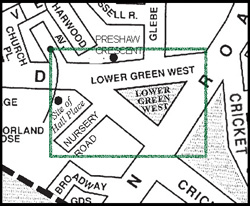
NURSERYROADAV.
PRESHAWCRESCENTLOWERGREENWESTSite ofHall Place
Detail from a modern street map, showing the area covered by this book.
Reproduced by permission of Merton Design Unit, London Borough of Merton
LOWER GREEN WEST
PREFACE
Several of the chapters in this volume originated as separate studies of
buildings or aspects of Mitcham history written as much as a 40 years
ago. Thus, initially, the ‘Foundation of Mitcham Sunday School’ was
submitted as homework whilst I was attending a University of London
extra-mural course on Local History in 1966, and a substantial part of
the chapter dealing with Hall Place was researched for a report on
excavations conducted on the site of the house in 1968 and 1970.
Subsequently both were re-written and, with articles recounting the story
of Mitcham’s stage coaches, the fire brigade and May Day festivities,
were published between 1972 and 1973 by the Merton Borough News
in a series under the general heading of the ‘Merton Story’.
Whilst in no way invalidating these early articles, subsequent research
produced more detail, and my original typescripts became heavily
annotated, and for this reason increasingly difficult for anyone but
myself to interpret. Copies of the newspaper articles (which contained
no reference to sources) were collected by the local library service, but
lacked indices – a shortcoming which made them of limited value to
researchers. The situation was clearly unsatisfactory, and was not
improved by the addition to my files of a considerable body of
information on other buildings which stand around the Green.
The preparation by the London Borough of Merton’s planning services
department in 1994 of a draft ‘Design Guide’ for the Cricket Green
Conservation Area, and the obvious lack of historical information
readily available to those charged with the task, served to emphasise
the need for what I knew to be brought together in one or more volumes,
with indexes.
Eric N Montague – January 2004
Imperial Measures are used throughout this book
1 acre = 4 roods = 160 square rods, poles or perches = 0.4047 hectares
1 yard = 3 feet = 0.9144 metres
1 ton = 20 cwt (hundredweight) = 2240 lb (pounds) = 1.016 tonnes
£1 = 20s (shillings) = 240d (pence)
1 gallon = 4.546 litres
1 horsepower = 745 watts
CONTENTS
INTRODUCTION …………………………………………………………………………….. v
ACKNOWLEDGEMENTS …………………………………………………………….. vii
MAPS AND ILLUSTRATIONS …………………………………………………………. x
1 THE LOWER GREEN …………………………………………………………………. 1
2 352–356 LONDON ROAD, MITCHAM ………………………………………15
3 THE WHITE HART, 350 London Road, ‘The Hooden on the Green’ 19
4 346–348 LONDON ROAD, MITCHAM ………………………………………29
5 THE CRICKETERS, LOWER GREEN ………………………………………..37
6 THE VESTRY HALL………………………………………………………………….43
7 MITCHAM’S FIRE BRIGADE……………………………………………………55
8 VILLAGE FUN AND FESTIVITIES……………………………………………67
9 THE SUNDAY SCHOOL AND NATIONAL SCHOOLS ……………….71
10 HALL PLACE ……………………………………………………………………………85
Introduction and Contemporary Descriptions …………………………………85
The Early Middle Ages ……………………………………………………………….91
The Later Middle Ages………………………………………………………………..94
Tudor Notables, Recusants and Cavaliers ………………………………………99
Hall Place after the Restoration: 1665 – 1673 …………………………….. 103
The Cookes, Heaths, Selbys and Chandlers: 1673 – 1792 ……………. 104
The Worsfolds and Hall Place: 1777–1944 ………………………………… 106
The Last Days of the Old Hall Place ………………………………………….. 106
The New Hall Place ………………………………………………………………….. 111
11 THE HOUSES AROUND LOWER GREEN WEST ……………………. 113
APPENDIX I
THE STRUCTURAL EVOLUTION OF OLD HALL PLACE …….. 123
APPENDIX II
EXCAVATIONS CARRIED OUT ON THE SITE OF HALL PLACE .. 131
NOTES AND REFERENCES ……………………………………………………….. 139
INDEX………………………………………………………………………………………… 157
LOWER GREEN WEST
MAPS AND ILLUSTRATIONS
Lower Green West c.1830. Christmas scene by a local artist ……………. Cover
Detail from the 25-inch to 1 mile O S Map of 1867 ……………………………… ii
Detail from a modern street map, showing the area covered by this book . vii
Detail from the 25-inch to 1 mile O S Map of 1897 ……………………………….. 2
An early photograph of Lower Green West …………………………………………… 9
View across the Green in 1868 …………………………………………………………..12
352–356 London Road ……………………………………………………………………..15
The White Hart and 352 London Road c.1950. ……………………………………19
The White Hart 1974 ………………………………………………………………………..27
Matthews family group c.1910 …………………………………………………………..29
Matthews’ barber’s shop decorated for the coronation of Edward VII …….31
346–348 London Road in 1975 ………………………………………………………….35
The Cricketers in 1868 ……………………………………………………………………..40
The Cricketers c.1975……………………………………………………………………….42
The Cage or watch-house, Lower Green West ……………………………………..45
Vestry Hall c.1910 ……………………………………………………………………………48
Vestry Hall c.1970 ……………………………………………………………………………53
Mitcham Volunteer Fire Brigade and ‘Caesar’ ……………………………………..61
Mitcham Fire Brigade c.1872 …………………………………………………………….63
Derby Day traffic passing the White Hart c.1912 …………………………………66
A May Day group of British School girls, c.1890 …………………………………68
Mitcham Sunday School (later the National Schools) c.1790 …………………72
The clock turret on the former National Schools building ……………………..77
Rear of Hall Place. Canon Wilson’s Jubilee 1908 …………………………………88
The archway on the site of Hall Place …………………………………………………90
Front elevation, Hall Place, c.1825, by Henderson ……………………………….92
‘Bryant’s Corner’, London Road c.1905. ………………………………………….. 114
The 17th-century Vine House, c.1930, now the site of Beadle Court ……. 119
The milestone at the corner of Lower Green West and London Road…….122
Hall Place – sepia drawing by J C Buckler, dated 1827. ………………………129
Plan of excavations in relation to medieval Hall Place and new school….130
Hall Place from the North, c.1825. (Artist unknown)…………………………..133
Mitcham Fire Station, built in 1927, photographed mid-1970s……………..144
Mitcham National Schools c.1900…………………………………………………….146
Vine House and commencement of Church Street c.1870…………………….154
Rear of Hall Place. Canon Wilson’s Jubilee 1908 ……………………………….155
Chapter 1
THE LOWER GREEN
Mitcham’s Lower Green, divided by the London Road to form Lower
Green West and the Cricket Green, is actually a detached portion of
what, in the early Middle Ages, formed a vast expanse of open heathland
separating the village of Mitcham from Beddington and Croydon.
Enclosure of individual plots on the margins of the common lands
obviously took place during the late Middle Ages and Tudor period
but, unlike the adjoining parishes of Croydon, Beddington, Sutton,
Merton and Morden, Mitcham was markedly successful in resisting
the sweeping enclosures which occurred in the 18th and 19th centuries,
and 522 acres of former common land survive as public open space.
Management of the largest portion, some 460 acres in extent and
comprising the major part of Mitcham Common, is under the control
of the Board of Conservators, first appointed in 1891 under the
provisions of the Metropolitan Commons (Mitcham) Supplemental Act
of that year. Five scattered portions, Figges Marsh, the Upper or Fair
Green, Three Kings Piece, Cranmer’s Piece or Cranmer Green, and the
Lower Green, were vested in the Urban District Council of Mitcham
by the powers secured in a private Act passed in 1923. In April 1965
they became the responsibility of the London Borough of Merton.
At the time of the Domesday survey what was soon to evolve as the
ecclesiastical parish of Mitcham was recognised as two separate ‘vills’,
Mitcham and Witford. The latter, which can be equated with Lower
Mitcham, gradually lost its separate identity, although references in
the records to properties being in ‘Wickford’ or ‘Whitford’ continue
until as late as the 17th century. Such is the extraordinary persistence
of folk memory, the Lower Green was still often referred to by local
people as ‘Whitford Green’ in the 19th century.1
Large-scale maps produced by the Ordnance Survey in the mid-19th
century, before urbanisation had obscured the underlying pattern of
land division, suggest that the combined acreages of Lower Green West
and the Cricket Green must once have exceeded the present total of
eight and a half acres. Many of the house plots to the north and south of
the Cricket Green have the appearance of having been created by the
piecemeal enclosure of former portions of the parish waste, quite
LOWER GREEN WEST
Detail from the 25-inch to 1 mile O S Map of 1897
THE LOWER GREEN
LOWER GREEN WEST
possibly by squatters. Park Place, lying between the Cricket Green and
Three Kings Piece, is actually described as ‘Allmannesland’, i.e. all
men’s land, in 14th- and 15th-century records, and the adjoining Canons
estate was presented to the priory of St Mary at Southwark as a gift of
the parish of Mitcham before 1170.2 The Cricketers, Vestry Hall and
fire station stand on land obviously taken from the Lower Green, whilst
it is conceivable that much of the block of property which now includes
the White Hart and the former bank building at the corner of London
Road and Lower Green West occupies an ancient enclosure.
The Lower Green formed part of the tithing of Mitcham granted by
William I to the count of Mortain, as part of the manor of South Lambeth.
Following the battle of Tinchebrai in 1106, when Henry I defeated his
half-brother Robert and the Norman barons who were contesting
Henry’s right to the English throne, the estate seems to have been
confiscated and was granted by the king to Richard de Redvers, earl of
Devon and Wight. After the death in 1216 of Baldwin, the sixth earl,
his widow Margaret married Falkes de Breauté of Fawkes Hall, or
Vauxhall.3 The de Redvers’ manor of South Lambeth, including the
tithing of Mitcham, thus passed temporarily into de Breauté’s hands,
and it is from his tenure that the manor derived the name by which it
came to be known. An inquest post mortem, occasioned by the death in
1262 of Baldwin, the eighth earl of Devon and Wight, confirmed the
latter to have been in possession of lands in Mitcham held as an
appurtenance of the manor of South Lambeth,4 and from the details
given one can calculate the total extent of the de Redvers’ Mitcham
estate to have been some 280 acres.5 Surviving records show properties
within the jurisdiction of Vauxhall to have included a mill at Phipps
Bridge,6 Hall Place and various properties overlooking the Cricket
Green, and also the Park Place estate abutting Commonside West.7 All
must have been held of the manor since the early Middle Ages, and
presumably were once part of the de Redvers’ holding.
By the 14th century lordship of the manor of Vauxhall had reverted to
the Crown, and was held by Edward the Black Prince. In 1363, as the
price of the Papal dispensation needed before he could marry his cousin
Joan, Edward founded a chantry chapel in the crypt of the cathedral
THE LOWER GREEN
church of Christ at Canterbury, the manor being made over to the prior
and convent to guarantee the expense of maintenance.8 Court rolls of
the manor survive from the 15th century, and show that the church was
to prove a worthy guardian of “the Common called the Green”, resisting
enclosure and only sparingly granting permission to the parish officers
to take land for civic purposes. Courts leet and baron were still being
held at the beginning of the 20th century, and the time-honoured writ
of seisin and the swearing of an oath of fealty remained part of the
quaint ritual accompanying the transfer of title and the admission of
new property owners to the tenancy of the manor until a little over 100
1
years ago.
Throughout the Middle Ages the common lands of the parish played
an important role in the economy of the community, and many of the
villagers relied upon the ‘waste’ as a source of fuel and for rough
grazing. As the population grew, pressure on this resource increased,
and with it the need to protect the land against misuse. Amongst the
various measures of control adopted by the prior and convent and, after
the Reformation, the dean and chapter of Canterbury, was the restriction
of pasturage to those tenants of the manor and others with acknowledged
grazing rights. Infringement of the right of common pasture was
regarded very seriously, and unauthorised or straying livestock were
secured in the manorial pound. Release to their owners was conditional
on payment of a fine to the pinder or pound keeper, and persistent
offenders were dealt with by the lord’s steward at the manorial court.
References to the manor pound occur several times in the court rolls of
Vauxhall, one of the earliest being from the Commonwealth period,
when the pound was reported to be “much decayed” – a hint that perhaps
it had fallen into disuse by the early 17th century. The occasion was a
survey of the manor of Vauxhall conducted in 1649 pursuant to one of
Parliament’s early Acts, by which lands held by the dean and chapter
of Canterbury were sequestrated in October of that year. (The cathedral
estates were returned to the Church after the Restoration.)9
The need for a secure pound for use when the occasion demanded seems
to have re-emerged as an issue of some importance towards the end of
the 18th century. The annual Mitcham fair attracted large numbers of
LOWER GREEN WEST
Gypsies and other travellers who, after the fashion of their kind, no
doubt left their horses and other stock to graze on the parish waste with
scant regard for the rights of commoners and copyholders of the manors.
Whether or not the renewed interest in the condition of the pound had
any connection with efforts being made in the early 1770s to suppress
the fair it is difficult to say, but the coincidence of dates suggests the
two might have been linked.10
At the court leet held on 7 November 1775, it was reported by the four
officers from the tithing of Mitcham that the pound belonging to the
manor of Vauxhall was out of repair. Although the court rolls record
the decision that the pound ought to be repaired by the lord of the
manor, nothing seems to have been done, for two years later the
headborough, William Oxtoby, reported to the court that the pound
was still “greatly out of repair”. In 1780 the officers again presented to
the court that the common pound for the “liberty of Mitcham” continued
to be “so out of repair that no estrays or trespassing cattle can be secured
therein to the great loss and damage to the Lords’ Tenants of the said
Manor, and that the pound ought to be repaired by the Lords of the
manor”. A year later, by now clearly becoming exasperated at the lack
of response to their previous presentments, the jurors threatened “a
suit or prosecution against the lords for their neglect” if they failed to
put the pound in “good and sufficient repair” by 1 January 1782. With
their bluff called (if, indeed, it was a bluff) and still with no apparent
satisfaction from the dean and chapter, it was minuted at the court leet
in November 1782 that “Whereas the parish of Mitcham has for the
last five years presented the said pound of the said parish as being
useless and have received no redress”, the frustrated jury “do hereby
firmly make this their presentment that if the pound is not repaired by
the Lords of the Manor within one year the said jury will not keep the
court”. The court met again in November 1783, but no Mitcham business
was conducted, apart from fining the constable, Thomas Chesterman,
£5 for non-attendance. The censure had little effect, for both the
constable and the headborough were fined for non-attendance at the
meeting in 1784. Oliver Baron, a local magistrate who had been a
prominent member of the justices’ committee appointed to suppress
the fair, died in 1786, and thereafter the officers and copyholders would
THE LOWER GREEN
seem to have lost interest not only in resolving their dispute with
Vauxhall, but also in the condition of the pound, and in 1787 it was
reported to have “totally fallen down”.11
After a lapse of nearly 20 years, during which nothing much seems to
have transpired, a new name, that of William Sprules, emerges as pound
keeper in the court leet roll for 1801. This may be of some significance,
for certain landowners were beginning to show interest in the enclosure
of Mitcham Common, and for a while the vestry was to be much
concerned with the proper control of common grazing and the protection
of the rights of pasturage which had been enjoyed for generations by
the copyholders of the various manors. This was, of course, during the
Napoleonic Wars, when there was heightened awareness of the potential
profit to be made from the enclosure and cultivation of marginal land
after improvement by drainage and manuring.
Until the 18th century the pound had been located off Lower Green
West, opposite the present fire station, but it was moved later to a site
on the Green itself, where it is shown on the tithe map of 1847. ‘Old
Billy Sprules’, who died in 1848, was still remembered as the pound
keeper by an elderly witness giving evidence in the case of the
Ecclesiastical Commissioners v. Bridger and others in 1890.12 Within
his memory, he said, cattle straying from the Common had been placed
in the Vauxhall pound – proof that it played a part in the management
of the manorial waste at least until the middle of the 19th century. In
the mid-19th century, presumably after Sprules had retired, Newland,
the landlord of The Cricketers, is said to have acted as pound keeper,
and had charge of the key.13 One can be certain that, with or without
permission, horses and donkeys continued to be left to forage on the
Green from time to time, but the practice of regularly ‘turning out’
stock to graze came to an end well before the close of the century, few
of the remaining copyholders wishing to exercise their common rights.
Loss of common land through illicit enclosure, usually for building
purposes or the extension of adjoining property, became increasingly
frequent as the population expanded, calling for increased vigilance on
the part of the manor’s officers. A grant of enclosure for a purpose
generally recognised as being in the public interest might receive
LOWER GREEN WEST
sanction on receipt of a nominal fee, but it was also recognised that
such grants could be a source of income to the manor, provided no
objections were forthcoming from the tenantry.
Thus the formal consent of the dean and chapter of Canterbury was
obtained by the parish officers in 1765, when the Mitcham Vestry wished
to enclose a plot of land on Lower Green West 12 feet by 20 feet for the
erection of a watch-house or lock-up.14 “Leave and licence” was granted
at “the small acknowledgement of 1d. per annum” on the condition
that the Vestry should be responsible for keeping the building in good
repair. It is understood that their successors, the Urban District Council
of Mitcham, still considered it politic, if not strictly necessary, to seek
the concurrence of the Ecclesiastical Commissioners when the erection
of a new fire station on Lower Green West was under discussion in the
early 1920s.
In the case of the lock-up, which it was considered would be a “publick
Utility”, it had been the unanimous decision of the “parish in Vestry
assembled” that enclosure of a small part of the Green for the purpose
would be justified. There was no such unanimity in 1788 however,
when William Pollard of Park Place, a newcomer to the parish and a
copyholder of Vauxhall, objected to the proposed enclosure of part of
Lower Green West to provide a site for a Sunday School building.
Plans had to be changed, and the school was erected on an alternative
site to the south of the Green, donated by the owner of Hall Place.15
Early in the 19th century, when the enclosure movement was at its
height, there was a real danger that a substantial part of the Green
might have been enclosed. John Middleton, who had been
commissioned by the dean and chapter of Canterbury to conduct a
survey of the waste lands lying within the manor of Vauxhall, reported
in 1806 that “Mitcham Green” was:
“Nearly one third … rough ground; to the enclosure of which no
person would object.
“The other part, of 8 or 10 acres, is a fine turf, in the middle of
the village, on which there is much Cricket playing. This Green
is surrounded by mean houses and Cottages, many of which are
9THE LOWER GREEN THE LOWER GREEN
An early photograph ofLower Green West,
showing the Cricketersand the Cage or lock-up.
Tom Francis Collection,
reproduced by courtesy ofMerton Library Service.
LOWER GREEN WEST
holden of the manor of Fauxhall. What proportion of the
inhabitants would consent to a division of it, I have no means of
Knowing, but this Green is a good sheep pasture, and is the best
feature of the village. A few acres of nice green turf, adjoining
the turnpike road, and in the centre of a village, seems to
contribute its just proportion to the benefit of society.”16
Middleton concluded, after advising the dean and chapter of his
valuation of the land and its mineral rights if it were to be enclosed,
that experience had shown that where commons or greens were
overlooked by persons from London, living in “Genteel houses”
“… to obtain an act of Parliament without opposition cannot be
expected. It would chiefly be from persons who have not any
right of common joined by three or four who have…”
He invited the dean and chapter to consider whether they wished to
incur the expense of soliciting the tenants of the manor for their consents,
and then the charges for presenting a Bill, in the
“… small uncertainty as to whether the acts may be obtained or
not, for the value of their interest in case they should succeed”.
In a letter dated 27 November, John Middleton advised the dean and
chapter that whereas enclosure of commons and wastes was of such
obvious benefit to the nation that it could be taken for granted “that the
Legislature will afford it every facility”, opposition could not be
repressed and was well known to involve the parties concerned in
considerable expense for perhaps little gain. As an alternative, he put
forward the following suggestion:
“Various persons have made many encroachments within the
last eight or ten years, and others have been enclosed for a longer
time, these persons may be induced to accept such grants [of
land, on payment of a sum of money to the lords of the manor] in
preference to being ejected by law. These several grants might
be managed in such a manner as to create a disposition in other
tenants and inhabitants of the manor to solicit for similar
indulgences. Particularly the tenants who compose the Homage
THE LOWER GREEN
Jury may be invited to negotiate with the steward of the manor
for such slips of waste as adjoin, or be conveniently for their
respectively tenements. I think this would induce them to solicit
for grants to be made to themselves on paying for them. It would
also increase the habit they are now in of giving their consent to
other grants, being made to strangers. By a union of making grants
in the first instance, and blinking at encroachments till the parties
can be brought into Court to accept a grant of them, something
considerable may be done in the short time; this system seems to
be calculated to continue for many years, or until all the waste
or Common land belonging to the Manor become enclosed.”
This course of action, devious as it might have been, seems to have
found some favour with the dean and chapter. Middleton’s advice would
certainly appear to have been followed in the case of Elm Lodge and a
group of adjacent properties at the northern corner of the Cricket Green,
where the tithe map shows very clearly that the land must once have
been part of the Green, but none of Lower Green West seems to have
been lost as a result of his suggestion. The reason, one suspects, is that
the opposition which enclosure might have engendered outweighed
any possible financial gain accruing to the manorial coffers.
Old maps show a large pond to the north of Lower Green West, roughly
opposite where the houses of Preshaw Crescent stand today. In 1852 it
measured 200 feet by 50,17 and on a map drawn some eight years earlier
it was marked as ‘King’s Pond’.18 The name was not really of much
significance, and the pond was remembered by one old resident recalling
the 1860s as ‘Hill’s Pond’ – probably after old Billy Hill, the village
beadle and a local builder, whose house stood nearby. In truth, it was
strictly the Ecclesiastical Commissioners’ pond, and it was probably
they, or their predecessors the dean and chapter of Canterbury, who
had given leave for it to be dug in the first place. The sub-soil here is
sand and gravel, and it was most likely to obtain building aggregate
that the excavation was first made. The water-table in this part of
Mitcham was high, and once abandoned the pit would soon have filled
with water, providing a useful amenity for commoners’ cattle and geese.
It was certainly deep in places, and Sir Cato Worsfold, whose early
LOWER GREEN WEST
View across the Green in 1868. The White Hart can be glimpsed behind the right-hand tree and a horse-busstands outside The Cricketers. Reproduced by courtesy of Merton Library Service.
THE LOWER GREEN
childhood was spent at Hall Place opposite, remembered the pond both
for its tiddlers and for its potential as a watery grave, from which he
was more than once retrieved by his nurse.19 The pond survived until
filled in during the 1890s, probably around the time the houses in
Preshaw Crescent were built.
It is apparent from old photographs that 100 years ago Lower Green
West was a largely featureless tract of rough grass, the unsealed roads
as yet lacking kerb stones and merging into the gravel margins of the
Green itself. It was also virtually devoid of trees – in marked contrast
with its appearance today. There was, however, an interesting exception.
According to Tom Francis, in the 1870s and ’80s a group of willows
stood opposite the National Schools which owed its origin to the clothes
posts erected by laundrywomen, exercising what they jokingly referred
to as their ‘line rights’. The posts, of green willow, had taken root in
the moist soil and flourished, but elsewhere on this part of the Green
the natural tendency for wasteland to acquire a cover of scrub and,
given time, secondary woodland, would have been held in check by
the occasional grazing animal. Today’s large trees are the result of
deliberate planting by the Urban District Council after World War I.
As we have observed, with the enactment of the Metropolitan Commons
(Mitcham) Supplemental Act 1891 control of the Lower Green ceased
to be a direct manorial responsibility, and in April 1924, following the
passage of the Mitcham Urban District Council Act of 1923, the local
authority took charge. Like the Urban District Council before it, the
Borough Council of Mitcham, which came into being in 1934, showed
little compunction in building on the Green when it considered use of
the land could be justified as being in the public interest. The Vestry
Hall, erected in 1887 on the site of the village lock-up, but on a
considerably larger parcel of land than that originally sanctioned, had
been doubled in size in 1930 by the building of a large extension to the
rear. The need to provide more accommodation for expanding Borough
Council staff arose again in the early 1940s, and was resolved by the
erection of an ugly outbuilding on yet another portion of Lower Green
West. Although intended to be only a temporary structure, this still
stands today, occupied by the Wandle Industrial Museum.
LOWER GREEN WEST
Crossing Lower Green to the north of the Vestry Hall is a remarkable
survival from the Middle Ages, a footpath leading from an early focus
of settlement in the vicinity of the parish church to what was once the
unenclosed east common field. The old bridle way, over a mile long,
commences at Church Road, traverses both Lower Green West and the
Cricket Green, and as the quaintly named ‘Cold Blows’ leads to
Commonside West. From here it crosses Three Kings Piece, continues
via Lavender Walk to the footbridge erected by the London, Brighton
and South Coast Railway Company in 1868, and reaches Eastfields via
Acacia Road. Few now have any need to walk its whole length, but the
path provides a number of useful short cuts, and is lit and maintained
by Merton Borough Council.
In recent years the need to improve the movement of road traffic has
resulted in road-widening on numerous occasions, invariably at the
expense of the Green. The most damaging in recent times were the
changes carried out in advance of a one-way traffic system which came
into operation in January 1968, necessitating the construction of a road
across the western corner of the Green. A change of political orientation
of the Borough Council at the elections in 1990 led to the cancelling of
a major new relief road, designed to divert heavy through traffic away
from Church Road and the Green, and has regrettably left Lower Green
West as little more than a large roundabout. Hopefully, wiser counsels
will eventually prevail. One can also only trust that further
encroachments will be avoided in the wider interests of the Cricket
Green Conservation Area, which was declared in 1969 with the intention
of preserving the amenities and historical associations of what is still
one of the most attractive corners of Mitcham.
Chapter 2
352–356 LONDON ROAD, MITCHAM
When attempting to compile a history of these three shops, standing
immediately to the south of the former White Hart inn, the local historian
is confronted with problems not uncommon in the case of smaller
commercial properties. Often of nondescript appearance, they have not
normally attracted the attention of photographers as worthy subjects in
their own right, and usually appear only incidentally in Edwardian
postcards and other street scenes to be found amongst the local
illustration collections in public libraries.
In the absence of formalised street numbering the names of the occupants
of such premises are usually difficult to identify from Victorian trade
directories and census returns. In the case of 352–356 London Road a
little progress can be made by combining the few clues contained in the
documentary and photographic record, but this does not amount to much.
Title deeds, usually kept under lock and key and for this reason not always
readily available, can be helpful, but more often than not only recent
changes in ownership are recorded. Even then, information may be lacking
as to the names of the tenants and their occupations. This potential source
has not been explored in the case of these particular properties.
Shops on the sites of 352–356 London Road can be seen on the right of this
early Edwardian postcard.
LOWER GREEN WEST
What has been gleaned from the more readily available sources has
been brought together below. As might perhaps be expected, the history
of the site of Nos. 352–356 London Road is of a succession of small
shops and modest commercial establishments whose appearance and
ultimate demise reflect the changing needs and aspirations of the
community living in the vicinity of the Lower Green. As part of a wider
study dealing with the evolving pattern of retail trade and service
industries in Mitcham their history would conceivably have its own
contribution to make. One feels, however, that what can be recounted
of their fortunes without further research should suffice for the general
reader, and that the inclusion of any more detail would probably make
tedious reading and add little of significance to the general picture.
The earliest evidence of buildings on the site comes from John Rocque’s
map of the Environs of London, surveyed between 1741 and 1745, and
published between 1774 and 1776. Rocque’s representation of the
structures is, unfortunately, highly stylised, and gives no hint of their
nature and purpose. Excavations conducted by the Museum of London
in 1990 in advance of building development at the rear of the three
properties found little of significance predating the 18th century, and
demonstrated, as might have been deduced from the cartographical
evidence, that the area was taken up by yards belonging to the buildings
fronting the high road. Had it been possible to excavate closer to the
road frontage, where the archaeologists suspected there might well be
evidence of medieval occupation, the results could have been more
rewarding.1
From the evidence of the tithe commutation survey of 1846 the building
on the site of Nos. 354/356 was in the possession of a James Taylor.
Early 20th-century photographs,2 when the ground floors were used as
shops, show it to have comprised a two-storey five-bay building
probably originally intended as two dwelling houses, the larger, with
central pedimented doorcase, being the more northerly of the pair.
Sliding boxed-sash first-floor windows set back in their reveals, a plain
tiled roof and a rendered front wall carried to a parapet with concealed
boxed gutter all indicate a mid-18th century date for construction. The
name S Turner was still discernible on the fascia of the smaller unit in
the early 1900s, serving as a reminder that this had been the shop of
352 – 356 LONDON ROAD, MITCHAM
Sam Turner, the village bootmaker who was commissioned to make
cricketing boots for the Australian test team visiting England in the
1880s.3 The adjoining double-fronted shop was shared between Angus
Read, a picture framer and gilder, and William Pugh, a ladies’ and
gentlemen’s tailor. At the side of No. 356 were the double gates of an
access-way leading to the bakehouse of ‘Mitcham Bakery’. A little
before the outbreak of World War I Nos. 354/356 were demolished,
and the buildings still standing were erected in their place.
In the early years of the 20th century it must have seemed likely that
here, in the vicinity of the new Vestry Hall, an administrative and
commercial nucleus serving the emerging township would develop as
the counterpart to the thriving shopping centre already existing around
the Upper Green. Overlooking the Cricket Green there were grouped
two well-established and respectable former coaching inns, plus three
other public houses, the Methodist and Roman Catholic churches, and
a police station. Erection of what could have been the first of an imposing
terrace of shops in The Broadway to the south of the King’s Head was
completed before the end of Victoria’s reign. Around 1900, on the corner
of London Road and Lower Green West, Barclays had erected
Mitcham’s first purpose-built bank, with suites of offices above, and in
1906 the South Metropolitan Electric Tramways opened from Tooting
Broadway to Croydon via Mitcham Fair Green, with a branch to the
Cricket Green.
In style the new buildings which arose on the site of Nos. 354/356
echoed the mood and confidence of the growing community. A full
storey higher than the 18th-century structure which they replaced, the
front façade was in good quality facing brick in two shades of red, with
recessed panels embellishing door and window openings. The
importance of No. 354, which for many years was the offices and
showrooms of the local gas company, was emphasised by its stone-
dressed gable with circular window at attic level. To maintain the overall
unity a wrought-iron balustraded balcony extended along the whole
width of the frontage at first-floor level. Such a building conveyed the
image of reliability and sound business sense to be expected of a
privately owned utility company by its customers and shareholders,
LOWER GREEN WEST
and whereas it has not been verified, a reasonable assumption would
be that redevelopment of the site had been commissioned by either the
Mitcham and Wimbledon Gas Light & Coke Company, or its
successors, the Wandsworth and District Gas Company around the time
that the two companies amalgamated in 1912. During the 1939/45 War
No. 354 was taken over by the administration of the National Fire
Service, but was returned to the gas company after the cessation of
hostilities and became the local offices and showroom of the South
Eastern Gas Board when the industry was nationalised. For many years
No. 356 was occupied by H E Robinson Ltd, one of Mitcham’s principal
private dairies and milk distributors. Both premises had fallen vacant
by the early 1990s, but five years later Nos. 352 and 354 were acquired
as offices by David Blyth, an accountant.
A survey of properties in Mitcham in 1838 lists what is No. 352 as
houses and shops, the occupiers being Richard Saunders and William
Smith, and the present structure (or at least the façade) was almost
certainly standing at this time.4 In style it could be of late 18th- or early
19th-century date, and the first and second floors were clearly intended
for living accommodation. Whether or not the ground floor was a baker’s
shop at this early date is not known, but it was certainly selling bread
and cakes before the outbreak of World War I in 1914, and remained a
baker’s shop until well into the 1930s. The proprietors are understood
to have been Mr and Mrs Card, whose daughter Lilian was to marry
Burn Bullock, the Surrey cricketer and future licensee of what, until it
was renamed in his memory, was the King’s Head inn.5
By the 1950s No. 352 had ceased to be a baker’s, the former early
20th-century shop front having been removed and replaced with a
modern window deemed more appropriate to its new role as a radio
and television shop. In the 1960s and 1970s this was run by DER, the
television and radio rental firm. A decade or so later the premises were
standing vacant and boarded against intruders, whilst proposals for the
erection of flats on the land at the rear were before the local planning
authority. Refurbishment of the interior proceeded concurrently with
the redevelopment of the back land, and in 1995 use of the premises as
offices was under consideration.
Chapter 3
THE WHITE HART, 350 LONDON ROAD
(RENAMED ‘THE HOODEN ON THE GREEN’ IN 2000)
The first documentary evidence for the existence of a White Hart in
Mitcham is provided by an indenture dated 20 February 1609 whereby
Bartholomew Fromond(e) of Cheam sold the property (described as
being in ‘Whitford’, i.e. Lower Mitcham) to Thomas Goldwyer, a
blacksmith.1 Fromond was also the owner of Hall Place, a house of
medieval origins standing at the point where Lower Green West tapers
to meet Church Road. A member of an important recusant family,
heavily fined for their adherence to Roman Catholicism during the reign
of Elizabeth I, he might not have owned the White Hart for long, and
conceivably had inherited it on the death in 1588 of his kinswomen
Elyn Fromond, who may have been the re-married widow of Ralph
Illingworth, the previous owner of Hall Place.
Nothing is known of the appearance of the inn at this time, but it has
been suggested, on stylistic grounds, that parts of the present building
may date from the latter part of the 17th century.2 As it stands today,
The White Hart c.1950. No. 352 London Road can be seen to the left in this
view. Courtesy of Merton Library Service
LOWER GREEN WEST
however, the former White Hart is a typical mid-18th century building
erected, or substantially rebuilt, between May 1749 and March 1750.
Thus, although by virtue of its name the inn could lay claim to a
continuity unrivalled in Mitcham, the structure itself probably has to
concede seniority to the former King’s Head (now the Burn Bullock),
the rear of which can be ascribed, albeit tentatively, to the late 16th or
early 17th century.
Taverns had, of course, existed for centuries before the sale of the White
Hart in 1609, and the earliest known innkeeper in Mitcham is John de
Bockynge. He was named in a transaction in 1318, and is thought to
have had a tavern located somewhere between Figges Marsh and the
Upper Green.3 The first Mitcham inn to have been recorded by name
was the Buck’s Head, a successor to which, misguidedly re-named The
White Lion of Mortimer by the owners after refurbishment in 1990,
still stands overlooking the Upper Green. Until 2000 the White Hart
was thus unique amongst Mitcham’s surviving public houses in being
linked with an inn of the same name standing on the same site nearly
400 years ago. Sadly that link has now been lost.
Strategically this early White Hart was well located for trade, situated
as it was at the meeting point on Whitford Green of roads from
Carshalton, Sutton, Morden and Upper Mitcham. Linking settlements
bearing Saxon names, these roads are of considerable antiquity.
Whitford, or Lower Mitcham, was acknowledged as a separate ‘vill’ at
the time of the Domesday survey, and whereas by the 14th century the
Green and many of the properties surrounding it were either copyhold
or held on customary tenancies under the Black Prince’s manor of
Vauxhall, there is no evidence in the court rolls that the land on which
the White Hart stands ever fell within the jurisdiction of the manor.4
The inference could be that the plot originated as an ancient enclosure,
freehold rights to which were established before the formalisation of
manorial administration following the Norman Conquest.
It is well known that for over 300 years Lower Mitcham Green has
been the village cricket ground, but the name White Hart prompts
speculation on a much older sporting association. The heraldic device
THE WHITE HART
of a white hart was adopted by Richard II, the Black Prince’s son, who
is remembered for the encouragement he gave to the attainment of
proficiency with the long bow, so important when skilled archers were
needed in time of war. Butts were ordered to be set up on village greens
throughout the kingdom, and it takes little imagination to visualise
groups of villagers meeting on the Lower Green to test their skills and,
when the contests were over, retiring to the tavern at the sign of the
White Hart to quench their thirsts with the local brew. Is it possible
that the White Hart dates from these days, and might not men from
Mitcham have been amongst the English bowmen at Agincourt?
Unfortunately there are no records to support the idea, and the burial in
1430 in the nave of Mitcham church of Joan, wife of John Roche,
seneschal or major-domo to Queen Katherine – Henry V’s French-
born consort – is virtually the only link we have locally with the Hundred
Years War and the campaigns of the Plantaganet kings in France.5
Eleven years after purchasing the White Hart from Fromond, Goldwyer
(or Goldwyn, as his name is also spelt) sold the inn to Richard Knepp(e),
the indenture of sale being dated 1 January 1620.1 In a catalogue of
taverns prepared in 1636 only one is recorded at Mitcham, the name of
the innkeeper being given as William Holland.6 This, we may assume,
was the White Hart, still owned by Knepp but then perhaps managed,
or held on a lease, by Holland.
During the Commonwealth, for reasons which are not stated, Richard
Knepp seems to have been in financial straits, and in 1653 he was
forced by order of the courts to sell a house and other property in
Mitcham. The following year circumstances also obliged him to
mortgage the White Hart to Henry Hampson, a rising London merchant
who had taken up residence in the village. In November 1657 title to
the White Hart was sold by Knepp to Robert Cranmer, an East India
merchant recently returned from service in the Near East, who was
then engaged in buying an extensive estate in Mitcham. Assignment of
the mortgage by Hampson to Cranmer took place the following day.
Cranmer’s activities in the property market were to include purchase
of the lordship of the manor of Mitcham Canons and the advowson of
the parish church. As the new squire he would certainly not have been
LOWER GREEN WEST
interested in running the White Hart himself and, like most of his newly
acquired property, it would have been leased to provide an income.
Knepp, it is interesting to note, survived whatever difficulties had beset
him during the Commonwealth and the ensuing Protectorate, and within
a year or so of the Restoration he was in occupation of one of the larger
houses in Mitcham.
Various deeds relating to the White Hart survive from the rest of the
17th century and, from the early 18th century, there are the Cranmer
family accounts, all of which demonstrate that over the ensuing 200
years it was the Cranmers’ practice to lease the White Hart for periods
of around a dozen years at a time. (This arrangement was not brought
to an end until the Cranmer estates were gradually fragmented and
sold off under the Simpsons in the latter half of the 19th century.)
The order books of the Surrey Quarter Sessions for 1661 mention several
applicants for licences to keep common alehouses in Mitcham, but
William Holland is not amongst them. None can be identified
specifically with the White Hart, although on the assumption that this
was the largest inn in the village, George Holloway, a licensee who in
1664 paid tax on a house with five hearths, is a possible candidate.
Richard Thompson with four taxable hearths comes a close second,
whilst the remainder of the alehouses were relatively small, John
Watkins paying tax on three hearths “in the house he occupies”, Thomas
Batts two, John Sympson one and Robert Smyth (who had his licence
revoked by the magistrates later in 1661) one hearth only.7
In the absence of any further licensing magistrates’ records – they seem
not to have survived for Mitcham from much of the 18th and 19th
centuries – our knowledge of the tenure of most of the local hostelries
is sketchy until the regular publication of commercial directories from
the 1820s onwards. Luckily, in the case of the White Hart we are better
served, for the Cranmer family papers at Surrey History Centre are full
of information. Thus we know that in January 1713 Anne Cranmer,
widow of John, the second son of Robert Cranmer, granted an 11-year
lease of the inn to William Busick, another name with which one
becomes familiar when studying the history of Mitcham. At this time
Busick seems also to have been the owner of the house which we know
THE WHITE HART
as the Burn Bullock, then copyhold of the manor of Vauxhall.8 Whether
this was already an inn in the early 17th century has not been established,
but by 1728, when as the King’s Head it was inherited by a Robert
Busick, it was definitely catering for travellers.
In June 1725, following the expiration of William Busick’s lease, a
new 11-year lease of the White Hart was granted by Anne Cranmer’s
son James to Nicholas Joyce. George Platt was next, having negotiated
a 21-year lease from Ladyday 1737 at £15 per annum, clear of taxes,
with an allowance of £10 towards repairs and improvements.9 Platt did
not hold the lease for its full term, and was succeeded by Thomas
Harrison in 1746 at the same rental.
It is from the account book kept meticulously by James Cranmer
between 1740 and 1752 that we are able to glean important information
concerning building work at the White Hart which resulted in the
premises familiar today.9 In 1749 Harrison may have been encountering
some financial difficulty, for a Tyson Chapman paid the quarter’s rent
due at Ladyday 1749 “when the said Chapman and creditors had taken
the sd. Harrison’s Goods and Chattles in execution”. On the other hand,
he may have been arranging finance to meet the cost of the new building.
Whatever the circumstances, they obviously did not affect Cranmer’s
opinion of Harrison’s suitability as a leaseholder, for at Michaelmas
1749 they agreed a new 21-year lease of the inn “with the Cellar, Barne,
Stables, Brewhouse, passage, yard, Gardens and appurtentes … whereby
the sd. Thos. Harrison agrees to lay out £250 in rebuilding that Messuage
within a year over and above the £50 agreed to be layd out by me
towards rebuilding the same besides allowing Him all the Materials of
the Old Messuage”. Cranmer also gives “an account how I paid ffifty
Pounds towards rebuilding the White Hart Inn” from 20 May 1749 to
23 April 1751 on bricks, hollow deals, oak-heart laths, tiles, iron
casements, lead for gutters, pump, pipes, and workmanship connected
therewith, carriage of bricks from the brick yards at Waddon Marsh,
carpenter’s work and surveying, the expenditure on these items being
separately recorded. In addition, Cranmer gave Harrison £5 “for or
towards a new sign and sign post, which he is to lease with the House
as belonging thereto, when he quits the Inn”.
LOWER GREEN WEST
The circumstances which precipitated the rebuilding can only be
conjectured, but a sudden disaster like a fire is a possibility and would
explain Harrison’s apparent financial embarrassment in 1749. Whatever
their cause, Harrison’s difficulties were evidently of short duration, for
after 1749 he paid his rent of £15 per annum regularly at least until
Ladyday 1752, when Cranmer’s account book ends.
In 1972 excavations preceding the erection of a building behind Nos.
346–348 London Road, which are separated from the White Hart only
by the carriageway giving access to the rear of the inn, unearthed a
large quantity of domestic refuse dating from the mid-18th century,
much of it appearing to have come from the White Hart. Bowls and
stems from clay tobacco pipes dating from 1660–1820 were found in
abundance, together with oyster shells. There were also large amounts
of broken glass from wine bottles and glasses, and much broken
earthenware and pottery, including early ‘Queen’s Ware’ dinner plates
and other pieces familiar from the contemporary Wedgwood catalogues.
Probably most interesting of all were the remains of a number of
stoneware tankards, evidently purpose-made for the White Hart, for
several were inscribed with the name of Thomas Harrison. One bore
the date 1759, and with the exception of the clay pipes, the whole
accumulation can be reliably dated to between 1750 and 1770. There
is nothing to associate it with any particular activity at the inn, and it
probably represents the remains of a heap of normal refuse buried in
what at the time was, presumably, a conveniently available plot of vacant
land.10
After Thomas Harrison’s death business at the inn was continued by
his wife for a number of years, and she finds mention in Edwards’
Companion from London to Brighthelmston, which he researched in
about 1789.11 At this time the inn must have been a hive of activity, for
this was the great period of the stage coach. The previous 40 years had
witnessed a vast improvement in the London to Reigate road at the
hands of the turnpike commissioners and, with the established popularity
of Epsom as a racing centre as well as a market town plus, of course,
the growing attractions of Brighton, traffic on the road leading south
through Mitcham increased appreciably.
THE WHITE HART
A possible reason for the rebuilding of the White Hart in 1749 has
been suggested, but the prospect of new custom being attracted by a
fine modern hotel, embellished with a columned portico, might also
have provided an incentive. On the opposite side of the road the King’s
Head was competing for patronage – its impressive three-storeyed front
was erected in about 1760 – and the modernisation of both houses
could be seen as a direct outcome of the growth in road traffic and the
response of two local innkeepers vying with each other for the passing
trade.
Local coaches providing a regular service to and from London were
operating from the White Hart yard before the Napoleonic Wars. At
the same time post horses were said to be always available from the
inn, and chaises could be hired to any part of the kingdom. Towards
the middle of the 19th century, when William Sutton was the innkeeper,
the White Hart Inn or The White Hart Hotel figured regularly in local
directories as a ‘posting house’,12 but the trade was to decline steadily
as the railway network spread gradually across the country. Edward
Mason Davis took over the tenancy or lease held by Sutton in about
1846, his landlords being the trustees of the Cranmer estate,13 and in
the 1851 census return he was shown as the innkeeper, playing host to
several guests and assisted by an ostler, potman and other staff. From
this point on, as the railway network expanded and the popularity of
long distance coach travel declined, the White Hart’s role must have
changed. Until the early years of the 20th century it remained the point
of commencement and return for Samson’s horse-drawn omnibuses,
which provided a service to and from London, but by the outbreak of
war in 1914 the days of the White Hart as a coaching inn were passing
beyond the memory of all but the oldest inhabitants.
Parish vestry minutes of the 18th and 19th centuries show that, in the
absence of a vestry hall or council house, monthly meetings of Mitcham
vestry were held at various local inns, amongst them the White Hart.
Rooms at inns were also used for many other purposes, including
meetings of the village friendly societies – the White Hart, for instance,
was the headquarters of the Inflexible League of Free Masons14 – and
of course for political gatherings. Sir Cato Worsfold, Mitcham’s first
LOWER GREEN WEST
Member of Parliament, elected in 1918 to represent the newly created
Mitcham Division of Surrey, recollected in his memoirs of the village
that
“In olden days the only place for a political meeting, that I ever
remember, was the yard of the White Hart Hotel, and I well recall
the then Members, Sir Henry Peek and Sir Trevor Lawrence,
addressing the electorate from the top of the stone steps that led,
I presume, into the hay loft, with three or four ‘gas flares’, as
they were called in those days, to illuminate the scene.
“On one occasion the opposition had been making abusive
remarks, reflecting grossly on the character of the Army, with
the result that at the next meeting somebody equipped a number
of small boys with substantial cones composed chiefly of sulphur
and gunpowder, with instructions to kindle them if any more
offensive remarks were uttered against the soldiers of the Queen.
We (I must confess it) carried out these instructions faithfully.
But the result, perhaps, went further than the inventor intended,
for dense sulphur fumes not only emptied the yard of our
opponents, but also our friends, the whole of the audience being
compelled to clear out, and the meeting finished on the Cricket
Green.”15
This particular meeting, which probably took place around 1870 (Sir
Henry was member for the Mid-Surrey Division from 1868–1884),
was also described by Tom Francis, who referred to it in the lantern
slide notes he bequeathed Mitcham Library. Eleven years Cato
Worsfold’s junior, he would have been too young to have been there
himself, but had no doubt heard his father tell of the confusion caused.
The cones were probably sulphur candles, of a type used in the
fumigation of houses after cases of infectious disease, and would have
been obtained, no doubt unofficially, from the offices of the local
sanitary authority, which were then located nearby.
The need to hold vestry meetings at local hostelries ended with the
completion of the Vestry Hall on Lower Green West in 1887. The early
20th century was one of rapid development for Mitcham, and after the
THE WHITE HART
end of the 1914/18 war the emerging town gradually acquired many
public buildings, including a cottage hospital, a fire station, a library,
an indoor swimming bath and, of course, many new schools. Between
1925 and 1934 (when Mitcham became a borough) the population
increased by nearly 37,000 to 60,000 and, to meet the obvious need for
a suitable hall for receptions and other functions, assembly rooms were
built as a detached annexe at the rear of the White Hart. These continued
in use for wedding receptions, dances and formal dinners until well
into the 1950s, but then, with a decline in demand, the White Hart
Rooms fell into disuse. Promise of a new lease of life came in January
1982, when the premises were taken over by the John Irvine School of
Dancing, but this was short lived.
Throughout the latter half of the 20th century the White Hart continued
to compete for the lunchtime trade with its near neighbours the Burn
Bullock and The Cricketers, its daytime clientele being largely business
people from offices and factories in the neighbourhood. By the mid1970s
the interior had been made more spacious and attractively
redecorated, and in May 1982 the inn entered a new era in the hands of
The White Hart 1974. Photograph by E N Montague
LOWER GREEN WEST
Roger Stevens, Charrington and Company’s newly installed manager.
Regrettably, confidence then being expressed in the inn’s future was
not borne out by events and late in 1994, its reputation sullied by the
behaviour of some of the patrons it attracted in the evenings, the inn
was closed. By January 1995 the White Hart was included in English
Heritage’s ‘Buildings at Risk’ register, and six months later this Grade
II listed building, the witness of so much of Mitcham’s history, stood
shuttered against intruders whilst Bass Charrington & Co. Ltd., the
owners, considered plans for its rehabilitation and reopening with what
they described as “an enhanced client profile”. Regrettably, the
precautions against vandalism did not prove adequate, and in July 1995
the 18th-century mews block at the rear of the inn was gutted by fire.
A year later, the fine two-storeyed meeting and function hall (built
behind the White Hart in the neo-Georgian style popular in the 1930s)
had been demolished, and the inn, thoroughly refurbished by Bass
Taverns, was re-opened. Much attention was paid by the architects to
the ‘heritage’ of the building, and photographs and notices displayed
inside had a local historical theme. Outside, by way of an inn sign, a
fine replica of a white stag’s head was mounted above the side accessway
leading to the car park. Curiously, the opportunity was lost for claiming
the White Hart as the oldest inn in Mitcham to have been recorded by
name. Unaware of its having changed hands as early as 1609, the owners
put up a new fascia declaring that the inn had been “Established in
1768”, a date which has no significance in the history of the building
or its occupants. Challenged, the architect, John Rogers of Canterbury,
could offer no explanation other than that the date must have been
supplied by the brewers.
By 1998 agent’s boards outside the White Hart announced that the
premises were to be let and, in November 2000, given yet another new
image and renamed the Hooden on the Green, the inn was launched as
a licensed restaurant specialising in “Mexican and traditional feasting”
with “probably the finest Jazz, Blues and Salsa Bar Cafe in Town”.
Chapter 4
346–348 LONDON ROAD, MITCHAM
HOME OF MITCHAM’S STAGE COACHES AND HORSE
BUSES
No fewer than three generations of Mitcham boys had had their hair cut at
C W Matthews’ saloon next to the White Hart when, in 1971, the blinds
were drawn for the last time. Charles William Matthews, artist, barber,
tailor, and amateur photographer, was born in Sevenoaks in 1868. One of
his oil paintings, of his daughter Winnie as a child feeding a kitten, was
published as a birthday card by the Bucentaur Gallery Ltd, of London. He
seems to have painted only in his early life, before the death of his first
wife, and it was photography which in later years became his great passion.1
This interest he shared with his close friend Tom Francis, and several of
the latter’s collection of lantern slides of old Mitcham (now in the possession
of Merton Local Studies Centre) were from photographs taken by him.2
Matthews family group c.1910, showing the rear of 346-348 London Road.
Reproduced by courtesy of Merton Library Service.
LOWER GREEN WEST
Charles Matthews set up his business in Mitcham in the early years of the
20th century, turning No. 348 London Road into a barber’s saloon. The
premises adjoining (No. 346) had been the home and shop of Summerfields,
village tailors and drapers for a century or so, and this business also was
taken over by Matthews. In the ’20s he was joined in the saloon by young
Ernest Parker, another talented amateur artist. Premises nearby had for
years been used by the Whitwell family as a tobacconist-confectioners
shop, but seem to have gone when Barclays Bank on the corner was
extended. The tailoring and drapery business having closed, No. 346 next
became a tobacco and confectionery shop, run by Maud Matthews, who
was Ernest Parker’s sister.3 A few years later a little tea-shop was added to
the establishment. The trio were well-known personalities in Mitcham in
the inter-war period, and after Charles’s death in 1935 the business continued
for a further 35 years in the hands of Maud Matthews and Ernest Parker
until advancing years finally necessitated retirement.
When Charles Matthews adapted the premises to meet his requirements
nearly a century ago they were already very old, with a commercial history
that can be traced back to the middle of the 18th century. An adjacent
building, similar in appearance and vintage, once formed part of the group,
but was demolished to make way for the extended bank. It, too, had a long
history, its last occupiers being the Croydon Rural Sanitary Authority,
who used it as offices, and thereafter the London and Provincial Bank
around the turn of the 19th century.
It is difficult to be certain about the date of erection of the building that
survives, but it is definitely much older than the early 18th-century façade
which now overlooks the Cricket Green. When acquired for use as offices
in 1973 by Thermal Conditioning Ltd, the interior was a warren of quaint
little rooms, passages and staircases. The attic rooms had partition walls
framed with riven oak studding blackened with age, and old mortices in a
heavy timber exposed in the ceiling of a ground floor room gave witness to
its sub-division in the past, or even to the beam having been salvaged from
some ancient structure and re-used. There were also several mysterious
old windows, blocked long ago perhaps to avoid payment of tax, and now
with only their frames visible from the interior. At first-floor level the
boxes of sliding sash windows are set flush with the exterior face of the
wall – an early 18th-century feature, for legislation of 1709, intended to
346-348 LONDON ROAD, MITCHAM
reduce the incidence of fires, stipulated that henceforth in London they
should be inset four inches. In time the edict and the theory behind it
influenced provincial builders, and the old style would only rarely have
persisted in districts like Mitcham, close to the capital, beyond the death of
Queen Anne. The window frames themselves are irregularly spaced and at
different levels – a clear indication that their position was dictated by
structural timbers now hidden from view by the stucco, which is probably
also of 18th-century date. Above the eaves level at the front dormers project
through the plain-tiled roof, their ‘Yorkshire’ sashes sliding horizontally
Charles Matthews’ barber’s shop decorated for the coronation of Edward
VII. Reproduced by courtesy of Merton Library Service.
LOWER GREEN WEST
in a manner once not uncommon in the neighbourhood. The rear elevation,
with its gabled extensions, is in the style of perhaps the 16th century, whilst
the higher ridge line of the main building suggests this may be somewhat
older, and is covering the original structure. Survivals of domestic Tudor
buildings are extremely rare in the Greater London area, and No. 346/8
London Road is certainly unique in Mitcham.4
Interest in the history of the building was aroused in 1972, when excavations
for the foundations of a new structure in what previously had been the
back garden uncovered an accumulation of broken pottery, glassware and
domestic debris dating back to the middle of the 18th century. Broadly
similar assemblages have been found by archaeologists working on other
sites in recent years. Representing the remains of the do-it-yourself refuse
disposal activities of villagers for whom a weekly garbage collection service
was an unimagined luxury, such groups of domestic hardware are often
valuable to the expert, providing, for instance, evidence unobtainable
elsewhere for the distribution of ceramics from known potteries as well as
a means of dating different phases of site occupation or its use. The material
from this particular cache includes sherds from plates and bowls in the
popular Wedgwood ‘Queens Ware’; pieces of several stoneware tankards
inscribed with the name of the licensee of the White Hart, Thomas Harrison,
and in one case the date 1759; tin-glazed blue-on-white earthenware
probably from the Lambeth potteries; combed slipware from Staffordshire,
and heavy glazed red earthenware from the kilns of south-western Surrey
and Fulham. Broken glass includes the remains of numerous wine bottles
and goblets, whilst many of the clay pipe bowls retrieved are not only
closely dateable, but can be ascribed to well-known manufacturers.5
Documentary research enables one to trace the history of the building over
almost 250 years. Long tenure is a feature of the story, one family, the
Holdens, being resident for 70 years and their successors, the Samsons,
occupying the premises for half a century. Both were stage coach and
horse omnibus proprietors, and for approaching 150 years the cobbled
yard to the rear, where the stables and coach houses were located, must
have echoed to the clatter of hoofs and the rumble of iron-tyred wheels.
Land tax records and poor rate books show that in 1783 the house nearest
the White Hart was vacated by James Terry, who had rented it for a number
346-348 LONDON ROAD, MITCHAM
of years from Lewis Woodcock. The new tenant was George Holden, and
it may perhaps have been he who, clearing the back garden of rubbish
discarded by the previous occupiers or dumped there from the adjoining
inn, buried it out of sight. Within a few years George Holden’s Mitcham
and Tooting stage coaches had become a familiar sight on the turnpike
road to London. Setting out from the King’s Head and the White Hart each
morning at 8 and 9 o’clock, they covered the nine miles to the Spread
Eagle in Gracechurch Street within the hour. One coach returned to Mitcham
by 10 a.m., and the other by 3 p.m. The afternoon coach from Mitcham
departed at 4 and returned at 6 p.m. On Sundays the coach left at 6 in the
morning, and was back by 8 a.m.. A further round trip was completed
betwen 5 and 7 in the evening. On Mondays and Saturdays an additional
service was run to the Golden Cross at Charing Cross, leaving at 9 o’clock
and returning at 3 p.m. To these details a contemporary road guide to
Brighton adds that “Mr Holden lets Post Chaises and Coaches to any part
of England”.6 The business was obviously flourishing, and on the
foundations laid by George Holden before the end of the 18th century it
was to continue in the hands of his sons and grandsons until the 1850s.
John Holden, presumably George’s son, rented the house and coach-house
from 1800 until his death in 1819, when tenure passed to Thomas Henry
Holden (born c. 1784) and another George. Intermarriage between village
families was, of course, commonplace, and in 1807 Thomas married
Elizabeth Potter, a daughter of the Mitcham family of physic, or herb,
gardeners. Twenty-seven years later their daughter Rachel united the
families again by her marriage to James Bridger, natural son of James
Moore, the nephew of Benjamin Potter who founded the firm of Potter
and Moore whose lavender was to become world famous.7 It was from
James Moore that for much of the earlier part of the 19th century John, and
subsequently Thomas Holden, rented the coach-house and stables at the
rear of their house and office. The succession of landlords from whom the
family held the premises over a period of 70 years is, in fact a study in
itself, reflecting the fortunes of several prominent members of the village
community. Lewis Woodcock, already mentioned, was probably the son
of Thomas Woodcock, a ‘whitster’ or textile bleacher, who died in 1755,
and grandson of the Heaths, the owners of nearby Hall Place. By the
beginning of the 19th century ownership had been divided between Edward
LOWER GREEN WEST
Tanner Worsfold, the new owner of Hall Place and a maltster by trade, and
James Dempster, a local schoolmaster and proprietor of the Baron House
Academy for Young Gentlemen, at which a number of Queen Victoria’s
future army and naval officers received their preparatory education. When
the Worsfolds fell on hard times during the Napoleonic Wars Moore, one
of the major landowners in the village, acquired their interest in the coach-
house and stables, and on Dempster’s son’s death in 1821 the Holdens
took the opportunity to purchase the house.
Samuel, the last of the Holdens to run the family business, and who seems
to represent the fourth generation, was resident at 4 Commonside West
(The Lawns) at the time of the census in 1841.8 Thomas was still living at
the house next to the White Hart, but ten years later he had been succeeded
by Samuel Holden, his wife Amelia and 12-year-old son Charles.9 A
limestone block, inscribed with the initials C H and F H, can still be seen
from the White Hart yard, re-set in the rear wall of what had been one of
the Holdens’ former coach-houses. Precisely who C H and F H might have
been is not clear, but C H could well stand for young Charles.
These were the great days of the stage coach and the horse; the railways
were not yet a serious competitor on many routes, and the roads of the
kingdom were thronged with a great multitude of vehicles of every
description.10 The practice of commuting to town was well established,
and Holden’s coaches and horse ‘buses ran from the Lower Green Coach
Office at half-hourly intervals in the morning rush hours, starting at 8
o’clock. Samuel Holden’s name appears in local directories until 1855,11
by which time the business had been acquired by Philip Samson, a former
coach driver on the Essex roads. We have no idea what happened to the
Holden family; Samuel can only have been in his forties at the time, but it
may well be that, foreseeing the changes that were to come with the
expansion of the railway network, he astutely sold out while the going was
good.
By the 1850s the London Brighton and South Coast Railway and the
London and South Western Railway Companies were running regular
and fast services between London and the coast through Croydon and
Wimbledon respectively. Long distance coach traffic was in decline and
Samson adapted his business to meet the needs of the time, introducing
346-348 LONDON ROAD, MITCHAM
a ‘bus service from his office which aimed to meet every train stopping
at West Croydon station.12 Even this had to compete with a local line,
opened in 1855 and connecting the two main-line stations via Mitcham.
Despite the competition, Philip Samson seems to have made a living,
and with his three sons, Walter, Frederick and Philip, became a well-
known character in Mitcham during the second half of the 19th century.
Tom Francis knew the family well, and through the medium of his lantern
slides and lecture notes perpetuated the Samsons’ memory long after
their deaths. ‘Phil’ became landlord of the King’s Head and proprietor of
the cab yard at the rear. Walter drove the omnibus to and from London
for many years and Fred, nicknamed ‘Squeaker’ Samson because of his
high-pitched voice, became a veterinary surgeon, with premises at Fair
Green. From 1884, when the village volunteer fire brigade obtained a
new steam-powered fire engine to replace the old hand-operated pump,
Samson’s horses were relied upon to pull the appliance, and Walter (if
not busy driving one of the ‘buses) was one of the drivers. Appropriately,
‘Squeaker’ Samson was the honorary veterinary officer.
346-348 London Road in 1975. From 1783 until 1910 the left-hand house was
the home and office of first the Holdens and later the Samsons, proprietors of
Mitcham’s coaches and horse buses. The stables were at the rear.
LOWER GREEN WEST
Coaches and horses had been Philip Samson’s life, and in his declining
years the old man had a mirror fixed outside his bedroom window so that
he could watch the coming and going of the ‘buses while lying in bed. In
1888, following the death of James Bridger, what had been the old Moore
estate was offered for sale by auction. Included amongst the scattered
properties was Samson’s coach-house and the yard at the rear, with stabling
for 25 horses.13 The outcome of the sale has not been ascertained, but one
assumes the premises were bought by the Samsons. Philip Samson senior
died in 1890, at the age of 73,14 but for a number of years the family
business was continued by Walter and Frederick. The end came in 1910
when, with the extension of the new electric tramways as far as the King’s
Head, horse-drawn omnibuses were no longer viable. Frederick’s veterinary
practice survived for a while, but this, too, disappeared from the Mitcham
scene before the outbreak of war in 1914. The redundant coach yard
eventually became the highways depot of the new Urban District Council.
In 1973 the former Lower Green Coach Office faced a new lease of life,
refurbished to meet the needs of the late 20th century. Appreciating the
old building’s history, Thermal Conditioning Ltd., the new owners, skilfully
adapted the structure to their requirements. The front elevation was
tastefully redecorated, and although the back garden disappeared beneath
a squash court, much of interest was retained to provide offices of unusual
charm and intimacy. By September 1988 346/348 London Road had been
afforded a Grade II listing in recognition of its special architectural and
historic interest, but within five years, the business having failed in the
recession which followed the boom of the 1980s, the building was once
again empty. In October 1994 the vacant premises were included in English
Heritage’s ‘Buildings at Risk’ register, and nine months later a buyer was
still being sought.
By November 1998, after several years of stagnation (and decay) whilst
the Planning Committee debated (and rejected) successive plans submitted
by the owners for conversion into small flats, scaffolding had been erected
as a precursor to work of renovation commencing. Listed building consent
had been granted for the property’s conversion into two houses (its original
configuration) and the squash court behind into three flats. The scaffolding
was removed in January 1999, and the new dwellings were occupied shortly
afterwards.
Chapter 5
THE CRICKETERS, LOWER GREEN
The Cricketers public house and the site it occupies on Mitcham’s Lower
Green have a history which can be traced back to the 18th century, but
there are gaps in our knowledge, particularly of the names of the early
innkeepers. The inn stands on a plot enclosed from the green, which in
itself is interesting, for the land was once part of the waste or common
grazing of the parish. Since this lay within the manor of Vauxhall permission
to enclose and build must have been obtained from the dean and chapter
of Canterbury, the Cathedral having held the lordship of the manor since
the 14th century. The date of the first enclosure, and the circumstances
under which permission was given, might conceivably be discovered by a
search through the manor rolls, but unfortunately these are somewhat
inaccessibly lodged with the archives at Canterbury and, moreover, are
probably in Latin.
Rocque’s map of the environs of London, which he prepared after survey
between the years 1741 and 1745, shows a building on the Lower Green
where the Cricketers now stands, and an area of enclosed land adjoining
it. A clue to the identity of an early occupant of this building was found by
one researcher in the 1980s,1 who noted that at a court baron in 1781 the
copyhold tenure of land held by Bishop Cooper since October 1739 was
declared forfeit as no heir came forward. The land was described as being
one eighth of an acre, with the coachway to the church on the west, the
High Road to the south, and ‘waste’ towards the north and east. No building
is mentioned, and the orientation only roughly approximates to that of the
site of the Cricketers but, given a little latitude, it is possible that this entry
may refer to the original enclosure and whatever buildings stood on it.
Research into the history of hostelries in Mitcham is hampered by the fact
that the early records of the licensing magistrates for this part of Surrey
have not survived. Thus it is not until the latter part of the 18th century,
from when we have the poor rate books and land tax records, that one is
able to ascertain the names of the innkeepers and their landlords.2 In the
closing years of the 18th century, when the inn on the green was in the
ownership of William Pellatt, we have the first mention of it to occur in
print. Edwards, compiling his guide for travellers on the road from London
to ‘Brighthelmston’ in about 1789, passed through Mitcham and noted
LOWER GREEN WEST
that “On the right” (i.e. of the main road to Sutton, to the south of Fair
Green) “is a public house, which stands upon the green; it is the sign of
the Swan, a good-accustomed house, in the occupation of Samuel
Sanders”.3 Edwards may have been using a local abbreviation of the full
name, for in a lease of 1803 the inn is referred to as the “White Swan”.4
To whom one can give credit for the idea of re-naming the old Swan the
Cricketers we shall probably never know, but the inspiration quite obviously
came from its patronage by the cricketing fraternity who, since the early
18th century, had contested the claim of Hambledon to be the cradle of
the national game. When, following the death of Samuel Sanders in 1799,
an inventory of the goods and chattels at the Swan was prepared by his
uncle Richard the contents of the bar were found to include a framed
picture entitled “The Cricketters”, a parcel of old books and scoring slates,
three “crickett” balls, 13 “Crickett and Trap balls”, three “Trap Batts”,
and two “Tressell” tables and benches, whilst in the “Club Room” there
was a “Marquee”.5
The “good-accustomed house” seen by Edwards was a wooden structure,
probably weatherboarded and pantiled after the local fashion, and was
demolished in about 1800.6 Its successor has been described as a red brick
building,7 and seems to have survived until the 1850s. To the right stood
the village cage or lock-up, built in 1765 or 17668 and removed in 1887 to
make way for the new Vestry Hall. Close by the lock-up were the village
stocks, last used in the early 1800s, and behind the inn itself was the
Vauxhall pound, in which straying cattle and horses were kept until
reclaimed by their owners.9 The keys were then held by the innkeeper,
and here we have a possible clue to the origin of the inn, for it could well
have started life as the home of the pinder or poundkeeper, or possibly the
hayward, whose duties included control of the grazing on the manorial
waste. Mitcham vestry minutes record a resolution of October 1770 that
the key of the “watch-house”, as the lock-up was known officially, should
be left in the care of John Bibby for use of the peace officers when wanted.
Bibby might thus have been one of the earliest innkeepers whose name
has come down to us.
The Cricketers was leased to George Tritton, the Wandsworth brewer, in
June 1823. Tritton’s widow sold the Ram brewery in 1831 to Young and
THE CRICKETERS, LOWER GREEN
Bainbridge, who at the same time took over the leases of a number of
local public houses, including the Mitcham Cricketers.10 The first innkeeper
to preside over the newly named Cricketers seems to have been James
Remnant. He was followed by Anthony Newland, and then by George
Watts in the 1840s and early ’50s.11 That the inn was used to provide
overnight accommodation for travellers is confirmed by the census return
of 1851, which recorded two guests staying with Watts and his wife, who
employed resident staff. Watts, known as ‘Dr Watts’ by his regulars who
jokingly asserted that his ale would cure all ills, was probably the last to
hold the licence of the old inn before it was pulled down.
James Drewett, whose memoirs published in the 1920s are a valuable
source of stories about old Mitcham, recalled that when the old Cricketers
was pulled down many neatly-tied packets of Georgian copper pennies
were found secreted above the upper ceiling joists.12 He also described an
old shop which stood next to the inn, kept by a man called Selwood who
sold sweets, eels, whelks etc.. The shop had a shutter to the window which
could be let down on legs to made a convenient counter. Another old
resident, whose recollections of her childhood in the 1840s were published
in 1909, remembered the building as a low cottage, its garden, which
contained an elder tree “so pretty with its white blossoms in spring and
the berries in autumn”, enclosed by a low fence.7
In 1855 a fresh lease for 67 years was granted at a ground rent of £28 per
annum, and within a year or so a new brick and slate-roofed Cricketers
stood overlooking the Green. This was the building the appearance of
which is familiar from old photographs, and which survived until 1940.
Although it occupied much the same ground area as the previous building,
the new Cricketers was almost certainly a more substantial house, and
when auctioned at The Greyhound at Croydon in 1881 was described as
fully licensed, occupying a “capital position” for trade, and “a valuable
asset”. The buyers were Young and Bainbridge.13
The first licensee after rebuilding of whom we have traced record (the
brewery books would no doubt provide a complete list) was Jacob Farmer
Mighell, whose name is given in a local directory of 1870. He was followed
in 1875 by probably the best-known of all the landlords of the Cricketers
– James Southerton, the famous slow bowler who played for Surrey in
LOWER GREEN WEST
The Cricketers in 1868. Reproduced by courtesy of Merton Library Service.
THE CRICKETERS, LOWER GREEN
1854 and 1855 and then again from 1867 until 1874. His success with the
ball was phenomenal, on one memorable occasion, in 1872, helping to
dismiss the MCC first XI for 16 by taking four wickets for five runs.
Southerton’s technique was to bowl round the wicket, making them break,
and occasionally delivering a fast straight ball. At the wicket he was more
controversial – his friends actually accused him of shutting his eyes when
he hit out – but he was still good enough to be selected to play for England
against Australia in the tests of 1873 and 1874. Friendships made on these
tours were renewed when, for a number of years during the latter part of
the 19th century, Mitcham Green was used as a practice ground for visiting
Australian test teams, and many a digger’s thirst was slaked at the Cricketers
bar. Understandably, Southerton was a hero to Mitcham lads. He was
frequently to be seen practising on the Green, and by all accounts was a
friendly fellow, always ready to bowl a few balls to the youngsters when
on his way out to the nets. A little more difficult to believe is the story told
by Tom Francis that it was Southerton’s custom to walk to and from the
Oval for his matches!9 James died in 1880, whilst still at the Cricketers,
and Sarah, his widow, continued to run the inn for some years afterwards.
He was buried in Mitcham churchyard, where his grave is marked with a
tombstone bearing an epitaph suitably recording his prowess on the cricket
field.
Today the view of the cricket pitch from the Cricketers’ windows is
impaired by trees, but a century ago the Green was much more open. The
first floor windows afforded an excellent vantage point, and for many
years the flat roof above the inn’s entrance porch was used by the scorers.
Eventually Mitcham Cricket Club obtained a wheeled hut which was
trundled out at the beginning of a match.
For close on 90 years the Cricketers was a landmark in Lower Mitcham,
intimately associated with cricket and the men who played the game. Then,
after an air raid on 23 September 1940, it fell casualty to the explosion of
a parachute mine dropped by the Luftwaffe. The mine landed between the
inn and what was then the Town Hall, and its delayed action fuse allowed
sufficient time for strengthening the sand-bagging around the municipal
offices. To the anguish of its regulars, the decision was taken by ‘the
powers that be’ that it was the inn that had to be sacrificed in the explosion
that followed soon afterwards. The Cricketers was reduced to a pile of
LOWER GREEN WEST
rubble, and rebuilding during war-time was out of the question. What
remained of the century-old pub was soon cleared away, but within a few
days it was ‘business as usual’, conducted from a small bottle store at the
rear which had somehow escaped the main force of the blast, and was
pressed into use as a temporary bar.
This remained the position for 15 years. Post-war building restrictions
diverted labour and materials to the erection of houses, and delayed
rebuilding the Cricketers until the 1950s. In December 1955 plans were
deposited with Mitcham Borough Council by William G Ingram and Son,
the architects for Young and Company, and two years later the new public
house was open in time for the Christmas trade. The official opening
ceremony was performed on Thursday, 9 January 1958, the first pints
being pulled appropriately by the famous Surrey cricketing twins, Eric
and Alec Bedser. Arthur McIntyre, Jim Laker and Andy Sandham were
amongst those who happily joined in the celebrations, cheering the raising
of a huge laurel wreath to the new Cricketers’ balcony, and toasting the
future of the house in Young’s best brew.14 In the hands of Charles Cromack
the Cricketers quickly regained the popularity of its predecessors, the
crowded bar speaking eloquently of the convivial atmosphere and of the
excellence of the food and drink offered both at the bar and in the first
floor restaurant.
The Cricketers c.1975
Chapter 6
THE VESTRY HALL
Designed by Robert Masters Chart, of whom more shortly, and opened
in Queen Victoria’s Golden Jubilee Year of 1887, the Vestry Hall in
the centre of Mitcham’s Lower Green has become so much part of
the local scene that it rarely attracts comment and may, indeed, be
regarded by some with affection, if only because it is so familiar.
This has not always been the case, and it seems more often to have
been deplored rather than regarded as an embellishment to the Green.
Barrett, the author of Surrey Highways and Byways, writing only seven
years after the Vestry Hall had been completed, exclaimed
“Fronting me now was a terrible building which a poster
informed me was ‘the village town hall’ what ever that might
be! For the moment I had forgotten that Mitcham was a place
where local politics are of vital import and where local party
spirit runs mountains high. Hence I suppose some sort of
‘municipal’ building was needed. But was such extreme
architectural ugliness also an absolute requisite? That red brick
blot has ruined for ever the picturesqueness of Mitcham of
old”.1
Seventy years later Nairn and Pevsner gave expression to the same
revulsion, but with greater restraint and economy of words, referring
to the borough offices in their Buildings of England as
“… the ugly Town Hall (former Vestry Hall) of 1887 on an
island site. Its architect was R M Chart”.2
The 1880s were, of course, the hey-day of the vestries and local boards,
and similarly grandiose and, in many cases, far better conceived halls
and offices are still to be seen in various parts of Greater London
where they were erected as visible symbols both of the growing
importance of local government and the self-esteem of the civic
leaders. Not yet a municipality, for it was still only an administrative
parish looking to the Croydon Rural District Council and other ad
hoc bodies for most of its services, the expanding village of Mitcham
was already aspiring to higher status, to be attained on the creation of
the Urban District in 1915.
LOWER GREEN WEST
Whatever faults it might have in the eyes of the architecturally fastidious,
the new Vestry Hall provided a public assembly room of which the
community felt itself in desperate need. It also afforded accommodation
for the parish officers and, most importantly, space in which that most
necessary item of municipal equipment, the fire engine, could be suitably
housed. It was apparently never questioned that Robert Masters Chart
should be called upon to produce the design, for he was not only a
practising architect and partner in the local firm of Chart, Son and Reading,
but was also the son of Edwin Chart, the vestry clerk. Edwin, a surveyor
by profession, held this office as his father John, builder of the parish
church, had before him. His grandfather, William Chart, had become
vestry clerk in 1762. With such credentials it would in fact have been
almost inconceivable, at a time when nepotism was not in any way
considered improper, for anyone but Robert to have received the
commission. In a way, the Vestry Hall can be seen as a monument to the
Chart family itself, for their record of service in local government is
probably unique.
Robert Masters Chart, who in his turn served as clerk to the Parish Council,
consulting clerk to the Urban District Council during the 1914–18 War,
and surveyor or professional adviser to innumerable local boards, became
charter mayor of Mitcham at the grand old age of 84, when the town
acquired borough status with the grant of a charter of incorporation in
1934. His third son, Lt.-Col. Stephen Chart D S O, continued the tradition,
holding office as clerk to the Urban District Council and subsequently as
town clerk until his retirement shortly after the end of the Second World
War. For the post of chief executive officer to one local authority in its
various guises to have been continuously in the hands of a single family
for close on 200 years must be a record unequalled in Britain.
Part of the site chosen for Mitcham’s new Vestry Hall had already been in
use by the parish for 120 years. On 2 March 1765, after two previous
adjournments, a well-attended vestry meeting held at the King’s Head
unanimously decided that the erection of a ‘watch-house’, which could
also be used as a lock-up or temporary gaol, would be of “publick Utility”,
and agreed that if leave could be obtained from the dean and chapter of
Canterbury, a watch-house should be erected on a piece of their waste
ground (not exceeding 12 feet by 20) in the parish, near to and adjoining
THE VESTRY HALL
the manor pound and fronting the turnpike road to Sutton. Eight months
later the Vestry was informed that “leave and Licence” of the dean and
chapter had been granted at “the small acknowledgement of 1d. p.a” on the
condition that the Vestry be responsible for keeping the building in repair.3
The watch-house erected was a humble single-storeyed affair of red brick
and tile, rectangular in plan and, it would appear, devoid of windows.
Two photographs of it survive,4 but we have no details of the interior,
which may have had some accommodation for the constable or watchman
as well as provision for detaining miscreants pending their arraignment
before the justices, or removal to a more permanent place of detention.
The ‘Cage’, to give the building its usual name, could hardly have served
for anything but temporary confinement, and the amusing story used to
be told of one prisoner escaping during the night by simply removing
some of the roof tiles and climbing out through the rafters.
In front of the cage stood the village stocks. It is not known when they
were first erected, but they obviously played a part in local law
enforcement until the beginning of the 19th century, for it was considered
necessary for them to be renewed early in 1802. This decision quite
The Cage or watch-house, Lower Green West.
From the Tom Francis Collection, courtesy of Merton Library Service.
LOWER GREEN WEST
clearly met with opposition, for in April that year the Vestry was offering
a £10 reward for information concerning persons who had destroyed and
taken away “the newly erected stocks”.3 Punishment by pillory was
abolished in England for all crimes except perjury in 1816,5 by which
time the Mitcham stocks had most likely become redundant. One post,
however, remained standing on the Green until the site was cleared for
the erection of the Vestry Hall. During these works a well is said to have
been uncovered, but no details were recorded and what was left of it is
believed to lie under the pathway to the north of the clock tower.
The Vestry Hall was erected for the sum of £4,000 by E J Burnand, a
builder living in Clifton Road, Wallington. The official opening was on
the afternoon of Wednesday 18 May 1887, the ceremony being performed
in the presence of local dignatories by Mrs H Cosmo Bonsor, the wife of
the Member of Parliament for the Wimbledon Division of Surrey.6 The
event was commemorated in time-honoured fashion by a stone, originally
set in the wall of the entrance lobby beneath the clock tower, where a
flight of stairs led to the public hall on the first floor. The inscription
reads:
“This Vestry Hall
was opened on the 18th Day of May
in the year of Jubilee, 1887, by
Mrs H Cosmo Bonsor
Churchwardens Overseers
J Ferrier Clarke MD Thomas Francis
G P Bidder QC, JP Thomas G Howard
Charles E Innes Henry Hodges
Edwin Chart Vestry Clerk
R M Chart, Architect E J Burnand, Builder”.
On 5 February 1992 the stone was repositioned in the main entrance
lobby of the Vestry Hall and rededicated to mark the conversion of the
ground floor room beneath the clock tower into new accommodation
for various voluntary bodies working in Merton.
As well as holding office as churchwarden Dr Ferrier Clarke of Baron
Lodge was also a highly regarded local physician and surgeon. George
Parker Bidder of Ravensbury Park House was a bencher of Lincoln’s
THE VESTRY HALL
Inn, practising mainly at the Parliamentary Bar. He was president of
the local Liberal party, the first councillor to be returned to represent
Mitcham on the newly created Surrey County Council at the election
held in 1889, and first chairman of Mitcham Parish Council in 1895.
He is particularly to be remembered for leading the successful campaign
to save Mitcham Common as public open space, and is commemorated
by a monument on the Common, erected after his death in 1896 of
injuries received in a street accident. Thomas Francis was the proprietor
of London House, the village department store in Whitford Lane (now
London Road) to the north of the Green, demolished in the 1960s to
make way for Deseret House. His son, Thomas Francis junior, was an
enthusiastic local historian and photographer, whose collection of
lantern slides of Old Mitcham was bequeathed to the Borough. A
selection is shown annually at a lecture arranged by the libraries
department. Thomas Howard was the founder of Howard and Sons, a
firm of builders active in the development of Mitcham in the inter-war
years, and Henry Hodges’ estate agency in Whitford Lane and later St
Marks Road was well-known until the retirement of his son in the 1950s.
All had contributed greatly to the growth of the community, and it is
apt that their names should endure in the building they regarded with
so much pride.
Close by the tablet unveiled by Mrs Cosmo Bonsor in May 1887 was
another memento. This is the brass plate to be seen in the main entrance
to the Vestry Hall where it was re-fixed in 1992, proclaiming that
“The Clock in the Tower adjoining this Hall was
purchased by the surviving members of the
Executive Committee of the original
Mitcham Penny Readings, 1866–73,
from the surplus funds in their hands and
presented by them to the Inhabitants of Mitcham
on the 18th of May, in the Jubilee
Year of 1887.
Joseph Charles Barter, Treasurer,
William Smith, PhD, FSSc.,
William Russell Harwood, Hon. Sec”.
LOWER GREEN WEST
According to Tom Francis7 the dials of the clock are four feet in
diameter, and the figures eight inches long. The height of the tower to
the top of the weather vane is 82 feet. The hour bell was almost 3cwt.,
and the two quarter bells 2½cwt each.
Dr William Smith was the proprietor of a private boarding and day
school for boys, known as Mitcham Lodge College, where the sons of
several of Mitcham’s more affluent shopkeepers and professional people
were sent to receive an education. Tom Francis junior was one of the
pupils, receiving tuition at no cost, so he used to claim, in settlement of
a debt owed his father by Dr Smith. The school house stood a little
back from the London Road, north of Fair Green, and after being
occupied for many years as Harry Gray’s caravan and showmen’s yard
its site was taken in the late 1980s for the construction of Holborn
Way, linking London Road with Western Road.
William Russell Harwood was the local collector of taxes and clerk to
Mitcham School Board, and lived at Glebelands, a late 18th-century
house in Love Lane demolished in 1993 by the Hanover Housing
Association to build housing for the elderly. Of James Barter nothing
is known by the writer, although it seems likely that he was a member
of the family of the same name who had a grocery shop in the village.
The Vestry Hall, seen in an Edwardian postcard c.1910.
THE VESTRY HALL
The Vestry Hall was soon a centre of village life. Here were held the
annual open parish meetings in the days when local passions often ran
high, preceded by the meetings at which the candidates expounded on
their policies to the applause or derision of their audiences. The long
and complex political history of Mitcham deserves a separate study,
and accounts of the debates and sometimes bitter controversies which
were aired in the Vestry Hall will not therefore form part of this brief
history of the building itself. Similarly the rich social history of the
Vestry Hall, always at the heart of village cultural activities, must await
further research. For the time being Tom Francis’s memories of a pre1914
Mitcham must suffice. Here, he recalled, were held temperance
meetings, learned lectures, Band of Hope concerts, bazaars, smoking
concerts and brass band concerts, plays, recitals, performances by the
local ‘minstrel’ troop, socials, badminton matches, and religious
services. Like most villages and small towns a century ago, Mitcham
had largely to provide its own entertainment.
The Vestry Hall has, of course, witnessed many village celebrations,
particularly of royal events in the years prior to the outbreak of the
Great War in 1914. There was Queen Victoria’s Golden Jubilee in 1887,
and her Diamond Jubilee ten years later, the coronations of Edward
VII and George V, and various royal weddings. On these occasions the
Vestry Hall and many of the buildings around the Green were decorated
with flags and bunting. Athletic sports would occupy the centre of the
Green, where the Mitcham Cricket Club played, whilst opposite the
National Schools the maypole was erected. At the coronation of George
V the Green opposite the Police Station was the stage for a grand
Elizabethan pageant, its spendidly costumed participants re-enacting
what were believed to be events from Mitcham’s past, and recalling
some of the village’s renowned inhabitants.
As we have seen, in his design for the Vestry Hall Chart made provision
for the proper accommodation of the parish’s newly acquired fire engine,
‘Caesar’, and for some 30 years the building was the headquarters of
Mitcham’s fire brigade. The engine itself was housed behind double
doors at the far left of the building (now the main entrance to the Vestry
Hall. The public entrance to the ground floor offices, then located
LOWER GREEN WEST
towards the centre of the building, is now bricked up. The alarm
summoning the firemen was struck on the big bell of the clock, day or
night, and in the still hours of the morning, Tom Francis used to assure
the audiences at his Old Mitcham lectures, the summons could be quite
startling. He would conclude by recalling that the bell ceased to strike
and the light behind the clock faces was turned off on the outbreak of
war in September 1939. On 1 March 1945, the black-out having ended,
the clock was illuminated as a trial, and it was officially lit up again on
Monday 23 April the same year.
Some uncertainty attaches to the origin and fate of the bell. In 1888
Potter and Moore’s herbal distillery overlooking Figges Marsh was
demolished, and one of Mitcham’s best-known landmarks vanished
forever. According to Ben Slater, whose memories of Mitcham were
published in 1923,8 the clock and bells, which had hung in the bellcote
above the office and store house, were saved from destruction and
given to the parish authorities by whom they were rehung in the Vestry
Hall tower. Potter and Moore’s clock and bells had once marked the
passage of time for the workers in the physic gardens around the
distillery, and now, if Slater was correct, the bells acquired a new lease
of life, amongst other things calling the volunteer fire-fighters to man
their engine when the need arose. The fate of these historic bells is a
mystery, but they had certainly disappeared from the belfry by 1965,
when the writer made enquiries of the Vestry Hall caretaker and was
assured all the bells were modern. The value of the old bells as scrap
metal would have been considerable, and in all probability they were
sold during the 1939/45 war when sentiment for the past was
understandably somewhat overlain by concern for the immediate future.
With a population of some 33,000 Mitcham had more than doubled in
size between 1900 and 1915, calling for an expansion of local services.
The administrative functions of the old Vestry had become the
responsibility of a new Mitcham Parish Council within the Rural
District of Croydon under the provisions of the Local Government Act
of 1894, but in 1915 the growing township was granted Urban District
status. The Vestry Hall thereupon became the main Urban District
Council offices, but already the accommodation was proving
THE VESTRY HALL
inadequate. After the Armistice, services and staff continued to expand
to meet the needs and growing aspirations of what was fast developing
into a suburb of London, and it was not long before the limitations of
the original Vestry Hall building were all too obvious. Relocation of
the fire brigade in a purpose-built fire station in 1927 brought some
relief, but more elaborate plans were already in preparation, and in
1930 a large extension was completed at the rear of the Vestry Hall
containing not only offices, but also a committee room and a council
chamber on the first floor. The latter served as a courtroom, and
adjoining it was a detention room with barred windows which provided
a functional link with the tiny village lock-up of 1765. The attainment
of borough status and the presentation of the charter was celebrated in
September 1934, by which time the office facilities in the Town Hall,
as the building now became, were again proving inadequate, and staff
were soon being relocated in various premises around the Green,
including Mitcham Court, which was acquired by the corporation in
1936 as a potential site for a new town hall.
In the absence of a district museum, a number of items of archaeological
and general historical interest were at one time to be seen in the Vestry
Hall. The one remaining post from the village stocks, with an iron
staple attached, was kept as a curio for many years, but after being
relegated to the basement it was eventually thrown away. A similar
fate befell the quaint little hand-operated fire pump, dating from the
end of the 18th century. For years it had been a popular item in village
processions and fetes but it, too, was neglected and finally scrapped as
worthless rubbish.
A selection of pottery, weapons and jewellery from the Anglo-Saxon
cemetery for which Mitcham had become well-known in archaeological
circles was also on view at one time in a glass case in a Vestry Hall
corridor. They had been left with the council on loan from the excavator
of the cemetery, Lt. Col. Harold F Bidder, but he was so disgusted, it is
said, at the way in which the exhibits were being treated that he arranged
for their removal to the Fitzwilliam Museum at Cambridge. Regrettably
anyone now interested in seeing similar artefacts from this important
Dark Age site must travel either to the Kingston Museum or the Museum
of London.
LOWER GREEN WEST
In the early 1880s a committee had been established by the vestry to
compile a photographic record of the old Mitcham which, even then,
was beginning to disappear as the process of urbanisation started to
gain momentum. The album of photographs which was the result of
their labours was kept at the Vestry Hall and was available for inspection
on application in the days before the library was opened in 1933.9
Stephen Chart and his father were understandably steeped in the lore
of old Mitcham, and the walls of the corridors, the committee room
and several of the offices were hung with watercolours and oil paintings
of the village. One collection of particular interest, since it portrayed
many of the more picturesque buildings still to be seen in Mitcham in
the 1930s, comprised a group of watercolours by a local artist, Miss
Maberley. Some could still be seen in the former committee room on
the first floor as late as the 1980s, and a few others are understood to
be in the Civic Centre, Morden. Mostly, however, they have vanished.
In what, during the late 1960s, became the senior health visitor’s room
were several pictures from the office of the late Stephen Chart, including
an oil painting by his grandfather, Edwin Chart, of the Tate family’s
house, demolished in about 1828 to provide a site for the almshouses
which still bear their name. Four early 19th-century engravings, framed
in pairs, were of Henry Hoare and his home Mitcham Grove, and of
James Dempster junior and the Baron House Academy of which he
was the master.10 Both houses were demolished during the first half of
the 19th century. After the reorganisation of local government in 1965
an encased map dated 1749 showing the estate of East India merchant
John Manship, lord of the north Mitcham manor of Biggin and
Tamworth, was found in a store cupboard and removed to Mitcham
library for safe keeping, together with an air raid incident map of the
the 1939–45 war and two unidentified oil portraits, probably of 18thcentury
date.11
By 1944 part of the borough treasurer’s department had come to be
housed in a temporary building erected a few years previously on the
Green alongside the main Town Hall. This further erosion of the ancient
common lands of the parish had no doubt been justified in view of the
national emergency, but 50 years later it is still there. Other offices
THE VESTRY HALL
were scattered around the Green, those of the medical officer of health
and the housing manager being at Mitcham Court, where the borough
ambulances were also based. The building inspectors’ office was in
former shop premises to the south of the King’s Head, and the relieving
officer and school attendance officer used a little building in Cranmer
Road.
The London Government Act of 1963 brought an end to Mitcham as
an independent municipality, and on 1 April 1965 the town ceased to
have a separate civic identity, being merged with the Urban District of
Merton and Morden and the Borough of Wimbledon to form the new
London Borough of Merton. The town clerk’s, borough surveyor’s and
treasurer’s staffs were moved from the old Town Hall to other offices
in Wimbledon and Morden, and the public health and school health
departments of the new borough were relocated in what once more
became known as the Vestry Hall. Only one link with the old
The Vestry Hall c.1970. Photograph by the South London Press.
LOWER GREEN WEST
administration was retained, in the form of a rates collection office
beneath the clock tower – a measure prudently adopted by the new
authority to avoid inconvenience to (and to remove a deterrent from)
Mitcham people who might still wish to pay their rates in person and
who would have objected to travelling to Wimbledon to do so.
In 1976 the environmental health officers, who had been occupying
the ground floor rooms at the Vestry Hall, were moved to new offices
provided by the restoration and conversion of Park Place, Commonside
West. The Vestry Hall continued to be used partly by the area health
authority and partly by the borough treasurer’s department, but
increasingly use came to be made of the empty rooms by various
community groups fostered by the council. Eventually the health
authority moved its staff elsewhere and in April 1989, after
refurbishment, the Vestry Hall was formally reopened for community
activities by the mayor and mayoress of the London Borough of Merton,
Councillors Allan and Jan Jones. Within a few years further changes
had taken place and, as we have observed, in February 1992 the stone
commemorating the original opening of the Vestry Hall in 1887 was
repositioned in the entrance lobby of the Vestry Hall, and rededicated
by the mayor, Councillor Peter McCabe, to mark the conversion of the
old cash office into new accommodation for the expanded Merton
voluntary sector.
Today in the lobby of the Vestry Hall one can also see the brass plate
from the former tower vestibule recording the contribution made by
Mitcham Penny Readings to the purchase of the clock. In addition.
there is a tablet to the memory of Dr Henry Love, a member of the
Urban District Council of Mitcham from 1915–1934 and, nearby, a
bronze plaque in memory of Dr Albert Thomas Till, MD, DPH, the
borough medical officer of health, who was killed by enemy action in
the autumn of 1940 when his house in Mitcham Park was destroyed
during an air raid.
Chapter 7
MITCHAM’S FIRE BRIGADE
To compare the Mitcham we know today with the village of a century ago,
then a somewhat ‘down-market’ backwater of rural Surrey, is a fascinating
study in suburban evolution. It also provides illuminating glimpses of a
community in which there existed a degree of ‘grass roots’ involvement in
local affairs contrasting sharply with the modern readiness to abdicate
responsibility for the provision of essential services to members and salaried
officers of what can often be a remote and impersonal elected authority or
appointed quango.
The changes that have come about in public attitudes and in community
involvement over the last 100 years are nowhere better illustrated than in
the fire service, at one time amateur, parochial and often ludicrously
ineffective, and now highly professional and organised with superb
efficiency on a London-wide basis.
The Mitcham ‘fire brigade’ of the 1870s and 1880s is now well beyond
the memory of even the oldest inhabitants. Its exploits have, however,
passed into local folklore, largely thanks to a series of articles on old
Mitcham, edited by Lt Colonel Harold Bidder and published 80 years
ago.1 The parish’s first appliance, a manually-operated pump, was replaced
in 1884 by a steam-operated fire engine but the old pump, known
affectionately, if irreverently, as ‘the village squirt’, a museum piece sadly
without the protection of a museum, survived the inter-war years only to
suffer the fate of being thoughtlessly discarded as useless in a fit of municipal
spring-cleaning.
In its prime, this “very important, if ancient, appurtenance of our local
government”, as it was once referred to by Sir Cato Worsfold, Mitcham’s
first member of Parliament,2 was stored in the ‘engine house’ adjoining
the lock-up on Lower Green West. Both buildings dated from the mid18th
century, and a quaintly-worded minute of the Vestry in 1776 records
the decision to erect a “proper house for the Engine at the back-side of the
Watchhouse”. Sanction to take a small portion of the village green for this
purpose was, quite properly, obtained from the lord of the manor – a nicety
which it was no longer necessary to observe when, in 1927, a far larger
plot on the Green was permanently lost as public open space when the
Urban District Council of Mitcham decided to erect the present fire station.
LOWER GREEN WEST
Displayed on the doors of the old engine house were written
instructions for obtaining the keys, and the scale of pay for those
assisting at a fire. The pump was not, of course, to be used by any
unauthorised person, and this vital item of parish property was in the
official custody of the beadle. The last holder of this illustrious office,
William Hill, lived at Vine House, overlooking Lower Green West,
on a site now occupied by police housing. The actual muscle for
working the pump was frequently supplied by senior boys released
from the National School, and although their youthful energy was
invaluable in dragging the pump to the fire, it is said that more often
than not the flames were out on their arrival.
Once at the scene of the fire, assuming there was still work to do,
difficulties were far from over, for it was no easy matter to persuade
the appliance to work. Sir Cato Worsfold, recalling the last days of
the pump before it was retired, wrote
“There certainly was no undignified haste when our fire engine
went into action, chiefly due to its being worn out; and at last
debility in its internal organs led to its inability to send out
water alone for extinguishing fires. Blended with a sufficiency
of mud, however, a stream could be sent some little distance
on to a conflagration, and fortunately this proved very
efficacious when the Heywood oil-cloth works caught fire.
Water alone would have extended the flames of blazing oil,
and so the peculiarity of our fire engine proved invaluable.
With the end of a hose planted firmly in a ditch of particularly
juicy mud, streams of a rich consistency were poured on to the
burning floors of the factory, and the flaming oil subsided.”2
According to Sir Cato, this was the last important performance in
public of the manual pump, although it was regularly brought out of
retirement to be given a place of honour in village fetes and
processions.
To our sophisticated minds the village fire brigade may be reminiscent
of an old-time movie, but to the residents of Mitcham, and in particular
those with property at risk, it was no laughing matter. The general
feeling of insecurity engendered amongst the more wealthy inhabitants
MITCHAM’S FIRE BRIGADE
was such that a circular letter was dispatched in November 1883 over
the names of Caesar Czarnikow of Mitcham Court and W S Reading,
“late Fireman, Sutton Fire Brigade”. It declared that
“In consequence of the very disastrous Fire at Messrs. Creases’
Factory last Tuesday, at which the utterly unprotected state of
property in our Village was exemplified, it has been thought
necessary to take measures for the better security from Fire for
the future.
“With this view, it is proposed to convene a Meeting of the owners
of property, and others, at the Committee Room, ‘Cricketer’s’
Inn, at 8.30 o’clock p.m. on Wednesday, the 21st instant, to
consider the advisability of forming a Volunteer Fire Brigade
etc etc., at which your attendance is requested”.
The acquisition of a modern pump was at the heart of their proposals
and, as we shall see, the urgency of the appeal was matched by the
enthusiasm of the response, unquenched by the efforts of those who,
like a correspondent of the Sutton Advertiser, sounded a note of caution
against over-reaction:
“That Mitcham ought to have a good fire engine there can be no
manner of doubt, but I do not think the inhabitants would be
wise if they rushed headlong into the expense of a steamer. That
luxury should be reserved for larger places, where fires are more
numerous. During the past three years and a half there have been
only six outbreaks in the parish, and most of these were so
insignificant as scarcely to merit the name of a fire. In June,
1880, there was one at a cowshed at Cedar-cottage. In November
of the same year there was a slight fire at the Chemical Works,
and a little bit of a blaze at Messrs. Hayward’s factory. which
was extinguished with a few buckets of water. In August, 1882,
a conflagration broke out at Messrs. Rolls and Round’s varnish
factory, when a good deal of damage was done. In September,
1882, there was a fire at Singlegate, when a cowshed and some
hay and straw were burnt. Lastly, we have the recent fire at the
varnish factory.
LOWER GREEN WEST
“I think most of your Mitcham readers will agree with me that it
is not necessary to employ a steamer to put out fires in cowsheds.
What is really wanted is an engine that will extinguish a small
conflagration and keep a large one under until effective assistance
arrives from parishes that can afford to be better equipped.
Something besides the first cost has to be considered before the
purchase of a steamer is decided upon. It is a heavier machine to
horse, and it requires skilled labour to work it. It cannot be locked
up in a shed and left alone in its glory until occasion arises for its
services. The village certainly needs some sort of provision, but
it might stop short of a steamer.”
Mitcham was not a place where hundreds of pounds were likely to be
subscribed readily. The recent fires had, however, convinced the
inhabitants that some better safeguard was needed than the old parish
engine, and by the liberality of some of the residents, prominent amongst
whom was Caesar Czarnikov, a sufficient sum was subscribed to make
possible the purchase of a steam fire engine. By January 1884 the sum
of £278 in donations and subscriptions had been guaranteed. The money
was raised by donations and subscriptions (the list reads like a local
Who’s Who), and the unpaid volunteer firemen, not to be outdone, bought
their own uniforms and personal equipment.
Within less than two months of the meeting, Mitcham found itself the
proud possessor of a gleaming Merryweather ‘No. 1 Volunteer’ steam
engine purchased, nearly new, for £325. The cost of the appliance was
a considerable reduction upon £400, the normal cost of a new engine,
since this one had been used three or four times. Of about one ton in
weight, it was of the horizontal type, of 25 horsepower, and was
calculated to raise 100 lb of steam from cold water in ten minutes and
to be able to deliver 260 gallons of water per minute. It was also supplied
with suction hose, stand pipe, delivery hose – indeed, everything
necessary for its purpose.
The event was one deserving commemoration, for a mere seven weeks
had elapsed since the scheme was taken in hand. and on a cold day in
January 1884 the brigade paraded their new engine through the village,
receiving public acclaim normally reserved for visiting royalty. Mitcham
MITCHAM’S FIRE BRIGADE
had acquired more than a spendid modern fire appliance; it possessed
an important status symbol and had taken a significant step on the
upward path of civic pride.
Today, the arrival of a new fire appliance at Mitcham would pass
unnoticed by the general public and would certainly not be considered
worth reporting in the local press. A century ago it was an event that
few of Mitcham’s 9,000 or so inhabitants wished to miss, and the
occasion was turned into a public holiday, with the whole village en
fête. A delightful report on the day’s ceremonies appeared in the Sutton
Advertiser of January 1884, from which the following account is culled:
January is not a month which in the northern hemisphere would be
selected as the most suitable for processions through the streets and for
displays of bunting, but as the engine had been bought and had arrived
in the village it was considered desirable that the ceremony of induction
should be performed as speedily as possible without regard to the season.
Even the walls had been made to speak a welcome to the newcomer,
placards wishing “Success to the Mitcham Fire Engine” having been
liberally beplastered everywhere. Wednesday was the day fixed for the
grand and gorgeous ceremony, and visitors to what was usually a quiet
neighbourhood must have been a good deal astonished to find many of
the principal shops tastefully decorated, and the streets as gay with
flags as the fog permitted.
It had been arranged that the procession should be formed at the Swan
Inn near Figges Marsh, and then parade the parish. Accordingly, a little
before two o’clock visiting detachments from neighbouring localities
made their way to the place of meeting, the first to arrive being one of
the Wimbledon brigade’s two steam pumps, drawn by four horses.
Others followed, and soon after the appointed hour the column started
on its way, headed by Mr Czarnikov on horseback, attired in a uniform
befitting the captain of the new Mitcham Brigade. Then came the band
of the Holborn Industrial Schools [the great orphanage which stood on
the site of Monarch Parade] and next the new volunteer brigade upon
their handsome steamer, drawn by a pair of omnibus horses from the
Samsons’ stables at the back of the White Hart. The steam engine of
the Sutton Local Board followed, then the Carshalton contingent. Next
LOWER GREEN WEST
came members of the Sutton Volunteer Brigade, followed by the
Wimbledon men on their engine, and lastly the old parish manual pump
of Mitcham, drawn by two dirty white ponies, unkempt and ungroomed.
The local press commented that it was rather hard to treat this venerable
little machine so contemptuously, for in its day it probably received as
much admiration as was shown that Wednesday towards the more
imposing Merryweather steamer. Matters were not improved by the
ponies being of contrasting sizes and apparently of different dispositions,
as they did not seem to agree upon the direction they wished to go, and
being driven in tandem, each had a good opportunity to try to have his
own way. The progress of the vehicle was accompanied by ironical
cheering from the children whom, the reporter observed, Mitcham
seemed to produce in abundance. The schools had been let loose in
honour of the occasion, and boys and girls of various sizes and in various
stages of cleanliness were swarming everywhere.
After traversing the principal streets of the parish, and giving the
inhabitants time to admire the decorations put up by the shopkeepers
and other tradesmen, the procession proceeded to the Lower Green,
and halted in front of Mr Czarnikov’s residence, Mitcham Court. Here
the crowning ceremony of the day was to be performed. The whole
population of Mitcham seemed to have mustered at this spot, one old
resident recalling the impression that more people were about than on
Derby Day, normally the great gala day for the village. The new engine
was driven at a gallop around the Green, returning to its station with a
dense cloud of smoke issuing from the chimney, and in a short time
steam was made. A bottle of champagne was placed on the engine, and
Miss Czarnikov, breaking the bottle (most appropriately) with a
fireman’s axe, offered it up as a sacrifice to the success of the machine.
The ceremony was gracefully performed, and ‘Caesar’, the name by
which she baptised the engine, acknowledged the compliment by
immediately sending a jet of water upon the Green. Its power was then
tested at some length, and the result appeared to be satisfactory to the
experts around. With a sufficient supply of water (an important
consideration in a village not yet fully ‘on the mains’), it was felt there
need be no fear that any room of any dwelling in Mitcham would be
above the reach of the stream of water the engine could raise. After
MITCHAM’S FIRE BRIGADE
working it up to a pressure of 100 lb the trial was brought to a close.
The completion of the baptismal ceremony was followed by cheers for
the lady by whom it had been performed, and for others concerned.
The members of the Mitcham brigade and the visiting detachments
were afterwards entertained by Mr Czarnikov in Mitcham Court.
The new brigade was composed of many whose family names are still
familiar in Mitcham. Others, less well known to the present generation.
but ‘leading lights’ in their own times, appear regularly in the annals of
the village. Julius Caesar Czarnikow, the captain, was a wealthy sugar
broker in the City and had come to live in Mitcham in 1869; Robert
Masters Chart, the brigade superintendent, was surveyor to the Croydon
Rural Sanitary Authority and after long service in local government
was destined, as mentioned earlier, to become the first mayor of
Mitcham in 1934, when in his eighties. W S Reading was the engineer,
and his assistant, W Jenner, an ironmonger with premises in Upper
Mitcham. Frederick Samson FRCVS, the village veterinary surgeon,
and honorary vet. to the brigade, was a driver and, as might have been
expected, was skilled in the handling of horses. His brother, Walter,
Mitcham Volunteer Fire Brigade and ‘Caesar’, their Merryweather steamer.
Reproduced by courtesy of Merton Library Service.
LOWER GREEN WEST
who also acted as driver, was the proprietor, after their father’s death in
1890, of Mitcham’s horse buses and provided the animals to draw the
engine. The brigade’s honorary medical officer was local GP, Dr Henry
Love. The rest of the brigade comprised Messrs. T P Harvey, R Ellis of
Elm Lodge, Lower Green East, A R Harwood (later secretary of the
local Conservative Association), C Hallard of Lower Green, W Baxter
a grocer, W Southerton, landlord of The Cricketers, A Clarke, W Turner,
the ‘call boy’, whose father Samuel was a boot maker and repairer, and
W L Waters.3
In January 1885, on the first anniversary of the formation of the Mitcham
Volunteer Brigade, a meeting was held in the Church Rooms on Lower
Green West. Mr Czarnikov was in the chair. Primarily called for the
presentation and reception of the annual balance sheet, prepared by R
M Chart, the honorary treasurer, the proceedings were enlivened by a
concert of songs and violin and piano solos. Both programme and
balance sheet survive, the list of donors and subscribers on the back of
the latter reading like a village Debrett, from which one can deduce the
social status to which each benefactor aspired by the extent of his or
her generosity. The accounts showed that the purchase price of the engine
had been met in full. It has to be said that the readiness of so many
worthy citizens to assist in safeguarding the financial viability of the
enterprise does not seem to have been matched by the Samson brothers,
who in the first year had charged £31 10s 0d for the hire of their horses.
Around 1886 the old engine house was demolished and the site used,
with additional land, for the erection of the Vestry Hall, which was
opened the following year. Chart, the architect, made provision for
housing the fire engine within the new building, double half-glazed
doors being hung in the wider arched opening which still survives as
the main public entrance to the Vestry Hall. Within the clock tower was
the alarm bell used to call the volunteers to man the engine when an
emergency arose.
The Merryweather steamer served Mitcham for 27 years before being
sold to Guyatt, a sand merchant who then occupied premises in Church
Road. These were later to become the Corporation Highways Depot,
and are now covered by the Morland Close housing estate erected in
MITCHAM’S FIRE BRIGADE
the 1980s. Once more the Mitcham fire service took a significant step
forward, this time into the era of the internal combustion engine. Their
new appliance, also by Merryweather, was powered by a 55 hp Daimler
engine and driven by a chain drive. It carried a 30–foot extending ladder
and a rear-mounted Hatfield pump capable of delivering 400 gallons
per minute. The vehicle itself had wooden wheels with solid rubber
tyres. There was no windscreen, and a somewhat unreliable electric
lamp powered by a battery was supplemented by oil lamps. Despite its
weight, it was only fitted with rear wheel brakes, and was a ‘brute’ to
drive. Nevertheless, the advance over the old horse-drawn steamer was
tremendous.
For many years the Mitcham Volunteer Brigade continued to receive
the loyal and enthusiastic support of the village. The men and their
machines (for the parish manual pump was not forgotten) were an
essential element in the processions which were such a feature of village
life in the days before the 1914/18 war, and their success in annual
contests with other brigades won general acclaim. In 1919 the newly-
formed Urban District Council took the decision to appoint Mitcham’s
first salaried fire officer, and in January 1920 Superintendent Albert G
Mitcham Fire Brigade c.1872. The vehicle to the rear was based at Colliers
Wood. Reproduced by courtesy of Merton Library Service.
LOWER GREEN WEST
Wells commenced duties. At this time the brigade consisted of 20
volunteer officers and men on a ‘retained’ basis, with a second, manual,
pump based at the Colliers Wood sub-station. Within a few years of
Wells’ appointment the Colliers Wood manual was replaced with a
Dennis motor firetender equipped with a 250-gallon Hatfield pump
and a 50–foot fire escape.
Wells and his colleagues formed the nucleus of what ultimately became
a wholly professional force, but the men on whom the district was to
continue to rely for many years were the volunteers, whose pride in
their efficiency knew no bounds, and to each of whom an outbreak of
fire seems to have presented a personal challenge as much as a call to
duty. By the 1920s the men were summoned by a siren on the top of the
Vestry Hall during the day, but by house calls at night.3 In 1927 the
new fire station erected by the Urban District Council on the Lower
Green was opened, and the 360-gallon Hatfield motor pump, which
until then had been housed in the Vestry Hall, was moved together
with the fire officers, to greatly improved accommodation.
With the phenomenal growth of Mitcham as a London suburb in the
1920s, and the development of several large factory estates, there
emerged the need for a fully-professional fire service and the nature of
the brigade changed, auxiliary firemen trained in Mitcham being
transferred to the permanent staff in increasing numbers as they
qualified. By the time Mitcham achieved Borough status in 1934 the
town could justifiably be proud of its fire brigade and the service
rendered by Chief Officer Wells, who after 26 years in fire-fighting
(14 of them in Mitcham), held the position of chairman both of the
Surrey County Fire Brigade and the Surrey District Fire Brigades’
Association.4
During the 1939/45 War, when it was augmented by the Auxiliary Fire
Service (the AFS), the Mitcham Brigade acquitted itself with honour.
In Under Fire: The Blitz Remembered, a booklet produced by the
London Fire and Civil Defence Authority in memory of the many
hundreds of men and women in the London Fire Service who lost their
lives during the War, six men from Mitcham – Leading Fireman A H
Spiller and Firemen Cecil A Eliman, George H Holloway, Harold C
MITCHAM’S FIRE BRIGADE
Parker, Edward E G Pepper and Ernest F Robinson – are listed amongst
those from the Greater London Area who lost their lives in the ‘Blitz’
proper between 7 September 1940 and 31 May 1941.
From 1941 the Mitcham Fire Brigade and the AFS were part of the
National Fire Service, but further reorganisation followed shortly after
the cessation of hostilities, with responsibility for the fire service outside
London transferred to Surrey County Council on 1 April 1948. The
London Fire Brigade, which had come into being in 1866 when the
Metropolitan Board of Works was made responsible for fire-fighting
in the capital, resumed its former role, covering the London County
Council area. In 1965, when the Greater London Council was formed
under the London Government Act of 1963, Surrey transferred the
Mitcham unit to the London Fire Brigade, whose duties were extended
to embrace the whole of Greater London. The fire service today is
under the control of the London Fire and Civil Defence Authority, which
took over responsibility from the Greater London Council with effect
from 1 April 1986.
In September 1972 it was announced in the local press that at a cost of
£75,000 the Greater London Council proposed re-locating Mitcham
fire station from its “cramped and out-dated” accommodation on Lower
Green West to Goat Road, on land overlooking Mill Green at Beddington
Corner. The Mitcham station had no drill yard and nowhere to wash
the engine, and the facilities for the men were not good. Negotiations
were in progress with Wates Ltd for the site of Golden Terrace, a row
of late Victorian cottages already scheduled for demolition and, provided
all went well, it was intended the new station would be functional by
1973. Although concern was being expressed about the future of the
tenants of the cottages, many of whom had lived there for most of their
lives, the proposals were generally welcomed, the firemen in particular,
it was said, being “delighted”. In the event the scheme was dropped.
Golden Terrace was demolished, and the site cleared, but Mitcham’s
fire station still stands on the Lower Green, providing a rather pleasant
memento of those days 75 years ago when, for many who then
remembered Mitcham as a Surrey village, the building marked a
significant stage in the progress of the emerging township towards full
municipal status.
LOWER GREEN WEST
Derby Day traffic passing the White Hart c.1912.
Reproduced by courtesy of Merton Library Service.
Chapter 8
VILLAGE FUN AND FESTIVITIES
Cricket may now dominate the games played on the eastern section of
Lower Green, but for centuries the nine acres of ‘parish waste’ either
side of the London Road have also served as the focal point of village
recreation and celebrations. Until the early 19th century Lower Green
West in particular seems to have been used very much as a conventional
village green, even boasting a duck pond and a pair of stocks.
Until the reform of local government late in the 19th century Mitcham
remained in many ways a medieval village, ruled by the local gentry. A
substantial proportion of the working population was tied to the land
by force of economic circumstances or lack of opportunity, and in many
instances the field structure and pattern of land tenure had changed
little since the Middle Ages. The stewards of the three manors of
Ravensbury, Vauxhall, and Biggin and Tamworth still held courts baron,
at which fealty to their respective lords was sworn by incoming tenants
before a ‘homage’ or jury. Admission fines and heriots were still
demanded by the lords of the manors, whilst copyholders steadfastly
defended their rights to turn out their cattle on the Common, or to collect
turf and wood for fuel. To the east and west of the village centre the
open fields remained largely unenclosed and were cultivated in typical
medieval strips or ‘lands’, grouped in furlongs and held by numerous
farmers and smallholders on a variety of tenures. Crops in these fields
were mainly medicinal and aromatic herbs which, as it happened, lent
themselves to cultivation in long rows, thus perpetuating the retention
of an ancient field system which, elsewhere in the country, had long
since given way to more rational patterns of land management.
It is hardly surprising that in a community so rooted in its past old
customs should die hard. Both secular and agricultural years were tied
inescapably to the cycle of the seasons, conveniently punctuated by
the movable feasts of the Christian church and the far older pagan
festivals of Spring and Autumn. Since the early Middle Ages the needs
of communal agriculture had dictated a time for ploughing and a time
for excluding cattle from the sown fields. By common assent, the
aftermath in the open fields could not be gleaned or grazed until the
last crops had been lifted or the harvest gathered.
LOWER GREEN WEST
As late as the 19th century the election of the parish officers on Easter
Sunday and the beating of the bounds at Ascensiontide were still as
much part of village life as bonfire night on 5 November. Woven into
this background there survived ancient folk customs often rendered
meaningless to the participants by the passage of time.
Each year thus had its sequence of events, described already in The
Cricket Green.1 The annual crowning of the May Queen, shorn of its
primitive undertones of nature worship and fertility symbolism – it is,
in reality, an aspect of the old pagan festival of Beltane – is even today
perpetuated as a pretty ceremony on the Green, giving pleasure to
children, parents and onlookers alike. The ceremony finds no mention
in the memoirs of old residents recalling their childhood in Mitcham in
the mid-19th century and was a late-Victorian revival. A maypole on
the Upper Green was mentioned in an 18th-century guide, and would
seem to have been a permanent feature of the village landscape,2 but of
the rituals that attached to it, nothing has come down to us. There are,
however, two early photographs of girls in their May dresses – one of
a group dancing round a maypole on the Lower Green, and the other of
A May Day group of girls from the school in Western Road, c.1890.
Tom Francis Collection, reproduced by courtesy of Merton Library Service.
VILLAGE FUN AND FESTIVITIES
girls decorously arranged for the camera outside the British and Foreign
Schools in Western Road.
More robust and earthy, the May Day revels of the local chimney-
sweeps and butchers are by chance well recorded.3 A sweep, as all
brides know, brings luck at a wedding, but how many would blush to
know that he represents the May King, symbol of male sexuality in
pagan mythology? A century and a half ago, in what must have been a
grotesque procession, the butchers and chimney sweeps, with a ‘Jack-
in-the-Green’ or May King, cavorted around the village, the sweeps
knocking their brushes on their shovels, and the butchers creating a din
with marrow bones and cleavers. Melody was added to the percussion
by two flute players, who completed the ‘band’. The ultimate object of
the cacophony was blatantly pecuniary, for in their rounds the revellers
took care to include the residences of the principal gentry, where they
hoped to collect largesse for their future refreshment. In the 1860s Jack
Heaton, a sweep who lived in a cottage in Half Acre Row, off Fieldgate
Lane, his wife and his family of three sons and a daughter, presented to
the villagers their own version of Jack-in-the-Green. Tom Francis
described the scene, recounting stories he had heard from his father,
and it was also recalled in 1940 by George Sheppard, who was born in
about 1855. According to George, every May Day, Jack and the rest of
the Heatons, dressed in black to match their faces, issued forth armed
with brushes, pans and all the implements of the chimney sweeping
trade, and danced around the ‘maypole’, which was father. Jack was
inside a six-feet-high wooden frame interlaced and covered with
greenery of any sort he could come by. Nothing could be seen of him
except his wary eyes and the lower part of his sooty face, where the
beer entered. He walked inside his cage from point to point, or rather
pint to pint, and sat on a crossboard within the structure while the revels
went on around him. Mrs Heaton and the family made a merry din with
their utensils and voices, while Jack was happy at the receipt of libations.
The best part of the show, George Sheppard assured his listeners, was
Jack’s progress in the full – the very full – of evening. Horses used to
shy at the strange spectacle of a tree trunk zig-zagging across the road
towards them and threatening to topple over, first to one side and then
the other, in spite of the athletic efforts of Mrs Heaton and her attendants.
LOWER GREEN WEST
The symbolism of these capers was undoubtedly lost on the participants
and spectators. Unwittingly they reincarnated the ancient Roman spring
festivals of Hilaria, in which the young men felled a sacred pine tree to
represent Attis (the Phrygian counterpart of Adonis) who died after
self-emasculation. The decorated tree was erected in front of the temple
to the goddess Kybele on the Palatine Hill, and with the clashing of
cymbals, beating of drums and the blowing of flutes and trumpets the
‘mourners’ joined Kybele in her grief for her dead lover. The
resurrection of Attis at the vernal equinox, and his reunion with Kybele
was the occasion for feasting and merriment. The May Day revels of
peasant Europe had much in common with the ceremonies of the
Kybele-Attis cult. The decorated maypole replaced the Attis tree and
the May Queen in her flower-bedecked arbour and her spouse the Green
Man recalled the sacred marriage of their Romano/Phrygian prototypes.
In England it was common for the May King to be represented by a
chimney-sweep hidden in a framework covered with leaves, and it was
this custom that Jack Heaton, staggering from pub to pub in the 1860s,
was more than happy to preserve.
On Whit Mondays the benefit societies of the parish, rejoicing in such
names as the Amicable Society, the United Friends, and the Saturday
Nights Club,4 used to meet for their annual dinners, preceded by a
parade round the Green with their bands and banners – an event
guaranteed to bring out the whole village. The parade over, members
of the societies and their families would sit down to their dinners in
various inns and halls. After the inevitable speeches and toasts, dancing
lasted well into the night.5 The main function of these societies was, of
course, to offer insurance cover at a time when, in the absence of any
state provision for sickness and bereavement, such provision was very
much a matter of self-help. The Amicable Society, instituted in 1778,
met at the King’s Head, The Hope at the Swan (the old Cricketers), and
the Friendly Society and the Saturday Nights Club both at the Bull in
Church Road.
Chapter 9
THE SUNDAY SCHOOL AND NATIONAL
SCHOOLS
The foundation of a Sunday school in Mitcham in 1788 and the
establishment, within the same building, of a National Day School in
1812 were two events the significance of which for the subsequent
development of the community cannot be overstated. Ultimately, the
National Schools were to be absorbed into the state system, and the Sunday
school now meets elsewhere, but the quaint little building in which, for
the first time, the ordinary village children were to be offered the rudiments
of education as well as being infused with the tenets of the Church of
England, still stands overlooking Lower Green West.
The 18th century in England was remarkable not only for the agrarian
revolution and the beginning of the industrial revolution, but also for the
extraordinary range and generosity of its philanthropy. Despite the scandal
of the slave trade abroad and the horrors of the prisons at home, it was
par excellence the age of benevolence. This epithet, bestowed upon its
closing years by Hannah More,1 is amply supported by that sustained
humanitarianism which is nowhere better exemplified than in the
establishment of thousands of charity schools and Sunday schools
throughout the kingdom to provide elementary education and spiritual
guidance for the multitude of children for whom no other means of
education existed. In an age of clearly defined social classes a very real
sense of pity for the children of the poor was not incompatible with what
Defoe called “the great law of subordination”,2 and the opinion was widely
held amongst the upper classes that “instruction in the Bible and catechism
during the formative years of childhood, before the infant population
was ready for apprenticeship or service, would build up a God-fearing
population and, at the same time, would inoculate the children against
the habits of sloth, debauchery and beggary, which characterised the lower
orders of society”.3
Although it is possible to name many Sunday schools established before
Robert Raikes commenced his inspired work in Gloucester in 1782, it is
to him and his fellow Anglicans and Methodists that credit must be given
for the great effort made in the latter part of the 18th century to cater for
the needs of those children of the very poor for whom attendance at a
LOWER GREEN WEST
Engraving of Mitcham Sunday School (later the National Schools), c.1790.
Reproduced by courtesy of Merton Library Service.
THE SUNDAY SCHOOL AND NATIONAL SCHOOLS
day charity school was an economic, if not a practicable, impossibility.
The Sunday school movement was a voluntary one, financed in the main
by the subscriptions of the middle classes. Its aim, in the words of Raikes,
was “the reformation of Society… one only practicable by establishing
notions of duty and discipline at an early age”.4 The response by the
labouring classes to the new schools was dramatic, and many are the
accounts of the remarkable and touching enthusiasm shown by the
children, which amazed their founders and confounded those who had
ridiculed the idea and scoffed at the chances of success.
Although a charity day school had been established in the neighbouring
parish of Morden as early as 1731, Mitcham was to lack any organised
provision for the education of the poor for a further 57 years. In 1786
Mitcham Grove, a mansion and estate on the banks of the Wandle, was
purchased by Henry Hoare of the famous banking house of Hoare and
Company. A friend of William Wilberforce and Hannah More, he was a
prominent member of the evangelical ‘Clapham’ sect and, as one might
expect, was soon taking an active part in the affairs of the parish and, in
particular, of the church. It is not surprising, therefore, to find Henry
Hoare’s name amongst the eight trustees to whom Sarah Chandler of
Sunbury, Middlesex, the owner of Hall Place, Mitcham,5 transferred in
1788 a plot of land on which to erect a Sunday school house for the
children of the parish. Henry Hoare’s fellow trustees, Peter Waldo of
The Elms, a local landowner, schoolmaster and author of several works,
including a treatise on the liturgy of the Church of England, James
Cranmer, landowner and lord of the manor of Mitcham Canons and patron
of the living, his nephew the Revd S D Myers MA, the vicar of Mitcham,
Edward Tanner Worsfold, a maltster of Hall Place, and his brother
Thomas, James Potter, a prosperous local farmer and one of the principals
of the firm of Potter and Moore whose lavender was to spread the fame
of Mitcham across the world, and finally James Parrott, a local doctor,
form an impressive little group of local gentry in whose capable hands
the management of the new school was placed.
Henry Hoare’s subsequent appointment as treasurer to the Sunday
School’s committee must have been a foregone conclusion, and it may in
fact be to him that credit should be given as the prime mover in the
LOWER GREEN WEST
scheme to establish a Sunday school in the village. Unfortunately the
minutes of the committee are of little help in clarifying this point, although
it is significant that throughout the first quarter of a century of the school’s
life Henry Hoare’s name is rarely absent from the list of those present at
committee meetings, and almost invariably heads the list. He is also the
first of the “Gentlemen subscribers”, each donating £21 to the school
building fund of 1788, recorded on the first page of the first minute book,6
and 24 years after his death the minute book of 1852 records that
“Amongst the initial subscriptions was the sum of £124.2s.6d. from Henry
Hoare”.7 This sum was subsequently invested in stock at 4½%, the interest
to be used towards the support of the school. If the school was discontinued
after his death, Henry Hoare directed that the trustees were “to apply the
interest in the purchase of coals on or about Christmas amongst such
Poor Persons as the Minister and Churchwardens shall see proper”. During
the 40 years that he was associated with the parish, Henry Hoare was a
most generous benefactor of the church and the poor, and the foundation
of a Sunday school would be absolutely in keeping with what we know
of his character and ideals. The school building bears a stone plaque
above its doorway inscribed with the names of the vicar and Henry Hoare,
and it is appropriate that this, his only memorial in Mitcham outside the
parish church, should be on the building with which he was so long and
intimately connected.
The foundation of the Sunday School may be dated to 20 March 1788,
when the decision was taken to erect a school house on a parcel of land
already marked out on the western part of the Lower Green. As the land
lay within the manor of Vauxhall the use of the site was conditional on
Henry Hoare’s obtaining the consent of the dean and chapter of
Canterbury, who held the manor at this time, but before a formal approach
could be made the committee received a letter from William Pollard of
Park Place, Mitcham, in which, as a copyhold tenant of the manor, he
expressed his objection to enclosure of part of the common waste. William
Pollard’s name is listed amongst the “Gentlemen subscribers” to the
Sunday school fund, and he served on various committees dealing with
Church affairs. It would seem, therefore, that his opposition to the use of
the Green arose solely from a desire to preserve common land, and that
he was certainly not opposed to the concept of a Sunday school per se.
THE SUNDAY SCHOOL AND NATIONAL SCHOOLS
In the face of Pollard’s objection, the original plan to build on the Green
itself was abandoned. Tenders had already been obtained from local
builders, and it must have been with relief, and certainly gratitude, that
the committee accepted the offer of Edward Tanner Worsfold to relinquish
part of the land he held on lease from Sarah Chandler, provided her
consent could be obtained. Mrs Chandler’s response to the committee’s
request, conveyed to her at Sunbury by a deputation of four members,
was to donate the land to the parish. The plot of land, described as situated
in a field known as ‘Pound Close’, was approximately 60 by 100 feet in
extent. On the north-east it was bounded by a footpath leading to the
church, and by waste land belonging to the dean and chapter of
Canterbury; on the south-east there was the remainder of Pound Close
and ‘Colvil’s cottage’ with its garden, whilst on the north-west was a
cartway or passage of about 12 feet in width leading from the footpath to
the church. The plan drawn up at the time still survives and the boundaries,
which remain virtually unchanged, can be easily identified with modern
property divisions shown on the larger-scale Ordnance maps.8 The deed
of transfer is dated 19 April 1788, and states that “many of the residents
within the parish of Mitcham have lately come to the Resolution and
Agreement to establish by voluntary subscription amongst themselves a
Sunday school for the purpose of teaching and instructing the several
poor children belonging to the Parish on Sundays in the Articles of
Reading and of Religion and for that purpose have agreed to erect a
messuage or tenement to be used as a School House… and the said Sarah
Chandler in order to forward the said undertaking as much as possible
and out of her kind benevolence and special grace and favour towards
the said Parish and parishioners thereof hath voluntarily agreed to grant
the piece or parcel of ground… as a free and voluntary gift”.
Erection of the school building was practically completed by the beginning
of September 1788, the local building firm of Oxtoby undertaking the
work for £276.9 The school regulations, published on 28 September,
stipulated that “The Children are to be at School from Lady Day to
Michaelmas at eight o’clock in the Forenoon, and at two o’clock in the
afternoon”. During the winter months they were to start one hour later, at
9 a.m. In the afternoons, following a service in the parish church, they
were to be sent home. The children were to appear “All Clean and Decent
LOWER GREEN WEST
in their Persons and Cloaths, And on Examination free from all Infectious
Disorders”.10 Instruction was to be given in reading, the church
catechisms, and the singing of hymns and psalms. Attendance was
restricted to children resident in the parish, and children in the workhouse
were not permitted to attend, perhaps because they were already receiving
instruction under the supervision of the overseers of the poor.11
The school continued to attract the generosity of the more wealthy
parishioners of Mitcham, and in the year following the school’s foundation
the original subscriptions of £317 14s 3d were increased by upwards of
£60. Under a standing authority given to Henry Hoare monies in excess
of current requirements were invested in 3% or 4% Consols, the total of
such investments reaching £434 3s 9d in the year ending March 1792.
In 1791 the school was presented with a bell, inscribed “The Gift of Mrs
Penelope Woodcock to the Sunday School and the Parish of Mitcham
1791”, and in April the following year the same Penelope Woodcock
donated a clock to the school, with instructions that it “be fixed in a plain
but neat manner”. Penelope Woodcock was the widow of Thomas
Woodcock, a Mitcham whitster, or textile bleacher, who died in 1758
whilst holding office as churchwarden. Their house, long since
demolished, stood on the site of Crescent Grove, Lower Mitcham. She
was the daughter of Thomas and Penelope Heath, who held the lease of
Hall Place for much of the earlier part of the 18th century, and was
responsible for the erection of the white marble monument in the north
aisle of Mitcham church on which the names of several members of the
Heath family are inscribed. Penelope Woodcock died in December 1792,
aged 82.12
Mrs Woodcock’s clock and the wooden bell-tower still survive above
the school entrance. The bell was apparently removed from the school
early in the 20th century, for when fire damaged the roof of one department
of Gorringe Park School, Sandy Lane, in November 1944 the school bell
fell from a wooden turret in which it was hung. When examined, its
origin became known. No one at the time could remember the removal
of the bell from the Sunday School building, and it now appears to have
been lost or destroyed.13
THE SUNDAY SCHOOL AND NATIONAL SCHOOLS
The clock turret on the former National Schools building, photographed in 1973
LOWER GREEN WEST
As we have already seen, the foundation of Sunday schools met with a
response which in many places was overwhelming. Mitcham was no
exception, and Mrs Pavely observes in her history of the school, “there
immediately appeared a problem rarely absent since – the problem of
overcrowding”.7 From the very first there are references to boys’ and
girls’ schools, and it would appear that they were taught separately. In an
attempt to keep the number in attendance within bounds the trustees had
to take what must have been a distasteful decision to restrict the entry,
and in 1789 the schools were limited to a maximum of 75 boys and 75
girls.
The popularity of the Mitcham schools did not wane, and in 1793 the
minutes record that “the dismissals for misconduct were always replaced
by candidates waiting for admission”. Five years later the continuing
pressure for places induced the trustees to relax their restrictions on entry,
and the number of children allowed was increased to 85 of each sex.
How far this enthusiasm reflected a genuine desire for knowledge it is of
course impossible to say, but the enticement of the ‘fringe benefits’ of
free shoes and stockings14 and school meals cannot be ignored. In 1795,
a year of exceptionally severe weather and acute distress throughout the
country, the treasurer was directed to pay £18 6s 6d for seven dinners to
be given to the children during the winter months. By 1797 the practice
of giving a dinner annually to the children had begun, and the custom
continued to be a feature of the school year until 1813, by which time the
village day school had been started in the enlarged Sunday schools
building under the aegis of the National Society.
A valuable insight into the finances of the Mitcham Sunday School and
social and economic conditions in the parish at the beginning of the 19th
century is given by two statements printed “for the Information of
Contributors to the School, and the Inhabitants of the Parish” following
meetings of the Sunday Schools Committee held on 14 April 1802, and
7 April 1803.15 In these two years 90 boys and 90 girls were on the
register, with an average intake of 30 children of each sex per annum. In
the statement for 1802 it was recorded that a total of 789 children had
been admitted since the commencement of the schools. Reasons given
for quitting the schools included “gone into service” (12%), “gone into
workhouse” (5%), “withdrawn” or “dismissed for non-attendance” (33%).
THE SUNDAY SCHOOL AND NATIONAL SCHOOLS
Commenting in their report on the increase in the numbers in each school
from 85 to 90 in the year 1801/2, the committee thought it right to mention
that they still had upwards of 72 candidates upon their lists, all desirous
of being admitted and, as far as the committee was able to judge, “not
improper objects”. For “want of room and accommodation”, however,
they could not at that time be accepted. The knowledge that so many
children were anxious to gain admission to the schools, and their
undoubted desire to benefit as many children as possible, had a
considerable influence on the committee, for the number “Sent away on
general dismission day” rose sharply from 17% in 1801/2 to 35% in the
following year.
In the early years of the schools three teachers had been appointed to
each school “at 6d. a Sunday”, but their salaries doubled in ten years to
total £15 12s 0d in 1802/3. In the same year heating and lighting cost
£15 15s 0d, and £12 7s 9½d went to Mr Martin “for a dinner for the
children etc”. The total expenditure of the schools in the year 1801/2
was £153 3s 4d.
The pitiful condition of thousands of urban pauper children, either
exploited by their employers, or left to run wild in the streets with no
chance of learning a craft or trade, was a source of concern to many
18th-century reformers. Industrial training schools, or ‘schools of
industry’, in which children might learn such useful skills as spinning
and weaving, housewifery and cookery, were established in many towns
and villages and, due largely to the enthusiasm and devotion of their
organisers, a few contrived for a while to remain viable enterprises,
maintained by the profit derived from the sale of the childrens’ work.
The general experience, however, was that once the initial zeal of the
promoters had waned, or the supervision of the school had been left to
paid and less highly motivated administrators, the schools deteriorated
into little more than junior workhouses, or were closed down.
Undeterred by the discouraging experience of other parishes, and perhaps
heartened by the success of their Sunday schools, a general meeting of
the subscribers to the Mitcham Schools was specially convened on 27
April 1801 to consider the establishment of a school of industry. The
proposal was approved, and instructions given “for erecting proper
LOWER GREEN WEST
buildings for carrying into execution such a plan”. Although the vestry
minutes give no indication of any one factor which led to the calling of
this meeting, we know that times were unquestionably hard, particularly
for the wage earner. The first war with Napoleon was in its fourth year,
and whereas steadily increasing prices benefited both manufacturer and
farmer, the labourer, denied by the Combination Acts any opportunity
for collective protest, was often forced to seek relief from the parish.
The burden of the poor rate in Mitcham, as elsewhere, was of growing
concern to ratepayers, and the relief of the families of serving militiamen
was an added charge to be met. It would seem, however, that the labourers
in Mitcham were less hard pressed than many of their brethren, for the
economy of the village was based on both agriculture and industry. The
flourishing ‘physic gardens’ had increased considerably in extent since
1790, and by 1802 totalled 490 acres. Cultivation and harvesting were
labour-intensive, with in addition a high demand for seasonal labour,
which gave both women and children opportunities for employment.
There were also extensive calico bleaching and printing works on the
river Wandle, employing a large number of hands, whilst domestic service
in the large houses which abounded in the locality offered further openings
to women and girls. The vestry, under the guidance of men like Henry
Hoare, exercised a paternal surveillance over the villagers’ welfare.
Typically, they rose to a man in defence of the Common against enclosure
threatened by the Carews of Beddington in October 1801, and countered
the proposal with measures of their own to ensure better regulation of
the ancient common rights of the copyholders to pasture and fuel. Against
this general background the establishment of the Mitcham School of
Industry should be seen as a venture in social welfare rather than as a
measure to meet any specific local crisis.
The work of enlarging the school was undertaken by Messrs. Killick,
Oxtoby and Goodman for the sum of £32 5s 8d, and the building was
opened on 11 January 1802 by the admission of 12 girls, to which the
number of four was added by the following spring. The children were
selected from amongst the Sunday school pupils, and the committee
reported that “it is looked upon as a beneficial thing, and a reward for
good conduct”. Regular attendance, good behaviour and family
circumstances were all taken into account by the selectors, who had
THE SUNDAY SCHOOL AND NATIONAL SCHOOLS
particular regard to “the children of those who have large families, and
whose means are thought inadequate to their support”.
The children were instructed in spinning and knitting, and as much
household work “as the nature of their situation will admit of”. In March
1803, 14 months after the school’s opening, the committee was able to
report that the girls had woven upwards of 900 yards of “strong useful
sheeting and other linen, which is nearly all bespoken”. The sale of linen
had raised £36 15s 10d, and the stock in hand, which included flax and
hemp spun by the girls, was valued at £137 5s 10d.
The hours of attendance varied according to the season of the year, and a
dinner was provided for the girls every day, except Sunday. A typical
menu is given in the report for 1801/2 and is as follows:
Monday and Thursday Boiled beef, vegetables and beer
Tuesday and Friday Soup and bread
Wednesday and Saturday Rice with milk
The bills for these provisions, covering a period of 14 months, came to
£72 19s 5½d.
The committee hoped that “by being properly conducted”, the School of
Industry would “instil into the minds of the children admitted to it, a
habit of industry”. The first year showed a deficit, partly due to the “many
articles unavoidably necessary at the commencement of the plan”, which
it was hoped would not recur. The committee expressed its confidence
that “with proper regard to economy” expenditure could be brought within
income, but this objective had not been reached by April 1805, when the
annual balance sheet included a subsidy of £71 15s 10½d to the School
of Industry from the Sunday Schools account.
It would seem from the three surviving statements that, sadly, the Mitcham
experiment was, like its contemporaries, a failure economically, and it
presumably suffered the common fate. It would, of course, be wrong to
judge the venture solely in terms of financial profit and loss, and there
can be little doubt that it enabled many youngsters to enter the adult
world better equipped both morally and technically than their less
fortunate fellows. As Mitcham’s first technical school the experiment
should certainly not be forgotten, but its principal claim to a place in the
LOWER GREEN WEST
history of the parish must surely be the example it affords of that charitable
initiative and private enterprise which is so typical of the age.
Whereas the upper classes had been long-accustomed to making provision
for the education of their progeny, and the children of local farmers and
tradespeople might for a small fee acquire the rudiments of education at
a dame school or perhaps from a local curate seeking to augment his
stipend, there was little provision for the children of the labouring classes
who, by and large, were illiterate. The provision of state education was a
source of bitter disagreement between Churchmen and Dissenters, neither
being prepared to see the other receiving public money which might be
used to promulgate their particular interpretation of the Gospel. Education
thus remained in the voluntary sector, and in response to the initiative
taken eventually by Anglicans in founding the ‘National Society for the
Education of the Poor according to the Principles of the Church of
England’ the decision was taken in Mitcham in 1812 to enlarge and adapt
the Sunday Schools building and to open it as a National Day School.
For nearly 60 years the National Schools continued under the auspices
of the Church of England to provide elementary education for local
children, mainly boys and girls from Mitcham but with also a few from
the neighbouring parishes of Beddington, Morden and Tooting. Between
1819 and 1822, whilst the parish church was being rebuilt, the schoolhouse
was used for services without, one may assume, any serious
disruption to the Sunday or day schools.16 Although between 1811 and
1831 the population of Mitcham had grown by a mere 5% to 4,387, there
was a disproportionate rise in the number of children whose parents were
anxious for them to receive at least the rudiments of education. For years
it had been recognised by the trustees that the National Schools building
was too small, and early in 1838 the decision was taken to build an infants’
school on a site off the Cricket Green, to the side of the Tate Almshouses.
Under the British and Foreign Schools Society, patronised by the
Dissenting Churches and working on the basis of undenominational Bible-
teaching, a ‘British School’ was established in 1857 adjoining the Zion
Chapel in Western Road, but the major advance came 13 years later,
following the passing by Gladstone’s government of W E Forster’s
Education Act in 1870.
THE SUNDAY SCHOOL AND NATIONAL SCHOOLS
Under the new legislation the state grant to the existing Church schools,
both Anglican and Roman Catholic, was doubled. The Act also introduced
for the first time publicly controlled schools, called Board Schools, to be
paid for out of public rates and governed by popularly elected school
boards. In June 1871 the management of the National Schools at Mitcham
formally expressed their desire that their schools should be transferred
to the newly formed Local School Board. The Lower Green school
premises were retained for use by the Sunday School, and “for such
other purposes for the benefit of the poor of Mitcham as the vestry should
determine”. Although the school managers might have hoped otherwise,
transfer of responsibility for the day schools did not bring about any
immediate improvement in the accommodation, and a quarter of a century
was to pass before all the children had been moved to more modern
buildings.
As early as 1874 the mistresses began to complain about conditions at
the senior school, and over the next ten years each report of the schools
inspector referred to one or other of the disadvantages of the old building,
and recommended the board to build new premises for the girls’ school.
From these reports one learns that the room used by the girls was an
unsuitable shape, and that its condition and fittings were not good.
Lighting and heating were grossly inadequate and as soon as the weather
grew warm the schoolroom became very close and smelt badly, owing to
insufficient ventilation. Drainage was also bad, and there was annoyance
from what were described as the ‘offices’ of the Greyhound public house
in Nursery Road, which had been built close to the girls’ room. The
years passed by, with the school becoming more and more overcrowded
and the staff leaving with alarming frequency. Eventually, on 1 September
1884, after Her Majesty’s Inspector had advised that the sanitary inspector
should be called in, the entire staff of the girls’ school were moved, with
their pupils, to the new board school erected in Killick’s Lane (later St
Mark’s Road) off the Upper Green. The boys’ department continued to
use the old school premises until 1897, when the Lower Mitcham Board
School at the corner of Benedict Road and Church Road was opened.
The old school now became the church hall and, in addition to
accommodating the Sunday School for the next 40 years, it was used for
LOWER GREEN WEST
the customary range of parochial and general social functions. After the
outbreak of war in 1939 the building was requisitioned by the Ministry
of Food, and until 1952, when rationing ended, was used not only for
issuing ration books and identity cards, but also the distribution of welfare
foods, gas masks etc. It was then returned to the parochial church council
and as the ‘Parish Rooms’ resumed its function as a church hall. Its listing
as a Grade II building of special architectural and historic interest by the
Borough Council in January 1954, under the provisions of the Town and
Country Planning Act 1947, did little to halt increasing dilapidation, and
in 1987 the Church authorities, faced with the enormous cost of essential
works to the parish church itself, decided to lease the parish rooms for
conversion into living accommodation.
The freehold of the land and building was retained by the Church, and
eventually a head lease was granted to a developer who proposed
converting the building into flats and artists’ studios. Under the
supervision of English Heritage and the Borough’s planning officer work
commenced, and over the next couple of years or so extensive conversion
and restoration works were carried out. Several of the flats were occupied
on sub-leases, but unfortunately the developer became bankrupt and by
1991, with much of the scheme unfinished, the lease was surrendered to
his bank.
In recognition of the building’s interest, a grant of £2,000 towards the
estimated £12,000 needed to repair the clock tower and to carry out
repointing was offered from the Council’s historical buildings grants
budget, but the condition of the Parish Rooms and several other listed
buildings within the Cricket Green Conservation Area now began to cause
concern. In October 1992 English Heritage launched a new strategy to
assist local authorities confronted with difficulties in securing the
preservation of listed buildings and generally in conserving the built
heritage in times of economic retrenchment. Following discussions
between the officers Merton Borough Council decided to enter into a
partnership scheme with English Heritage in 1994 whereby increased
grant funding might be directed to specific cases. The conversion of the
old school building to residential use is now complete and it is fully
occupied as flats, known as School House.
Chapter 10
HALL PLACE
Introduction and Contemporary Descriptions
Hall Place,1 the home of the Worsfold family for over 200 years, occupied
a site off Lower Green West2 which, from archaeological and documentary
evidence, can be shown to have a history of continuous occupation
extending back to the middle of the 12th century and possibly earlier.
Three distinct and very different buildings have, in fact, borne the name
Hall Place, including a residential home for the elderly erected by the
London Borough of Merton in 1967 some 300 yards to the west of the
Worsfolds’ house. It has since been converted into flats for homeless
people.
Regrettably, the original Hall Place, a most interesting medieval house
with an open hall, a 14th-century chapel and Tudor and later additions,
was lost by demolition in 1867, to be replaced by a large Victorian
‘Gothick’ residence which was itself pulled down by Surrey County
Council in June 1949. The grounds of that Hall Place, once one of the
show pieces of Mitcham and a focus of village life and the scene of
many garden parties and social functions, extended from Nursery Road
– now a cul-de-sac beside the former Parish Rooms on Lower Green
West – along the southern side of Church Road halfway to the vicarage,
and southwards as far as Church Path. Partly utilised as allotments during
the ‘Dig for Victory’ campaign in the 1939/45 War, the rest of the gardens
were left to revert to their natural state, and during the 20 years that
followed the demolition of the mid-Victorian Hall Place its once beautiful
lawns and flower beds became an almost impenetrable wilderness of
overgrown shrubs, brambles and secondary woodland.
With the reorganisation of London government in 1965 ownership of the
land (already designated for educational and welfare purposes) was vested
in the London Borough of Merton.
Lysons, in his Environs of London published in 1796, mentioned the
“ancient house” in Mitcham owned by Mrs Sarah Chandler in which, he
said, were “the remains of a chapel”.3 “It is probable”, he added, “that it
was at an early period the property of Henry Strete, who had a licence
LOWER GREEN WEST
for an oratory in his house at Mitcham, in the year 1348”. Edwards,
visiting the village a little later than Lysons, noted “a large low antique
building belonging to Mr Tanner Worsfold”,4 some 60 yards to the west
of the then newly erected Sunday School building which still stands
(although no longer used for its original purpose) facing the Lower Green.
Of the interior of the house Edwards also observed that in the central
part there were the “remains of an old chapel; the timber work of which,”
he said, “remains very sound and entire, though it may be of more early
date than the present church”. He went on to recount how, in 1637, when
the church had been struck by lightning and badly damaged, services
had been held in Hall Place whilst the church was rebuilt and that “it
originally belonged to the Abbey of Merton”.5
Both writers were describing the same property, owned by Sarah Chandler
until her death in 1789, and then purchased from her beneficiary George
Chandler by Worsfold, the former leaseholder. In the second edition of
his work, published in 1811, Lysons added that the chapel was then used
as a malthouse.6 In 1814 Manning and Bray, who called Hall Place an
“ancient Mansion house”, remarked on a room in which the late owner
(Tanner Worsfold died in 1809) had placed his horse-mill for grinding
malt, describing it as “large, and open to the roof, without any appearance
of there having been any floor across it”.7 This was obviously the central
medieval hall from which the house derived its name.
Early 19th-century drawings of Hall Place show a two-storey wing
projecting from the north-western corner of the house, at right angles to
the axis of what is clearly the hall. The basic plan follows closely the
norm for a modest ‘yeoman’ house of the Middle Ages and the projecting
wing, with its delicately traceried triple lancet windows on the first floor
and a four-centred arch to the undercroft doorway, is structurally typical
of the 14th century. Throughout the country examples survive of similar
wings containing small domestic chapels, and there can be little doubt
that this extension to Hall Place contained the chapel.8 By the late 18th
century, when the house was attracting the attention of antiquaries, it
would seem that the chapel had long since ceased to be used for regular
private devotions. The Worsfolds, whose occupation is first recorded in
HALL PLACE
17779 but who claimed to have commenced residence at Hall Place some
70 years earlier, must have been well aware that part of the house was
once used as a chapel, and were probably responsible for recounting the
tradition to Lysons and Edwards. Manning and Bray make it clear that it
was Tanner Worsfold, a maltster by trade, who was responsible for
installing the horse mill in the old hall. His decision was, perhaps, both
an obvious and practical one, for the hall, a great barn of a room with its
lofty open roof, far too cold and draughty for comfort, was hardly suitable
for domestic purposes. In the absence of any indication of flues, however,
it is not quite so easy to visualise use of the first floor chapel for the
malting of barley, which Lysons implies can also be attributed to Tanner
Worsfold.
Sir Cato Worsfold, the last resident owner of Hall Place, writing in 1932,
recalled the original building, his childhood home, as a “delightful old
house”.10 He could faintly remember a “secret chamber” at the back of
the fireplace in one of the rooms, and had stronger recollections of low
ceilings, oak beams and mullioned windows. During his infancy old
Hall Place was still virtually complete, although quite possibly very
dilapidated, but by 1867 his parents seem to have decided that demolition
of much of the original structure and rebuilding was the only course
open to them. Part of the chapel was retained for a few years after the
main building had gone, but this too was removed during further work
in May 1877, only a small fragment of wall and a doorway being spared
as a garden feature, giving access to part of the grounds known by the
family as the ‘Chapel Orchard’. Robert Garraway Rice, a local antiquary
and member of Surrey Archaeological Society, witnessed the demolition
work at Hall Place in 1867, noting that “all the timbers were of oak or
chestnut, the barge boards that ornamented the several gables still gave
evidence of beautiful carving; the ceilings were ornamented with papier
maché figures, evidently of French manufacture, time of Louis XIV”.11
He also noted that “several coins and jettons have been found at various
times near the house”, one of which, struck in bronze and in good
preservation, bore the winged lion of St Mark on one side, and on the
reverse an orb surmounted by a cross and the words “HANS
KRAVWINCKEL NVRENBER”.
LOWER GREEN WEST
Rear of Hall Place. Canon Wilson’s Jubilee 1908.
Reproduced by courtesy of Merton Library Service.
HALL PLACE
Thus between 1867 and 1877 a new Hall Place arose on the site of the
medieval house. It was an ornate building, owing much to the
contemporary gothic romanticism fostered by Pugin, and bore little
resemblance to the house it replaced. Towards the end of the century
Walford visited what he called the “modern mansion between the Church
and the Green” and observed that the “old and massive range of stabling
and the two rows of venerable yews which lead up to its front door from
the road” doubtless indicated that the house stood on the site of an older
mansion.12 At the corner of the house he also noted a “stone gateway,
well carved with a pointed arch and corbels, evidently not later than the
15th century,” but was not sure that it stood in its original position.
The Victorian Hall Place disappeared over 50 years ago, but a few of the
yews remained until the site was cleared for the building of Ravensbury
School (now Cricket Green School) in 1970. Nearby, steadily crumbling
under the combined attacks of small boys and the elements, an archway
survives, supported by a section of rough flint and greystone rubble
walling. Although it had for some time been listed as a ‘building’ of
historic interest, only a small portion of the wall can be ascribed with
any confidence to the Middle Ages.13 The rest of the structure is what
remains of a doorway, heavily restored by Sir (then Dr) Cato Worsfold
using materials he obtained when Abbey House, parts of which survived
from the days of Merton Priory, was demolished in 1914.13 Unable to
complete the arch with what he salvaged at Merton, Dr Worsfold sought
to match it with material from a quarry at Godstone in the belief that this
had been the source of much of the stone used in the building of the
Priory 800 years previously. (The demolished building was the house at
Liberty and Company’s works, from which a fine Norman arch was
removed, to be rebuilt 20 years later in Merton parish churchyard.)
Although purists might now criticise his methods, Dr Worsfold, a fellow
of the Royal Historical Society and an enthusiastic local historian, is to
be commended for doing what he could to make good the damage wrought
by time on the sole remaining fragment of the medieval building so
unfortunately demolished by his father. Had it not been for his action, by
now the arch would probably have disappeared altogether. A comparison
of the tithe map of 1847 with the modern 25-inch Ordnance Survey sheet
shows the position of the archway to correspond well enough with that
LOWER GREEN WEST
The archway on the site of Hall Place, photographed in 1970. This 14thcentury
doorway gave access to the private chapel attached to Hall Place
and was retained as a garden feature after the house was demolished c.1870.
HALL PLACE
of the doorway shown in drawings of the house, and in view of Sir Cato’s
own assertion that the entrance to the chapel still existed in 193210 there
seems little reason to question the belief that the adjacent masonry and
flint walling perpetuate the line of the exterior wall of the medieval chapel.
Whereas only three photographs, of the rear elevation, of the mid-
Victorian Hall Place seem to have survived,15 the appearance of its far
more interesting predecessor was happily recorded for posterity by several
artists in the early 19th century. By extremely good fortune not only are
three of the illustrations drawn from different angles but, supplemented
by the details depicted by J C Buckler in his drawings of 1827,16 they
enable the front and side elevations of the house to be studied in most of
their essential aspects. Consequently it is still possible with a little
imagination not only to suggest a period for the construction of the first
part of the house, but also to make tolerably accurate guesses at the
principal stages in its evolution as it was steadily enlarged and modernised
to meet the changing needs and tastes of its occupants. (See Appendix I)
The Early Middle Ages
Before commencing a more detailed history of Hall Place a few
preliminary comments on the site and its position in relation to the other
properties lying betwen the church and the Lower Green are necessary
in view of its significance and general interest.
Hall Place occupied what might be described as the classic position for a
small manor house in a typical early medieval village. Situated at one
end of the village street, it overlooked the green. This formed part of the
larger common waste of the parish on which those enjoying rights of
pasture could turn out their livestock. By the time the earliest large-scale
maps were produced in the mid-19th century the house itself was
surrounded by fenced or hedged enclosures, comprising formal and
kitchen gardens, orchards, and paddocks for horses and probably a few
dairy cattle. These enclosures are likely to have had their origins in the
‘inland’ of a demesne farm of the early Middle Ages – possibly the home
farm of a Saxon thane dispossessed after the Norman Conquest.
LOWER GREEN WEST
At the opposite end of the village street stands the parish church of St
Peter and St Paul. Until demolished and rebuilt between 1819 and 1822
this was substantially Early English in style and therefore of the late 13th
or early 14th century, but the record of there being a church dedicated to
St Peter in Mitcham by the mid-12th century, and of a preaching cross
which probably pre-dated it, implies an early foundation.17 Medieval and
late Saxon pottery, plus an important early Saxon burial and Romano-
British pottery, all associated with a circular ditched enclosure in the vicinity
of the church, hint strongly that here was an early focus of settlement,
with a history of occupation extending back to the Roman period.18
Between the Hall and the church the village street – ‘Church Street’ until
the beginning of the 20th century, when it was re-named Church Road – is
fronted on its northern side by a continuous row of long narrow house
plots extending back to Love Lane. Here again, we can detect an example
of typical medieval village structure, with regular-sized house plots or
tofts, each having space for a vegetable patch, and probably a pigsty and
chicken run. In Mitcham a similar pattern seems to have been intended on
the south of the street, but was never completed. The whole is strongly
suggestive of the deliberate planning occurring widely during the late
Front elevation, Hall Place, c.1825, by Henderson. From an extra-illustrated
copy of Brayley E W, History of Surrey in Wimbledon Library, Vol. III.
Reproduced by courtesy of Merton Library Service.
HALL PLACE
12th and 13th centuries, the initiative for which can sometimes be
attributed to a particular land owner or the lord of a manor.
Beyond Love Lane – an example of a ‘back lane’, again a recurrent
feature in a planned village – lay the unfenced strips or ‘lands’ in the
open commonfield – in this case the West Field or ‘Blacklands’. The
structure of this particular open field – Mitcham had three during the
Middle Ages – is surprisingly well preserved, and can still be identified
in a fossilised form on a modern street map. The old unfenced strips
were amalgamated in varying degrees over the centuries to form broader,
more easily managed fields, and now often retain their identity in small
housing developments of the early 20th century. The old headlands or
waybalks, a furlong apart and marking the point at which the ox-teams
turned and were rested during the course of ploughing, now survive in
the guise of evocatively named roads like Love Lane, Fieldgate Lane
and Fox’s Path.
In the 17th and 18th centuries Hall Place was held copyhold of the manor
of Vauxhall. The manor also exercised jurisdiction over various other
houses in the immediate vicinity of the Lower Green, and over the Green
itself. The origins of this manor appear to lie in an estate of two hides
and one virgate, or a little under 300 acres, held by a Saxon, Aelmer, at
the time of King Edward the Confessor, and granted to the Count of
Mortain after the Conquest. In 1106, as part of the manor of South
Lambeth, the tithing of Mitcham passed to the de Redvers family, earls
of Devon and Wight. After reverting briefly to the Crown, lordship of
what had become known as the manor of Vauxhall was conveyed by
Edward the Black Prince to the prior and convent of Canterbury in 1362.19
The Domesday survey shows that in 1086 the estate supported a little
community of 13 households, or some 60–70 people. A high proportion
of the land was arable, the tenants between them possessing three ploughs
and the teams of draught animals to pull them. One of the four villeins or
smallholders mentioned in the survey was possibly the estate bailiff, and
may well have lived on the site of Hall Place, for coarse pottery in the
Saxo-Norman tradition, dating from the 11th and 12th centuries, was
found here during excavations by the writer and members of Merton
Historical Society in 1968 and 1970.20 (Appendix II)
LOWER GREEN WEST
The Later Middle Ages
The first reference to Hall Place by name occurs in a deed of 1624, by
which Batholomew Fromondes, of an old Catholic family, conveyed
under duress of sequestration an estate including the “capital messuage
called Hall Place in Mitcham”, then in the occupation of Sir John Leigh,
to Sir John and his nephew Sir Francis Leigh.7 As we have seen, Hall
Place had a small private chapel, and on examination of the evidence
there appears to be little doubt that this had been added to the house
three centuries earlier by Henry Strete, or de Strete, a London merchant.
It is therefore with de Strete that the detailed history of occupation of
the house should commence.
In 1347 the lordship of the Mitcham manor of Ravensbury was conveyed
for life by Sir William de Herle, a prominent Mitcham landowner, to
Henry de Strete, citizen and vintner of the City of London,21 Only nine
years previously de Herle himself had acquired the manor from the
powerful de Mara (or de la Mare) family,22 who had been in possession
of land in Mitcham since the 13th century.23 The precise extent of the
manor of Ravensbury is not known, but it seems to have embraced a
substantial area of Lower Mitcham, and extended along the eastern
bank of the Wandle from Mill Green at Beddington downstream to
include what is now Ravensbury Park. The northern boundary was in
part delineated by Church Path, passing immediately to the south of
Hall Place. In later years the lords of the manor were to claim rights
over a large part of Mitcham Common which, presumably, had also
formed part of the manor in de Strete’s time.
In 1349, two years after acquiring the lordship of Ravensbury and whilst
the Black Death was at its height, de Strete was granted a 25–year
lease of lands and tenements in Mitcham, Wickford, Wandsworth and
Carshalton by William ‘Mareys’ (an alternative rendering of de Mara),
from whom we are told he had purchased other lands a short time
before.24 Like Mitcham, Wickford (or ‘Whitford’) occurs in the survey
of 1086 as a distinct ‘vill’ within the hundred of Wallington, and
corresponded roughly with what in later years became known as Lower
Mitcham. The southern part lay in the manor of Ravensbury, but most
of the remainder, including Lower Mitcham or Whitford Green, fell
HALL PLACE
within the jurisdiction of Vauxhall. Thus by virtue of his ownership of
Hall Place, de Strete was a customary tenant of the prior and convent
of Canterbury, whilst at the same time he was lord of the adjoining
manor of Ravensbury. This seemingly bizarre situation was by no means
uncommon, particularly in places like Mitcham where by the end of
the Middle Ages there were no fewer than four manors, each with land
scattered throughout the parish.
Henry de Strete is an interesting figure. Evidently a successful and
typically wealthy wine merchant, a wholesaler and importer rather than
a retail distributor, he first appears in Mitcham in 1347 as the new lord
of Ravensbury. Within two years he had contrived to become the owner
of a considerable estate in the Wandle valley. He is, in fact, an excellent
example of that new class of landowner who, like the gentry of later
centuries, having prospered through trade or manufacture, set about
buying estates in the hope of acquiring that social status and prestige
which accompanied the ownership of land.
The early 14th century was a period of economic expansion and social
change. The old feudal system of land tenure was breaking down, and
the purchase by city merchants and high government officials of country
estates from the old Anglo-Norman families was becoming increasingly
common. This gradual evolution towards a ‘modern’ society was to be
checked traumatically when, in the summer of 1348, the country suffered
the first ravages of the Black Death.
The bishop of Winchester’s registers for 1345–1366 are said to be
missing – an indication perhaps of the dislocation caused by the
pestilence to the administration of his diocese. We thus lack a potentially
valuable source of information on the effects of the plague in and around
Mitcham. From the episcopal registers and manorial rolls that do
survive, however, it is clear that the county of Surrey as a whole felt
the full severity of the scourge. Two priors of Merton died of the Black
Death and such was the death rate amongst parish priests that the number
of clergy instituted in Surrey in 1349 to make good vacancies was ten
times the average. Towards the close of the 14th century, when the
plague had passed its peak, the population of England was reduced by
as much as a half, and many villages had been depopulated. In Surrey,
LOWER GREEN WEST
Lagham, near Godstone, and Marden, near Caterham, to give two
examples, were left uninhabited and never recovered.25
The immediate effect of the plague was that the labour force declined
dramatically, resulting in a rise in wages, and the economy of the country
was distorted. With a fall in demand for its produce a surplus of land for
cultivation appeared, creating a slump in property values. In contrast,
prices of some manufactured commodities, particularly in towns,
increased greatly as skilled craftsmen succumbed to the sickness. For 18
months the epidemic was at its peak, and after a brief respite it returned
almost as severely in 1362. Thereafter the virulence of the plague
gradually abated, but there were to be sporadic recurrences for the next
30 years or so and it was not to disappear entirely for another four
centuries.
To what extent the populace of Mitcham and the nearby villages
succumbed to the plague we have no means of telling, but development
of the village between the church and Lower Green seems, on the basis
of the limited archaeological evidence so far, to have languished in the
later Middle Ages. The implication is that the little community suffered
a blow from which it did not fully recover for two centuries or more. It is
clear, however, that de Strete survived, and he seems to have been quick
to take advantage of opportunities, whatever their cause, to invest in
land.
Late in 1348 or early in 1349 Henry de Strete obtained a licence from the
bishop of Winchester for a chapel at his house at Mitcham.26 The role
played by religion in the lives of our medieval ancestors was considerable,
and a chapel or oratory was a common feature in the larger manor houses.
In 1347 Reginald Forester, king’s escheator and lord of the manor of
Bandon, secured a licence from the diocesan for an oratory at his manor
house at Beddington, and the following year a similar licence was granted
to Sir Thomas and Lucy Huscarl for an oratory in their manor house,
also at Beddington. It has been observed27 that contemporaneity of these
grants is unlikely to be indicative of imitation, and that at this time “the
archdeacon of Surrey had made a tour of inspection in the locality, and
had taken action against unlicenced chapels”.27 Since the foundation of
any new chapel in a village could lead to a reduction of the income from
HALL PLACE
tithes and offerings to the parish church, it was customary for the bishop’s
licence to define very carefully the function of the chapel, and the rights
and duties of its owners. Hone comments that “in the Bishop’s Registers
appear many licences granted to these private chapels or oratories, which
were occasionally renewed from year to year, with permission to have
Mass said therein under certain conditions, one of which was that the
lord and his family should repair to the parish church on the greater
festivals, and make the customary offerings.”28
According to Sir Cato Worsfold, who had no doubts that the chapel was
at Hall Place, de Strete applied three times to the diocesan authorities in
1348 before permission was granted. If it was newly constructed, which
was also Sir Cato’s belief, the reluctance of the authorities to sanction
the chapel’s use was due, he suggested, to the proximity of the parish
church, which stood to suffer financially. We shall probably never discover
de Strete’s true motivation, but it seems quite possible the impact of the
plague had already left the village without a priest and with a church that
was falling into decay. The licence was granted eventually on condition
that the owner of the house always kept in repair a chapel on the north
side of the church. Ownership of this chapel was thereafter vested in the
owner of Hall Place, and with it the right to burial in what became the
north aisle of the chancel. For some 300 years owners of Hall Place were
interred here, and it was not until 1813, when Thomas Worsfold, then
owner of the house, was confronted with expenditure he could not afford
and sold the north chancel to James Moore that the link between Hall
Place and the parish church was severed.10
The chapel in Hall Place was described as an oratory by both Lysons29
and Brayley,30 but as a chapel by the Victoria County History. In this
instance the difference in terminology is of little real significance. Malden,
the editor, makes it obvious that his informant was Cato Worsfold who,
it has to be said, had a tendency to embellish slightly the facts when
recounting the history of the family home. Cynically, de Strete’s wish to
have a chapel attached to his house might be regarded merely as a corollary
to his enhanced status, and as a natural sequel to his acquisition of the
manor of Ravensbury. More charitably, one might see in de Strete’s
persistence an expression of his faith that through daily intercession he
LOWER GREEN WEST
and his family might be granted deliverance from the sickness that had
brought so many of their contemporaries to premature graves. Such a
chapel would have been served by a chaplain who, perhaps lacking
pastoral duties, had as his responsibility the saying of masses for the
well-being of Henry and his family during their lifetime, and for their
souls after death. It is possible that the offices were performed by one of
the priests of the Augustinian priory of St Mary at Southwark, which
owned a large estate in Mitcham at this time and held the advowson and
rectory. The Augustinians, on the other hand, suffered particularly badly
during the Black Death, for it was their mission to preach amongst the
poor, typically in urban areas, where the disease was most virulent. It
may, therefore, have been to the local priory of Merton that de Strete
turned for a chaplain.
The Surrey section of the ‘List of Exchequer Augmentation Office
Certificates of Colleges and Chantries’ in the National Archives does
not list under Mitcham any premises annexed to a chantry or other
foundation. Neither is there any reference to Mitcham in the Augmentation
Office particulars of sale of colleges, chantries etc. The absence of any
official record of the Hall Place chapel at the time of the Dissolution
indicates that, being a private chapel and lacking any income, it was not
returned by the Royal Commissioners, rather than that it had fallen into
disuse. The association of Hall Place with prominent recusant families
in the late 16th and early 17th centuries, in fact, would lead us to assume
that the chapel continued in use for private devotions long after the
Reformation.
Henry de Strete’s tenure of the manor of Ravensbury was for life, with
Thomas de Strete of London, son of Katherine of the Temple, being
nominated as his successor in the original conveyance. Fate decided
otherwise, however, and events over which de Strete had no control
determined that succession to his estate should be other than he had
intended.
Of all the goods England imported during the 14th century, none could
compare in value with wine. The vineyards of Gascony were the principal
source, and great quantities were imported to meet the needs of the royal
household, the Church and well-to-do nobility and gentry. The growers
HALL PLACE
and exporters from whom de Strete would have obtained much of his
wine are likely to have experienced many difficulties during the campaign
of the Black Prince in the autumn of 1356, and it is probably no
coincidence that in 1357 de Strete was in financial trouble, being obliged
with his son Thomas to mortgage the estates in Mitcham and elsewhere
to John de Herwardstoke of London for £400 in gold florins.31 Ceaseless
piracy at sea, and heavy taxes levied on wine imported into England
were a feature of the time, and in the absence of further information one
can only speculate on the impact of this adverse climate on de Strete’s
business in the years that followed. The 1360s were a period of peace
between England and France, but war was resumed in 1369 and by 1371
the Black Prince was obliged to return to England, a dying man. Edward
III’s territories were overrun by the French, and the affairs of England in
France seemed to be threatened with total ruin. The fortunes of the de
Strete family also declined, and in 1373, when recurrence of plague
produced a severe economic crisis, and a disastrous harvest brought
famine to the Bordelais, Henry and a John de Strete (Thomas, presumably,
having died) failed to settle debts totalling £186 and were obliged to
dispose of all their lands in Mitcham and Morden, tenure passing to
Prior Robert and the convent of Merton.32
Lordship of the manor of Ravensbury remained in the de Strete family’s
hands until 1377–8, when James de Strete conveyed the manor to “trustees
to himself for life and remainder to John, Lord Nevill of Raby, kt., and
his heirs”.33 The location of the de Strete graves is not mentioned in
published Surrey histories, and the family disappears from the local record
with the transaction of 1378.
Tudor Notables, Recusants and Cavaliers
A gap of a century now occurs before we have any further clues to the
occupancy of Hall Place and then, in a will dated July 1471 and proved
in July 1476, it is shown that the extensive estate of Sir Richard Illingworth
of Kirkby Woodhouse, Derbyshire, and Merton, appointed chief baron
of the exchequer by Edward IV in 1462 and a Yorkist member of
Parliament for Nottinghamshire on various occasions between 1447 and
1456, included “a capital messuage” and lands in Mitcham, held of the
LOWER GREEN WEST
prior of Christchurch, Canterbury.34 The exact location of this house is
not stated but, as we have seen, a number of houses in the vicinity of the
Lower Green, including Hall Place, lay within the manor of Vauxhall
and were held on customary tenancies granted by the prior and chapter
of Canterbury. Had his Surrey estate not been described in his will as
being in Merton, it would be a reasonable assumption that Sir Richard’s
house was Hall Place. A search through the court rolls might throw a
little light on the matter but, as we have observed earlier, they are at the
present time somewhat inaccessible.
Sir Richard, whose second wife was Alice, widow of Thomas Charlton,
alderman and lord mayor of London, was buried in the church of St
Alban, Wood Street, in the City. He settled in Surrey in about 1454, and
served as a justice of the peace for the county from 1457 to 1459, and
from December 1460 until the year before his death at the age of 61.35
Sir Richard’s second son, also named Richard, lived at Mitcham and on
his death in 1511/2, in accordance with his wishes, was buried in the
“Chapell of our Lady, on the north side, in the pisshe ch. of Mcham”.
Richard’s wife Alice, daughter of Thomas Stalbroke, died in 1487 and
was also buried at Mitcham but unfortunately the monument he erected
to her memory in the north aisle, and which also commemorated him, is
no longer in the church. Richard’s estate in Mitcham was not large, but
included eight houses and several acres of land. According to Lysons,
one of these houses was Hall Place, owned by the Illingworths “under
the church of Canterbury, temp. Edw. IV”.36 Richard’s only son, William,
is described as “of Mitcham”, as was his grandson Ralph, who was buried
in Mitcham church in July 1572.37 From Aubrey’s38 description of the
Illingworth monuments it is clear that they were already mutilated by the
beginning of the 18th century, and the brasses had disappeared. The tombs
were evidently removed during the rebuilding of the church between
1819 and 1822, and their whereabouts is not known.
From the foregoing we can see that four generations of the Illingworth
family had connections with the parish of Mitcham, and that the mortal
remains of three were interred in the north aisle of the parish church. As
we have noted, it was here that the 18th- and early 19th-century proprietors
of Hall Place were also buried. Like the Illingworths, the latter held the
HALL PLACE 101
house under the lordship of Canterbury. The coincidence was sufficient
for both Lysons and Rice to accept, apparently without question, that for
later generations of Illingworths, if not Sir Richard himself, Hall Place
was their Mitcham residence.
We next find Hall Place included amongst the sequestered property of
Bartholomew Fromondes in 1624, when his lands were divided and in
part sold to Sir John and Sir Francis Leigh.39 It was, in fact, the principal
house on the Fromondes’ Mitcham estate, which included several other
houses, and the evidence suggests Hall Place had been in the hands of
the family since the latter part of the 16th century, probably coming into
their possession soon after the death of Ralph Illingworth in 1572. The
Fromondes had for many years been an important family in the district.
In December 1534 the advowson, or right of presentation of the vicarage
of the parish church of Mitcham, had been granted to a Thomas
Fromond(es) by the prior of St Mary Overie at Southwark. It was intended
the right should remain with Fromond or his successors for the next 40
years, but it had reverted to the Crown following the Dissolution four
years later.40 A John Fromond, second son of Thomas Fromond (or
Ffromoundes) of Cheam, was patron of the living at Carshalton until his
death in 1580, and the patronage was to stay with the family until the
reign of Charles I. 41
In 1585, when persecution of the Protestants in the Netherlands led to an
outbreak of war between England and Spain, and a muster was ordered
of troops and horsemen available to meet the threat of invasion, “Mistress
Fromonds” of Mitcham, a widow, was in default for not showing a horse
properly equipped and ready for service.42 The Fromonds of Cheam,
owners of Hall Place, were amongst the list of Catholic recusants prepared
in 1586,43 and were required to pay a yearly composition for their estates.
The loyalty of the family was obviously suspect, and they were clearly
not alone in their adherence to the old religion, for there were complaints
in 1587 against the presence of seminary priests at Sir Thomas Tresham’s
house in Mitcham.44 Sir Cato Worsfold liked to associate the secret
chamber at Hall Place with the Fromonds’ occupancy, suggesting with
perhaps a little more romanticism than justification that it might have
been used as a priest’s hiding place.
LOWER GREEN WEST
The circumstances under which the ownership of Hall Place passed from
the Illingworths to the Fromonds have not yet been established. Ralph
Illingworth’s second wife, Ellen, survived him, but there is no record in
the parish register of her burial with the rest of the family in Mitcham
parish church, which one might have expected. There is, however, mention
of the burial of “Elyn Fromonds, an ancient gentlewoman” on 18 July
1588.45 In her will “Ellyne Fromans of Mitcham” directed “that my body
shall be buryed in my chappell called St Nicholas being in the Parishe
Church of Mitcham”.46 This chapel was located in the north aisle of the
church which, two centuries later, had become known as “Mr Heath’s
Chancell”, after the then owner of Hall Place.47 The parish registers of
Mitcham contain no record of the marriage of Ellen Illingworth to a
member of the Fromonds family, but if such a union could be
demonstrated, it would explain how the change in ownership of Hall
Place came about.48
By the reign of James I a Sir John Leigh (described in 1623 as a ‘soldier’)
had become, with his nephew, the joint owner of Hall Place.49 How this
came about is not clear, but Sir John’s wife Mary was the sister of George
Smith of Mitcham, the owner of a large house on the banks of the Wandle
below Mitcham Bridge, which had been the Smythe, or Smith, family
home for over half a century. The Leighs’ connection with Hall Place
seems not to have ended with what was described as the ‘sale’50 of the
property by Sir Francis in 1627 to Gabriel Colstone, for the militia levy
assessment books show that Lady Leigh remained in occupation of a
substantial house in Mitcham (which can only have been Hall Place)
throughout the Civil War and the Commonwealth period.51 In 1649 a
rental of Vauxhall lists Lady Leigh amongst the copyholders of “Mitcham
Libertie”52 and there is a note in the rolls of the manorial court leet of
Lady Leigh’s being required in 1659 to “score” (i.e. scour) 20 rods of the
ditch adjoining her land. There is also a further record, this time of her
liability for tax in respect of a house having nine hearths, under the Hearth
Tax of 1664.53 This house cannot be identified convincingly with any
building other than Hall Place, illustrations of which in the 1820s show
it to have had five stacks, at least two of which contained more than one
flue. The transfer of title which occurred in 1627 may have been in
connection with a mortgage, or possibly the sale of the freehold
HALL PLACE 103
reversionary interest, with Lady Leigh being granted a lifetime lease. It
is certainly clear that Lady Leigh retained proprietorial rights over the
north chancel of the parish church, for “Lady Lee” was “buried in her
own chancel, January 30 1665/6”.54
It was in January 1637/8, during what we can safely regard as Lady
Leigh’s residence at Hall Place, that Mitcham parish church was struck
by lightning and set on fire in a violent thunderstorm which damaged 13
other churches in Surrey. The conflagration was sufficient to burn the
timber of the spire down to the belfry, melt four bells, and destroy the
whole of the chancel roof.55 The church thus being rendered temporarily
unusable, Hall Place was utilised for services until the church had been
rebuilt.4 The open medieval hall of the house was the obvious choice as
a place of public worship, whilst the private chapel, quite a small room,
would have been more than adequate for the celebration of mass by the
incumbent and the performance of the daily offices.
Hall Place after the Restoration: 1665–1673
In due course the interest in Hall Place acquired by Gabriel Colstone in
1627 was sold by him to Rowland Wilson, citizen and vintner of London
and the owner of several estates in Merton, including the Merton Grange
estate.56Wilson died in 1654, and was remembered in the parish of Merton
for his various bequests to the poor, including a bread dole and the
almshouses built at his wish in Kingston Road. The interest in the Hall
Place estate next passed to Wilson’s two daughters. One of them, Mary,
her son, the industrialist Ellis Crispe (who was sheriff of Surrey from
1671–2), and her nephew, Edmund Whyte, sold their interests in the
Hall Place estate to John Carleton.57 The latter’s family had long been
established in Carshalton where, early in the 18th century, another
Carleton, Edward, who was a merchant, was to build the fine house now
occupied by St Philomena’s school.58
For a short period following Lady Leigh’s death John Carleton occupied
Hall Place himself,51 but in 1672 he sold the property to Thomas Cooke,57
with whose descendants possession remained for some 50 years, passing
from Thomas’s son Thomas to his grandson James. Title deeds held by
William Worsfold, the owner of the estate in 1877,59 showed that on 28
LOWER GREEN WEST
June 1729 Hall Place, with its malthouse etc., then in the occupation of
William Heath, and also “that chancel situate and being on the north side
of the Parish Church of Mitcham”, was owned by Thomas Cooke and
others.60
The Cookes, Heaths, Selbys and Chandlers: 1673–1792
All indications suggest that the Cookes’ interest in Hall Place was purely
as an investment, and that it was leased soon after its acquisition to William
Heath, whose name appears for the first time in the militia assessments
for 1673, with “Cooke” being named merely as the proprietor.
Unfortunately these tax records cease in 1680, but from what we know
of the Heath family they seem to have retained the lease of Hall Place for
the next half century. They were an old Mitcham family, for an earlier
William Heath, described as a ‘husbandman’ was buried in the parish
church in 1658.45 The previous year he, or possibly a namesake (for
several Heaths were baptised William) had served as parish overseer of
the poor.61 No Heaths are listed in the published Hearth Tax records for
1664, which implies that at that time they were not resident in the parish.
William Heath, Thomas Cooke’s tenant in 1673, was buried at Mitcham
in 1714, aged 81.45 A “neat marble against the North wall of the same
aisle of the same Chancel” in the old parish church was erected in his
memory by his granddaughter, Penelope Woodcock (née Heath), and to
the memory of his wife Mary, who died in 1703 aged 71, Thomas their
son who died in 1746 aged 79, and several other members of the family
including Penelope’s brother William who died in 1777.62 During the
rebuilding of the church in 1819–1822 the Heath memorial was refixed
on the wall of the north chancel, where it can still be seen.
Thomas Heath was a maltster by trade at the time he married his wife
Penelope around the turn of the century, and young William was already
following in his father’s footsteps by 1729, when he held the tenancy of
Hall Place, with its malthouse and other buildings, from Cooke’s son
Thomas.6 Once again, corroborative evidence is lacking, but it would be
a reasonable assumption that the Heath family’s tenure of Hall Place had
remained unbroken since 1673. The details of their lease are not known,
but it evidently included the right to burial in the north chancel of the
HALL PLACE 105
church which, as we have seen, references in both the parish register and
vestry minutes make clear was “commonly called Mr Heath’s Chapell”
in the 18th century. It was here that Penelope Woodcock, who died in
1792 aged 82, was also buried.
In 1735 James and Sarah Cooke sold what was presumably the freehold
of Hall Place to Thomas and Sarah Selby.63 Selby, a member of a
Carshalton family, prospering from the bleaching of textiles, who were
leasing a large acreage of crofting ground in Mitcham between the
Common and the Wandle, built himself a substantial red brick house in
1746 off what is now Willow Lane. This was obviously intended by
Thomas to be his and Sarah’s new home, but sadly he was not long to
enjoy the property, for in January 1751, aged only 33, he died. He was
buried in the following month at West Ham.65
The next documentary reference to the ownership of Hall Place is provided
by a marriage settlement of June 1755, drawn up at the time of the wedding
of George Chandler, a merchant of Mile End, and Sarah Selby née
Robbins, the young widow of Thomas Selby “late of Mitcham”. The
estate, which under the terms of Thomas’s will (dated 6 November 1750),
had been conveyed to Philip Selby of Growtes House, Morden, in trust
for Sarah and for her personal use, included South Sea annuities, the
White Hart at Stratford, Essex, £6,000 and
“‘Hall House’, Malting Office etc., and four closes totalling 11
acres at Mitcham,
A Messuage and barn adjoining ‘Hall House’,
The chancel on the north side of the parish church,
A messuage and one and a half acres of arable land ‘formerly let
to Henry Umfreville and now to – Pepys’ at £12 p.a.,
A small messuage in the tenure of John Grace at £5.10s. p.a.,
described as being in Church Lane,
‘Newfield’ adjoining lands belonging to Mr Bynes and let to Peter
Brown at £5. p.a., and
A customary messuage in the manor of Ravensbury… now in the
tenure of John Wood at £4.5s p.a.”.
As a customary tenant of what was, presumably, Hall Place, Thomas
“Selvey” is listed in the rent rolls of the manor of Vauxhall for 1751/2 as
LOWER GREEN WEST
paying a quit rent of 16 shillings per annum to the dean and chapter of
Canterbury.67 The rent rolls of the manor of Vauxhall for the years 1767
and 1771/2 show the tenancy of the customary property mentioned above
as being in the hands of “Mrs Selby”, i.e. Sarah Chandler.68
Sarah Chandler survived her second husband, spending the last days of
her life at Sunbury.69 In her will dated 2 March 1789, she gave several
pecuniary legacies and left all her freehold and copyhold estates in Britain
and all her plantations in Jamaica and the residue of her personal estate
to George Gascoigne, who was to assume the name Chandler.70 Amongst
the property was “all that Chancel on the North side of the parish church
of Mitcham… to the said capital messuage belonging” which had been
settled on her for her private use at the time of her marriage in 1755.
William Heath, described as a ‘maltster’, was living at Parkfields, in
Westcroft Road, Carshalton in 176771 but retained his tenure of Hall
Place for another ten years. After his death in 1777 the parish rate books
contain a new name in the history of Hall Place and its adjoining malthouse
– that of Edward Tanner Worsfold.72
The Worsfolds and Hall Place: 1777–1944
The Last Days of the Old Hall Place
The new ratepayer for the summer quarter of 1777 was Edward Tanner
Worsfold who, it would seem, had been conducting the malting business
for some years previously, either in association or partnership with the
Heaths. Had they wished, the Worsfold family might have traced their
links with Mitcham back to the previous century, when an Edward
Worsfold was a prominent parishioner during the Commonwealth, and
had served as churchwarden.
The Hall Place estate is shown by the marriage settlement of 1755 to
have included several distinct dwelling houses, amongst them Hall House,
the occupant of which is not named. It was Sir Cato Worsfold’s claim
that his family had been living there since the early 18th century, in
support of which he claimed there to have been the initials “W W” (for
one of the Worsfolds) carved above its door, and the date 1707.73 There
are no rate or tax books from the first half of the 18th century to support
HALL PLACE 107
this assertion, and in fact nothing in the surviving records bears it out.
However, the marriage of a James Worsfold to Sarah Lowe took place at
Mitcham church in 1743,74 and Sir Cato used to recount the following
amusing story in which James, although not mentioned by name, must
surely have played his part;
“In 1745 Mitcham was greatly alarmed by the report that the
Pretender’s troops, having defeated those of King George at Derby,
were marching on to attack London, and that our village was
marked for ravage en route by the wild Highlanders. How Mitcham
would be in the way of the Pretender’s victorious troops passing
from Derby to London is by no means clear, but if the geography
was weak, the alarm was very genuine, and an old-time Worsfold
assembled his fellow villagers on the front lawn of The Hall Place,
armed with flails, scythes and bill hooks, gave them a patriotic
address, and called on them to rise and fight for King and Country.
Whether fear or lack of oratory was the cause, I know not, but
when my ancestor had finished his speech, not a single man
responded to the call to action until he had supplied them with
three barrels of his best October brew. Then only, when the last
drop obtainable had been consumed, did their valour assert itself,
and they demanded to be led out against the savage Scots. This
was the tale told to me some 50 years ago by an old lady who was
then in her ninetieth year. Her family had been our tenants for
well over a century, and as she had heard the tale from her mother,
who had witnessed it as a young girl, so she repeated it to me. I
listened to it many a time, always with the same attention, and
always thrilled at the incident which apparently impressed itself
most on the young girl, which was the very vigorous language my
thrifty forebear used when he found that he had to stand so much
ale to induce a proper patriotism.”74
There is no hint of when the private chapel at Hall Place ceased to be
used for devotional purposes, but one suspects that it had been when
Lady Leigh died. Four infant sons of Edward Tanner Worsfold, Tanner,
James, Thomas and Edward, were each ‘baptised privately’ between 1780
and 1789,45 and the private chapel in their home would seem to have
been ideal for the ceremony. This would, however, have been contrary to
LOWER GREEN WEST
canon law unless very good reasons existed, but the register containing
the baptismal records provides no explanation. We are told that William
Heath had converted part of Hall Place into a malting house as early as
1729,57 and that before Edward Tanner Worsfold’s death in 1809 a horse
mill for the grinding of malt had been installed in the old hall.75 His son,
Tanner, was certainly using the chapel as a malting house in 181176 and
the likelihood is that both medieval hall and chapel had been put to
commercial use by the practically-minded Worsfolds soon after they
became the owners.
In 1794, when Worsfold’s lease still had a little more than 27 years to
run, he entered into an agreement to buy the ‘Hall House’ estate for
£1505 from the Rev. Dr George Chandler of Devonshire Place, St
Marylebone, who was, presumably, the former George Gascoigne to
whom Mrs Chandler had left the property five years previously. A copy
of the indenture of bargain and sale between Chandler and Worsfold
shows that the property was substantially the same as that described in
the marriage settlement some 40 years earlier.77 A few changes had taken
place, however, and the details are of some local interest. Hall Place was
described as a “Mansion House”, although with little obvious justification,
for it seems not to have been enlarged, and was still partly in use as a
malthouse. A house adjoining was occupied by Killick, a local builder,
and a cottage “lately occupied by George Colville” had been built
adjoining the Sunday school erected on land given to the parish by Mrs
Chandler in 1788. Two more cottages had been built on the site of the
dovehouse, which had probably survived from the Middle Ages, when
the keeping of pigeons was usually a fiercely defended perquisite of the
lord of the manor. An “old building adjoining the malthouse” was
occupied by a Peter Johnson, but cannot now be identified. The “New
Field” is described as lying in the “Blackland Common Field” on the
eastern side of what is now Church Road, beyond the parish church. Its
name would suggest that it was still recognised as a relatively recent
enclosure of land formerly part of the open field system of the village.
By 1799 Edward Tanner Worsfold was paying a quit rent to the manor of
Vauxhall as a customary tenant.78 Legal title of the Hall Place estate
would appear to have been somewhat complex (not, perhaps, surprising
HALL PLACE 109
in view of the history of the property), and there is reference in the archives
of Canterbury79 to Edward Tanner Worsfold’s being admitted to the
tenancy of the manor as a residuary legatee of a property held of the
manor at a court baron in 1803. He is mentioned again in 1807, apparently
in connection with several small tenancies. Described as a ‘maltster’,
Edward Tanner Worsfold died in September 1809, aged 82, and lies buried
in the graveyard of St Margaret’s, Chipstead, where his altar-type tomb
can be seen near the south door.
Hall Place had been mortgaged since 1795, and in 1809 it was re-
mortgaged to James Moore. Two years later, in May 1811, Moore, with
Tanner and James, the late Edward Tanner Worsfold’s sons, was party to
the sale of several small parcels of land formerly in the occupation of the
boys’ father, to John Holden.80 In 1813 another of Edward Tanner’s sons,
Thomas, found himself facing the responsibility for repair of part of the
north chancel of the church. Financially incapable of meeting this
commitment, Thomas sold the chapel, with all outstanding liabilities,
for £200.81 The purchaser was James Moore.
If the Tanner brothers’ fortunes were then at low ebb, Moore’s were in
the ascendant. Proprietor of the herb-growing firm of Potter and Moore
and already a major landowner in Mitcham, he had a few years previously
purchased the lordship of the north Mitcham manor of Biggin and
Tamworth. Moore was obviously well able to afford both the £200 and
the cost of repairs, and in 1819, when the decision was reached to rebuild
the parish church, he met the expense of rebuilding the north chancel,
which thereafter bore his name. A stone tablet can still be seen inset in
the west wall of the chancel bearing an inscription proclaiming that it
was laid on 2 August. 1819 by “The Proprietor, James Moore Esq”.
Following Moore’s death in 1851 the chancel, by then a private chapel,
passed into the possession of his natural daughter, Mrs de Boudery. It
was later used to accommodate the organ, and is today used as a sacristy
and not normally open to the casual visitor.
Thomas Worsfold died aged 32 in 1816, the year of the birth of his son
William and two years after his marriage to Mary Ann Mansell, the
daughter of a local farrier. His memorial tablet can be seen high on the
south wall of the chancel. After his death the malthouse, and probably
LOWER GREEN WEST
the eastern part of Hall Place as well, was occupied for some 15 years or
more by a Henry Steer, but the property remained in the possession of
the Worsfold family, firstly in the person of Mary Ann Worsfold, and
then her brother-in-law James.82 In the early 1840s James, aged 59 and
described as of “independent means”, together with Sarah his wife,83
were occupying the western part of the house, but the hall and the eastern
range, with the major part of the grounds, including the malthouse and
outbuildings, were tenanted by John Robert Ashby, another maltster. The
tithe commutation register of 1846 shows that James Worsfold, James
Moore and William (Thomas’s son) were joint owners.84 James died in
October 1850, and was buried at Mitcham, and on Moore’s death the
following year his interest was purchased from his executors by William.60
Neither the 1845 nor the 1851 Post Office directories list the Worsfolds
as living in Mitcham, and ownership of the family home seems not to
have tempted William to resume residence at Hall Place. For some years
after his acquisition of the property it would appear to have been used in
the main for commercial purposes. No residents were recorded at Hall
Place in the census of 1851, but two years later there is an entry in the
vestry minutes for October 29th 185385 concerning a reassessment of
the house, buildings, garden and land for rating purposes, and a reference
to the firm of George Meggeson and Co., who had newly arrived at the
premises. The local directories indicate that Alfred Atwood, a wholesale
druggist and associate of George Meggeson, may have been living either
at Hall Place between 1855 and 1866, or in another house on the
Worsfold’s estate, and Meggeson and Co. Ltd., “jujube manufacturers
and manufacturing chemists”, continued in occupation of premises
entered from Nursery Road but part of the Hall Place estate, until after
the turn of the century. The firm produced a great variety of medicinal
compounds, several of which contained natural ingredients derived from
herbs for which farms in the Mitcham area were renowned, and it could
have been proximity to the local herbal distilleries and ‘physic gardens’
that first induced Meggeson and Atwood to establish themselves in the
village in the 1850s. The firm is still trading today, and Bishopsford,
George Meggeson’s fine house in Poulter Park, Sutton, still stands,
despite having suffered from vandalism.
HALL PLACE 111
The New Hall Place
By the 1860s Hall Place was very dilapidated.37 Parts of the structure
were well over 400 years old, and neglect during the years of short
commons following the deaths of Edward Tanner Worsfold and his son
Thomas would have done nothing to halt the natural process of decay. It
thus transpired that in the early ’60s the decision was taken by William
Worsfold to demolish Hall Place, his birthplace and ancestral home, and
to rebuild. The erection of the new house followed swiftly on the
disappearance of the old building in 186760 and William Worsfold is listed
as the occupier of what must have been the new property in the local
directory for the first time in 1869.86
In style the new Hall Place was large and ornate, its flamboyant gothic
styling very much à la mode. The architect is unknown, but the similarity
of Hall Place to Homefield, erected at Phipps Bridge in the 1860s for
varnish manufacturer Robert Harland, is noteworthy. Both were built to
proclaim the status and affluence of their owners, but the source of
Worsfold’s wealth is not known. William Worsfold’s name continued to
appear in successive editions of the directories until his death, in 1882, at
the age of 66, after which his family seems to have left Mitcham for a
time. Worsfold was succeeded at Hall Place by his elder son, William
Mansell Worsfold (1855 – 1914), and finally by his younger son and the
last resident owner of Hall Place, Dr (later Sir) Thomas Cato Worsfold.
Sir Cato, as he was generally known to local residents, is said to have
been a man of commanding appearance, and one of the outstanding
personalities of Mitcham during the 1920s and early ’30s. Born in 1861
and educated at Trinity College Dublin, he became a master of arts, doctor
of laws, doctor of literature, deputy Lieutenant of Surrey and a justice of
the peace, and fellow of the Royal Historical Society. His wife, Louise,
whom he married in 1900, was the daughter of John Jeffree, a fellow of
the Royal College of Surgeons. Sir Cato had chambers at Staple Inn, where
he practised as a solicitor. In 1918 he became the first member of Parliament
for the newly created Mitcham Division of Surrey, but was obliged to
retire for health reasons in 1923. He received a baronetcy the following
year. Although active in politics (he was chairman of the local Conservative
party at the time of his death), he largely avoided involvement in municipal
LOWER GREEN WEST
affairs, directing his energies to the support of local philanthropic and
amenity societies, the Boy Scouts (he was President of the Mitcham
Association), Girl Guides, ambulances and nursing brigades.87
Sir Cato was immensely proud of his family’s association with Hall Place
since the early 18th century. He also found scope for his love of gardening
in its spacious grounds, which he delighted in showing to visitors. His
head gardener was Benjamin Slater, one of the last of Mitcham’s physic
gardeners and brother of Steward, who in the 1870s emigrated to Victoria
and founded the township of Mitcham to the east of Melbourne. The
Worsfolds had no children (they offered to adopt Ben Slater’s grandson,
but this did not come about) and the baronetcy, awarded for public service,
lapsed with Sir Cato’s death in July 1936 after six months of illness with a
heart condition. With his passing the family connection with Hall Place
neared its end. Negotiations for the purchase of the estate were concluded
in 1939 and plans for the development of what would have been known as
the ‘Hall Place Estate’, comprising 90 semi-detached houses, were
submitted to Mitcham Borough Council by Howards (Mitcham) Ltd in
June 1939, but with the outbreak of war the project was abandoned.
During the early years of the war, Lady Worsfold was centre leader of the
Women’s Voluntary Service in Mitcham, and Hall Place not unnaturally
became their headquarters. Soon after the outbreak of hostilities Lady
Worsfold moved to the smaller, but attractive, White House overlooking
the Cricket Green, where she lived until her death in 1944. Like her husband,
she was interred in the Worsfold family grave in Mitcham churchyard,
and four years later a bronze plaque was unveiled to her memory in the
Elizabeth Ward in Wilson Hospital, of which she was a trustee.
In the early summer of 1949 Hall Place was demolished, the site having
been acquired by Surrey County Council. The archway from the medieval
chapel was saved, but the only fragment from the house to be left standing
was an ornate stone and red brick gatepost, one of a pair that flanked the
entrance drive. Plans had been prepared for the erection of a new building
for Mitcham County School for Boys, but the scheme was not proceeded
with, and the land was left derelict for a further 22 years before it was
finally brought back into the life of the community with the erection of the
Ravensbury School in the early 1970s.
Chapter 11
THE HOUSES AROUND LOWER GREEN WEST
Perhaps not unexpectedly, as late as the mid-19th century there were
still many cottages to be seen in Mitcham dating back to the beginning
of the 18th century or earlier. All have long since either been condemned
by the authorities as unfit and demolished, or else cleared away in the
normal course of redevelopment. In some, it is said, it was impossible
for a tall man to stand upright in the sitting room downstairs, and in
one the door leading to the bedroom was only 4 feet 9 inches high.
Despite their size, these tiny hovels had at one time been home to quite
large families. In the 1860s several examples were to be found in
Samson’s yard at the rear of the White Hart where, no longer occupied
as dwellings, they were used as store places.1
At the same time, on the corner of London Road occupied by the former
Barclays Bank building, there were three old cottages, the front room
of one of which was a little sweet shop known as Bryants. Probably
because over the years the pavement outside had been raised, the floor
level of the shop was below street level, and customers had to enter
down two or three steps.2 Old photographs of Bryant’s corner show a
distinct dark mark on the stuccoed wall, about three feet above ground
level. This, Tom Francis asserted, was the grease left by the clothing of
generations of village loafers, for whom the corner was a favourite
vantage point from which to watch the world go by. James Drewett,
who obviously had a typical small boy’s eye for the oddities of human
nature, recalled that in one of the two adjoining cottages in the 1860s
there lived an old woman called Liddy Hillen, who allowed her chickens,
each of which she knew by name, to roost on the top rails of her fourposter
bed.3
In 1819, when the erection of a new parish church for Mitcham was
under discussion, this corner was considered as a possible site but was
rejected when the architect advised that the space available was
insufficient. As a result the old church, much of which dated back to
the 13th century, was demolished and the present parish church in
Church Road built in its place.4
LOWER GREEN WEST
Completely out of keeping with the surrounding buildings, but obviously
conceived in the confident belief that eventually this corner of Mitcham
would become the commercial centre of the developing town, the three-
storeyed Barclays Bank building on the corner of London Road and
Lower Green West was the first purpose-built bank in the village. It
dates from the early years of the 20th century, when the houses on
‘Bryant’s Corner’ were pulled down, and within a few years the bank
was extended along the London Road frontage, Barclays having
presumably taken over the London and Provincial Bank, which had
been using what was originally one of a row of houses extending as far
as the White Hart.
Mitcham failed for some reason to develop as had been expected, and
the bank building was destined to remain in splendid isolation. Barclays
maintained a presence at Lower Green until the late 1980s, when the
business was tranferred to newer premises overlooking the Upper Green,
and the old branch was closed.
‘Bryant’s Corner’, London Road c.1905.
Reproduced by courtesy of Merton Library Service.
The bank was in the three-storied building in the centre of the picture.
THE HOUSES AROUND LOWER GREEN WEST
To the north-west of the Bank Buildings No. 1 Lower Green West is a
former motor car showroom and petrol station (the recesses for the pumps
in the front wall can still be seen). Buildings are indicated on the site in
the tithe map of 1847 but its early history is unknown, although Emma
Bartley ventured the opinion that one at least “dated to the days of Queen
Ann or before”.1 The date of the building now fronting the road has not
been ascertained, but it was probably erected, or adapted from an earlier
structure, in the early years of motoring in the 1920s. With the yard and
surrounding buildings to the rear, used as stables and coach-houses by
Philip Samson, the Mitcham horse ‘bus proprietor, the premises were
sold when the estate of the late James Bridger was auctioned in 1888,5
and ownership eventually passed to the Urban District Council, who
used them as a highways depot. The land and buildings are now owned
by the London Borough of Merton, and over the last quarter of a century
have been leased to various occupiers, including S R Hoare & Co.,
vegetable merchants, B & C (Fibrous Plastering) Ltd., and latterly a
joinery firm. No. 2 Lower Green West (which with No. 1 was once
known as Cricketers Cottages) is also held on a lease granted by Merton
Council. Of unusual interest for having been for some 20 years occupied
by R A Elkins & Son, manufacturers of cross-bows, it is a now rare
example in Mitcham of a mid-19th century cottage, and has recently
been re-roofed with reclaimed slates to preserve its appearance.
The next two properties, numbered 1 and 2 Caxton Cottages, are, like
the adjoining Caxton House, built in white brick, a somewhat unusual
material for Mitcham. They are understood to have been erected in 1879,
and the name implies that they were specifically intended for a printer
or his employees. Certainly the first occupant of Caxton House was a
local printer named Field, who moved there from premises in London
Road immediately to the south of the Fair Green.6 Thomas Crompton,
the master of the National Schools, took over and was followed by H G
Mather. When the infants’ department was moved to the new Board
School in St Mark’s Road, the old school off the Causeway behind the
Tate almshouses became a printing shop. Most of H G Mather Ltd’s
printing was done there, with Caxton House being used mainly as offices
and a retail stationer’s, until the business closed down in the 1970s.
LOWER GREEN WEST
Beyond Caxton House stand three late 18th-century stock-brick and slate-
roofed cottages, Kingdene, Ivy Cottage and Elm Cottage. Like Caxton
House, they were built on part of Pound Close belonging to a Mr Dantry
Angel, who seems to have owned several plots of land in the vicinity in
the 18th century.7 Elm Cottage was the birthplace in about 1850 of Walter
Hunt who, when well into his 80s, contributed articles to the local press
which dubbed him one of Mitcham’s ‘grand old men’. Hunt served in the
Royal Navy in the last days of sail, was a former London fireman, the
author of several books on anthropology and social hygiene, a long-
distance cyclist and a crack shot at Bisley.8 His reminiscences are a
valuable, if minor, source of information about life in Mitcham in the
mid-19th century which would otherwise have been lost.9
The history of the former Sunday School and parish rooms has been dealt
with in a previous chapter, and need not be repeated, but it is worth noting
that the single storey extension to the left was built on the cleared site of
Colvil’s cottage sometime early in the 19th century.10 The old school
stands at the corner of what today is a very short cul-de-sac leading to the
playing field of Ravensbury (later the Cricket Green) School, but which
was originally a cartway or passage about 12 feet wide leading south
from the Green between ‘Pound Close’ and the grounds of Hall Place.
In 1810 Prussia Place, a terrace of 14 two-storeyed cottages, was erected
at the far end of this road, which then extended to the boundary fence of
a nursery.11 (The houses of Broadway Gardens were built on the former
nursery land in the 1930s.) Solidly constructed in stock brick, ‘two up
and two down’ with ground floor back additions containing the
washhouses, the Prussia Place cottages must have represented a great
advance on the standard of dwelling then to be found in many corners of
the village. By whom the terrace was built, and who the owner might
have been is not known. The choice of name also needs explaining, and it
is a mystery why the owner should have had a finely cut Portland stone
bearing the name and date inset in the front wall at first floor level.
Although today they would have been considered worth retention and
modernising, the cottages stood empty and derelict by 1965, and were
pulled down shortly afterwards. The inscribed stone, salvaged by the
writer from the demolition contractors, is now in the custody of Merton
Historical Society.
THE HOUSES AROUND LOWER GREEN WEST
Some 20 years after Prussia Place was completed and occupied, a pair
of semi-detached dwellings, 1 and 2 Nursery Cottages, was built close
by. The accommodation provided inside was similar, but instead of
being situated off the back kitchen as at Prussia Place, the staircases
were located between the front and back rooms, commencing opposite
the ‘front’ doors, which were at the side. The basic style seems to have
been very popular, and numerous examples could be seen around
Mitcham, mostly in brick with slate or pantiled roofs, but occasionally
in timber-framed weatherboarding, until the latter part of the 20th
century. Most have now been demolished, and the few remaining
examples have usually suffered ‘improvement’ to such an extent that
their character and interest have been largely destroyed.
In the 1840s Nursery Road was known as Jerusalem Row, but by the
time the 1867 Ordnance Survey maps were in preparation the name
had been changed to Willow Walk. The latter half of the 19th century
saw further development along the eastern side of the road, to the rear
of the National Schools, in the form of 1 and 2 Jubilee Cottages, which
bore the date of their erection – 1887 – on the front wall, and 1, 2 and
3 Alpha Terrace, a stone tablet on the front of which proclaimed that it
had been “Laid by T Francis Junr. 25. 5. 1892”. Nearest to the Green
and the school was the Greyhound beerhouse, known for some reason
as the ‘Hole in the Wall’. By 1914, when it was auctioned along with 2
and 3 Nursery Road, it had become the Greyhound Laundry.12 All the
cottages in Nursery Road were demolished in June 1966 as part of a
slum clearance programme initiated by the Borough of Mitcham. A
millstone which once served as the front step of the beerhouse was
salvaged by the parks department at the writer’s suggestion, and is
now set in the paving at the entrance to the walled garden at the Canons,
on the far side of the Cricket Green.
Facing the parish rooms, on the site of the present day Vine Cottages
and Beadle Court – built some 40 years ago to house police officers
and their families – there stood a mid-17th-century property known as
Vine House. The compilers of the Victoria County History contented
themselves with observing that it was then the oldest house in the parish,
“a small brick building – externally washed over with a yellow wash –
with a tile roof”.13 It inspired no further comment or research, which is
LOWER GREEN WEST
a pity, for had it survived into the 1950s Vine House would certainly
have warranted listing. Photographs14 and a watercolour of Vine House15
show it to have been of two storeys with attic windows in the twin
gables which were a prominent feature of the front elevation. The
clustered brick stacks were grouped centrally, and the three-bay plan
was symmetrical. The decorative use of brickwork in string courses
and to give emphasis to the quoins and window openings was a typical
17th-century vernacular adaptation of the detailing which had been
adopted widely by the builders of grander houses a century earlier. The
general appearance of Vine House suggests that it was most likely
constructed before, rather than after, the Civil War but by whom it had
been commissioned would now be difficult, if not impossible, to
establish.
Referring to Vine House in his lantern slide lecture notes, Tom Francis
recalled that a man’s skeleton had once been uncovered in the grounds,
and that it was claimed to have been that of a “Colonel in Cromwell’s
Army”.16 The bones, he said, were re-interred in the parish churchyard.
Tantalisingly, Francis gave no hint as to when the discovery was made
– it could have been at any time between 1860 and 1945, the period
covered by his slide collection – or of the dating evidence. The mystery
of who the officer was, and how he came to be buried in the garden of
a seemingly insignificant private house, now seems likely to remain
unsolved, but the story serves to remind us that, with the remains of
nearby Merton priory garrisoned for a time by units of the Parliamentary
army, the enforced billeting of troops in the villages around would have
been a common occurrence.
At the time of the tithe survey in 1846 Vine House was the property of
the trustees of the Cranmer estate. Robert Cranmer, an East India
merchant who returned to London in the early 1650s after service in
India and the Gulf, had busied himself during the Commonwealth
assembling an estate in Mitcham, and Vine House, described in the
family papers of the early 19th century as being freehold and including
a cottage,17 could well have been one of his original acquisitions.
Nothing more is known of its history until 1846, when the occupants
were two separate families, Stark and Skinner, and the house seems to
have been let as two tenements. In 1851 the census found Vine House
THE HOUSES AROUND LOWER GREEN WEST
occupied by a schoolmaster, Henry Robinson, and his wife Caroline,
who was also a teacher. No pupils (apart from the Robinsons’ daughter)
are recorded in the return. Robinson’s ‘Vine House Boarding Academy’
was comparatively short-lived, and ten years later the house had become
occupied by William Hill, a local builder.
‘Billy’ Hill (or William James Kingham Hill, to give him his full name)
was the last person to hold office in Mitcham as parish beadle. When
occasion demanded, he also acted as town crier. Hill was described by
a contemporary as “a fine portly man and an imposing character” who,
when going about his official duties, was attired in a uniform of cocked
hat and blue coat with three capes and gilt buttons, provided by the
vestry.3 Carrying his staff of office he was customarily in attendance at
services in the parish church, where he endeavoured to enforce an
appropriately reverent demeanour amongst the younger members of
the congregation, swiftly suppressing any indications of levity. In
retrospect, whilst some may have remembered him as ‘impressive’,
others recalled Billy Hill as a pompous old man who was often the butt
of village humour.
The 17th-century Vine House, c.1930, now the site of Beadle Court.
Reproduced by courtesy of Merton Library Service.
LOWER GREEN WEST
William Hill had left Vine House by 1874, and his business seems to have
passed to Haydon, another builder and decorator, who was living there
with his wife and family in 1890.18 The last occupant of the house was
Inspector Siviour of the Metropolitan Police. By July 1932 Vine House is
said to have been in decay and falling into ruin, and it was demolished
shortly afterwards.16 The site remained in use as a builder’s store and timber
yard until after World War II, when it was finally cleared for the erection
of the police houses.
Until the late 19th century the northern side of the Lower Green between
Vine House and the London Road abutted open glebe land, enclosed as
meadows and rented out as pasture to augment the income of the vicarage.
Had events early in the century taken a different turn, this might quite
easily have developed into an industrial area, with far-reaching
consequences for Mitcham.
In the latter half of the 18th century England experienced what is often
referred to as a canal-building mania, and many hundreds of miles of inland
waterways or ‘navigations’, both improved rivers and artificial canals, were
linked to provide a network serving most of the major towns of the Midlands
and the North. The canal system was slow to extend into the south and
south-east of the country, but the outbreak of war with France in 1792 and
the consequent dangers faced by coastal shipping in the Channel gave a
new impetus to the improvement of inland transport in Kent, Surrey and
Sussex. In 1799 the possibility of constructing a canal alongside the river
Wandle from Wandsworth to Croydon was seriously considered as the
first stage of a continuous commercial waterway linking the Thames with
the Arun and Portsmouth. William Jessop and John Rennie, both of whom
reported on the scheme, declared the Wandle valley section as impracticable,
and it was eventually abandoned in favour of a horse-drawn tramway – the
Surrey Iron Railway.19
By September 1800 alternative plans had been prepared to bring a branch
of another canal, the proposed Grand Surrey Canal, from Tooting alongside
Figges Marsh and thence via Love Lane, the glebe lands and the Lower
Green to terminate at Mitcham Common. A further branch was intended
to serve the calico print works at Phipps Bridge and Merton Abbey.20 The
effect of these canals, both on the villages of Mitcham and Merton and the
THE HOUSES AROUND LOWER GREEN WEST
then flourishing Wandle-side industries, could have been dramatic. Two
years later proposals for yet another waterway, the London, Portsmouth
and Southampton Canal, included a branch from Norbiton Common through
Merton to Richard Howard’s works at Phipps Bridge, with a terminus at
Church Road.21 Peace returned temporarily to Europe with the signing of
the treaty of Amiens in 1802, and the removal of the threat of French
attacks on our coastal shipping diminished the urgency of constructing a
safe overland route. Whether it was this or other factors that weighed most
heavily in the arguments for and against the canals is immaterial – the
branches to Mitcham were never built and the rural peace of the village
remained largely unaffected by the innovations of the Industrial Revolution
until the arrival of the steam railways in the 1850s and ’60s.
Beyond Glebe Path, on the northern side of the Green, the bungalows of
Mitcham Corporation’s post-war Glebe Estate stand on the sites occupied
by two pairs of late Victorian three–storeyed semi-detached houses, built
on former glebe land. The corner house, Sibford, was erected some 30
years later and is of an entirely different design, providing one of the rare
examples in Mitcham of a medium-sized Edwardian house, fortunately
little altered externally since it was completed. The land was purchased in
1899 by Oscar Berridge Shelswell,22 and for many years Sibford was the
home of the Shelswell family, father, son and granddaughter all practising
as general practitioners. An annexe to the house became a doctors’ surgery.
Sibford was converted into a residential home for the elderly in 1958, and
was run by the Merton Old Peoples Housing Association for some 30–odd
years. It was then transferred to the Hanover Housing Association who, in
1997, produced plans for its conversion and extension to provide additional
accommodation. A pre-development evaluation by the Museum of London
Archaeology Service provided some evidence of medieval cultivation of
the site but little else, and building work concluded in 1999.
Finally in this perambulation of Lower Green West one reaches a milestone,
moved slightly back from its original position at the kerbside during road
improvements in the late 1960s. Its original inscription, eroded long ago
by the elements, had been recut at some time in the past to read “Whitehall
8½ mls Royal Exchange 9 mls”. The stone was described in an 18thcentury
guide to the Brighton road as the ninth from the Standard,
Cornhill, and it is one of a series of similar stones still to be found
LOWER GREEN WEST
along the line of the old turnpike road from Kennington through Reigate
and on into Sussex. The erection of milestones was an obligation placed
on the turnpike commissioners by the various enabling acts, and the
Mitcham examples (the other one is at Figges Marsh) appear to date
from 1755, although they may be attributable to an earlier act passed in
the reign of George II “for amending and making more effective certain
earlier Turnpike Acts of George I & II, making provision for the repair
of roads from London to East Grinstead via Sutton and Kingston”. The
payment of tolls, collected by gatekeepers at Figges Marsh and Rose
Hill, continued until the general abolition of the Surrey and Sussex
turnpike trusts in 1865. Thereafter road maintenance became the
responsibility of local boards and highway authorities, who obtained
their funds from rates levied on local property owners and not directly
from the road users. The old milestones remain as nostalgic reminders
of a far more leisurely age, when the speed of the fastest vehicles was
governed by that of the horse, and the sound of a horn heralded the
approach of the mail and stage coaches.
The milestone erected at the corner of Lower Green West and London
Road by the Turnpike Trust in about 1755
APPENDIX I
THE STRUCTURAL EVOLUTION OF OLD HALL PLACE
Although the original Hall Place lacked the attraction of being associated
with anyone of national repute, for few of its occupants can be said to
have been of great importance outside Mitcham and none left their
mark in the history books, the antique and picturesque appearance of
the old house fortunately caught the attention of several topographical
writers in the late 18th and early 19th centuries.
It also provided an attractive subject for watercolour artists and
illustrators, and through the equally fortunate survival of a number of
their paintings and pen-and-ink sketches we are still able to study the
exterior of the house in some detail, despite the fact that it was
demolished 140 years ago.1 It is from these sources that the following
tentative chronology for the evolution of the house until it was pulled
down in 1867 is offered.
Period 1
The phenomenon of continuous occupation of major domestic sites
over very long periods has often been demonstrated archaeologically,
and the period 1 Hall Place may well have replaced an earlier, probably
late Saxon, timber-built hall of which we have no evidence at the present
time. The assumption is, however, supported by the finding on the site
of pottery in what is loosely termed the ‘Saxo-Norman’ tradition.
The first phase of building discernible from the pictorial evidence seems
to have commenced with the erection of a small open hall house
following the simple rectangular plan typical of the 11th or 12th
centuries. Originally it may have been a detached building with small
windows on all sides, unglazed and set high in the walls beneath the
eaves. Whereas no evidence remained in later years (or was recorded
by illustrators), this early hall can be envisaged as being part of a curia
or courtyard complex of similar, but smaller, timber structures, including
separate buildings where the family and servants would have slept, the
kitchen and other domestic buildings, plus various barns, stables and
other farm buildings, all enclosed within a stout timber fence. A row of
substantial postholes and parallel ditches, sectioned during excavations
in 1970 towards the rear of the site of the Hall, may in fact represent
LOWER GREEN WEST
the line of such an enclosing fence or, alternatively, one wall of an
earth-fast timber building.
Drawings of Hall Place as it was to be seen in the early 19th century
show that the roof of the hall, at least on the northern side of the building,
terminated at eaves some 12 to 14 feet above ground level. In the absence
of any mention in contemporary descriptions of aisled construction, it
is reasonable to assume a conventional single-span roof covering a
room some 25 feet wide. Unfortunately, the form of roof truss was not
described, although various writers remarked that the timbers were open
to view. Traces of chalk and flint foundations uncovered during site
clearance by building contractors in 1970 were also indicative of the
hall’s having a breadth of about 25 feet, which is consistent with the
average for a medieval hall of modest pretensions.
The front entrance door of the 19th-century Hall Place probably
occupied the position of the original doorway, and was situated towards
the eastern end of the hall. This would have faced a corresponding
doorway in the southern side of the building and, if normal practice
was followed, the passage between the two was separated from the
hall either by a structural wall or a free-standing timber screen. This
afforded some privacy to those in the hall itself, but also shielded the
interior of the hall from draughts.
There is no evidence, either from descriptions or excavation, that the
hall had a central hearth, nor do the surviving illustrations show the
roof to have been topped with a louvre. Both, however, were so common
in the Middle Ages that it is almost certain they would have been present
at Hall Place in the 12th and 13th centuries.
The walls of this first period house would seem to have been of more
durable material than wood, since they lasted for over 500 years. The
most likely form of construction, still to be found in a few structures in
this part of Surrey preserving work from the medieval period, would
have employed a chequer-work combination of dressed Reigate stone
or hard chalk blocks interspersed with knapped flint in lime mortar.
Such a mixture can be seen within the base of the tower of Mitcham
parish church. It is also illustrated in a pen and ink-wash sketch of a
APPENDIX I 125
building overlooking the Upper Green, and was used in the construction
of the late 15th/early 16th century dovecot in the grounds of The Canons
Heritage Centre. The relatively soft stone and chalk weather badly,
however, and at Hall Place the exterior seems to have been plastered at
some time and was either lime or colour-washed. Nothing is depicted
in the illustrations to indicate original fenestration.
The roof covering of the hall is equally conjectural; fired clay tiles
were employed in London by the early 13th century, and were used at
Merton priory, building of which commenced 100 years earlier. Good
brickearth for tile manufacture abounds locally, and illustrations show
Hall Place to have been tiled by the end of the 18th century. Alternative
coverings for the early hall are thatching of straw, or of reeds from
marshes bordering the Wandle, neither of which would leave
archaeological evidence. Wood shingles, which also decompose when
left in the ground after demolition, seem less likely to have been used
since by the Middle Ages the remaining woodland in the locality was
not extensive, and wood, a material with many uses, can be expected to
have been much in demand and therefore costly.
Period 2 (Late 13th/early 14th century)
This phase of building probably followed period 1 very closely, and
may even have been contemporary with it. It brought Hall Place into
conformity with medieval practice, providing a cross-wing, orientated
roughly north-south, and abutting the west end of the hall, i.e. that
furthest from the screens passage.
This wing was probably of two storeys, and what could be the southeastern
angle of the building was uncovered during archaeological
excavations in 1970. The surviving portion of the wall was 12 to 14
inches thick, and constructed of roughly dressed chalk faced with flint
on its exterior face. Roof tiles were incorporated for bonding. The
tentative conclusion was reached that the structure represented the
footings of a building with a timber-framed superstructure.
If the prevailing custom was followed, the ground floor of the solar
wing was used as a cellar or storeroom, whilst the private living quarters
occupied the first floor. Access to the upper level would have been by
LOWER GREEN WEST
stairs or ladder, either from the west end of the hall, or externally, and
there may have been a sub-division of the first floor into the solar, or
sitting room proper, and a bed-chamber. The location of the garderobe or
privy is purely speculative, but one would not expect to find it at the
front of the building. A position on the southern side of the building,
accessible from within the bedchamber, is therefore more likely.
Chimney stacks serving the western end of the hall and solar wing, clearly
seen in 19th century drawings, give some clues as to the location of the
fireplaces. Although the central hearth in the hall may have remained in
use as late as the 15th century, it is likely that living conditions would
have been improved earlier by the construction of a fireplace, served by
an external stack and chimney. No such chimney is shown on the front
elevation of the hall, but one of the stacks above the roof line could well
have served a fireplace against the rear wall, perhaps dating from the
erection of the solar itself.
There is no sign that the entrance to Hall Place was ever graced by a
porch, and the likelihood of there having been a screens passage has
been discussed already. By our postulated period 2 it would be normal to
find a hall house to have been provided with attached kitchen, buttery
and pantry, added to the service end of the hall i.e. that farthest away
from the high table, in a wing the doors of which opened into the screens
passage. Such a service wing was clearly in existence at Hall Place by
the early Tudor period, but it had the appearance of being of late 15th/
early 16th century date, and was obviously not medieval.
Period 3 (Mid-14th Century)
Early 19th-century illustrations of Hall Place by Buckler and Henderson
show a narrow two-storied gable-ended wing projecting from the northern
side of the house and this, there can be little doubt, contained the chapel
for which Henry de Strete obtained a licence in 1348/9.
In England the majority of the examples of small chapels surviving from
the 14th century are on the first floor, often with an undercroft or store
room below. Entrance to the chapel is typically at first floor level, from
the solar. An eastern window was provided wherever possible, and
provision might also be made for a chaplain’s lodgings. Finally, the chapel
APPENDIX I 127
wing is commonly to be found at right angles to the main axis of the
building.
Buckler’s drawings of the exterior give reason to believe that most of
these features existed at Hall Place, although the interior arrangements,
of course, have to remain conjectural. The chapel wing at Old Soar, the
National Trust’s property near Plaxtol in Kent, albeit on a more generous
scale, provides a good indication of how the rooms at Hall Place might
have appeared.
The ground floor entrance doorway to the chapel wing at Hall Place
faced east, and opened onto the front courtyard of the house. Buckler
shows the door arch to have been four-centred, with what seem to be
decorative bosses at the springs. The garden arch surviving at Hall Place
is basically similar, and although largely a reconstruction, was no doubt
influenced by what remained of the original. According to Buckler, the
east window at first floor level had a triple light divided by slender shafts.
with no mullion or transom. The steep cinquefoiled heads of the lights
were contained within a double-centred arch, and were separated by four
kite-shaped lights. A second triple-light window, with a head mould, is
depicted by Buckler at first floor level, facing north. Henderson and a
third, unknown, artist show this window altered to contain two side-
hung casements with lattice glazing.
As in the case of the Hall, the main walls of the chapel wing were probably
of Reigate stone, hard chalk and flint – materials which still survive in
the fragment of original walling at one side of the doorway and below
present ground level. The walls were embellished externally by a string
course at first floor level. The roof, terminating in a gable end, was pitched
at 45°, and therefore probably tiled.
Period 4 Tudor (Late 15th/early 16th Centuries)
It seems evident that during the late 15th or early 16th centuries whatever
service or kitchen facilities there may have been at the eastern end of the
hall during the Middle Ages were demolished, to be replaced by a cross-
wing of jettied timber-framed construction. Illustrations show the
bressumer of this wing to have been moulded with heavy rolls and hollows,
in typical Home Counties style, and supported by heavily carved brackets.
LOWER GREEN WEST
The new ground floor rooms adjoining the hall may still have comprised
kitchen, pantry and buttery, but bedchambers would have occupied the
upper floors. The central valley roof was pitched at 45°, and was
therefore probably tiled from the outset. The twin gable ends are
particularly impressive, being embellished with carved cusped and
traceried barge boards. These were probably some of the timbers which
Garraway Rice identified as oak or chestnut, the latter a wood much
favoured in the 16th century for its resistance to decay.
Unlike many houses ‘modernised’ in the Tudor period, the open hall at
Hall Place was retained unaltered by the insertion of a first floor.
The foundations of the corner of the assumed solar wing discovered in
the 1970 excavations had been severed by a brick and chalk block drain
of the Tudor period, from which it can be deduced that the medieval
wing had already been demolished. Illustrations show another two-
storied wing on roughly the same site, and this could date from a Tudor
rebuilding, and be contemporary with the drain.
Period 5 – (Late 17th/early 18th centuries)
We have nothing to indicate whether the timber-framing of the Tudor
wings was originally exposed, or covered with plaster. It can be seen
from the illustrations that the northern elevations of these wings were
rendered, ‘masonry’ quoins being simulated at first floor levels. On
the ground floor the quoins seem to have been of actual ashlar blocks.
This underbuilding did not destroy the original jettied appearance. The
ceilings in Hall Place were described by Garraway Rice in the 19th
century as being decorated with papier mâché figures of the ‘time of
Louis XIV’ and can presumably be ascribed to the 17th century.
The replacement of the earlier casements on the northern and western
elevations with boxed-frames and sliding sashes can probably also be
ascribed to period 5. The frames are set well forward in the reveals,
with the architrave mouldings flush with the exterior wall face. This
indicates a late 17th- or possibly an early 18th-century date. The ground
floor windows of the hall are of similar design, and were probably
contemporary with those inserted in the Tudor wing.
APPENDIX I 129
Period 6
The plain hood above the front doorcase, which according to the Victoria
County History bore the intials ‘W W’, and the figure 1707 (or was it
1777?) – was accepted by Sir Cato Worsfold as the date his family first
made Hall Place their home. The hood was carried on simple console
brackets very similar to those which at one time could be seen at Durham
House, overlooking the Upper Green, which was erected in 1722.
We have seen that in the late 18th or early 19th century the hall was
used by one of the Worsfolds to house a horse-mill for grinding malt.
This effectively separated the eastern, Tudor, wing from the rest of the
house, and in later years the two parts of the building were occupied by
separate families. Apart from this partial change to commercial use. the
Worsfold family appear to have made little material alteration to the
basic appearance of the property until its demolition soon after 1867.
Hall Place – sepia drawing by J C Buckler, dated 1827.
The chapel wing can be seen on the right.
From an extra-illustrated copy of Brayley E W, History of Surrey in
Wimbledon Library, Vol. III.
Reproduced by courtesy of Merton Library Service.
130 LOWER GREEN WEST
NEW SCHOOLBUILDING
SCALE:
ENMHALL PLACE, MITCHAMPLAN SHOWING EXCAVATIONS OF 1968 AND 1970 INRELATION TO THE MEDIEVAL HOUSE AND NEW SCHOOL
NEW SCHOOLBUILDING
SCALE:
ENMHALL PLACE, MITCHAMPLAN SHOWING EXCAVATIONS OF 1968 AND 1970 INRELATION TO THE MEDIEVAL HOUSE AND NEW SCHOOL
APPENDIX II
EXCAVATIONS CARRIED OUT ON THE SITE OF HALL
PLACE, MITCHAM, BY MEMBERS OF MERTON
HISTORICAL SOCIETY IN 1968 AND 1970
The Background
According to Robert Garraway Rice, “Several coins and jettons have
been found at various times near the house, one of which, struck in
bronze and in good preservation, bears the inscription:
Obverse: *S MARCVS EVANGELLISI GOTT In the field a winged
lion (the emblem of S Mark).
Reverse: * HANS KRAVWINCKEL NVRENBER In a field an orb
surmounted by a cross”.1
Nothing else had been recorded of finds of archaeological significance
in the grounds of Hall Place, but after studying the documentary history
of the site, members of Merton Historical Society were convinced that
it had an important archaeological potential. It was felt that even a
limited excavation would produce a quantity of medieval and later
material, and that there was a strong possibility of discovering evidence
of early medieval, and possibly Saxon, occupation. Knowing that
redevelopment could not be far ahead, the Society also felt that it should
seize the opportunity, perhaps never to be repeated, of adding to
knowledge of the site, and possibly recovering objects of historical
interest. Accordingly, in the Spring of 1968, permission was obtained
from the Director of Education for the London Borough of Merton for
an excavation to be conducted in the vicinity of the archway.2
The First Season of Excavation
The area selected for excavation in 1968 was approximately 75 feet in
a west-southwesterly direction from the arch, the choice being
determined by the position’s relative absence of shrubs and semi-mature
trees. All excavation was by hand.
A trial trench 8 feet by 4 feet was first opened with the intention of
determining the natural strata of the site. Unfortunately it coincided
with the corner of a Victorian lime pit, the fill of which yielded quantities
LOWER GREEN WEST
of 19th century china and glazed earthenware. A scatter of medieval
pot sherds was also found in the top soil, indicative of more to come.
Four trenches 8 feet square were next pegged out, also to the west of
the arch, their position and alignment again being determined largely
by the existence of a small clearing in the dense secondary woodland
which covered much of the site. Topsoil was stripped off and the most
easterly trench soon exposed the edge of the oversite concrete and part
of the drains of the late 19th-century Hall Place. The drainage trenches
had disturbed earlier medieval layers, from which a considerable
quantity of coarse grey and red unglazed pottery fragments was
recovered. Of necessity, the oversite concrete was left in situ. but the
rest of the trench was excavated down to undisturbed natural gravel at
4 feet 10 inches below ground level.
The most westerly trench of the four, and the farthest from the site of
the 19th-century Hall Place, produced a scatter of medieval sherds, an
18th-century brick drain, but little else of significance. Undisturbed
natural gravel and sand was reached at 3 feet 6 inches below ground
level.
Excavations of the two intermediate trenches was commenced, but
extremely heavy rainfall, and the consequent flooding of the trenches,
prevented completion of the project in the first season.
The Finds from the First Season of Excavation
With the valued advice of Dennis Turner, Hon. Secretary of Surrey
Archaeological Society, and Ralph Merrifield of the Guildhall Museum,
the medieval pottery found on the site in the first season’s work was
classified and dated as far as its fragmentary state allowed.
Typologically the material falls into four main groups, all of which can
be paralleled by pottery from the site at Merton Priory excavated in
1962–3 by members of Merton Historical Society under the direction
of Dennis Turner.3
The earliest group, comprising 46 sherds including cooking pot rims
and bases, is of coarse shell-tempered ware, probably of the mid-13th
century or a little earlier.
APPENDIX II 133
The second group, of 208 sherds including rims, bases and
undifferentiated body fragments, is of hard, grey, unglazed ware. Rim
profiles are similar in section to those of the shell-tempered ware and
suggest contemporaneity, and in general this pottery is very reminiscent
of material from potteries known to have existed at Limpsfield. The
vessels represented also appeared to be mainly cooking pots, and a
thumb-pressed strip decoration, which is common amongst the Hall
Place grey ware, is also familiar in the City of London, where it is
dated to the mid-13th century.
From the vicinity of the cellarer’s range at Merton Dennis Turner
reported a quantity of sherds from cream-slipped and decorated jugs
and off-white and buff-surfaced sandy ware, which range from about
1250 to the late 15th century. As might have been expected from a
contemporary site only a mile away. similar pottery was also found at
Hall Place in 1968, 58 fragments in all being recovered. Eleven sherds
of what could be a variant of the well-known medieval Cheam ware
were also found.
Hall Place from the North, c.1825. (Artist unknown) From an extra-illustrated
copy of Manning and Bray, The History and Antiquities of the County of Surrey,
reproduced courtesy of London Borough of Lambeth Archives Department.
LOWER GREEN WEST
The Second Season of Excavation
Commencement of site clearance in the spring of 1970, preparatory to
the erection of a new school for the Borough’s education department,
necessitated early completion of the Society’s excavations. Fortunately,
building operations did not impinge on the site selected for excavation
in 1968, and with consent from the building contractor’s site
representative being willingly given the three trenches opened but not
completely excavated in 1968 were hand-dug to undisturbed sand and
gravel.
The most outstanding of the discoveries made during the second
season’s work was the corner of a substantial medieval building. Only
the flint and chalk rubble footings remained, with a levelling course of
plain, peg-holed roof tile, and it would seem likely from the absence of
demolition debris that the superstructure was timber-framed. It appears
to have gone by the 16th century, for it clearly pre-dated a Tudor drain
of chalk blocks and roofing tiles which cut through the footings and
across one corner of the building. This could have been an attached
solar wing at right angles to the axis of the medieval hall. Alternatively,
the footings may have been those of a detached structure forming part
of the complex of buildings commonly found within the courtyard of a
hall house of the medieval period.
It was clear that the building did not represent the earliest phase of
occupation of the site, for it had been built across two parallel ditches,
2 feet apart, roughly 2 feet wide and dug 1.5 feet into the natural gravel.
The infill of the larger of the two ditches contained a considerable
quantity of medieval pottery and other refuse judged to be of the 12th
century. Between the two was a line of roughly 3–4 inch diameter post
holes at slightly less that 2 feet centres, suggestive of a stout wooden
fence or, possibly, the vertical earth-fast members framing the wall of
a timber building. Unfortunately the limited scale of the excavations
did not permit the trenches to be extended, and the interpretation of
these features has to remain speculative.
APPENDIX II 135
The Finds from the Second Season
The pottery found in the larger of the two parallel ditches proved to be
of more than usual interest. It comprised a large number of sherds of
plain, unglazed cooking pots of the 12th or early 13th century, falling
into three main fabric groups.
The first, a coarse-textured grey ware, heavily tempered with crushed
shell or limestone, had a reddish, i.e. reduced, exterior and is in the
‘Saxo-Norman’ tradition. It had been found in small quantities in
excavations undertaken by the Society at Fair Green, Mitcham in 1969,
and is understood to have been plentiful at Old Town, Croydon, where
it is described as late Saxon/early Medieval.
The second group is of coarse undecorated grey ware, grey to black on
the surface, and the third group has a finer-textured light grey fabric
with a pinkish buff exterior.
All the pottery is hard, wheel-turned, and shows considerable surface
colour variation due to uneven firing. A pleasing feature of this ceramic
material is the relative ease with which many of the sherds can be
rejoined (indicative of the pots being largely complete when discarded,
and back-filling of the trench to have taken place soon afterwards).
Several of the pots can be substantially reassembled. allowing their
shape and size to be readily appreciated.4
Other finds in the larger ditch included a slate bodkin, an iron ox-shoe
contemporary with the pottery, kitchen waste represented by the bones
of domestic animals and oyster shells, and nails and other ferrous objects
too fragmentary to be cleaned and identified with certainty.5
The upper levels of all five trenches not unexpectedly proved to have
been much disturbed, particularly during the later 17th, 18th and 19th
centuries. Quantities of broken earthenware, china, and clay pipes of
various periods were found in both seasons’ work. Like much of the
earlier pottery, all was in a very fragmentary condition. Two demoliton
layers were clearly identifiable, and samples of building material
including bricks, dressed stone and chalk blocks, hand-made plain peg
LOWER GREEN WEST
hole roofing tiles and glazing lead, presumably from the Tudor Hall
Place, were recognised. Much of this bric-à-brac is relatively easily
dated, and fits in well with the known history of the house.
Evidence Uncovered During Construction Work, 1970.
Mechanical stripping by the contractors in 1970 of topsoil and the
1940s demolition layer cut through various sections of walling which
could have been from the medieval Hall Place, including one length of
footings composed of flint, chalk and Reigate stone set in extremely
hard mortar. These were surveyed by an independent team of
archaeologists under the leadership of Dennis Turner. This assistance
proved invaluable, and when plotted the foundations were found to
correspond tolerably well with the ground plan of the medieval Hall
Place which had been deduced from the tithe map of 1847 and surviving
illustrations. Certain anomalies were noted, and these had to be
interpreted conjecturally, since total stripping of the site was out of the
question.
Examination of the Archway
During the course of the Society’s second season of work the site was
visited by Dr Elizabeth Eames of the British Museum, who examined
the archway which by this time had become a prominent feature on the
site. The conclusion was reached that, although standing on old
foundations, the arch one now sees is quite definitely a reconstruction,
erected in the tradition of follies as an object of antiquarian interest in
the grounds of Hall Place.
From superficial inspection it is obvious that most of the flint, chalk
and greystone rubble on the front, or eastern, elevation together with a
substantial part of the western elevation, has been set in cement mortar
within the last 100 years. The moulded greystone blocks of the door
jambs are a little more convincing, but closer examination shows that
although perhaps of late medieval date, they, too, are not in their original
position. The threshold of the door opening is of 19th century stock
bricks, and extends beneath the northern jamb of the door as a footing
for the first block of stone. Both jambs commence with small rectangular
APPENDIX II 137
plinths of about one inch in depth, and then resolve into moulded
sections which continue through the jamb elements immediately above.
The rebated reveals of the jambs housed a recent framing of rough
timber. The threshold is at modern ground level, an estimated 3 feet
above that of the 14th century when de Strete’s chapel was built. The
plinths, thus, are clearly too high to be in their original position, even if
they belong to the original chapel. The much-eroded voussoirs of the
door head form a four-centred arch, which can hardly be earlier than
the 15th century. The mortar bosses at the imposts are obviously
anomalies, and appear to be of recent date.
On the western elevation at present ground level, however, one can see
a section of rubble wall of knapped flint in lime mortar which could
well be from the 14th-century chapel. If so, the wall is at least in part
genuine, and can therefore be assumed to be in situ, providing a guide
to the alignment of de Strete’s chapel, and the position of the adjacent
hall. A small exploratory excavation to the north of the arch in May
1970 disclosed chalk and flint in mortar extending to at least two feet
below modern ground level, lending further support to the belief that
the arch stands on the line of the 14th-century wall.
The results of this examination confirmed a local newspaper article in
1922 which noted that the fragmentary remains of de Strete’s chapel,
commented upon by various writers in the 19th century, had been
substantially renovated by Sir Cato Worsfold.6 The opportunity of
acquiring genuinely ancient masonry had arisen in 1914 with the
demolition of Abbey House at Liberty and Co.’s works off Station Road,
Merton, and the discovery, within the building, of an early 12th-century
arched doorway from one of the priory buildings. This arch was
preserved on site at Liberty’s for a number of years (it was re-erected
in Merton churchyard in 1935) but the adjoining walling was reduced
to rubble. It was from this source that Sir Cato made his selection but,
finding he had insufficient material to complete the rebuilding of the
arch at Hall Place, he acquired some matching stone from a quarry at
Godstone.
LOWER GREEN WEST
Summary
The limitations of time and labour available precluded the Society from
undertaking more ambitious excavations either in 1968 or 1970, and
the completion of the school and landscaping of the grounds rendered
any subsequent excavations impracticable.5
Nevertheless, the results obtained from the two seasons’ work amply
justified the energy expended, for it had been shown the site was
definitely occupied within a century of the Norman conquest, and that
it would not be unreasonable to claim that a homestead already existed
here at the time of the Domesday survey.
It is also now evident that beneath parts of the Cricket Green School
and the rubble of the Victorian house on which it stands there lies a
complex of foundations dating back to the early Middle Ages. It is
some consolation to know that the actual site of the hall, as well as that
of the chapel of 1348, lies to the west of the school, and that although
now partially overlain by an access road, the remains were relatively
undisturbed by the building contractors.
The archaeological potential of the site has been demonstrated
convincingly, but it remains to be seen whether or not the opportunity
for further excavation will ever present itself.
NOTES AND REFERENCES
THE LOWER GREEN
1. Bartley E M, Mitcham in Days Gone By (1909) 10
2. British Library MS Add 6040 (16)
3. Victoria County History of Surrey IV (1912) 55
4. Manning O and Bray W, History of Surrey II (1809) 499
Cart. 11 Edw. I n.24.
5. Inq. p.m. 47 Hen III No. 32b
6. Inq. ad. quod. damnum (Chancery) 12 Edward II No. 51
7. Victoria County History of Surrey IV (1912) 232
8. Shirley J, Canterbury Cathedral (1973) 20
9. Court Rolls of the manor of Vauxhall. Transcribed by Roy Edwards of
the Streatham Society. Pers. com. 2 Oct. 1988
10. Surrey History Centre. Quarter Sessions records
11. Canterbury Cathedral Archives Vol. 124455. Transcription by Roy
Edwards of the Streatham Society.
12. Surrey History Centre. 320/3/1/12. Henry Tanner’s evidence in Ecc.
Comm. v Bridger 1889.
13. Merton Local Studies Centre. Tom Francis’s lecture notes.
14. Merton Local Studies Centre. Vestry Minutes.
15. Surrey History Centre. Mitcham Sunday School minutes I (1788–1794)
P 40/8/1
16. Canterbury Archives 70436
17. Croydon Local Studies Library & Archives Service. Plan of Glebe lands,
divided into building plots, prepared by R and J Clutton, and dated 8
March 1852
18. Croydon Local Studies Library & Archives Service. Linen map, dated
c.1844/5, also
Merton Local Studies Centre. Map drawn by Edwin Chart in 1824 of
‘Enclosed Glebe Lands’. Map cabinet, ref MS 5/19
19. Worsfold, T Cato, Memories of our Village (1932) 8
LOWER GREEN WEST
2 352–356 LONDON ROAD, MITCHAM
1. Miller P, Preliminary Report of the Archaeological Evaluation at the
rear of Nos. 352–356 London Road, Mitcham. Museum of London
Department of Greater London Archaeology (South West London)
(1990)
2. A good example is reproduced as plate 74 in Montague E (edit.), Old
Mitcham (1993)
3. Merton Local Studies Centre. Tom Francis’s lecture notes.
4. Surrey History Centre 6089/1/47. Published by Merton Historical
Society as Local History Notes 21: Mitcham in 1838: A Survey by
Messrs Crawter & Smith (2002)
5. Information from the late Mrs Lilian Bullock (d. 1976 aged 78)
3 THE WHITE HART
1. Surrey History Centre. Collection of Deeds and Other Historic
Documents. Acc. 1486. (599/-) The name Fromond is also rendered as
Fromonde, Fromans or Fromoundes.
2. Supplementary list of buildings of architectural or historic merit
compiled by Mitcham Borough Council under section 30 of the Town
and Country Planning Act 1947.
3. Chanc. Inq. a.q.d. file 136, no.8. [quoted by the Victoria County History
of Surrey IV (1912) 233]
4. Transcriptions of rentals of Vauxhall in Canterbury Cathedral archives made
by Roy Edwards of the Streatham Society. Pers. comm. 2 Oct. 1988
5. Manning O and Bray W, History of Surrey II (1809) 503
6. Bax, A Ridley, ‘Old Taverns of Surrey’ Surrey Archaeological
Collections XIX (1904) 195–9
7. Surrey Hearth Tax 1664 Surrey Record Society Nos. XLI, XLII, Vol.
XVII (1940) 76
8. Canterbury Cathedral Archives MSS 70432 – 36
9. Surrey History Centre. James Cranmer’s Estate and Account Book
1742–1752. (4200)
10. Merton Local Studies Centre. Montague E N, unpublished report, dated
1 May 1973. Material from the excavation is held in store by Merton
Historical Society.
NOTES AND REFERENCES
11. Edwards J, Companion from London to Brighthelmston II 17
12. Such as Pigot 1826/7, Robson (1839) andPost Office Directory (1845)
13. Tithe Map reference: No. 1250. ‘White Hart Inn, Yard, and Buildings’.
Landowners: ‘Trustees of Cranmer’. Occupier: ‘Davis, Edward Mason’.
Area 1r.3p. Free of tithes.
14. Surrey History Centre. Sworn deposition before the magistrates at
Croydon dated 6 June 1801.
15. Worsfold, T Cato, Memories of Our Village (1932) 8–9
4 346–348 LONDON ROAD
1. Letter dated 28 September 1986 to the Borough Librarian from Ms
Nancy Maker of Blandford Forum.
2. Merton Local Studies Centre. Tom Francis’s lecture notes 85 and 175
Montague E N, (edit.) Old Mitcham (1993) plate 3
3. Information given to the writer by Ernest Parker and Roy Whiting.
The appearance of the premises at this time was captured in photographs
reproduced in Montague E N, Mitcham: A Pictorial History (1991)
plates 18, 75, and 126
4. Thanks are due to Keith Whipp, managing director of Thermal
Conditioning Ltd, for affording the writer access to the premises when
compiling these notes in 1973.
5. Excavation report dated 1 May 1973. Copy in Merton Local Studies
Centre. Material in Merton Historical Society’s store at The Canons,
Mitcham.
6. Edwards J, Companion from London to Brighthelmston II (c.1789) 37
Local Directories, e.g. Pigot 1826
7. From genealogical details in booklet produced by the firm of Potter
and Moore. Copy in Merton Local Studies Centre.
8. The National Archives. Census Return, Mitcham 1841.
Thomas Holden (aged c.57) coach proprietor (Next to White Hart)
Samuel Holden ditto Commonside East
9. Census Return, Mitcham 1851.
‘Lower Green Coach Offices – Samuel Holden (41) Coach Proprietor’
10. ‘Coaches to and from London, Brighton, Carshalton, Dorking, Epsom, Little
Hampton, Worthing ec. pass through every day’. Pigot’s Directory 1823–4
LOWER GREEN WEST
11. The Post Office Directories of 1845 and 1850 are typical.
12. Post Office Directory 1855
13. Surrey History Centre. 2327/1/2–7 (Including Map No. 4)
14. Merton Local Studies Centre. Contemporary newscutting reporting
funeral. L2/920 LP 271
5 THE CRICKETERS
1. John Brown of the Streatham Society, citing records of the court baron
of the manor of Vauxhall 1775–1807, Canterbury Archives Vol. 24,455.
Pers. comm., August 1987
2. Surrey History Centre. Mitcham Poor Rate books 1755 –, and Mitcham
Land Tax records 1780 –
3. Edwards J, Companion from London to Brighthelmston (1789) Part II,
17
4. Osborne H, Inn and Around London (1991) 73
Pigot’s Directory for 1823 lists The Swan, but not The Cricketers. In
the edition for 1826–7, however, we have
The Cricketers James Remnant and
The Swan George Smith
Present day inhabitants of Mitcham, familiar with a Swan inn near Figges
Marsh (now demolished), might well be confused to read of a ‘Swan’,
or a ‘White Swan’ on the Lower Green. The history of the Swan near
Figges Marsh does not commence until around the time of Waterloo,
however, the inn first appearing by name in the land tax tax returns for
1817, by which time the hostelry on the Lower Green must, one assumes,
have been re-named The Cricketers.
5. Culled from a MS copy of PRO Prob. 31/911/675 – inventory of goods
and chattels of Samuel Sanders, widower and innholder (victualler) of
the White Swan, Mitcham 6 July 1799 – transcribed by Marion Herridge,
January 1993. (see Surrey Archaeological Bulletin 214)
The inventory, which is long and detailed, lists all the furnishings, tools,
clothing etc. in the inn when Sanders died. At that time – 1799 – Sander’s
brewer was a “John Phillips Esq”., to whom he owed £600. Sanders
had pledged his lease as security.
6. Robert Master Chart, quoted inMitcham Mercury Charter Day Souvenir
21 September 1934
NOTES AND REFERENCES
7. Bartley E, ‘Rural Mitcham’ in Bidder H F (edit.)Old Mitcham I (1923) 32
8. Merton Local Studies Centre. Vestry Minutes 2 March and 17 November
1765
9. Merton Local Studies Centre. Tom Francis lecture notes
10. Merton Local Studies Centre. Letter from Young & Co dated 27 April
1987, and Osbourne H, Inn and Around London (1991) 73
11. Post Office Directories
12. Drewett J D, ‘Memories of Mitcham’ in Bidder H F (edit.)Old Mitcham
II (1926) 8
13. Merton Local Studies Centre, collection of Sale Particulars (Box B)
14. Passmore J, ‘Wartime Phoenix became today’s Cricketers Inn’ in
Mitcham News 16 November 1973
THE VESTRY HALL
1. Barrett C R B, Surrey Highways and Byways (1895)
2. Nairn I and Pevsner N, Buildings of England. Surrey (1971) 370
3. Merton Local Studies Centre. Mitcham vestry minutes
4. Merton Local Studies Centre. Local illustrations collection.
c.1879 ‘The Old lock-up, showing post of old stocks’ L2(365.3) LOC
and
c.1880 ‘The Old Lock-up’ No. 13 in collection of old photographs made
for Mitcham parish council L2(365.3)
5. 56 Geo. III c.138 (1816)
6. Canon Wilson, the vicar of Mitcham, in his Annual Report for 1887
gave a detailed account of the proceedings.
7. Merton Local Studies Centre. Tom Francis lecture notes 78 and 170
8. Slater B, ‘Memories of Mitcham’ in Bidder H F (edit.) Old Mitcham I
(1923) 23–4
9. Merton Local Studies Centre. Tom Francis junr. in notes to Miss
Farewell-Jones dated 1 July 1932.
10. Now in Merton Local Studies Centre, local illustrations collection. Also
reproduced as plates 21, 47, 55 and 56 in Montague E N, Mitcham: a
Pictorial History (1990)
11. The map is in Merton Local Studies Centre. but the whereabouts of the
portraits is not known.
LOWER GREEN WEST
MITCHAM’S FIRE BRIGADE
1. Drewett J D, ‘Memories of Mitcham’ in Bidder H F, (edit.) Old Mitcham
II (1926) 6
2. Worsfold, T Cato, Memories of Our Village (2nd edition) (1932) 4–5
3. Information given to the writer by the late E B Hedger (former manager
of the Mitcham Hair and Fibre Mills), who was a volunteer member of
the Mitcham fire brigade from 1923 until the outbreak of war in 1939,
and thereafter until 1945 of the Auxiliary Fire Service.
4. ‘The Fire Brigade’ in Mitcham News and Mercury Charter Day
Souvenir 21 September 1934, 8
Two informative and well illustrated articles on the ‘Development of
the Fire Brigade’, based on information given by Mr Burt and Mr H S
Shepard (of Cricket Green and late of the Mitcham Brigade), were
published in the Tooting and Mitcham Gazette in October 1971.
Mitcham Fire Station, built in 1927, photographed mid-1970s
NOTES AND REFERENCES
8 VILLAGE FUN AND FESTIVITIES
1. Montague E N, The Cricket Green (2001)
2. Edwards J, Companion from London to Brighthelmston II (1789) 16
3. Slater B, ‘Memories of Mitcham’ in Bidder H F (edit.) Old Mitcham I
(1923) 29 and Merton Local Studies Centre. Tom Francis scrap book,
cutting from Tooting and Mitcham Notes of 1940.
4. Surrey History Centre. Register of Friendly Societies in Mitcham 1794–
1829 QS 6/9/3a
5. Slater 29
6. Slater 27–8
9 THE SUNDAY SCHOOL AND NATIONAL SCHOOLS
1. More, Hannah, On the Religion of the Fashionable World (Collected
Works) II (1853) 302
2. Defoe D, Everybody’s Business is Nobody’s Business (1725)
3. Jones M G, The Charity School Movement (1938) 4
4. The Gentleman’s Magazine LIX (1784) Letter from Robert Raikes,
25 November
5. Victoria County History of Surrey II (1905) 372.
Mrs Chandler was the widow of George Chandler, a merchant.
6. Surrey History Centre. P40/8/1 Mitcham Sunday School Minutes I
(1788–1794)
7. Paveley C J, ‘A Short History of the Lower Mitcham Junior Girls’
School’ (1957) 1
(A duplicated typescript booklet – copy in Surrey History Centre, filed
at P 247 2412 – produced by Mrs Paveley whilst headmistress of the
school, and drawing upon SHC P40/8/4 Mitcham Sunday School
Minutes 4 (183l-1871))
8. The land is shown in PRO Plan Ref. C 54 6843. (Copy in Merton Local
Studies Centre)
9. The school house, on the southern side of Lower Green West, is now
afforded the protection of listing as a building of special or historic interest.
10. Surrey History Centre. Mitcham Sunday School minutes I (1788–94)
LOWER GREEN WEST
11. On 26 May 1793 Mitcham vestry agreed that as
“… Mrs Plesley who is in the Workhouse is able to teach the children
there to read and work, that Mr Sargent be dismissed from his attendance
there after Midsummer next”.
12. Victoria County History of Surrey II (1905) 371,
Manning O and Bray W, History of Surrey II (1809) 501.
13. Merton Local Studies Centre. Tom Francis’s scrapbook, cutting from
local newspaper, dated “23. 11. 44” in pencil.
14. In 1806 a legacy from Mr Hughes, proprietor of Mitcham bewery, in
London Road, Lower Mitcham, was paid for “the benefit and comfort
of the School at the discretion of the Committee”. This was spent on
shoes and stockings costing £47. 12s. 6d.
15. Merton Local Studies Centre. Mitcham Sunday School House and School
of Industry statements, 14 April 1802, 7 April 1803, and 11 April 1805.
16. Chart R M, ‘The Rebuilding of the Church’ in Bidder H F (edit.) Old
Mitcham II (1926) 25
Mitcham National Schools c.1900.
Reproduced by courtesy of Merton Library Service.
NOTES AND REFERENCES
10 HALL PLACE
Introduction and Contemporary Descriptions
1. Sir Cato Worsfold, the last resident-owner of the house, always referred
to it as “The Hall Place” as “this was the name which appeared in some
deeds of 1640”.
2. NGR TQ 2801 6842
3. Lysons D, Environs of London IV (1796) Appendix 568, quoting Regist.
Winton. W de Edindon, pt. 2 f. 20b
4. Edwards J, Companion from London to Brighthelmston (1801) II 17.
5. There is no other record of the property being “originally” owned by
Merton, and this comment is probably erroneous.
6. Lysons D, Environs of London I (1811) Pt 1
7. Manning O and Bray W, History and Antiquities of the County of Surrey
III (1814) clii
8. Old Soar, Plaxtol, Kent is an example which closely resembles Hall
Place in the positioning of the chapel.
9. Surrey History Centre. Mitcham Poor Rate books.
10. Worsfold, T Cato, Memories of Our Village (1932) 10
See also Jones R M, ‘The Legend of Hall Place’ in Mitcham Advertiser
30 December 1943.
11. Rice R G, ‘On the Parish Registers of SS Peter and Paul, Mitcham
Surrey’ in The Reliquary Quarterly Journal and Review XVIII 139
Note (2)
The wood would have been sweet chestnut, which was valued for its
resistance to decay and insect attack.
12. Walford E, Greater London II (1898) 526/7
13. Comments on list compiled by Mitcham Borough Council under Sec.
30 of the Town and Country Planning Act 1947:
“Grade II Small rubble gable with pointed door and window over. The
ruins are said to be of a chapel, thought to have been part of the private
chapel licensed in Mitcham in the early part of the fourteenth century.
An arch, however, from Merton Abbey, was re-erected here in 1914,
and it may be this that survives”.
LOWER GREEN WEST
The arch was listed in Antiquities of Surrey (1965) as:
“No.1893. Archway, entrance to former chapel (c.1400) Hall Place,
Church Road”. It was included as Grade II on the Statutory List of
November 1990.
14. Merton Local Studies Centre. Tom Francis’s Scrapbook – news cutting
dated 1922. (See Appendix II note 6)
15. Merton Local Studies Centre. Local illustrations collection. One
photograph is reproduced as plate 133 in Montague E, Mitcham: A
Pictorial History (1991)
16. Wimbledon Library, Extra-illustrated copy of Brayley E W, History of
Surrey III
The Early Middle Ages
17. British Library. MS Add 6040 f1 No.1 (Transcribed and translated by
John Blair, and quoted in pers. comm.)
18. Department of Greater London Archaeology, South West London Unit.
Hailley T, Preliminary Report of Archaeological Evaluation Work at
Benedict Road Primary School, Mitcham (1989)
19. Montague E N, unpublished study The Manors of Mitcham (1994) ‘The
Manor of Vauxhall’ 29–42
20. Material from the excavation is in Merton Historical Society’s store at
The Canons, Mitcham.
The Later Middle Ages
21. Victoria County History of Surrey IV (1912) 232
Feet of Fines, Surrey. 21 Edw. III no.9
22. Victoria County History of Surrey IV (1912) 232
Feet of Fines, Surrey. 12 Edw. III no.35
23. Victoria County History of Surrey IV (1912) 232
quoting Cott. MS Cleop. C vii, fol. 89d
24. Victoria County History of Surrey IV (1912) 233 quoting
Anct. D (The National Archives) A5695 and Close, 35 Edw. III, m3d.
25. Hearnshaw F J C,The Place of Surrey in the History of England (1934) 89
26. Victoria County History of Surrey IV (1912) 233 says 1349 quoting
Winton Epis. Reg. Edington, ii. fol. 20b, and Lysons D, Environs of
London I (1792) 568, who also quotes Regist. Winton. W de Edindon,
pt. 2 f. 20b.
NOTES AND REFERENCES
27. Wilks M and Bray J, Courts of the Manor of Beddington and Bandon
1498–1552 (1983) xxiii (note 39) quoting Edendon Register f.13d.
28. Hone N J, The Manor and Manor Records (1906) 36/7
29. Lysons D, Environs of London I (1792) 568
30. Brayley E W, A Topographical History of Surrey IV (1851) 91
31. Calendar of Close Rolls Ed. III X (1908) 308/9
32. Calendar of Close Rolls Ed. III XIII 544
33. Victoria County History of Surrey IV (1912) 232 quoting Feet of Fines,
Surrey, l Ric. II no.4
Tudor Notables, Recusants and Cavaliers
34. Victoria County History of Surrey IV (1912) 233 quoting Chan. Inq.
p.m. 16 Edw.IV no. 30, and Rice R G, ‘On the Parish Registers of Ss.
Peter and Paul, Mitcham Surrey’ in The Reliquary Quarterly Journal
and Review XVIII 139/141 Note (2)
35. Wedgwood J C and Holt A D, History of Parliament: Biographies 1439–
1509 (1936) 491/2
36. Lysons D, Environs of London IV (1796) 568 quoting Esch. 16 Edw.IV
No.38
37. Rice R G, ‘On the Parish Registers of Ss Peter and Paul, Mitcham Surrey’
in The Reliquary Quarterly Journal and Review XVIII 139/141 Note (2)
38. Aubrey J, Natural History and Antiquities of Surrey II (1718) 144/5,
and Stephenson M, ‘A List of Monumental Brasses in Surrey’ Surrey
Archaeological Collections XXX (1917) 94
39. Lysons D, Environs of London IV (1796) 568, Brayley E W, History of
Surrey I (1850), and Victoria County History of Surrey IV (1912) 233
Sir Francis Leigh, nephew of Sir John, married Sarah, daughter of Sir
Gregory Lovell of Merton Abbey – Berry W, County Genealogies,
Pedigrees of Surrey Families (1837) 102
Heales A, Records of Merton Priory (1896) 340 says a Dr Thomas
Legh (1535) had been one of Thomas Cromwell’s commissioners.
Victoria County History of Surrey IV (1912) 233 states: “In 1624 Sir
John Leigh was granted the manor of Lodge in East and West Cheam
and Mitcham, pending its sequestration for the recusancy of
Bartholomew Fromond, who retained his third part. The capital
messuage was called Hall Place”.
LOWER GREEN WEST
40. Surrey History Centre. 599/222
41. Brightling G, History and Antiquities of Carshalton (1872) 86
42. Surrey Record Society X (1917) 209/10
43. Victoria County History of Surrey IV (1912) 234, quoting Cal. SP Dom.
Eliz. clxxxix 48
44. Victoria County History of Surrey IV (1912) 234, quoting Cal. SP Dom.
1581–90 p.393 and Acts PC 1588–9 p. 393.
The location of Sir Thomas’s house has not been traced.
45. Surrey History Centre. Mitcham parish registers
46. Will dated 11 June 1588, proved in the Archdeaconry Court of Surrey
on 12 August 1588. See note on the Fromond family by Garraway Rice
in The Reliquary XIX 19 Note 142
47. Chart R M, ‘Mitcham Parish Records’ in Old Mitcham II (edit. H F
Bidder) (1926) 20
48. It is possible that evidence might be forthcoming from a study of the
Catholic marriage registers.
49. Berry W, County Genealogies, Pedigrees of Surrey Families (1837)
102
See also work by W H Mills on the Leigh family of Addington, and
Warren F, Addington: A History (1984), quoted by Lilian Thornhill of
Croydon Natural History & Scientific Society, in a pers. comm. January
1986.
50. Victoria County History of Surrey IV (1912) 233 and Manning O and
Bray W, History and Antiquities of the County of Surrey III (1814) cliii
51. Surrey History Centre. Militia Levy Assessments. Mitcham LA5/8/1–2
52. Guildhall Library. MS6912
53. Surrey Hearth Tax 1664 Surrey Record Society XVII (1940)
54. Lysons D, Environs of London IV (1796) 600/1
The burial entry in the parish register spells her name Leigh.
55. Surrey History Centre. James Cranmer’s Rent and Memorandum Book
1717–1749 (470)
NOTES AND REFERENCES
Hall Place After the Restoration: 1665 – 1673
56. Jowett E M, A History of Merton and Morden (1951) 80
57. Manning O and Bray W, History and Antiquities of the County of Surrey
III (1814) clii
58. Jones A E, An Illustrated Directory of Old Carshalton 45 and The
History of Carshalton House (1980) 10
59. This would appear to be the date Rice conducted his researches for the
article in The Reliquary.
60. Rice R G, ‘On the Parish Registers of Ss Peter and Paul, Mitcham Surrey’
in The Reliquary Quarterly Journal and Review XVIII 139/14 Note (2)
The Cookes, Heaths, Selbys and Chandlers: (1673–1792)
61. Copy extract from Mitcham overseers’ accounts. (Seen at Purley Library
c.1967, and presumably now with Croydon Local Studies Library &
Archives Service)
62. Manning O and Bray W, History and Antiquities of the County of Surrey
II (1809) 501
63. Surrey History Centre. 599/240
64. Surrey History Centre. James Cranmer’s Estate and Valuation Book
1740–1752 (2400)
65. Victoria County History of Surrey II (1905) 372
66. Surrey History Centre. Copy of Marriage Settlement, 5 June 1755. 599/
337
67. Canterbury Archives. MS 70,436 Item 2. (Transcribed by John Brown
of the Streatham Society, copy supplied in pers. comm.)
68. Canterbury Archives. MS 70,436 Items 3 & 4.
69. Mitcham Vestry Minutes, 1788
70. Victoria County History of Surrey II (1905) 372.
George Gascoigne, or Chandler as he became, seems to have been related
to Theodosia Gascoigne of Enfield who had married John Crowley,
son of Sir Ambrose and Dame Mary Crowley. Manning O and Bray W,
History and Antiquities of the County of Surrey II (1809) 500. The
Crowleys were buried in Mitcham church, where their memorial can
still be seen.
71. Jones A E, An Illustrated Directory of Old Carshalton 163
72. Surrey History Centre. Mitcham poor rate books.
LOWER GREEN WEST
The Worsfolds and Hall Place (1777–1944)
The Last Days of Old Hall Place
73. Victoria County History of Surrey IV (1912) 233
Merton Local Studies Centre. In a letter dated 3 February 1934 and
addressed to Miss Farewell-Jones, Sir Cato Worsfold says of H E
Malden, the general editor of theVCH “His information about our house
is a fantastical wonder… (and) is sadly inaccurate”.
74. Worsfold, T Cato, Memories of Our Village (1932) 10–11
75. Manning O and Bray W, History and Antiquities of the County of Surrey
III (1814) clii
76. Lysons D, Environs of London I Pt. I (1811)
77. Surrey History Centre. Copy Indenture of Bargain and sale for one
year, 22 March 1794. (599/ )
78. Canterbury Archives. MS 70,436
79. Ibid. Vol. 24,455
80. Surrey History Centre. 599/243 a.b.
81. Worsfold, T Cato, ‘Memories of Our Village’ in Old Mitcham II (edit
H F Bidder) (1926) 46–7
82. Surrey History Centre. Land Tax Records, Mitcham
83. The National Archives. Census 1841 Mitcham
84. Merton Local Studies Centre. Copy Tithe Register:
Landowners
Worsfold, James, Moore, James and Worsfold, William
Occupiers Ref. No. Description
Worsfold, James (1212) House & garden
Ashby, John Robert (1210) Meadow
(1214) Meadow
(1211) Garden
(1213) House,Yard,Garden and Malthouse.
The Post Office Directory 1845 listed ‘Ashby, John Robert, Maltster,
Lower Mitcham’, but not Worsfold.
85. Merton Local Studies Centre.
NOTES AND REFERENCES
The New Hall Place
86. Green’s South London Directory (1869)
87. Who was Who 1929–1940 1488–9
Who’s Who in Surrey (1936) 426
Mitcham Mercury Charter Day Souvenir September 19th 1934 14
The Worsfold family tomb in Mitcham churchyard bears the following
inscription:
William Worsfold born at The Hall Place 1816 and died there, 1882.
William Mansell Worsfold, his son, 1855–1914
Sir Thomas Cato Worsfold, Bt., LL D, D L, 1st M P for the Mitcham
Division, died at The Hall Place, July 1934.
Louisa, his wife, d. 1944.
To the east of the church, in the old graveyard, is the limestone table
tomb covering the vault of the Mansell and Worsfold families. Barely
legible (1973) was a reference to Thomas Worsfold of Hall Place,
Mitcham, who died in what appears to be 1816.
11 THE HOUSES AROUND LOWER GREEN WEST
1. ‘Miss Bartley. A Mitcham Portrait’ in Bidder H F (edit.) Old Mitcham
II (1926) 34–5
2. Merton Local Studies Centre. Tom Francis lecture note 85 and 175
3. Drewett J, ‘Memories of Mitcham’ in Bidder H F, (edit.) Old Mitcham
II (1926) 8 and Worsfold, T Cato, Memories of Our Village (1932) 4
4. Chart R M, ‘The Rebuilding of the Church’ in Bidder H F, (edit.) Old
Mitcham II (1926) 24 and Drewett ibid.
5. Surrey History Centre 2327/1
6. Merton Local Studies Centre. Tom Francis lecture notes.
7. Information from H G Mather.
Dantry Angell was the occupier of Ravensbury Farm 1788–1802.
Morden Land Tax
8. Merton Local Studies Centre. Tom Francis’s scrap book. Cutting from
the Mitcham Advertiser c.1946
9. Hunt W, ‘Old Mitcham’ in the Mitcham Advertiser January 1933
10. The National Archives Plan Ref. C 54 6843. (Copy in Merton Local
Studies Centre.)
LOWER GREEN WEST
11. An excellent series of photographs, taken for the Surrey County Planning
Department, is now in the care of Surrey History Centre.
12. Merton Local Studies Centre. Sale particulars.
13. Victoria County History of Surrey IV (1912) 230
14. Merton Local Studies Centre. Local illustrations collection
15. Mitcham Vestry Hall, seen in first floor committee room in 1965, present
whereabouts unknown.
16. Merton Local Studies Centre. Tom Francis’s lecture notes.
17. Surrey History Centre 298/3/101–106
18. Post Office Directories
19. Lee C E, ‘Early Railways In Surrey’ in The Newcomen Society
Transactions XXI (1940–1941) 49 – 79
20. Surrey History Centre. Book of Reference of the Plan of the Grand
Surrey Canal. 29 September 1800. QS 6/8/5
21. Surrey History Centre. Plan of Intended London Portsmouth and
Southampton Canal 30 September 1802. QS 6/8/15
22. London Borough of Merton. Chief Executive’s Office. File 540 Deeds
of Little Glebelands.
Vine House and commencement of Church Street c.1870.
Tom Francis Collection, reproduced by courtesy of Merton Library Service.
NOTES AND REFERENCES
APPENDIX I
The main collections of illustrations of old Hall Place so far discovered are:
Wimbledon library: In an extra-illustrated copy of Brayley E W, History
of Surrey Vol. III:
By J C Buckler, c.1827:
Detail of the barge boards on the north front,
Window on the east side of the north wing
“Ancient house on the south side of Mitcham Green. Worsfold”
By J Henderson, c.1830:
Hall Place
Lambeth Archives, Minet library: In an extra-illustrated copy of
Manning O and Bray W, The History and Antiquities of the County of
Surrey Vol. IV: (print 5227)
Unsigned and undated:
“Ancient House and Chapel at Mitcham”
Merton Local Studies Centre, local illustrations collection, has several
photographs taken of the back of the Victorian Hall Place in 1909.
Rear of Hall Place. Canon Wilson’s Jubilee 1908.
Reproduced by courtesy of Merton Library Service.
LOWER GREEN WEST
APPENDIX II
1. Rice R G, ‘On the Parish Registers of SS Peter and Paul, Mitcham
(From AD 1563 to 1679)’ in The Reliquary Quarterly Journal and
Review XVIII, footnote to page 141
2. NGR TQ 2734 6861
3. Turner D, ‘Excavations at Merton Priory, Merton, Surrey’ in London
Naturalist No. 42 (1963) 79–92 and No. 44 (1965) 139–147
4. One complete cooking pot is on extended loan to the Wimbledon
Museum.
5. Site notes, photographs and other material from the site is in Merton
Historical Society’s store at The Canons, Mitcham.
6. Merton Local Studies Centre. Tom Francis scrapbook – news cutting
dated 1922:
“HALL PLACE
Archaeologists visit to Mitcham.
On Saturday, the local Archaeological Society paid a visit to Hall Place,
Mitcham, by invitation of Dr Cato Worsfold M P and Mrs Worsfold.
Mr W E Davis (President) and approximately fifty members were
present”.
The visitors (who were from the Beddington, Carshalton and Wallington
Archaeological Society) were shown various antiquities and curios in
the possession of Dr Worsfold who gave a brief history of the house.
The report then goes on to say
“After tea the Society walked through the beautiful grounds and admired
an interesting relic in the form of a gateway erected by Dr Worsfold
from the masonry of Merton Priory which he obtained when an old
building on its site was demolished in 1914.
“An interesting fact was that, unable to complete the arch with the
materials he had, Dr Worsfold matched the stone from the quarry at
Godstone where the monks obtained it in 1122 – 800 years ago”.
INDEX
Aelmer, Saxon landowner 93
AFS – see Auxiliary Fire Service
Air raid damage 41-2
‘Allmannesland’ 4
Alpha Terrace 117
Amicable Society 70
Angel(l), Dantry, landowner 116,153
Anglo-Saxon exhibits at Vestry Hall 51
Archaeological excavations,
at Hall Place 131-8
rear of 346-348 London Road 24,32
rear of 352-356 London Road 16
Archery 21
Ashby, John Robert, maltster 110
Atwood, George, druggist 110
Australian cricketers 17
Auxiliary Fire Service 64
Bakery 17,18
Barclay’s Bank 17,30,113-4
Baron House Academy 34,52
Baron, Oliver, JP 6
Barter, Joseph Charles 47-8
Bartley, Emma 115
Bass Charrington & Co Ltd 28
Batts, Thomas, innkeeper 22
Beadle Court 117
Beadle, the 11,56,119
Bibby, John, of The Cricketers 38
Bidder, George Parker, QC 46
Bidder, Lt Col. Harold F 51,55
Biggin and Tamworth, manor of 52,67,109
Bishopsford 110
Black Death 94-5
‘Blacklands’ 93,108
Blyth, David, accountant 18
Board schools 83
Bockynge, John de, innkeeper 20
LOWER GREEN WEST
Bonsor, Mrs Cosmo 46-7
Borough Council
(Mitcham) building on the Green 13
(LB Merton) taking land on the Green 14
Boudery, Mrs de 109
Breauté, Falkes de 4
Bridger, James 33,36
estate of 115
British School 69,82
Broadway, The 17
Bryant’s
corner 113-4
shop 113
Buck’s Head 20
Bullock, Burn 18,20,23
Burnand, E J, builder 46
Busick
Robert, innkeeper 22-3
William, innkeeper 23
Butchers’ May Day revels 69
Bynes, landowner 105
Cage – see Watch house
Canals, proposed 120-1
Canons, The, estate 4
Canterbury Cathedral 5,8-11,37,44,74,75,100,101,106,109
Card, family 18
Carleton, owners of Hall Place
John, of Carshalton 103
Edward 103
Catholics, Roman 94,101
Caxton Cottages 115
Caxton House 115-6
Chancel of parish church 103,109
Chandler
Rev. Dr George (formerly George Gascoigne) 108
George, of Mile End 105
Sarah 73,75,85,105,108
Sarah (née Selby) 105-6
Thomas 105
INDEX 159
Chapman, Tyson 23
Charlton, Thomas, lord mayor of London 100
Charrington & Co 28
Chart
Edwin 52
family 44,52
Robert M, architect 43-9,61,62
Chesterman, Thomas, constable 6
Chimney sweeps’ May Day revels 69-70
Church, parish 92,100,102-4
proposed site for new 113
Church Street 92
Clarke, Dr Ferrier 46
Coach travel – see Stage coaches
‘Cold Blows’ 14
Colstone, Gabriel 102-3
Colville, George 103
‘Colvil’s Cottage’ 75,108,116
Common, Mitcham 1,7
Commonwealth period
records 5,102
difficulties in 21
Cooke
family 103-5
James 105
Sarah 105
Thomas 103,104
Cooper Bishop, copy holder 37
Cranmer
Ann 22
family records 21,22,24
James 23,73
Robert, London merchant 21,118
Cranmer Piece 1
Cricket Green 1
Cricket Green Conservation Area 14
Cricket Green School 116,138
Cricket on Green 8,38,39-41,67
Cricketers, The 4,7,37-42
Cricketers’ Cottages
LOWER GREEN WEST
Crisp(e), Ellis, owner of Hall Place 103
Cromack, Charles 42
Crompton, Thomas, schoolmaster 115
‘Cromwellian officer’ 118
Crowley memorial in church 151
Croydon Rural Sanitary Authority 30
Czarnikov, Caesar, of Mitcham Court 57-62
Davis, Edward Mason 25
Dempster, James (sen. and jun., schoolmasters) 34,52
DER, television rentals 18
Domesday survey 1,93
Drewett, James 39,113
Eastfields, path to the 14
Ecclesiastical Commissioners v. Bridger 7
Edward the Black Prince 4,20,93,99
Elkins, R A and Son, crossbow makers 115
Elm Cottage 116
Elm Lodge 11
Enclosure
by squatters 2-4
grants of 8
potential for 10
Excavations – see Archaeological
Fair, Mitcham 5-6
Fawkes Hall 4
Figges Marsh 1
Fire brigade 35,49-51,55-65
AFS 64
fire station, on enclosed common land 4,55
first steam pump 55,57-61
GLC 65
London Fire Service 64
manual pump 55-6
Food Office, wartime 84
Forester, Reginald, of Bandon 96
Forster Education Act 82
Francis, Thomas (sen. and jun.) 13,26,29,35,46-50,69,113,117-8
INDEX 161
Freemasons 25
Friendly societies 25,70
Fromond(e)(s), owners of Hall Place
Bartholomew 19,94,101,149
Elyn or Ellen 19,102
John 101
‘Mistress’ 101
recusancy 101
Thomas 101
Fun and festivities 60, 67-70
Gas company – see South Eastern Gas Board
Gascoigne
George 106,108,151
Theodosia 151
Glebe Estate 121
Glebe land 120
Goldwyer or Goldwyn, Thomas, blacksmith 19,21
Gravel 11
Grazing rights 5,7
Gray, Harry 48
Greyhound beerhouse 83,117
Growtes House, Morden 105
‘Hall House’ 105
Hall Place 4,19,76,85-112,123-9,156
archway 89-91,136-7,147-8
chapel 85-7,94,96-7
demolition 87-9,112
estate, building proposals 112
excavations at 131-8
horse mill 108
malthouse 86-7,108
new 111-2
rights to burial in parish church 100-1,103,106
secret chamber 87,101
tokens found 87,131
Hampson, Henry, London merchant 21
Harland, Robert 111
Harrison, Thomas, innkeeper 23-4,32
LOWER GREEN WEST
Harwood, William Russell 47-8
Haydon, builder 120
Hearth tax 102,104
Heath
burials in church 104-5
family 33,76,104-6
Penelope 76,104
Thomas, maltster 76,104
William, of Hall Place 104,106,108
Heaton, Jack, chimney sweep 69-70
Herle, Sir William de 94
Herwardstoke, John de, mortgagee of Hall Place 99
Highways depot 36,115
Hill, William, builder and beadle 11,56,119-20
‘Hill’s pond’ 11
Hillen Liddy 113
Hoare, Henry 52, 73-4, 76
Hoare, S R & Co 115
Hodges, Henry, estate agent 46-7
Holden
Amelia 34
Charles 34
George, coach proprietor 33
John 33,109
Rachel 33
Samuel 34
Thomas Henry 33,34
‘Hole in the Wall’ beerhouse, Nursery Road 117
Holland, William, innkeeper 21-2
Holloway, George, innkeeper 22
Homefield 111
Howard, Thomas 46-7
Hooden on the Green 28
Hope Society 70
Horse ‘buses 32,34-6,115
Howard, Richard, factory owner 121
Howard, Thomas, builder 47
Howard’s (Mitcham) Ltd, builders 47,112
Hughes, brewer 146
Hunt, Walter 116
INDEX 163
Huscarl, of Beddington
Lucy 96
Sir Thomas 96
Illingworth
Alice, wife of Sir Richard 100
Alice, wife of Richard, second son of Sir Richard 100
Ellen 102
family monuments 100
Ralph 19,100-1
Richard 100
Sir Richard 99-100
William 100
Irvine, John, school of dancing 27
Ivy Cottage 116
Jack-in-the-Green 69
Jamaica, plantations in 106
Jeffree
John, FRCS 111
Louise, wife of Sir Cato Worsfold 111
Jenner, W 61
Jerusalem Row 117
Johnson, Peter 108
Joyce, Nicholas, licensee 23
Jubilee Cottages, Nursery Road 117
Killick, builder 80,108
King’s Head 18,20,25
King’s pond 11
Kingdene 116
Knepp, Richard, owner of White Hart 21-2
Lawrence, Sir Trevor 26
Legh, Dr Thomas 149
Leigh
Sir Francis 94,101,102,149
Sir John 94,101,102,147,149
Lady (Mary) 102-3
Lock-up – see Watch house
LOWER GREEN WEST
London & Provincial Bank 30,114
Love, Dr Henry 54
Lovell
Sir Gregory 149
Sarah 149
Lowe, Sarah 107
Lower Green 1-14
Maberley, Miss, paintings by 52
May Day 68-70
Manors – see Biggin and Tamworth; Ravensbury; Vauxhall
Mansell, Mary Ann 109
Manship, John 52
Mare de la, family 94
Mather, H G, printer 115
Matthews
Charles, barber and artist 29-30
Maud, confectioner and tobacconist 30
May Queen 68
Medieval pottery 132-3
Meggeson, George & Co, jujube manufacturers 110
Merton priory 98,99,118
Metropolitan Commons (Mitcham) Supplemental Act 1,13
Middleton, John, surveyor 8-11
Mighell, Jacob, innkeeper 39
Milestone 121
Militia tax assessments 104
Millstone, salvaged 117
Mitcham & Wimbledon Gas Light & Coke Co 18
Mitcham Bakery 17
Mitcham Cricket Club 41,49
Mitcham fire brigade – see Fire brigade
Mitcham Lodge College 48
Mitcham Penny Readings 47
Mitcham Urban District Council 36
Act of 1923 13
Moore, James 33,109
Mortain, Count of 4,93
Myers, Rev. Streynsham Derbyshire 73
INDEX
National Fire Service
National Schools
Nevill, Lord, of Raby
Newland, Anthony, innkeeper and pound keeper
Nicholas, St, chapel in parish church
Nursery Cottages
Nursery Road
Open field system
Oxtoby
William, headborough of Vauxhall
building firm
Parish Rooms
Park Place
Parker, Ernest
Parrott, Dr James
Peek, Sir Henry, MP
Pellatt, William
Phillips, John, brewer
Phipps Bridge, mill at
Plague – see Black Death
Platt, George, innkeeper
Plesley, Mrs, teacher in workhouse
Pollard, William, of Park Place
Pond
Potter
Benjamin
Elizabeth
James
Potter & Moore’s herbal distillery
Poulter Park
Pound Close
Pound
Preshaw Crescent
Prussia Place
Pugh, William, tailor
Railway, arrival of
Ravensbury, manor of
165
18
71-84,117
99
7,39
102
117
83,85,117
93
6
75,80
84
4,8,74-5
30
73
26
37
142
4
23
146
8,74-5
11,67
33
33
73
50,109
110
75,116
5-7
11,13
116-7
17
34-5
67,94,95,98-9,105
166 LOWER GREEN WEST
Ravensbury (later Cricket Green) School 89,112,116
Read, Angus 17
Reading, W S 61
Rebellion of 1745 107
Recusants 101
Redvers 93
Baldwin de 4
Richard de 4
Remnant, James, innkeeper 39
Rice, Robert Garraway, antiquary 87,128,131
Richard II 21
Robinson, of Vine House
Caroline 118-9
Henry, schoolmaster 118-9
Robinson, H E, dairyman 18
Roche, Joan 21
Romano-British artefacts 92
St Mary’s priory, Southwark 4,98,101
Samson
Frederick, veterinary surgeon 35-6,61
Philip, coach proprietor 34-6,115
Walter 35-6,61-2
Samson’s horse ‘buses 34,115
Samson’s Yard cottages 113
Sanders, Samuel, innkeeper 38,142
Saturday Nights Club 70
Saunders, Richard 18
Saxon artefacts 51,92
School of industry 79-82
Selby
Philip, of Growtes House, Morden 105
Sarah, née Robbins 105
Thomas, whitster, of Carshalton 105
Selwood, shopkeeper 39
Shelswell, family 121
Sheppard, George 69
Shops 15-18
Sibford 121
INDEX 167
Siviour, inspector of police 120
Skinner, family 118
Slater, Benjamin 50,112
Smith, George, of Mitcham Grove 102
Smith, Dr William, schoolmaster 47-8
Smith, William 18
Smyth, Robert, innkeeper 22
South Eastern Gas Board 18
South Lambeth, manor of 4
Southerton, James, cricketer and innkeeper 39-41
Southwark priory – see St Mary’s priory
Sprules, William, pound keeper 7
Stage coaches 24,29-36
Stalbroke, Thomas 100
Stark, family 118
Steer, Henry 110
Stevens, Roger, of the White Hart 28
Stocks 38,45-6,51,67
Strete, de
Henry 85-6,94-9
James 99
John 99
Thomas 98
Summerfield, tailors and drapers 30
Sunday schools 8,71-84
Sutton, William, innkeeper 25
Swan (White Swan) inn 38,142
Sweeps – see Chimney sweeps
Sympson, John, innkeeper 22
Taylor, James, shopkeeper 16
Terry, James 32
Thermal Conditioning Ltd 30,36
Thompson, Richard, innkeeper 22
Three Kings Piece 1
Till, Dr Albert, Medical Officer of Health 54
Tinchebrai, battle of 4
Town Hall 51,53
Trams 17,36
168 LOWER GREEN WEST
Trees on Green 13
Tresham, Sir Thomas 101
Tritton, George, brewer 38
Turner, Sam, boot and shoe maker 16-17
Turnpike 24,122
Umfreville, Henry 105
United Friends’ Society 70
Upper Green 1
Urban District of Mitcham 50
Urban District Council 13,63
Vauxhall, manor of 4-11,20,37,67,74-5,93,95,100,102,105,106,108,109
Vestry Hall 13,26,43-54
alterations 53-4
annexe 13,52
bell 50,62
clock 47-8,50
opening 46-7
site 4,8,13,44-5
Vine Cottages 117
Vine House 117-9
Waldo, Peter 73
Wandle Industrial Museum 13
Washerwomen 13
Watch house 8,38,44-5,55
Watkins, John, innkeeper 22
Watts, George, innkeeper 39
Wells, Albert, superintendent of fire brigade 63-4
West Field 93,108
White Hart 19-28
assembly rooms 27
rebuilding 23
White Swan – see Swan inn
Whitford – see Witford
Whitford Green 1
Whitsun revels 70,94
Whitwell family, tobacconists 30
INDEX 169
Whyte, Edmund 103
Willow Walk 117
Wilson
Rowland, of Merton 103
Mary 103
Witford, Domesday vill of 1,19,20,94
Wood, John 105
Woodcock
Lewis 33
Penelope, née Heath 76,104
Thomas, whitster 33,76
Worsfold
Cato – see Sir (Thomas) Cato
Edward Tanner 34,73,75,86-7,106,108-9
family 85-6,106-12
family grave 153
plaque in Wilson Hospital 112
Sir (Thomas) Cato 11,25-6,55-6,87,89,91,97,101,111-2
Young and Bainbridge, brewers 38-9
LOWER GREEN WEST