 MERTON HISTORICAL SOCIETY
 13 Willow Lane and Beddington Corner
 Mitcham Histories 13
by Eric Montague
The history of what became the Willow Lane industrial estate in the 20th century can be traced back to the Romano-British period, but it was from the late 16th century that industry was attracted to this part of Mitcham, where the Wandle was a source of pure water and, above all, power. In their time textile bleaching and printing, the production of dyes, leather manufacture, copper and flour milling were to be found here, but all have now gone, to be replaced in the last century by a diversity of businesses. During the Victorian era, before development had commenced, market gardening and watercress growing were also major activities, supplying the London markets. This book is an attempt to bring together, as a coherent narrative, elements in the complex history of what still remains for many a little known corner of Mitcham.
 CONTENTS:
- PREHISTORY
- MEDIEVAL LANDOWNERS
- THE WILLOW LANE ESTATES DURING THE TUDOR PERIOD
- A CENTURY OF CHANGE (1607-1688)
- THE LOGWOOD MILLS
- THE 18TH-CENTURY WHITSTERS
- THE CALICO PRINTERS
- MITCHAM MILL: COPPER, FLOUR AND LEATHER
- ALONG THE CARSHALTON ROAD
- THE SURREY IRON RAILWAY
- FROM FARMLAND TO INDUSTRIAL ESTATE (1850-1990)
APPENDICES:
1 The Loss of the Hundred Acres: Mitcham becomes smaller!
2 The role of the people of Beddington Corner in securing the preservation of Mitcham Common
3 Bennett’s Hole Local Nature Reserve, Willow Lane, Mitcham, Surrey
4 Commercial and industrial premises on the Willow Lane estate in 1965
MITCHAM HISTORIES: 13
WILLOW LANE
AND
BEDDINGTON CORNER
Line of the
Surrey Iron
Railway
Line of the
Surrey Iron
Railway
Detail from A Bryant’s ‘Map of the County of Surrey’ of 1822/23,
annotated to show line of Surrey Iron Railway
MITCHAM HISTORIES: 13
WILLOW LANE AND
BEDDINGTON
CORNER
E N MONTAGUE
MERTON HISTORICAL SOCIETY
WILLOW LANE AND BEDDINGTON CORNER
Published by
MERTON HISTORICAL SOCIETY
2012
© E N Montague 2012
ISBN 978 1 903899 64 9
Printed by intypelibra
Cover Illustration: Makepeace’s former printing mill, seen from the southwest,
with cress beds in the foreground – watercolour c.1921 by Arthur W
Head, in a private collection, reproduced by permission
PREFACE
The Willow Lane industrial estate, together with the terrace of houses
screening it from Mitcham Common and Mill Green, occupies a corner
of Mitcham standing apart from the rest of the town. More by accident
than design, the estate is an example of those euphemistically styled
‘commercial parks’ – more commonly seen in North America than in
Britain – where attempts are made to segregate the aesthetically less
attractive industrial areas from the rest of the community by open land.
The Willow Lane estate’s location on the banks of the Wandle is no
accident, however, for it was here, 400 years ago, that the bleaching
of textiles on a commercial scale was first established in the district.
Although this particular activity seems to have declined during the mid17th
century, industry returned to the area after the civil war, attracted
by the presence of the river which was used not only as a source of
power but also in various manufacturing processes until the early years
of the 20th century. Used and abused for over four centuries, the river
is now being reclaimed as a visual amenity.
In various ways the history of the Willow Lane area itself can be seen
as one of exploitation of natural resources. The first evidence for it
being used comes from the Roman period, by which time the well-
drained alluvial soil was supporting a farming community. Of the next
thousand years we know nothing for certain, although it seems likely
that agriculture and animal husbandry continued. By the Tudor period
the southern part of the area, known as the South Field, remained
unfenced common land, whilst the northern half had passed into private
ownership and been enclosed as permanent grassland or water meadow.
Over the next 300 years farming gave way to industry. The river was
diverted, mill ponds dug, and a complex network of waterways created
to serve no fewer than four watermills, whilst the intervening land was
used as bleaching grounds. Textile printing remained a major industry
for well over a century, but was gradually replaced by flour milling,
colour grinding and the production of leathers. For some 40 years
the area was linked to the Thames by the world’s first public railway,
conceived in the days before steam traction.
WILLOW LANE AND BEDDINGTON CORNER
As industry declined towards the end of the 19th century farming and
horticulture returned in the form of market gardening, horse-breeding
and the growing of watercress. Former commonland on the margins of
the estate was taken for housing, and it is likely that much of the area
would have been covered with villas had it not been more profitable
for landowners to exploit the underlying sands and gravels.
The Willow Lane area thus passed into the hands of companies supplying
aggregates to the building trades, and by the early years of the 20th
century had become pock-marked with gravel pits. The reclaimed pits,
back-filled with all manner of rubbish, remained unfit for redevelopment
until the late 1930s, when industrial building commenced.
Today little of the estate remains undeveloped, and with the completion
of improvements to the roads and pavements, the appearance of the
area has improved. None of the old industries survive, but a legacy
of the 19th-century railways remains in the form of two narrow
road bridges, more suited to the country lane for which they were
originally constructed than a modern industrial complex. Despite this
severe restriction, until recently the lane provided the only access
to the factories from the north. Proposals in the 1990s to improve
vehicular accessibility met with vociferous objections from owners of
domestic properties along the eastern margins of the estate, which as
a consequence became orientated more to the south and Mill Green,
where most of the newer industrial units are situated. Access via the
railway bridges is now closed to all except pedestrians and cyclists.
As with all the Mitcham Histories this, the 13th in the series, owes much
to the work of numerous local historians. Acknowledgment of all written
sources has, I believe, been made, but since my researches have extended
over some 40 years I am unable to mention by name the archivists and
librarians to whom I owe a great debt of gratitude. I trust they will forgive
my omission. As always I wish also to acknowledge the invaluable help
I have received from fellow members of Merton Historical Society’s
editorial sub-committee who have commented so constructively on my
early drafts – Judith Goodman, David Haunton, John Pile and Tony Scott
– and also to thank Peter Hopkins, on whose shoulders falls the major
task of preparing the text and illustrations for the printers.
E N Montague (2012)
CONTENTS
PREFACE……………………………………………………………………………………….. v
CONTENTS…………………………………………………………………………………… vii
ILLUSTRATIONS…………………………………………………………………………viii
1 PREHISTORY…………………………………………………………………………….1
2 MEDIEVAL LANDOWNERS ……………………………………………………..5
3 THE WILLOW LANE ESTATES DURING THE TUDOR PERIOD …9
4 A CENTURY OF CHANGE (1607-1688)…………………………………….15
New Landowners…………………………………………………………………………15
Industrialisation Begins: The Arrival of the Dutch Bleachers ……………19
5 THE LOGWOOD MILLS………………………………………………………….25
6 THE 18TH-CENTURY WHITSTERS………………………………………..35
7 THE CALICO PRINTERS ………………………………………………………..43
8 MITCHAM MILL: COPPER, FLOUR AND LEATHER ……………61
9 ALONG THE CARSHALTON ROAD ……………………………………….73
Henman’s, or Rumbold’s, Farm …………………………………………………….73
The ‘Flat Tops’……………………………………………………………………………78
The Goat Public House ………………………………………………………………..81
10 THE SURREY IRON RAILWAY ……………………………………………….83
11 FROM FARMLAND TO INDUSTRIAL ESTATE (1850-1990)……93
A P P E N D I CES: ……………………………………………………………………………..105
I The Loss of the Hundred Acres: Mitcham becomes smaller!…………..105
II The role of the people of Beddington Corner in securing the
preservation of Mitcham Common …………………………………………….. 110
III Bennett’s Hole Local Nature Reserve, Willow Lane, Mitcham, Surrey.114
IV Commercial and industrial premises on the Willow Lane estate in 1965.. 119
NOTES AND REFERENCES………………………………………………………..121
INDEX………………………………………………………………………………………….135
Imperial Measures are used in most sections of this book
1 acre = 4 roods = 160 square rods, poles or perches = 0.4047 hectares
1 yard = 3 feet = 36 inches = 0.9144 metres
1 ton = 20 cwt = 80 quarters = 2240 lb (pounds) = 1.016 tonnes
£1 = 20s (shillings) = 240d (pence)
1 imperial gallon = 4.5 litres
1 (British) horse power = 0.746 kW
WILLOW LANE AND BEDDINGTON CORNER
ILLUSTRATIONS
Makepeace’s former printing mill – watercolour c.1921…………………. Cover
Detail from A Bryant’s ‘Map of the County of Surrey’ of 1822/23 ………….ii
Detail from a street map c.1995, showing area covered by this book………… ix
Willow Lane rail bridge 1974 ………………………………………………………………. x
Derelict watercress beds between Brookfields Avenue and Willow Lane 1966 . x
Romano-British pottery found off Willow Lane in 1928………………………… 4The approach to Willow Lane from Mitcham Common 1991…………………. 8Watercress beds off Willow Lane c.1900……………………………………………. 14
Detail from map of the Cranmer estate 1717………………………………………. 23York’s millhouse and the old course of the Wandle 1966……………………… 24
Newton House, Commonside West 1991 …………………………………………… 31
Deed’s Mill c.1953 …………………………………………………………………………. 34
The Willows, Willow Lane, c.1870 …………………………………………………… 42
The Willows and Mill at Mitcham, plan by T I Tatham 1815 ……………….. 51Detail from a map dated ‘1845?’……………………………………………………….. 55Detail from the 25-inch Ordnance Survey map of 1867……………………….. 57Chimney and wheel at The Willows Print Works ………………………………… 58Annotated detail from the 25-inch Ordnance Survey map of 1867…………60Searle’s (later Deed’s) Mitcham Mill, Willow Lane c.1950 ………………….. 65
Old buildings on bank of the Wandle, part of Deed’s Mill, 1966……………66Deed’s Mitcham Mill, Willow Lane, 1961 …………………………………………. 66
Ford over the Wandle by Deed’s (formerly Searle’s) Mill, c.1906…………. 68
Rear of Deed’s leather works from the Wandle 1980 …………………………… 70
John S Deed & Sons Ltd on the site of the former mill 1991 ……………….. 72
Rumbold’s Farm, Carshalton Road, c.1865………………………………………… 74
Rumbold’s Farm, the Flat Tops and The Goat: plan of 1815 ………………… 80Mill Green, view looking north 1966 ………………………………………………… 81The Goat 1997………………………………………………………………………………… 82
‘Stone Cottage’ and the gateway on the Surrey Iron Railway ……………….. 86Carshalton Road looking north c.1970 ……………………………………………… 87
The former Mitcham Station, London Road c.1970…………………………….. 91
Detail from the 6-inch Ordnance Survey map of 1914…………………………. 92The Wandle, Bennett’s Hole and Hilly Field – watercolour c.1906 ………. 94
Bennett’s Hole from Poulter Park 1974………………………………………………95
The Dutriez family and farmworkers c.1900………………………………………. 97
The approach to Willow Lane from Carshalton Road end 1966 ……………. 99Willow Lane from outside Deed’s works 1974 …………………………………. 100
Factories of the 1960s Wates Way, Willow Lane Estate 1974 ……………… 101The premises of Scaffolding (Great Britain) Ltd at Willow Lane 1974 … 102Willow Lane, site of The Willows 1992 …………………………………………… 103
Site of York’s Mill 1997…………………………………………………………………. 104
Map based on a tracing of William Marr’s 1685 Survey……………………..107Map showing new parish boundary of 1885……………………………………… 113Willow Lane Factory Estate 1990……………………………………………………. 118
1
2
3
4
5
GOAT ROAD
1
2
3
4
5
GOAT ROAD
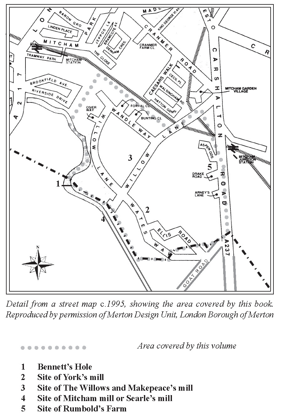
Detail from a street map c.1995, showing the area covered by this book.
Reproduced by permission of Merton Design Unit, London Borough of Merton
Area covered by this volume
1 Bennett’s Hole
2 Site of York’s mill
3 Site of The Willows and Makepeace’s mill
4 Site of Mitcham mill or Searle’s mill
5 Site of Rumbold’s Farm
WILLOW LANE AND BEDDINGTON CORNER
Willow Lane rail bridge (ENM March 1974)
Derelict watercress beds between Brookfields Avenue and Willow Lane
(ENM May 1966)
Chapter 1
PREHISTORY
We can imagine the Wandle for much of the early post-glacial period,
commencing around 7000 BC and lasting until about 5000 BC, as a
heavily braided river following a meandering course across the broad
valley now occupied by Mitcham. The gradual amelioration of the
climate since the end of the last glaciation had allowed a change from
tundra to scrub and open mixed woodland to take place, and an abundance
of fish, together with flocks of wild fowl attracted to the meres and wet
lands bordering the river, would have rendered the valley increasingly
attractive to wandering bands of Mesolithic hunter-gatherers. Examples
of their flintwork have been found on Wimbledon Common,1 and a
seasonally occupied camp site, dated tentatively to around 4000 BC,
was identified by the river’s headwaters at Carshalton and excavated in
the mid-1960s.2 From gravel pits being dug near Beddington Lane in
1912 came a distinctive tranchet flint axe-head3 and, nearby, a pottery
bowl of the transitional Mesolithic/Neolithic form, but so far nothing
of the period has been reported from Mitcham itself.
The subsoil of the Willow Lane area, as indeed much of the floor of
the valley extending south-east towards Croydon, is a mixture of sands
and gravels typical of the Wandle flood plain. There is no consistent
stratification, and the evidence pointsto sedimentshaving been laid by a
river which was often turbulent, constantly changing its course, cutting
new channels and redepositing transported materialas the flow increased
with the melting of winter snows, or following periods of prolonged
rain. That this regime had persisted until comparatively late during the
pre-historic period was demonstrated when the laying of a new gas main
across Cranmer Green in the 1970s provided an opportunity to examine
the underlying gravels. Here, among the contorted strata, were pockets
of roots and woody material a metre or more below the surface, samples
from which gave surprisingly recent carbon-14 dates of around 1200
BC, placing their deposition firmly within the Middle Bronze Age.4
It was during the later Bronze Age that two palstaves, a type of axe,
were left on Mitcham Common near the future site of Mitcham Junction
station.5 They may have been lost, or were perhaps part of the stock-
in-trade of a travelling smith, placed in a temporary hiding place from
whence he failed to retrieve them. A contemporary ditched enclosure,
WILLOW LANE AND BEDDINGTON CORNER
possibly a hill fort, was situated strategically on the uplands beyond
Carshalton Beeches,6 and archaeological surveys in the late 1980s in
advance of gravel extraction to the south of Mitcham Common have
produced evidence of field boundaries.7 The indications are, therefore,
that by the first millenium BC small farming settlements, part of a wider
community having a tribal centre south of Carshalton, were established
throughout the valley. This is likely to have remained the situation until
the Roman period, and the pattern of land use thus established persisted
into the Middle Ages.
Although of variable depth, the loams and brickearths overlying
the better-drained areas of the river terraces are easily worked, and
would certainly have been attractive to early cultivators. Clearance of
the natural cover of open woodland presented few obstacles, but the
fertility of those areas where the topsoils are thin would soon have been
exhausted. Once abandoned, this marginal land would quickly develop a
vegetational cover typical of acid heathland, fit only for rough grazing.
Where not subjected to the depredations of browsing livestock, such
terrain would have reverted rapidly to woodland with an underlayer of
shrubs. Inareas pronetofloodingtheseasonaldepositionofalluviumby
the river was followed by an annual regrowth of lush herbage, offering
rich grazing. It is from the more favoured locations on the deeper loams,
slightly elevated above the flood plain but sharing the abundant wild
life of the wetlands, that we have the first evidence of settlement.
Before gravel digging began on the Hundred Acres site to the south of
Mitcham Common in 1992, trial excavations by the Museum of London
Archaeology Service (MoLAS) produced evidence of Neolithic and
Bronze Age farming activity indicative of a nearby settlement.8 In 1993
MoLAS conducted another evaluation in advance of redevelopment
of the former Wandle Valley Hospital site upstream from Goat Bridge,
off Middleton Road.9 Here the evidence was of occupation spanning
the 1,500 years prior to the Roman period. At Beddington, on land
occupied by Thames Water’s sewage treatment works, an Iron Age
farmstead was excavated in the 1980s.10 At this site a group of typical
Celtic round huts was found to have been replaced by a Roman villa
complete with a small bath-house. The outbuildings included a large
aisled barn, and what was obviously the heart of a working farmstead
pREHISTORy
seems to have remained a viable unit at least the mid-fourth century.11
Settlement continued in the vicinity into the post-Roman period, and
in the 1870s an ‘Anglo-Saxon’cemetery of the fifth and sixth centuries
was discovered nearby, off Beddington Lane.12
From the accumulating evidence provided by archaeological work in
the Mitcham area over the last 70 years a similar picture is emerging
of a scatter of small farmsteads during the Roman period. Moreover,
it is a reasonable assumption that these persisted after the British re
established independence from Rome in the fifth century, for the large
‘Dark Age’ cemetery at Ravensbury, excavated early last century,13
contained a number of burials with late Roman material as well as
early Saxon grave goods. This implies a significant degree of cultural
and ethnic fusion between newcomers to the area and the indigenous
population. Continuity of settlement close by is further indicated by
fragments of Romano-British and Saxon pottery recovered from a
possible ditched enclosure and other features dug into the underlying
gravel at two sites excavated near Mitcham church.14 Residual Roman
potsherds and other domestic waste ascribed to the early to middle Saxon
period was also found by MoLAS working at a site off Tramway Path,
to the south of Mitcham station, in 1997.15
The aggregates underlying the area now covered by the Willow Lane
Industrial estate were largely removed during a period of intensive
commercial exploitation during the inter-war period. Regrettably,
the archaeology was largely destroyed in the process, but in 1928 the
discovery was reported of a group of five undamaged Romano-British
pottery vessels of the third or fourth century during the course of gravel
extraction by Hall & Company on the south-east side of Willow Lane.16
The precise location of the site is not clear, but it was described as being
2-300 yards west of the Wimbledon to Croydon railway line (now the
tram track). Two of the pots, one a beaker patterned with small notches
and the other a ribbed flask of buff gritty ware, were dated to AD 250
300. Both accompanied a burial, one being found at the left elbow and
the other at the feet of the skeleton, which lay in an iron-reinforced
wooden coffin. Athird vessel discovered nearby, but not associated with
the inhumation, was a plain dark bottle-necked vase of the second half of
the third century. A former ditch or trench on the same site yielded two
WILLOW LANE AND BEDDINGTON CORNER
more vessels with some animal bones and pieces of tile. One vessel, a
small roughly-made jar with a rounded edge, was of the so-called ‘New
Forest’ ware, and the other was a small light-coloured vase with belly,
neck and wide mouth. Both were ascribed to the third or fourth century.
As in the case of other Mitcham sites from the Roman period, the land
in the vicinity would appear to have been selected for its suitability for
arable farming, the gravel subsoil being overlain with rich loam and
Wandle alluvium. The evidence from Willow Lane points to the burial
of a moderately wealthy Romano-British farmer close by his homestead;
the pity is that the site was discovered before scientific excavation was
possible, and much of archaeological value was undoubtedly lost or
overlooked for want of expertise.
Romano-British pottery found off Willow Lane in 1928, reproduced from
SyAC XXXIX by courtesy of Surrey Archaeological Society
Good farming land is rarely abandoned for long, and it is a reasonable
assumption that in the hands of the farmer’s descendants, or else
newcomers to the area, the fields remained under cultivation and the
riverside meadows continued to provide pasture for cattle into the post-
Roman period. Under such circumstances the field pattern is also likely
to have persisted, and may well have determined the boundaries still to
be detected in the earliest maps to have come down to us.
Chapter 2
MEDIEVAL LANDOWNERS
Setting aside what can be deduced from the archaeological evidence,
little is known of early medieval or Saxon Mitcham. As Micham it first
received mention in a charter of AD 7271 confirming an earlier grant of
land in Surrey to the abbey at Chertsey and, by the reign of Edward the
Confessor, was evidently recognised as comprising two distinct ‘vills’
– Michelham and Witford. These subsequently merged to evolve as the
ecclesiastical parish and later local government district of Mitcham.2
For judicial as well as certain administrative purposes both lay within
the hundred of Wallington, an arrangement which survived, at least
in part, until well into the 20th century. When the Domesday Survey
was conducted in 1086 the value and extent of the two estates which
constituted Whitford were summarised by William I’s commissioners
as follows:
The Canons [of Bayeux] hold Whitford themselves from the
Bishop [i.e. Odo of Bayeux]. Edmer held it from King Edward.
Then and now it answered for 3 hides. Land for 2 ploughs. In
lordship 1 plough; 2 villagers, 6 cottagers with 2 ploughs. Meadow
4 acres. Value before 1066 and now 30s; when acquired 10s.
William son of Ansculf holds Whitford, and William the
Chamberlain from him. Lank held it from King Edward. Then it
answered for 2 hides, now for 1 hide. Land for [blank]. In lordship
1 plough. 2 villagers with 1 plough. 1 mill at 20s; meadow, 24
acres. Value before 1066, 50s; later 22s; now 60s.2
Records relatingtotheseholdings overtheensuingfivecenturies make
it clear that W(h)itford (or Wic(k)ford)3 included the Willow Lane area,
and that with the manor of Ravensbury it can be equated with much of
what today is known as Lower Mitcham. From the Domesday record it
can be seen that by the time of the Norman Conquest the vill of Whitford
not only comprised two distinct holdings, but that each obviously had
a separate identity. This distinction seems to have declined some time
during the late 17th century (by which time the two estates had become
fragmented), but the term ‘Wickford Green’was still being used in legal
documents as late as 1890, when a parcel of copyhold land abutting the
Cricket Green was enfranchised by the manor of Ravensbury.4
WILLOW LANE AND BEDDINGTON CORNER
The details recorded during the Domesday survey indicate that together
the two Whitford estates comprised some 600 acres, or roughly one
fifth the area of the later medieval parish of Mitcham. The population
numbered about 50, the heads of four households enjoying villein or
smallholder status, while a further six were landless peasants. The land
was evidently fertile, for much of it was under the plough, but there was
also a substantial acreage of meadow or permanent pasture, which one
might expect to find bordering the Wandle and liable to flood. The mill
on the FitzAnsculf estate can be identified with reasonable certainty
as the predecessor of ‘Micham, alias Wickford Mill’, which receives
mention in various documents as late as the 17th century, and stood a
little upstream from Mitcham bridge, on or near the site of the former
Grove Mill building.
Bishop Odo’s tenants, the canons of Bayeux, are believed to have been
deprived of their Whitford estate following the disgrace of their landlord
in 1088, and their lands were repossessed by the Crown. Fitz Ansculf’s
holding, on the other hand, remained in private hands and had by the
13th century become part of the extensive Surrey holdings of the de la
Mares, one of the great landowning families of the time.5
Members of the family were to demonstrate their reverence for the
Church on a number of occasions, one of the earliest being in about
1242, when the prior and convent of Merton received nine acres
of land with a building in Mitcham held of the fee of Sir Matthew
de la Mare.6 This particular property has not been located, but it is
significant thatparts of today’s Willow Lane industrial estate, lying to
the north of Willow Lane, were known in medieval records variously as
‘Mareshlonde’, ‘Mareysland’, the ‘Marrish’, or ‘Marrish Fee’. Whereas
there is every reason to accept that the land had taken its name from
the de la Mare or de Mara family, the term ‘marrish’ could possibly
have been descriptive, indicating marsh or marginal land. Such land,
partially drained and reclaimed or ‘inned’ from waste, was of little
value and was commonly rented out by the larger landowners rather
than held in demesne.
Transfer of tenure of another holding would appear to have taken place
in 1361/2, when William Mareys [sic] granted a substantial estate,
comprising what was described as ‘his capital messuage’ with associated
MEDIEvAL LANDOWNERS
buildings, gardens, crofts, meadows, pastures, woods, trees, hedges,
hays and ditches as enclosed, together with two water mills and a piece
of marshland ‘adjoining as enclosed by the water towards Beneytesfeld,
and all appurtenances in Wykford’ at 100 shillings per annum payable
during his lifetime, to ‘Sir’ Richard Porter, perpetual vicar of Mitcham,
and ‘Sir’ John de Scaldewell, perpetual vicar of ‘Westmorden’.7
William’s family, members of which were styled variously as de la
Mare or de Mara, had been in possession of a large estate in Mitcham
and Morden since the beginning of the 13th century. The site of
his ‘capital messuage’
has not so far been identified, and the exact
position of the second mill is a little uncertain, but there is no doubt
that ‘Beneytesfeld’ lay on the west or left bank of the Wandle. It
probably included much of what is now Poulter Park, and the name
persists today in Bennett’s Hole, or hollow, still marked on large
scale ordnance survey maps at the point where the river takes a sharp
bend to the east in the vicinity of the Watermeads. As the ‘Marsh
Fee Lands’ the land on the right bank of the river is also shown on
a map of the Cranmer family’s estate in Lower Mitcham drawn by
James Cranmer in 1717.8
The precise nature and significance of the conveyance confirmed in
1362 has to be a matter for conjecture, but in spirit it may have been
inspired by the example of Edward the Black Prince who in that same
year granted lordship of his manor of Vauxhall (which exercised
jurisdiction over much of central Mitcham), to the prior and convent
of Christ Church at Canterbury.9 The mid-14th century was a period
of acute economic and social stress, when in parts of the country the
labour force declined dramatically due to the Black Death, and good
farmland was being left uncultivated or turned over to sheep pasture
for the production of wool, which not only fetched a good price, but
was less labour-intensive. How Whitford fared is not known, but H E
Malden suggested, quite plausibly, that Mareys’s grant of land, involving
an annual payment during his lifetime, may have been to secure for
himself a form of pension or annuity.10
In 1380 the prior of Merton is said to have been holding the ‘manor’ of
‘Wickford’,11 but there is no evidence that a manor of this name existed
WILLOW LANE AND BEDDINGTON CORNER
in the strict manorial sense, and as used in this instance the term was
probably intended to describe an autonomous estate exercising certain
rights and liberties, and not beholden to any superior lordship. As part
of the more extensive manor of Ravensbury, which embraced properties
on both sides of the Wandle, the land known as Mareysland (now largely
covered by the buildings of the industrial estate) remained amongst the
assets of Merton priory until the dissolution of the monasteries, when
it was recorded as providing an annual income of £3 1s 8d.12
The approach to Willow Lane from Mitcham Common
(ENM September 1991)
Chapter 3
THE WILLOW LANE ESTATES DURING THE
TUDOR PERIOD
Lordship of the manor of Ravensbury, which in the later Middle Ages
(certainly until the mid-14th century) seems to have exercised jurisdiction
over much of the Willow Lane area, was purchased for £800 in 1531
from Charles Brandon, Duke of Suffolk, by Sir Nicholas Carew of
Beddington.1 An inquisition post mortem shows him also to have
been holding two acres of meadow in ‘South Mede’ as a tenant of the
Mitcham manor of Biggin and Tamworth before the Dissolution.2 Carew
subsequently fell from royal favour, and was executed on the orders of
Henry VIII in 1539. Tenure of Ravensbury thereupon reverted to the
Crown, and was granted, with Carew’s other estates, to Thomas Lord
Darcy of Chiche. In January 1554, following the accession of Mary I,
Sir Francis Carew, Sir Nicholas’s son, was ‘restored in the blood’, and
the Carew estates, including lordship of Ravensbury, were returned to
the family. Through various vicissitudes the manor was to remain in the
hands of the Carews for some 350 years, the few remaining manorial
rights being acquired eventually by the Princes Golf Club in 1907.3
The earliest known reference to land in the Willow Lane area dates from
October 1528, and mentions the lease (or more likely a sub-lease) for
20 years of a ‘Close of land in Mitcham, abutting North on Rowcrofte
and South on Mycham River’ granted by William Standon of ‘Mycham’
to a Thomas Lambkin. From the abuttals quoted the enclosure was
obviously part of Maresland, and the transaction evidently took place
before the Dissolution, while Merton priory was the owner, and with
Standon presumably holding the head lease.4 In his will dated January
1529/30 Standon, styled ‘a yeoman of the Crown’, directed that he
be buried in the chancel at Mitcham, and left various bequests to the
Church. To his grandson William he also bequeathed all his lease from
Merton priory in Mitcham called ‘Mareysfeeland’ together with his
‘capital messuage’, known as ‘Mareys Garden’.5
During the winter of 1544/5, following the dissolution of the monasteries
and the seizure of the estates held by the priory, ‘Mareslonde’ (which
included riverside land in both Mitcham and Carshalton) was granted
by Henry VIII to Robert Wilford (or ‘Wyleforde’), a member of the
WILLOW LANE AND BEDDINGTON CORNER
Merchant Taylors’ Company.6 The Wilford family had, in fact, been
connected with Upper Mitcham since the late 15th century, for Robert’s
father, James, who was master of the Merchant Taylors’ Company in
1494, is credited with having paid for the construction of the road from
Mitcham to Streatham.7 Robert was his eldest son and, on James’s death
in 1525, he inherited all his father’s ‘great messuage, land and tenements
with appurtenances’ in Mitcham.8 In May 1544 he was granted the
lordship of the manor of Biggin and Tamworth and with it land in
Mitcham formerly held by Merton priory.9 The latter, it seems likely,
was all, or part of, the estate held by William Mareys in the 14th century.
After the death of Robert Wilford’s widow, Joan, their lands in Mitcham
were sold by their daughter, Ann, and her husband, Henry Whitney,
‘servant of Sir Thomas Bromley, Lord Chancellor’,10 and by 1575 much
of the land in Lower Mitcham bordering the Wandle had passed into
the hands of Thomas Smythe, a high-ranking civil servant in Elizabeth
I’s government, holding the position of ‘clarke of ye Greencloth’.11 On
his death Smythe willed the bulk of his large estate (a significant part of
which lay in Wandsworth) to his second wife, Elener.12 She remarried in
1576, her husband being Bartholomew Clerk(e) of Clapham, who was a
doctor of civil law and Dean of the Arches.13 In 1584, 30 acres of land in
Mitcham in the tenure of Dr Clerk were the subject of a dispute between
Sir Francis Carew and Charles Howard, no less a person than Baron
Howard of Effingham, Earl of Nottingham and Lord High Admiral at
the time of the Armada. Sir Francis, the defendant, maintained that,
together with a house and two watermills, the land fell within his manor
of Ravensbury, whereas Lord Howard asserted that it lay within the
jurisdiction of the manor of Reigate.14 The outcome of the dispute is
not known, but an agreement seems to have been reached, for a quit
rent was being claimed of the owners of one of the mills near Mitcham
bridge by the steward of Reigate as late as 1940.
At the time of his death in 1575 much of Thomas Smythe’s property
was in ‘debte, daunger and bonde of twoe thousand poundes’, and the
prospects for George, his eldest son and heir, then a boy of 14, seemed
bleak. His mother’s choice of Bartholomew Clerk as her second husband
proved fortunate for young George, for his stepfather redeemed much
of the family’s estate, including his late father’s ‘choice house and
THE WILLOW LANE ESTATES DURING THE TUDOR pERIOD
Landes’, to which he had no title in law, and eventually made them
over to the boy. The family house occupied a site at the waterside just
below Mitcham bridge, and it was here that George, who married Rosa
Worsop of Clapham, was living by 1590.15 He evidently continued the
work of his stepfather in reclaiming Thomas Smythe’s estate, and a
deed of bargain and sale dated February 1594/5 records his purchase
from ‘Henry Whitney of Micham esq. and Anne his wife’ of four acres
by a third mill, described as a portion of ‘Mareslande or Maresfee’ and
once ‘part of the dissolved monastery of Merton’.16 This mill, with a
house and adjacent four acres, can be identified as a distinct holding on
the Carshalton side (left bank) of the Wandle, which became Searle’s
mill in the 18th century.
References to other parcels of land identifiable as being in the Willow
Lane area occur for the first time in documentsof the mid-16th century,
when written sources become more plentiful. Until the early years of
the Victorian era, when it was still mainly farmland, that part of the
area lying to the south of Willow Lane, that is, between Willow Lane
itself and Goat Green, was still occasionally referred to as the ‘South
Field’. Most of the East and West common fields of Upper Mitcham
were then still under cultivation, mainly as ‘physic’ or herb gardens.
There the old strip holdings and furlongs persisted, although by the mid19th
century individual plots had been fenced and some amalgamated.
The two fields had obviously formed part of a medieval open field
system, an ancient pattern of land use in which the South Field seems
to have been included. A note in James Cranmer’s estate book shows
that in the 18th century it was certainly recognised as a common land,
although some enclosure had already taken place by the middle of the
16th century. The frequent reference to the land at this time as South
Field ‘meade’ implies that it was maintained as hay meadow and, no
doubt, for the grazing of livestock.
An early documentary reference to ‘Southfyld meade’ can be found
in a minute of the Kent and Surrey Sewer Commissioners dated 1569,
recording the decision that a Thomas Pynner should be required to carry
out maintenance work to the riverbank adjoining his property.17 Pynner,
who was chief Clerk Comptroller to Elizabeth I, was in occupation of
a house in Lower Mitcham, purchased in 1570 from a John Carpenter
WILLOW LANE AND BEDDINGTON CORNER
as ‘a messuage or tenement’ in Mitcham ‘late the inheritance or part
of the possession of John Wilford’ for £80.18 (The extensive grounds
which during Pynner’s time surrounded his impressive mansion to the
south of the Cricket Green, were eventually divided to provide, inter
alia, plots for two substantial houses sometime during the mid-17th
century. What remained survived largely as undeveloped parkland
until used for the erection of the houses forming the Mitcham Park
estate shortly before 1900).19 In 1576 47½ acres of copyhold land in
the manor of Ravensbury (shown in Cranmer’s map of 1717 to be lying
on the south-eastern side of Willow Lane) were surrendered to him.20
‘Southfyld Meade’ remained part of the estate in Lower Mitcham
owned by Thomas Pynner until late in the 16th century. He was buried
at Mitcham, where a tablet to his memory can still be seen, high in the
chancel, proclaiming him to have been
at the tyme of his deathe justice of peace in this County of
Surry; a man of good place & worthe in his lyfe tyme, and much
lammented for his losse at the tyme of his deathe; who dyed the
6th daye of Julye … 1583
In February 1587 two enclosures of meadow and pasture in South Field
known as Long Close and Firsey Close, were included in the indenture
of sale of the Pynner estate in Mitcham by Arthur Langworth to John
Dent of London.21 The two closes can be seen on Cranmer’s map lying
immediately to the north of what today is Goat Road, and extending
from Carshalton Road as far as the Wandle. A note in Cranmer’s hand
states that the land was ‘enfranchised’, i.e. released by agreement from
the copyholder’s obligation to meet manorial dues, in November 1580,
which would have been whilst the land was in Pynner’s possession.22
Later records make it clear that tenure was customary freehold, and
therefore carried an obligation on the part of the owner to observe the
customs of the manor. This was to be of particular importance next
century when, as we shall see, action was taken to ensure commoners’
rights of access were respected.
In November 1588 Dent, a City merchant and member of the Salters’
Company, entered into an indenture of ‘sale’ (probably the granting of
a long lease) of Long Close and Firsey Close to a Thomas and William
THE WILLOW LANE ESTATES DURING THE TUDOR pERIOD
Cater.23 Dent retained title, and early in the 17th century the freehold
passed into the possession of Sir Henry Savile of Yorkshire, who married
Dent’s 20-year old daughter Mary in 1607.24
Parts of Whitford, known as the ‘Horse Meads’, were evidently prone to
flooding and seem to have been kept as rough pasture or watermeadow
until the mid-18th century, after which they were used as crafting or
whitstering grounds for the bleaching of calicoes and other textiles.
With the improvement in land drainage which accompanied the gradual
urbanization of Lower Mitcham, the level of ground water in the
Wandle gravels dropped appreciably over the 19th and 20th centuries,
but the lower-lying areas, especially in the vicinity of the boundary
between the parishes of Mitcham and Carshalton, remained permanent
waste or ‘common’. Here, no doubt, lay the inspiration for the name
‘Cran(e)marsh’, by which land abutting Mill Green to the south of the
emerging industrial estate was known in the late 18th century. Apart
from a few houses built around its margins the Green itself remained
part of Mitcham Common, and largely avoided enclosure until it was
protected by legislation at the close of the Victorian era.
As the natural bleaching of textiles declined during the 19th century,
due to the increasing use of synthetic chemicals, much of the land
nearest to the river, extending from Mill Green to Mitcham bridge, was
adapted as watercress beds. This use persisted until the late 1940s, the
last commercial grower being E James & Sons of Brookfields Farm,
whose ‘Vitacress’, now grown further afield, is still well-known on
the wholesale market. Much of the ground surface of the Willow Lane
estate has since been raised by tipping following gravel extraction, and
is now covered by industrial premises. To facilitate future extension
of the Wandle Trail, two acres of riverside land, formerly occupied
as watercress beds, were purchased from Coloquid Paints Ltd by the
London Borough of Merton in 1971. To them was added a fraction of
the original Maresland, set aside in 1993 after consultation with English
Heritage, to create the Bennett’s Hole local nature reserve.
Part of the South Field, surviving as three rectangular copyhold closes on
the southern side of Willow Lane, is shown on the map of lands within
the manor of Ravensbury prepared in 1825.25 The contemporary court
WILLOW LANE AND BEDDINGTON CORNER
rolls disclose that one of these fields bore the quaint name
of ‘Mount
Nod’, often given in jest to land which was extremely flat. However,
it is also a tag occasionally applied to an old burial ground and, since
it was near here that the Roman pottery and interments were found in
the 1920s, we may have an echo of a folk memory recalling its former
use as a cemetery, and a link with the Romano-British farmstead which
seems to have existed nearby.
Watercress beds off Willow Lane, c.1900,
reproduced by courtesy of Merton Library & Heritage Service
Chapter 4
A CENTURY OF CHANGE (1607-1688)
New Landowners
The earliest map to have survived showing the Willow Lane area is
preserved in the collection of Howard estate papers at Arundel. Dated
provisionally to 1620, it marks ‘South-Lands’ bordering the Wandle
below Mill Green, which is described as ‘Cranemarsh common nth in
ye maner of wallington’. ‘Benuts hole’ is marked, and a small house is
depicted in the south-western corner of the ‘South-lands’. ‘Sr Hy Savil’
is written along the boundary with Mitcham Common, which dates the
map after 1607. The ends of what may be boundary fences within the
South Field are indicated, but no attempt was made to show them in
their entirety.
Sir Henry Savile, who received his knighthood at the coronation of
James I and was created a baronet in 1611,1 was the son of Sir John
Savile, Baron of the Exchequer, and Jane his first wife, the only
daughter of Richard Garth of Morden.2 Sir Henry married John Dent’s
20-year-old daughter Mary in 1607 and, through this alliance, came
into possession of part, if not all, of the former Dent estate in Lower
Mitcham. Styled ‘of Methley in Yorkshire’ he was admitted in May
1619 to the customary tenancy of Ravensbury as the owner of four
copyhold closes of land in the South Fields, but it is not known if he
acquired them as part of his wife’s inheritance or by purchase.3 A little
over three years later he and Lady Savile took the decision to dispose
of all their freehold and copyhold lands in Willow Lane and also her
late father’s Mitcham house, until recently the residence of Sir Julius
Caesar, Master of the Rolls. In April 1623 the steward of Ravensbury’s
deputy, Sir John Jackson, received the formal surrender by Sir Henry
and his wife of the customary and copyhold tenure of ‘all those four
closes of pasture and arable containing by estimation twenty acres and
one woode lying in a great Close called the Southfield’. The surrender
was ‘to the use of Richard Broughton of London, gentleman’ for ‘a
valuable consideration’. (Elsewhere the sum of £900 is mentioned).4
Among the abuttals cited for the Southfield in the surrender document
were Mitcham Heath, the river and on the north, the ‘Marris fee Landes’.
A ‘Licence of Alienation’ granted by the King, agreeing to the sale by
Sir Henry to Richard Broughton of the two closes called the Long Close
WILLOW LANE AND BEDDINGTON CORNER
and Firsey Close in Southfield is dated March 1624.5 The sale of the
Saviles’ ‘mansion house’ and associated land in Lower Mitcham took
place the following November.6
Broughton acquired various other houses and parcels of land in Lower
Mitcham at this time, but it is not known if he took up residence in
the village. In 1631 he surrendered the lands held of the manor of
Ravensbury in favour of another Richard Broughton and his wife, and
thereafter descent of title to the different parts of the estate is somewhat
complex. The rights of inheritance were disputed,7 but eventually Peter
Broughton, the younger son and heir of Thomas Broughton, obtained
title and was in possession of the bulk of the estate in 1654, when it
was purchased by Robert Cranmer. It appears to have been during the
Broughtons’ ownership of the old Pynner mansion in Lower Mitcham
that the grounds were divided, providing sites for two new houses, and
it was whilst the Southfield was in the family’s hands that an attempt
at permanent enclosure was thwarted.
When Richard Broughton completed purchase of the Savile property in
1624, Firsey Close and Long Close were in the occupation of Deborah
Collant, as a lessee of Sir Henry.8 As we shall see later in this chapter,
the Collant family were whitsters, or bleachers, and were using the
land abutting Mill Green as ‘whiting grounds’. How long the Collants
remained in occupation after sale to Broughton is not clear, but within
a few years the action taken by a group of parishioners to uphold the
right of commoners to have access to the common fields, and against
the recent erection of gates, must have severely restricted the use of the
two closes for bleaching purposes.
Reaction to the enclosure of common fields, a practice which carried
serious economic implications for those still exercising common rights,
eventually came to a head in Mitcham during the reign of Charles I. The
dismissal of Parliament in 1629 was followed by the so-called ‘Eleven
Years of Tyranny’, although probably the great mass of the people were
satisfied with this period of autocracy. Certainly, attempts were made at
administrative and social reform, and concern was expressed and shown
for the poor, unemployed and orphaned. The Court of Star Chamber
acquired popularity through its vigorous action against enclosures of
arable land, those guilty being held partially responsible for the high
A CENTURy Of CHANGE (1607-1688)
price of corn, and heavily fined. ‘Last year’s famine’, Bishop Laud told
an Essex farmer in 1631, ‘was made by man and not by God, solicited
by the hardheartedness of men’. Taking encouragement from the
attitude adopted by the King’s ministers towards attempts to deprive the
commoners of their ancient rights, the villagers of Mitcham re-asserted
their time-honoured control over the common fields. It is not clear
if the action was in response to a general threat to the still-unfenced
fields, or whether it was prompted by a specific instance. Whatever the
reason, a complaint by a group of cottagers to the King’s Privy Council
against recent enclosures resulted in the lords of the Privy Council
requiring the inhabitants at large to look into the matter and to make
recommendations.
The report, signed by 27 of the principal inhabitants on behalf of the
rest of the community, was dated 14 December 1637, and is inscribed
in the parish register.9 The signatories were agreed that in future the
common fields should be laid open for grazing as soon as the corn
harvest had been gathered, and that they should thereafter remain open
until St Luke’s day, 18 October. The right to pasture extended only to
those inhabitants ‘that hath been accustomed to have benefit of the
Common of the said fields’and the villagers agreed that any livestock
found in the fields after St Luke’s day should be impounded and their
owners fined. Should animals be
found in the
common fields after
Lady Day, 25 March, the fine would be doubled. Collection of fines
and general supervision of the common fields was to be in the hands
of a common keeper. Finally, and most importantly for people like
Richard Broughton and the Collants, the villagers agreed that all those
who had enclosed any part of the common fields should be required to
take away their gates so the enclosures might once again be ‘common
to the fields’. Unlike the East and West Fields, which were in multiple
tenure and fencing of individual holdings could not have taken place
without general acquiescence, the South Field was in the hands of one
landowner who was also a newcomer to the village. The risk of its
permanent loss to the commoners could thus have been a very real one.
As we have seen, parts of the field were already in use as bleaching
grounds, which was not compatible with livestock being given free
access. None of the common fields in Mitcham is named specifically in
the complaint to the Privy Council, and it is not clear that the South Field
WILLOW LANE AND BEDDINGTON CORNER
was implicated. Nevertheless, the decision was sufficiently important for
James Cranmer, who inherited the whole of the South Field following
the death of his father, to transcribe the entry in the parish register into
his memorandum and account book.10
In May 1652 James’s grandfather, Robert Cranmer, an East India
merchant recently returned to the City after a period abroad in the
Company’s service, bought from Ralph Trattle various freehold closes
of land ‘in Marrish Fee’, described as three, four and eight acres leading
into Mitcham Common, seven acres, and the Horse Meads near the river
side.11 These had been sold to Trattle three years before by members of
the Smith family to whom had passed property in Mitcham formerly
owned by George Smith (or Smythe) of Mitcham Grove.12 Two years
later, in February 1654, Cranmer also purchased Firsey Close and part
of Long Close, totalling 26¼ acres, together with a house and whiting
ground, from a Thomas Hopkins.13
These were but two in a whole series of property transactions in which
Cranmer was engaged during the Commonwealth and the Protectorate
of Cromwell. At their conclusion, Cranmer was lord of the manor of
Mitcham, in possession of the rectory and the advowson of the parish
church, and owner of an estate which established him as one of the
major landowners in the parish. The position of pre-eminence in local
society which he attained thereby was inherited by his descendants, and
lasted for nearly 350 years. Trattle, who had recently built a large house
for himself in Mitcham, was styled as ‘of London’ and described as a
‘fishmonger'(probably more accurately a member of the Fishmongers’
Company)14, but of Hopkins, also ‘of London’, we know little. Both
were involved in the disposal of part of the estates of Sir Henry Burton of
Mascalls House, Carshalton, who was financially ruined by his support
of the Royalist cause during the Civil War, and of Sir Nicholas Carew,
whose possessions were heavily mortgaged at this time.15
The second map showing the Willow Lane area to have survived, at
least in the form of a copy, is the ‘projection’ prepared byWilliam Marr
in 1685. Mainly concerned in portraying Mitcham Common, Marr was
probably not over-particular with the details of the peripheral estates,
and for that reason may not be completely reliable. The Willow Lane
area is shown divided into three with the note that ‘These Inclosures
A CENTURy Of CHANGE (1607-1688)
(are) in the Parish of Mitcham’. He shows a ‘Coloring Mill’ on the
banks of the Wandle, and uses ‘Mitcham Heath’ as an alternative name
for Cranmarsh.16
Robert Cranmer’s great-grandson James died in 1801, and the family’s
Mitcham property passed initially to his daughter and grandchildren,
and eventually
through marriage to the Simpson family. It was finally
broken up in a series of sales after the 1914/18 War. Through the medium
of a large collection of deeds, account and estate books which have
survived in the care of Surrey History Centre, and also from the later
Simpson correspondence held by Merton Heritage and Local Studies
Centre, much of the history of the Willow Lane estate since the mid
17th century can be reconstructed with little difficulty.
As we have speculated earlier, parts of the Willow Lane area could
conceivably have been brought into cultivation during the Roman
period. Given the well-known phenomenon of continuity of occupation
once land has been cleared and broken with the plough, it is perhaps
pertinent to note that until it was demolished late in the Victorian period,
a ‘very old farmhouse’ stood on the edge of the South Field, facing
Carshalton Road. Known as Henman’s Farm, the house was already
old when it was sold to Robert Cranmer in 1652, and substantial repairs
and improvements were carried out some 30 years later by his son John.
One can only wonder if Henman’s farmhouse might have been the last
in a long succession of buildings which had stood on or near the same
plot of land. The site once occupied by the farmstead is now covered by
industrial yards and buildings, but the opportunity may yet occur for a
detailed archaeological evaluation before the inevitable redevelopment
takes place at some time in the future.
Industrialisation Begins: The Arrival of the Dutch Bleachers
We are told by Pliny that the Gauls and Belgae bleached their fabrics
in a primitive way, and no doubt the practice of bleaching homespun
linen continued to be widespread throughout Europe well into the
Middle Ages. By the 16th century it was tending to become localised,
at least where conducted on an industrial scale, and an area around
Haarlem Lake in Holland acquired a monopoly in the bleaching of the
best grey cloth.
WILLOW LANE AND BEDDINGTON CORNER
The process at this time could be a lengthy one, lasting up to six months,
involving the ‘bowking’ or steeping of the cloth in a potash lye of
wood ashes in a bowking or buckinghouse, souring in buttermilk or
fluid prepared by fermenting bran or rye flour, and finally subjecting
the fabric to prolonged exposure to sunlight in a procedure known as
‘crofting’. It was necessary not only to rinse the material thoroughly
between each stage, but also to keep it wet during the crofting process,
for which a supply of clean water was vital. The low-lying meadows on
the banks of the Wandle were ideal as bleaching or ‘whitening’ grounds,
and it was commonly the practice for them to be interspersed with long
parallel ditches to reduce the labour involved in transporting the water.
The textiles being bleached were spread out on the intervening strips of
mown grass, enabling operatives to walk alongside, skilfully drenching
the cloth with the aid of long scoops. Given favourable weather and
long hours of daylight the sun would bleach the fabric in a period which
could be anything from a few days to a month.1
The earliest indications of Dutch involvement in the bleaching trade
in Britain are references to whitsters from the Netherlands working
in Southwark and Bermondsey in 1583. In Mitcham, the evidence for
newcomers from the Low Countries, if not actually of Dutch bleachers,
comes firstly from the Lay Subsidy Accounts of 1593-4, which list six
‘strangers’ residing in the parish, Henrick Thunderman, Haunce Keyzer,
Adryan Collande, Garratt Collande, Magdalen Van Daly and Joyssamyne
Nenyansses.2 Spelling at this time, even of straightforward English names,
tended to be somewhat erratic, and ‘Adryan Collande’ in the subsidy lists is
probably the same ‘Adrian Collins’ of Mitcham, described as a ‘whitster’,
who was overseer of the will of the vicar of Mitcham, the Revd William
Ansell, who died in 1600.3 Collande (or Collant), who is understood to
have come from Lambeth,4 lived for well over a quarter of a century in
Mitcham, the clerk recording his burial on 13 January 1620/21 noting that
he was ‘a Dutchman dwelling a long tyme in this Parish of Mitcham’.5
Collande is usually credited with having introduced the bleaching industry
to this part of the Wandle valley, but the process must have been familiar
long before his time, albeit perhaps only practised on a domestic scale.
The Collande family seems to have been a large one, for in addition
to Adryan and Garratt in Mitcham, we have Steeven (sic) and Andrew
A CENTURy Of CHANGE (1607-1688)
‘Callante’ who witnessed a will in 1602.6 At this time Andrew was in
occupation of land which formed part of the ‘Southfyld meade’. It was
presumably already in use as a bleaching ground, and in 1610 he was
required by the sewer commissioners to cleanse 100 rods of the river
abutting his property before ‘alhalowtide’ that year.7 A daughter born to
Adrian’s wife was baptised in 1616, and a Susanna ‘Callant’ (sic) was
married at Mitcham the following year.8 In 1624 bleaching grounds were
held by Deborah Collant, who may well have been Adrian’s widow, as
a tenant of Sir Henry Savile.9 The land was described as comprising
two ‘whiting places’, Firsey Close and the adjoining Long Close. We
have seen in the previous section that these enclosures lay to the north
of Mill Green and extended from the Wandle eastwards to the edge of
Mitcham Common.
The history of the Willow Lane bleaching grounds and of the Collande
family now becomes more obscure. No one of that name (or its variants)
is listed in the Mitcham hearth tax returns for 166410 and, unless exempt
by reasons of poverty, the family would appear either to have left the
village or to have failed to provide male heirs to survive to adulthood.
One is tempted to see a connection between their disappearance from
Mitcham and what might have been a temporary cessation of the use
of the South Field as bleaching grounds, following the protests against
enclosure of the common fields. As we have seen, feelings reached a
climax in 1637, when an appeal to the Privy Council apparently received
a sympathetic hearing.11 The instruction that all gates be taken away
and the land made available for common grazing for a substantial part
of the year would obviously have rendered the crofting of textiles on a
commercial scale difficult, if not impossible.
By 1717 Long Close had been divided into two parts, a six-acre
enclosure immediately adjoining the site of the future Goat inn, and
an eight-acre enclosure known as the Barn Field or the House Close.
Henman’s Farm, a substantial house with outbuildings which is likely
to have dated from the early 17th century, if not earlier,12 occupied the
House Close, and was purchased by Robert Cranmer in 1652.13 There
had been another house associated with the Firsey Close whiting ground
when the latter was acquired by Cranmer in 1654, and we have noted that
a building is shown at the southern end of Firsey Close, close by Mill
WILLOW LANE AND BEDDINGTON CORNER
Green, in the map produced about 1620.14 Either or both these houses
could well have been occupied by members of the Collant family in
the early years of the preceding century.
During the late 17th, and for much of the 18th century, the trade of
bleaching calicoes and linens flourished in Mitcham and throughout
the Wandle Valley. Factors initially favourable to the establishment and
growth of the industry were, firstly, the relatively easy access to the port
of London, whence came the bulk of the imported cloth. Secondly, the
Wandle provided an abundant supply of water which was held to possess
a special quality making it ideally suited to the processing of textiles.
Much of the material passing through the hands of the bleachers was
destined for the dyers and printers, and because of the amount of capital
tied up whilst cloth was being processed, it became the practice for the
larger merchants to ‘put out’ work to the various specialists, and to buy
backthefinished material.15 Proximity to sources of working capital was
therefore vital to success. London was already the financial centre of
the kingdom and, moreover, the principal market for the final product.
Mitcham and its neighbouring villages were thus ideally situated to take
advantage of the period of prosperity enjoyed by the textile industry in
the Home Counties during the latter half of the 18th century.
Whereas dyers predominated in the lower reaches of the Wandle, it
is noticeable that in Mitcham the industry seems to have attracted
a different group of specialists or semi-specialists, described in the
parish records variously as ‘whitsters’, ‘thread whitsters’, or ‘cloth
whitsters’. The distinction may be more apparent than real, but from
the numerous examples listed in the victoria County History of Surrey
one might cite Thomas Hore of Mitcham, a mid-17th-century whitster,
mentioned in the will (dated 1653) of his brother-in-law Henry White,
a weaver; John and Charles Camell, both ‘thread whitsters’ and, it is
believed, of Dutch origin, and William Parish, a ‘cloth whitster’, who
was buried at Mitcham in 1772. Wills, like that dated 1659 of James
Parry of Mitcham, a whitster and citizen and Leatherseller of London,
who was styled ‘gentleman’ in the burial register, or that of Roger
Besswell, who died around 1728 in possession of land and houses in
Mitcham, show they were often moderately prosperous, and by no
means lowly members of the community. Contrary to this trend towards
A CENTURy Of CHANGE (1607-1688)
specialisation, however, quite early in the 18th century there were
Mitcham whitsters like William Taylor16 who also carried on the trade
of calico printing. Although probably only operating on a small scale,
he provides, nevertheless, an early example of the close association
between bleaching and the subsequent process of printing, often carried
on by one firm, which became such an important feature of the industry
towards the end of the century.
Detail from map of the Cranmer estate drawn by James Cranmer in 1717
reproduced by permission of Surrey History Centre – SHC 470/1 p5
WILLOW LANE AND BEDDINGTON CORNER
york’s millhouse and the old course of the Wandle (ENM April 1966)
Chapter 5
THE LOGWOOD MILLS
Like bleaching, the decoration of textiles by the process of dyeing
is also of very ancient origin, and the skills of the craft must already
have been known in Britain by the Neolithic period. Such was the
importance and prestige of the trade in the Middle Ages that the
Company of Dyers was granted incorporation by the City of London
in 1472. Until the invention of synthetic aniline dyes in 1856, the
dyestuffs used were derived from natural sources such as weld, or
dyer’s rocket (Reseda luteola), which produces yellow, madder root
(Rubia tinctorum) for reds, and woad (Isatis tinctoria) and indigo
(from various Indigofera species) for blues. The value of ‘brazil
wood’ as another source of red dye was known in England at least as
early as the 14th century, and it is mentioned by Chaucer. Reserves
of this wood, from which a range of beautiful colours from scarlet to
peach could be produced, were found to be so plentiful in the newly-
discovered region of South America that King Emanuel of Portugal
is said to have taken the name ‘Brazil’, from the Portugese ‘brasa’,
meaning a live coal or glowing fire, for his new colony. There are
also references in the early accounts to ‘blockwood’, from which a
black dye was extracted, ‘logwood’, which produced a French navy
blue and, by the end of the 18th century, to ‘quercitron’ from the
water-oak (Quercus nigra) of the south-eastern USA, which began
to rival weld as a source of yellow.
In Surrey, Guildford and Godalming became centres of the dyeing
industry in the 16th and 17th centuries, to be followed by Southwark
and the Wandle valley in the 17th and 18th. As we have observed
earlier, immigrants from the Netherlands settled in large numbers
in the vicinity of London in the 16th century, in particular in northeastern
Surrey. Amongst other crafts, they introduced new skills
in the decoration and embellishment of textiles. Unfortunately the
colours then available were not fast and, holding that the use of such
‘fugitive’ dyes was deceitful, the Elizabethan parliament endeavoured
to abolish them. The effort proved in vain, however, probably due to
the pressure of demand and the fact that satisfactory alternatives were
still unknown. Despite numerous prosecutions for the use of prohibited
colours, their production increased.1
WILLOW LANE AND BEDDINGTON CORNER
The extraction of dyestuffs from raw materials like dyewoods and
madder root was preceded by cutting and milling for which water
was the only satisfactory source of power available. A brazil mill was
working at Wandsworth as early as 1571, and there were others, often
referred to as ‘drug’ mills, at Wimbledon, Merton and Carshalton. At
Wandsworth the dyers tended to specialise in plain-coloured work,
using wool, fur and leather, and earned a reputation as ‘scarlet dyers’.
On the upper reaches of the Wandle another market of importance to
the drug millers was to be the trade of calico and silk printing, which
developed in the 18th century.
On the map produced by Marr in 1685,2 a ‘Coloring Mill’ is shown
near the eastern bank of the Wandle a few hundred yards downstream
from Mill Green. Nothing is known of the early years of this mill,
or of its tenure, and it is not mentioned in the deed of sale dated 27
February 1654, in which Thomas Hopkins confirmed his sale of the
adjacent Firsey Close and Long Close to Robert Cranmer. Marr’s map
is obviously diagrammatic, and therefore cannot be taken too literally,
but it is adequate, nevertheless, to demonstrate the existence of the
colouring mill and its approximate location. It is also interesting to note
his comment, written alongside the Wandle below Cranmarsh, that here
‘The River divides Mitcham Parish and Carshalton Parish’.
A later map, drawn by Robert Cranmer’s grandson, 19-year-old James
Cranmer, in April 1703 and evidently based on Marr’s map, also
shows the mill, but as a somewhat larger structure astride a substantial
watercourse or mill-head.3 The building is larger than that in the earlier
map, and Cranmer’s sketch indicates that the main flow of the river
below Cranmarsh had been diverted into a new channel, following a
course roughly parallel to, but to the east of, that shown by Marr 18 years
before. The erection of the new building can be attributed to Richard
Bond, a wood grinder, to whom James Cranmer’s father, John, granted a
lease of the land at the very beginning of the 18th century. The diversion
of the river was also carried out by Bond, who was later to claim that
he had laid out ‘upwards of £2,000’ in works which included building
a new house and either modernising or completely rebuilding the mill.
The amount invested was impressive, and no doubt commensurate
with expectations of profit. Whether Bond bore the whole of the cost,
THE LOGWOOD MILLS
or had received some financial assistance from John Cranmer is not
clear. In 1712 Anne Cranmer, John’s widow, granted Bond a 21-year
lease of the colouring mills and 26½ acres of adjacent whiting ground.
The rental was £50 per annum –a substantial sum, but again reflecting
the anticipated profitability of the enterprise.
Unfortunately Bond did not live to make his fortune, and by 1717 the
property had passed to his widow Emma, one would assume in trust
for Richard Bond junior. Although she continued in occupation of the
colouring mill and house, by 1718 Firsey Close and Long Close had
been sub-leased by Emma Bond to Thomas Selby, a whitster who, as
a tenant of James Cranmer, was already in possession of other whiting
or crofting grounds to the north of Willow Lane.
In a second map in his estate book, dated 1717 (reproduced on p.23),
Cranmer shows the ‘New River’ quite clearly, noting by the side of it
that it was ‘made through the Freehold Land’, that is, the Firsey Close
whiting grounds. The diversion had been constructed by Bond from a
point where the Wandle turned slightly westwards, and resulted in the
creation of an elongated mill pond, impounding a considerable volume
of water to drive the twin wheels of his new double mill. This diversion
continued to take the main flow of the Wandle below Mill Green for
250 years. The original course of the river, to the west of the mill head,
was not forgotten, however, for it remained the parish boundary, which
still continued to follow the river’s former meanders. Lower down,
rejuvenated by water flowing over a weir on the new river, the old
channel became the ‘bottom stream’. Thirty yards downstream from
the colour mills the tail race merged with the bottom stream where the
river was crossed by a ford, and from this point the Wandle resumed
its natural course towards Mitcham bridge.
Richard Bond the younger was soon playing an active part in parish
affairs, as well as following the trade of ‘woodgrinder’. In 1721 he was
amongst those parishioners selected by the vestry to safeguard the right
of commoners to gather fuel from the parish waste, and was authorised
to collect the charge of 12 pence per 100 turves imposed on persons
from outside the parish removing turves from Mitcham Common. He
was elected to serve as overseer of the poor in 1723, and clearly had the
confidenceofhis fellow vestrymen.His claimtotheexclusiveuseofapew
WILLOW LANE AND BEDDINGTON CORNER
in the parish church by virtue of his office did not, however, go undisputed,
and the privilege was contested in an action in Doctor’s Commons.4
James Cranmer’s estate book covering the period 1740-525 opens
with particulars of two houses and two colouring mills (probably
located within the one building), a whiting ground, and ‘land and
appurtenances thereunto belonging’, leased to Richard Bond. The rent
was still £50, as it had been in their fathers’ time, and the land tax was
four guineas per annum, three-quarters being paid by Bond, and the
balance by Cranmer. The lease expired at Christmas 1743, but before
then Bond was evidently in financial difficulties, for reasons which are
unknown. One wonders, however, if the repressive legislation passed
some 20 years previously, designed to curb the printing of calicoes (see
chapter 7), was now having an impact, and had perhaps reduced the
demand for dyes to the point where Bond was unable to meet his debts.
Thomas Selby, a neighbouring whitster, had by this time relinquished
his tenure of the whiting grounds he rented from Cranmer on the other
side of Willow Lane, and probably surrendered the sub-lease of Firsey
Close and Long Close as well. Bond’s rent from Michaelmas 1740
was received by Cranmer through the hands of Thomas Kirkham of
Henman’s Farm, another of Cranmer’s tenants engaged in bleaching
as well as a little farming, who had taken over from Selby. Whether
he was paying money which Selby still owed Bond, or had advanced
money to Bond, it is impossible to say.
Kirkham himself was soon in financial trouble, and was bankrupt
in 1747. Bond was in arrears with his rent from Ladyday 1741, and
the deficiency up to Christmas 1743 was not made good until May
1744. Illness could have been adding to Bond’s difficulties for, still
a comparatively young man, he died in 1746 and was buried in
the churchyard of St Peter and St Paul at Mitcham. For Kirkham’s
misfortune it is more difficult to put forward an explanation.6
In 1742, with the end of Bond’s lease in sight and apparently with
improvements to the river in mind, Cranmer ‘sold’ to a Thomas Tregagle
for one year a messuage and two water mills near the river, a piece of
meadow land (5 acres) ‘through which the river ran and recently made into
a mill pond’, a messuage and warehouse and adjacent whiting grounds and
meadow.7 A temporary measure only, this transaction was presumably to
THE LOGWOOD MILLS
raise capital, for a year’s lease on the mills, this time to Reeve and Fooke,
was negotiated by Cranmer in 1743. One of these mills was probably the
‘Budge Mill’ – producing ‘fur’ from lambswool used in the trimming of
robes – shown on several maps published in the late 18th century.8
In 1744 John Reeve and John Sargeson took a further lease of
… all that Messuage on the East side of the Millhead and two
Mills, Allso the Colour Mills or water Mills for the grinding of
Dyingwood or making of Oil and also one Small tenement called
a Boyling House and the Warehouse and other erections and the
said Millhead to the Mill Pond, with the water to work the sd. Mills
from twelve of the clock at noon to twelve of the Clock at night
every weekday for the term of Twenty one years from Christmas
last at the yearly rent of forty nine pounds and the tenants to pay
one half of the Land Tax, wch. sd. Mills, Messuages and premises
are in Mitcham, Surrey.5
Reeve and Sargeson also had leave, on payment of £1 yearly, to use
Willow Lane, then still a private roadway from Mitcham Common to
the mills. Only one ‘messuage’ or house is mentioned in this transaction,
which suggests that the ailing Bond remained resident in the mill-house
his father had built some 40 years previously.
The restriction on the use of water by Reeve and Sargeson, which had
not featured in the earlier lease to Bond, was necessary in view of a
separate agreement Cranmer had made in 1742 with William Thoyts,
a coppersmith of Whitechapel. A new watermill for the working of
copper had just been completed on the Carshalton side of the river,
close by the drug mills and reached by the ford at the end of Willow
Lane. Its one great wheel was powered by water from Cranmer’s mill
head, and without carefully stipulated conditions as to when the water
might be used there was an obvious danger of one or other of the mills
being deprived of power. The entrepreneur behind this new enterprise
(to which we will return later) would appear to have been Sir Thomas
Mackworth, who owned the new mill, but Cranmer might also have
been involved in the venture, for at about this time he carried out works
to the Wandle to create what he called his ‘Great Pond’. This may have
been the feature to be seen in maps of the 19th century, lying to the north
of what is now Goat Road, and to the east of the bridge. By cutting a
WILLOW LANE AND BEDDINGTON CORNER
new channel at the point where a strong tributary from the direction
of Beddington Park flowed into the river a large triangular pond had
been created around a central island, increasing very considerably the
volume of water that could be impounded to serve the mills downstream.
Cranmer’s agreement with Thoyts, the tenant of the new mill, was for
seven and three-quarter years from Christmas 1742 and gave Thoyts
the right to raise the head of water in Cranmer’s mill-head and the
Great Pond between midnight and midday. For this ‘liberty’, as it was
described in the agreement, Cranmer received from Thoyts the sum of
£25 per annum. As we have seen, a new feature in the lease granted to
Reeve and Sargeson had been the annual charge for the use of Willow
Lane. A similar fee had been agreed with Sir Thomas Mackworth and
Thoyts by the astute Cranmer, who clearly had no intention of being
out of pocket through road repairs necessitated by the increased traffic,
or of missing an opportunity to increase his income. Within a few years
Reeve and Sargeson seem to have granted a sub-lease of the logwood
mills, for the occupant in the 1750s was a Mr ‘Vaulks’ (sic).9 The head
lease expired in 1765 and was not renewed, a new agreement being
drawn up by Cranmer with Charles Foster.
Foster was to be the occupier of the logwood mills for some 30 years – a
relatively long period when their chequered history over the previous 20
years is considered, and one in which we can once again see the effect
on ancillary industries when the calico printers were enjoying a period
of expansion and prosperity. Evidently a man of above average drive
and application, Charles Foster’s business interests extended beyond
the parish of Mitcham. He was a master millwright, and by the 1760s
had already taken over the newly-built copper mill at the end of Willow
Lane in Carshalton parish, the tenancy of which had been relinquished
by the previous occupier, William Thoyts, probably soon after 1750,
when he moved to fresh premises in Carshalton village.10 Within a short
time Foster had converted the copper mill to flour milling, and in 1788,
when he insured the utensils and stock at his mills on the Mitcham
side of the river for £1,000, they were described as ‘drug’ mills.11 This
confirms that, as one might have expected, the latter were used not only
for grinding logwood, but also various other sources of dye such as
madder root, often referred to collectively as ‘drugs’. During the latter
THE LOGWOOD MILLS
half of the 18th century Charles Foster held the leases of a number of
small properties near Mitcham’s Upper Green, amongst which was an
ingenious horizontal windmill, with sails which could be feathered
when not in use. Newton House, Foster’s home, was built around 1727
by Edward Foster and still stands on Commonside West, overlooking
the Three King’s Pond.
Newton House, Commonside West (ENM 1991)
On the evidence of the land tax records,12 Charles Foster would seem to
have died in about 1797, for the following year a Mrs E Foster became
liable for tax in his place. She was followed in her turn by Mary Foster,
although the mill continued to be known locally as ‘Mr Foster’s logwood
mill’ for another ten years or so, suggesting that he had been a man
with a strong personality, whose memory was slow to fade.13 Mary
Foster paid the land tax from 1805 to 1815, but seems to have run into
difficulties with the business early in her tenure, the following notice
appearing in the London Gazette in January 1807:
Notice is hereby given that the Trades of Grinding Dyer’s Woods
carried on by us at the Colour Mill at Mitcham in Surrey is
dissolved this 21st Day of January 1807.
Signed by Mary Foster/Joseph Aldersey/William Aldersey/
Wm. Lazonby.
WILLOW LANE AND BEDDINGTON CORNER
Lazonby was a land surveyor from Croydon. He had prepared plans of
the Ravensbury mills a few years previously when they changed hands,
and was obviously in business as a property agent. Of the Alderseys
we can say little, except to suggest they might have been owed money
by the Fosters.
Similarly, of John Coppard, the occupier from 1815 until 1824, nothing
is known. He was, presumably, continuing the business of colour
milling, handing over the premises in about 1825 to William York
who was the lessee and proprietor of what was by all appearances to
remain a successful logwood milling business for the next quarter of
a century.14
York’s mill was a riverside landmark vividly recalled by old Mitcham
residents as late as the 1920s and ’30s, and there are numerous
references to it in reminiscences published at a time when the emerging
township was becoming conscious of its past.15 A century earlier
villagers beating the bounds of the parish during Ascension weeks
understandably found the various diversions, old courses, artificial
islands and other man-made features a recurring source of confusion
in their attempts to establish exactly where the ancient boundary lay
between Mitcham and Carshalton. No longer able to rely on the course
of the river itself as their Saxon forebears had done, they resorted,
where no boundary posts had been erected, to the cutting of marks on
trees, and ‘bumping’ small boys to impress on their young minds a
memory of the vital landmarks. One particular perambulation, starting
from The Goat at 8 am on Thursday 16 May 1833, was recorded
by young Edwin Chart, son of the parish clerk, acting as scribe for
William Simpson, the lord of the manor of Mitcham.16 Crossing and
re-crossing the river and mill cuts, a party of 79 men and boys, led
by the parish officers, several local landowners and the village band,
made their way downstream from Mill Green, along the bank of the
lower channel – the old river – across the end of York’s meadow and
through the overflow from his mill-head, down the yard of the adjacent
Searle’s flour mill, and then into the river again at the Willow Lane
ford to follow the course of the main stream towards Mitcham bridge.
With the publication of accurate large-scale Ordnance Survey maps, in
particular the edition following the surveys of the mid 1860s, bound
THE LOGWOOD MILLS
beating and perambulations lost their purpose, and the practice appears
to have ceased in Mitcham towards the end of the century.
A hundred and seventy years ago, before pollution from the Beddington
sewage works and factories upstream reduced the oxygen content of
the river water to below tolerable levels, the Wandle was an angler’s
paradise. Coarse fish abounded in the slow-moving stretches around Mill
Green, and the trout were particularly fine in the vicinity of York’s mill.
For the privileged few with permission to exercise their skill, angling
must have been sheer delight. Herbert Randolph, the curate of Mitcham
who often fished the river near the mill, recalled in his diary for 1838
one memorable occasion, May 1st, when he took trout weighing 3,
2½ and 1½ pounds.17 The effluent from McRae’s tanneries, which lay
above the mill on the west bank of the new river, discharged into the
tail of Searle’s mill and thence to the main stream, which from here on
was not clear and, at times, seriously polluted.18
The extent of York’s premises, held on a lease from William Simpson,
who had married into the Cranmer family, is shown on the map produced
during the tithe survey of 1846-7. In addition to the drug mills, with
their yard and outbuildings, there was York’s house, with its own yard,
outbuildings and garden. Cottages for his workmen were nearby, and
two meadows on which he grazed his horses. In all, the holding totalled
a little over 4½ acres.19
After William York’s departure (following the death of his wife
Elizabeth in 1844 he retired to Aylesbury, where he died in 1861, aged
80) the business was continued for a further 20 years by James Sprules,
who had worked for York for many years.20 Described as a master drug-
miller in the census of 1851,21 he was the son of William Sprules and
came from an old Mitcham and Beddington family long associated with
milling and those other important local industries, physic gardening
and the distillation of essential oils and perfumes. In the 1850s Sprules
was employing three men on logwood and drug milling at his Mitcham
mills. The mills at this time were powered by a pair of wheels equal to
30 horse power, worked at best by a head of about five feet of water.22
The waste sluice ran between the wheels and an overflow weir from
the mill-head discharged into the bottom stream to the west, as it had
for the previous 100 years. From time to time reduced flow in the river
WILLOW LANE AND BEDDINGTON CORNER
created problems. In 1852, for instance, Sprules had to shut down the
gates for three hours in every 12, and even then there was a deficiency
of water.18
James Sprules continued to work the mills until shortly before his death
in 1869. In 1875 the ‘logwood mills, and messuage, cottages and land’
were leased by William Simpson II to James McRae for 21 years,23
but within five years the premises had been amalgamated
with those
of the neighbouring flour mill, then in the ownership of Sir Frederick
Thomas Fowke. By 1884 they had become part of the new leatherworks
established at Mitcham by John Simpkin Deed & Sons of New Oxford
Street.24 In 1957 the house was adapted as offices by Deed & Sons Ltd,
but it only survived for a few more years, and was pulled down in 1966
to make way for new buildings.
Deed’s Mill c.1953,
reproduced by courtesy of Merton Library & Heritage Service
Chapter 6
THE 18TH-CENTURY WHITSTERS
The association of the Collande family with the whiting grounds of
Firsey Close and Long Close in the early 17th century leads to the belief
that on what is now the southern part of the Willow Lane industrial
estate were located some of the earliest commercial bleaching grounds
in Mitcham. Whereas the parish records confirm that the trade of
whitstering continued to provide employment for many local people
for the rest of the century, there is nothing to show that any part of the
South Field was used as crofting grounds during the period of the Civil
War or the ensuing Commonwealth. Both Closes were purchased by
Robert Cranmer through the agency of Thomas Hopkins in 1654, and
from the beginning of the 18th century the history of the Willow Lane
bleaching grounds becomes somewhat clearer.
We have seen that in 1712 both Firsey Close and Long Close, together
with the colour mill, were demised by Anne Cranmer to Richard Bond,
in renewal of an earlier lease. Bond was of course a miller, concerned
primarily with the preparation of logwood for the dye makers, and had
invested a large amount of money in diverting the river and in the mill
itself. The two closes were actually referred to at this time as whiting
grounds, and a surviving deed shows they had been sub-let by Bond to
a Benjamin Middleton.1
In 1718, after Bond’s death, Firsey Close and Long Close were sub-let
by his widow to Thomas Selby, who seems to have come from West
Ham. Three generations of Selbys, all whitsters, were in business in
the Willow Lane area during the first half of the 18th century. (The
fact that they were all named Thomas has been the cause of some little
difficulty when interpreting local records). As the century progressed,
the family expanded, and their fortunes are outlined in the victoria
County History.2 Prior to 1713 one of the Selbys, presumably the elder,
was the tenant of a property near the Cricket Green, owned by the
Cranmer family and known as ‘Chaffe Hawes’. Seemingly adjacent to
the Rectory, the Cranmers’ Mitcham house (which occupied the site
of the Wilson Hospital and today’s Cranmer Primary School), Selby’s
portion was self-contained and had its own barn and stables. Selby
also rented nine acres of Rowcrofts, a meadow adjoining the Rectory
grounds and which, in the 1920s, became the site of Mitcham Garden
WILLOW LANE AND BEDDINGTON CORNER
Village. Selby had other property in the parish, and there is a record of
him leasing two houses and a barn to Robert Barley the elder in 1721.
Like several of the Mitcham whitsters, the Selbys played prominent
roles in parish life. One of them, again we can assume the elder Thomas,
served as a churchwarden in 1724, enjoying the status of having his
own pew in the church. Repairs to the building’s fabric were then a
major subject of debate, and both father and son were regular attenders
at vestry meetings. Some measure of the family’s continuing financial
and social standing can be gauged by the choice of Growtes House
in Morden, a substantial mansion, as his residence by Thomas Selby
III.3 Growtes was built in about 1553 by Edward Whitchurch, and for
a number of years was the manor house of Morden. It subsequently
became the residence of Peter Mauvillain, one of the most successful of
the Wandle Valley calico printers in the first half of the 18th century, who
owned factories at Ravensbury and Wandsworth where he employed a
large number of workpeople. Thomas Selby III died in January 1751 at
the age of 33, and within a few years the Morden house was taken over
by his uncle, Philip, who had been living at Carshalton.2
We have already noted in an earlier chapter that the Marsh Fee Lands
by the riverside at Mitcham were purchased by Robert Cranmer in
1652. They, or parts of them, find mention in the Cranmer estate books
under a variety of names, including the Horse Meads or Bennett’s
Hole Meadow, and Seven Acres. Sometime between 1680 and 1710
John Cranmer, Robert’s son, built a house on the Seven Acres, which
thereafter became known as The House Close.
In December 1707 Thomas Selby ‘the younger’ of Stratford, i.e.
Thomas Selby II, rented from Anne Cranmer ‘the whiting or bleaching
ground called Bennett’s Hole Meadow’, the House Close, which was
described as a drying ground, a dwelling house near the whiting ground
and a buckinghouse and outbuildings.4 The house is shown on James
Cranmer’s map of 1717. The lease was renewed in November 1714,5
and in 1729 Selby, whose business was evidently prospering, extended
his holding, being granted by Cranmer6 the lease of two further closes
of four and ten acres on the northern side of Willow Lane, extending
eastwards from the House Close as far as the boundary of Rowcrofts,
that is, where the tram track now runs. The purpose for which he required
THE 18TH-CENTURy WHITSTERS
the land was not specified, but since Selby was described in the deed
as a ‘whitster’, he most likely intended using the additional meadows
as bleaching grounds.
On the opposite, i.e. southern, side of the lane Thomas Selby senior also
rented land from the Cranmers, comprising two enclosures copyhold
of the manor of Ravensbury, which he held on the condition that they
were not to be used as whiting or calico grounds. Whereas at first sight
it seems a little strange that Cranmer should impose this restriction,
he was probably mindful of commoners’ rights of access to the South
Field, the time-honoured custom in defence of which parishioners had
petitioned the King in Privy Council a century previously. In a renewal
of the lease in 1729 for a further six years there is an interesting reference
to Cranmer reserving to himself the right to hawk and hunt over the
land.7 In 1740 Selby was paid by Cranmer for 38 loads of ashes, either
used to improve the soil in Rowcrofts, or for his bowking process, but
this is not clear.
By 1743 Thomas Selby II seems to have relinquished much, if not all, of
his interest in the bleaching works in Willow Lane, and Cranmer granted
to Thomas Kirkham a 14-year lease, commencing Christmas 1743, of
All that Messuage, Buckinghouse, Stables, warehouse, Granary,
and Outhouses, Whiting Ground containing abt. 15 acres, and a
small parcell of land thereunto adjoining lately used by Mr. Geo.
Omrod and a parcell of pasture land divided into Two Closes
called the Drying Ground, containing about six acres.8
Kirkham, whose father was a whitster, and who had moved to Mitcham
from London, was at this time combining farming with bleaching, and
the same year renewed his lease from Cranmer of Henman’s Farm and
33 acres of land, some of which, in Cranmarsh Field, were on the west
bank of the Wandle in Carshalton parish. The ‘Omrod’, or Ormerod,
family of Mitcham were calico printers and, like the Kirkhams, also
had business interests in Crayford, Kent.9
Kirkham seems to have encountered financial difficulties soon after the
leases were signed. What these were we cannot tell, but perhaps having
over-extended himself financially, he waspaying hisrent by instalments
in 1745, and surrendered the leases at the end of the second year. By
WILLOW LANE AND BEDDINGTON CORNER
1747 he was bankrupt. Charles Quinton, whose manuscript notes on
James Cranmer’s account book have been invaluable in compiling this
resumé of Kirkham’s tenure, commented that
… various ‘Assignees of the Statute of Bankrupt against Mr.
Thomas Kirkham’ are mentioned, including ‘Mr. Richd.
ffarington’ who, on 7th December 1747, paid £70 on account of
rent due from Kirkham at Christmas 1746, and Mr. John Mason
and Mr. David Langton, who in November 1748, paid £51.10s.0d.
for half a year’s rent for the two messuages, whiting ground and
farm ‘now or late in the occupacon [sic] of Mr. Thos. Kirkham,
situate in ye parishes of Mitcham and Carshalton’, due Lady
Day 1748. Cranmer in his index says that they assigned to Mr.
Thomas Selby. Perhaps it took some time to clear up Kirkham’s
affairs or else Cranmer foresaw that he would fail and took steps
accordingly to avoid or minimise the loss to himself.10
With Kirkham’s business failing, Cranmer negotiated with Thomas
Selby, presumably Thomas Selby III, a fresh 21-year lease of the house
in Willow Lane, together with the Marsh Fee Lands and the bleaching
works. In all, 34 acres were involved, the lease running from Christmas
1745:
1st ffeby 1745. Mr. Thomas Selby the Younger 1st ffeby 1745/6
took a Lease of Me James Cranmer of a Messuage and a whiting
ground containing 15 Acres the House Close containing 7 Acres
the Eight Acres and ffour Acres Closes (being all freehold) situate
and lying in the Parish of Mitcham in the County of Surrey for
21 years from Christmas day last at the yearly Rent of £78 and
to be paid quarterly with one moiety of the Land Tax. 8
The following February saw the death of Thomas Selby II, by this time
well into his eighties. His elder son William having died in 1738, the
second son Thomas, presumably with inherited capital at his disposal,
seems to have decided to expand his activities in Mitcham still further.
In 1746, having undertaken to build a new brick house on the House
Close, he was granted by Cranmer an extension of his lease for a
further ten years, and also the lease of land along the Carshalton Road,
formerly held by his father. The house, which came to be known as
THE 18TH-CENTURy WHITSTERS
The Willows, was completed in 1746 and stood for nearly 200 years
on the northern side of Willow Lane. Selby, on the other hand, died in
January 1751, by no means an old man, and was buried the following
month at West Ham.
It is possible there was a connection between Thomas Selby II’s
relinquishing the Willow Lane premises around 1742 and the appearance
of his elder brother, Philip Selby (who was also a whitster) at The
Culvers, in Carshalton.11 The rate books show Thomas III to be there
from 1744, and in 1746 he married Sarah Robbins. The marriage was
cut short by Selby’s untimely death in 1751, and four years later Sarah
remarried, this time to George Chandler of Mile End, who was described
as a merchant. Sarah was already the owner of Hall Place and a small
estate in Mitcham which her late husband’s father had bought in 1735,
and when she died in 1789, a wealthy woman, she was in possession
of plantations in Jamaica as well as land and houses in Britain.2
In April 1751 Sarah Selby paid half a year’s rent, due at midsummer,
for two houses, lands and premises formerly let to Kirkham and
subsequently assigned to her late husband. This marked the end of the
Selby family’s involvement in the bleaching industry in Mitcham, and
the following half year’s rent due to Cranmer was paid by Thomas
Reynolds who, in July 1751, had taken a lease of the house, mill,
associated buildings and whiting grounds. By this time fustian, a cloth
woven from a mixture of cotton and linen, was being produced in
quantity in Lancashire, particularly in the neighbourhood of Blackburn,
and as many as a thousand 30-yard bolts a week were being dispatched
to the Home Counties for finishing. London merchants then arranged
for the material to be sent to the bleach-works, whence it passed on to
the printers.12
The transfer of an apprentice, John Wake, from his old master, the late
Thomas Selby, to Foster Reynolds demonstrates that the latter took over
a going concern,13 and for the next 37 years the business flourished,
first
in the
hands of Thomas Reynolds, ‘clothmaker and citizen of
London’ (1713-71), and subsequently under his son Foster. Both were
members of the Society of Friends, and their success owed much to
the Quaker ethic of thrift and hard work. Some idea of the extent of
WILLOW LANE AND BEDDINGTON CORNER
Thomas Reynolds’ holding in Mitcham can be gained by the following
Mitcham poor rate assessment in September 1755:
Mr. Thos. Reynolds for house and whiting ground £70
Ditto for land Esquire Cranmer’s 10
Ditto for house and land late Mr. Kirkham’s 40
Ditto for part of Rowcroft 12
Ditto for a Field called the Barnfield 10
The last three entries refer to Henman’s, or Rumbold’s, Farm, off the
Carshalton Road, which was taken over by Reynolds together with the
new house in Willow Lane and the adjoining bleaching works.
Thomas Reynolds came from a family at Chichester in the 17th century.
A member of the Clothworkers’ Company, in 1734 he married Mary,
daughter of William Foster (d.1741), a Leatherseller of Southwark. Their
eldest surviving son, Foster Reynolds (c.1736-1797) of Betchworth and
Mitcham, married Elizabeth Hayes (d.1772).14 The assessments for the
poor rate increased over the years, and descriptions applied to the land
changed, but it is clear the holding in Mitcham remained substantially
the same for 30 years. The actual date Foster Reynolds took over Selby’s
business is not evident from the poor rate books, which only survive
from the mid-1750s,15 and later entries refer merely to ‘Mr. Reynolds’,
but by 1780, when the series of land tax records held by the County
Record Office begins, the occupier was given as Foster Reynolds.
By 1779 Foster Reynolds had purchased the Culvers estate at
Carshalton, which was said to embrace some of the most extensive
bleaching grounds in the kingdom.16 Here, in the early years of the
following century, it was a common sight to see some 200 acres of
meadow covered with cloth, mostly Russian and Irish fabrics, which
a contemporary tells us were ‘often mistaken for snow’ by strangers
to the district. Reynold’s connections with Mitcham were soon to be
severed, for in 1781 he moved to an ‘elegant house’, (later known as
The Limes), which he had built for himself on The Culvers estate.17
‘Natural’ bleaching, either purely for domestic purposes, or conducted
on a commercial scale to prepare fabrics for further processing before
final retail sale, continued to be an important occupation in the Wandle
valley and elsewhere in England, until the close of the 18th century. As
THE 18TH-CENTURy WHITSTERS
late as 1822 Cobbett, passing through Wisborough Green in Sussex, was
delighted to see a woman bleaching her home-spun and home-woven
linen. He remarked how widespread the use of homespun cloth was
still in the New England states, and deplored the recent industrialisation
of the textile industry in Britain.18 Methods of bleaching had begun
to change dramatically in the 18th century, the old-fashioned lyes
and buttermilks giving way to manufactured chemicals. Following
experiments by Francis Home in the mid-18th century the use of oil
of vitriol (sulphuric acid), in place of weaker acids, spread rapidly, the
advantage being that the treatment time of five to six days was reduced
to as many hours. The crofting grounds nevertheless continued to play
a key role in both bleaching and printing, but availability of waterside
land, and of course dependence on sunlight, placed severe restrictions on
theoutputofthefinishedgoods.Theurgentneed to hastenthebleaching
process, together with the enormous increase in land rentals in the years
immediately before and after 1800, stimulated experiments in the use
of synthetic chemicals. As an example, one might cite the production of
chloride of lime (calcium hypochlorite), the manufacture of which was
patented in 1799, increasing from 52 tons in 1799/80 to 330 in 1812
and 75,000 in 1843. Although the Marsh Fee lands were still described
as whiting grounds as late as 1824,19 in Mitcham the practice of grass
crofting was probably already in decline by the end of the Napoleonic
wars and, as the century progressed, the Wandle became more and more
polluted with effluents from the bleaching, printing and dyeing works.
In 1853, for instance, the works at Phipps Bridge, one of several in
the neighbourhood, were discharging into the Wandle each day three
carboys, or six cwt of sulphuric acid, half a ton of alum, and three
carboys of muriate of tin besides small quantities of other chemicals.20
By this time bleaching had ceased at Willow Lane, but pollution from
other sources, including the tanneries at Beddington Corner and the
sewers of the growing township of Croydon, was becoming a source
of concern, particularly to those anxious to preserve the game fish in
the river.
Of Richard Burfoot, who followed Foster Reynolds in occupation of The
Willows, we know little. Afforded the style of ‘Esquire’ in the tax books,
he first paid land tax in Mitcham in 1786, as a tenant of James Cranmer
II. Edwards, writing around 1789, merely comments that ‘On the north
WILLOW LANE AND BEDDINGTON CORNER
side of [the] road at a quarter of a mile distance [i.e. from the Carshalton
Road] is a good house, built with red brick. It is in possession of Richard
Burfoot Esq’.21 The house was, of course, that built by Thomas Selby
in 1746, and it remained standing until the 1930s. A photograph22 and
measured drawings23 survive to show a substantialbrick house of five
bays, with two principal floors plus basement and attics under a tiled
mansard roof. The central pedimented doorcase, approached by a flight
of stone steps, provided a suitably imposing entrance for men of the
status of Selby and Reynolds. Burfoot, we can assume, occupied no
less a place in local society. Until 1788 he paid land tax on the house
only, but then took over the tenancy of much, if not all, of the land
previously held of Cranmer by Foster Reynolds. There is no record
of how the land was used, but it would hardly have been left idle, and
there is reference in the vestry minutes of 1793 to a calico print works
in Willow Lane being in the hands of Gould, Reynolds and Company.
The Willows, Willow Lane, c.1870, from the Tom francis Collection,
reproduced by courtesy of Merton Library & Heritage Service
Chapter 7
THE CALICO PRINTERS
Indian flowered calicoes, the printed cotton fabrics named after Calicut,
on the Malabar coast, were imported into Europe by the English and
Dutch East India Companies from the beginning of the 17th century.
Being light in weight, washable and colourful, and suitable not only for
curtains, quilts and all manner of soft furnishings but also for elegant
dresses, the new fabrics soon achieved tremendous popularity. European
manufacturers were quite unable to compete with the Indians, who
specialised in producing the finest cotton cloth which, because of the
low wages paid, was still extremely cheap. As a result, the markets in
the west were flooded with low-priced imported fabrics.
In Europe the craft of printing ‘in the oriental manner’ to produce
chintzes and calicoes ‘in the Indian style’
is said to have been first
attempted in the German town of Augsburg, and the craft spread to
England via France and the Low Countries. French legislation in 1686,
prohibiting the printing of calico, probably provided the initial impetus,
although it is often claimed that the development of the art in Britain
owes much to the persecution of the French Protestants, the Huguenots,
after the revocation of the Edict of Nantes in 1685, and their flight to
England as refugees.
English woollen weavers were incensed at this change in fashion and
understandably apprehensive for the future of their trade. Parliament,
still largely representative of landed interests, had been persuaded in
1667 that burial in woollen cloth should be made compulsory to help
sustain demand, but the measure failed to protect what for centuries
had been one of England’s major industries. At first finished calicoes,
muslins and chintzes were imported, but the East India Company was
soon bringing both plain and printed materials into this country. Printing
in England was by wooden blocks – a considerable advance on the
Indian method of hand painting – and initially the materials produced
were for hangings and soft furnishings. Several patents relating to the
process date from the 17th century, including that obtained by René
Grillet, who opened a factory at Richmond in 1690, and by the reign of
William and Mary calico printing had become well established in this
country. The fabrics were soon achieving great popularity for dresses
and other items of clothing, and the demand for the traditional English
WILLOW LANE AND BEDDINGTON CORNER
woollen broadcloth began to wane. Peter Mauvillain, another printer of
French descent who was to become one of the principal manufacturers
in the London area, is understood to have started printing in about 1690,
and to have been operating at Ravensbury in Mitcham before 1700.1
Here he was not alone, and the parish registers provide evidence for
several other printers working in the neighbourhood at this time. Hall,
for instance, described as a calico printer, was buried at Mitcham in
March 1718, and William Taylor, whose daughter was baptised in the
parish church, was bleaching and printing in the village early in the
18th century. Nothing is known of the scale or location of their works,
and both were most likely either self-employed or journeymen.
An attempt to secure legislation to protect the interests of the woollen
and silk weavers by banning completely the importation of printed
calicoes into Britain failed in 1696, but continued agitation by the
woollen lobby secured the prohibition of the importation of muslins and
other printed cotton materials from the East Indies in 1700. Protected
from foreign competition, the English calico printers were thus left free
to develop their skills and expand their output, a result which had not
been foreseen by Parliament, and certainly did not satisfy the woollen
manufacturers. The Act was also widely evaded, home demand being
such that it was still profitable, for instance, to import Indian flowered
calico via the plantations in the West Indies, whilst smuggling of choice
Indian cloth through Holland was widespread. Production still forged
ahead, and weavers were soon complaining that calicoes printed in
England were so very cheap and so much in fashion that ‘persons of
all qualities and degree clothe themselves and furnish their houses in
great measure with them’. In 1712 Parliament, to stem the demand and
raise revenue, imposed an excise duty of 1½d a square yard on printed
linen and 3d a yard on calicoes printed, stained or dyed in this country.
Cloth printed in one colour only was exempt from the duty, which was
doubled to 3d and 6d a square yard two years later.
No one was satisfied, and ‘memorials’
(memoranda) and statements
continued to be issued on behalf of the two factions, the woollen and
silk manufacturers on the one hand and the painters and printers of
calicoes on the other. Parliament was deluged with petitions, like that
of 1714, in which the ‘Poor Calico Printers’ pleaded for the duty to
THE CALICO pRINTERS
be lifted on old calicoes, silks and linens which were merely being
re-used. In 1719 another group of printers was petitioning against
the legislation ‘prohibiting the use of all printed, painted and dyed
calicoes’, which they feared would impoverish them. Heading the list
of petitioners on this occasion was Peter Mauvillain (or Mauvillon),
by this time employing 205 workpeople at his factories in Wandsworth
and Mitcham. Stephen and George Mauvillain of Mitcham were also
signatories, as was Theodore Haultain, trading as Haultain et Cie, who
employed 49 hands at his works, also in Mitcham. The supplicants
maintained that there were more than 800 people engaged in the printing
trade, consisting of block cutters, printers, job printers, groundsmen,
teazers, and whitsters, and that the output was considerable, the stock
in hand being worth £250,000.
Such was the strength of feeling at this time that there were riots in the
streets of London and Norwich, woollen weavers tearing the gowns
from the backs of fashionable ladies, parading in their flowered calicoes.
Despite the evidence submitted to the House of Commons by Mauvillain
and others, a Prohibition Act was passed in 1720, in which all kinds of
printed and dyed cottons were forbidden, and another Act the following
year prohibited the importation of calico. However, the ban did not apply
to printed linen or fustian, and to evade the legislation ‘false fustian’
was soon evolved, using a mixture of linen yarn and cotton wool. There
was also continual evasion of the duties.
In the face of the sustained demand for calicoes and chintzes, both at
home and in the colonies, opposition eventually died down. The printing
firms had undoubtedly suffered a serious setback, but they survived and
even prospered. It was not, however, until an Act of 1774 that the use
of printed calicoes made entirely of cotton yarn was legalised.
The Mauvillain family continued to be active until the middle of the
century, and the evidence of one Manchester fustian weaver in 1735
shows that large quantities of cloth from Lancashire were being shipped
south to be printed for him by ‘Mr. Movillon’ at Mitcham.2 Theodore
Haultain was still operating in the village in 1741, by which time we
know from the parish registers that there were several other master
printers in Mitcham with businesses of varying size.
WILLOW LANE AND BEDDINGTON CORNER
Whether or not Richard Burfoot was engaged in the textile industry
and if so, in what branch, we do not know. He was succeeded as tenant
of the house in Willow Lane in about 1798 by George Sutherland,
of whom a little more is known, although he was only resident for
six years.3 There is no doubt that Sutherland was involved in the
still expanding calico printing industry (he was in partnership with
Benjamin Bailey at Ansell’s ‘cloth mill’, Butter Hill, Carshalton from
1792-7), and J Malcolm in his A Compendium of Modern Husbandry
mentions his calico and printing grounds as one of the major industrial
concerns using water from the Wandle in 1805.4 In his reference to
‘Mr. Sutherland’s gate’, Malcolm gives a hint of the status of Willow
Lane, then still a private roadway leading to the printworks and mills
and barred to the general public and cattle straying from the Common.
In the last 40 years of the 18th century, the calico printers made great
advances, in both the design and excellence of their product, and by
the outbreak of war with Republican France British manufacturers
stood, in the words of a contemporary, ‘pre-eminent in all the foreign
markets’. In the years immediately before the war, printers like John
Anthony Rucker of the Phipps Bridge Works were able to retire in
luxury, and in 1809 Manning and Bray, in their The History and
Antiquities of the County of Surrey, could refer to the ‘considerable
calico printing manufacturies in Mitcham’. The export trade had long
been encouraged by the exemption from excise duty of goods sent
overseas, but war was soon to disrupt maritime commerce and must
in part have been a reason for the many failures and bankruptcies
which began to beset the industry in Mitcham from the turn of the
century.
Sutherland was followed at the Willows Print Works by James Gould,
who occupied the house and land for an even shorter period, from
1805 until 1809. In October 1806, the London Gazette carried the
following announcement:
Partnership between James Gould, John Thomas Taylor, William
Tomson,underthefirmofGould,Taylor&Coas CalicoPrinters,
at Mitcham, Co. of Surrey, dissolved by mutual consent 30
September 1806, as far as relates to the said John Thomas Taylor,
who quits the concern.
THE CALICO pRINTERS
The firm survived for perhaps another year, land tax being paid in 1807
by ‘J. Gould & Co.’, but then disappears from the local record. Like
many of the Mitcham printers, Gould had connections with West Ham,
and it was here that his wife was buried in 1808. He was probably also
related to the George Gould who until September 1793 had been in
partnership with Richard Howard and Robert Reynolds at Phipps Bridge.
James Nixon, who succeeded Gould in 1808, seems to have been
moderately successful, in so far as he ran the factory for eight years,
but with the depression following Waterloo he, too, gave up and the
house and factory stood empty for two years. Research by the East
Surrey Family History Society suggests that one member of the Nixon
clan moved (or returned) to Ireland at this time, where he prospered
for a while. On his death, however, his wife was left a pauper.5 The
name prompts speculation as to a relationship with the Francis Nixon
of Merton Abbey who, 60 years before, had introduced from Ireland
the technique of printing with engraved copper plates which he had
perfected at the Drumcondra works near Dublin.6
Merton was at this time a centre of innovation in the calico printing
industry. Thomas Long had obtained a patent in 1767 for his machine
for ‘blotching’ (the term used to describe the production of blocks of
solid colour), printing, intermixing and variegating with copper plates,
and John Leach, also of Merton Abbey, obtained a patent in 1802 for
an improved method of dyeing. The process of roller printing is said to
have been perfected at the Abbey works, although this could not equal
the intricacy of the designs possible with hand blocks. Two-coloured
work was all that could be undertaken satisfactorily, but roller printing
had advantages in the production of handkerchiefs and other small
articles which could be turned out with great rapidity.
The procedure of hand printing was described by Hughson in 1808:7
The first operation the calico undergoes after it is received by the
printer, is that of boiling in water with an infusion of American
ash, to prepare it for the bleaching it must undergo in the different
stages of printing. This alkali is cleansed away by rinsing in vitriol
and water, and the vitriol is, in its turn, detached by a copious
application of pure water; after which the goods are dried and
WILLOW LANE AND BEDDINGTON CORNER
calendered, and are then fitfor printing. It is notin our recollection,
that any other manufacture of so many distinct branches as that
of printing linen, has been carried on under one roof; for here the
designer of the pattern, the ingenious cutter on wood, the colour
maker, the printer, the boiler, the penciller, and a variety of others
in subordinate capacities, occupying their different stations,
receive and pass the goods in their progressive state, until they are
fit to return to the draper from whom the linen was first received.
The pattern being drawn on paper, in its proper colours, the cutter
begins to prepare the blocks, making a separate block for every
distinct colour, or shade of colour to be printed, which in some
patterns amount to fifteen, exclusive of those which are put in by
pencil. The printer begins with the block, that gives the general
outline of the pattern, and then proceeds with the different shades
of black, red and purple. These colours, which are always the
first that are inserted, are afterwards fixed, and, as the technical
phrase is, ‘brought up’, that is, receive their greatest lustre by
being boiled in water with an infusion of the root of madder, the
particles left by the madder on the cloth being extracted by its
again being boiled with cowdung. After being rinsed in a stream
of water, it is boiled a third time with bran; it is then laid on the
grass with the impression downwards, and is kept constantly
wet. Having lain in this state for a week or ten days, it is again
calendered, and returned to the printer, who proceeds to put in the
different shades of blue and yellow, which are fixed on the cloth
by boiling it in a decoction of a plant called wold, the flower of
which is only applicable to the purpose; the cloth is then again
rinsed, boiled in bran, and laid on the grass, as before. These
operations are repeated till every tint is conveyed on the cloth
which the original pattern contains, excepting, perhaps, some
few, which from the nature of the materials from which they are
composed, are obliged to be inserted by pencil; but of these blue
is the only one, not liable to be discharged by soap. The colours
which are thus pencilled in the cloth, are dried by a stove; which
is the last operation performed by the calico printer, who then
returns the cloth to the draper. Before the linen, however, is
offered for sale, it undergoes the operation of glazing by fixing
THE CALICO pRINTERS
a thin coat of wax on the cloth, which is thus rendered more
brilliant in its appearance, and less liable to be soiled in wearing.
The repeated failures, or at least the frequent changes in occupancy,
of the Willow Lane works in the first two decades of the 19th century,
at first sight present a problem. In spite of taxation at a level hitherto
unknown in this country, speculative capital was still available to fund
innovation. The rewards to enterprise might be high, but equally the
penalty of failure could be disastrous. The loss of overseas markets
during the Napoleonic wars cannot, however, be blamed entirely for
the situation in the Wandle valley. What, then, was the explanation?
Clearly the old traditional industries in which fortunes had been made
were having to change their methods and adapt to new demands.
Calico printing did not start in Lancashire until 1764, but following
the inventions of Hargreaves and Arkwright in the 1760s and the
perfection of Crompton’s mule by 1779, production of English cotton
materials expanded enormously in the early 19th century. Furthermore,
the increasing use of steam engines placed the old water-powered mills
at a disadvantage when compared with the factories of the Midlands
and the north of England, with their proximity to coal. New fashions,
new dyes and techniques, pirating of successful designs, resistance to
innovation from a conservative workforce, wartime inflation followed
by post-war depression –all combined to produce a difficult and highly
unstable climate for the calico printers in the Home Counties.
The Willow Lane area was certainly not alone in encountering trouble
at this time. At the Ravensbury print works, following the death in 1812
of William Fenning, who had been the proprietor for almost a quarter
of a century, there were four changes of ownership in 16 years. The
partnership of Howard and Rivers, calico printers, was bankrupt in
1811, and their works at Phipps Bridge were idle for nearly six years
before being taken over by a silk printer.
It is difficult to identify the precise role of labour, skilled or unskilled,
in this period of transition. To a large extent the workers have left no
independent record and, as was common practice of the time, ‘hands’
werehired and fired as thedemand fluctuated, and wereprobably for the
most part grateful for what they were offered. Settlement examinations
show a surprising degree of geographical mobility, but there seems
WILLOW LANE AND BEDDINGTON CORNER
also to have been resistance to change, and the local labour force, if
not resorting to the more extreme forms of direct action adopted by the
Luddites, was said by Tom Francis8 to have attempted strike action in
a futile attempt to preserve the status quo.
Block printing called for skill and artistry, and consequently the
more organised journeyman printers of the London area were able to
command as much as 21 shillings per week in 1760 – a comparatively
high wage in the mid-18th century. Exemption of the industry from the
Statute of Labourers in the last decades of the century, and shortage of
skilled labour at a reasonable price led to increasing use of apprentices
by the employers. Strikes and other labour difficulties in the late 18th
and early 19th centuries due to the vain efforts by the journeymen to
maintain the favourable position they attained in the boom year of 1789
hastened the northward movement of the industry. However, in 1808
conditions in the London area were still comparatively good. Hughson
commented that the wages of most of the operatives were sufficiently
high to enable them ‘to support their families with much comfort, and
girls from 12 to 20 years of age, employed on pencilling, could earn 6
shillings and upwards a week’.
Some idea of the depressed conditions in Mitcham 30 years later can
be gleaned from the notebook kept by the Revd Herbert Randolph,
one of the curates at Mitcham parish church, in 1838.9 A workman at
the works in Willow Lane received 15 shillings a week, and another at
the Ravensbury Works between 10 and 12 shillings. A skilled man at
Ravensbury, then enjoying a modest period of activity, took home 25
shillings a week. On the other hand, there are references to the plight
of the less fortunate – an elderly block printer ‘badly off through the
state of trade’, casual labourers ’26 weeks out of work’, and a young
man ‘nearly 21, no work for the last 8 months. Badly off’.
In 1819 William Simpson, a partner in the calico printing firm of
Newton, Langdale and Company of Merton Abbey, took over the
works in Willow Lane. Anative of Lichfield, he had come
to London
in 1795, and married into the Cranmer family in 1818. Ownership
of the works at this time was vested in his brother-in-law, the Revd
Richard Cranmer, and Simpson readily accepted the challenge offered
by the empty buildings, and was eager to turn them once more into an
THE CALICO pRINTERS
The Willows and Mill at Mitcham: detail from ‘plan of the Mitcham Estate 1815’, by T I Tatham
(Cranmer Estate papers) reproduced by courtesy of Surrey History Centr, Ref. 298/6/1
WILLOW LANE AND BEDDINGTON CORNER
asset. Over the next five years he set about improvements. Among the
considerable volume of correspondence surviving there is a record of
repairs and alterations being carried out to the factory in 1820, and four
years later, when Simpson relinquished the Willows print works, it was
once more a going concern.10
Late in 1824 Richard Cranmer was able to arrange a fresh lease of the
property, the new tenant being Samuel Makepeace.A letter written at the
time the lease was being drawn up refers to various buildings, including
stables and sheds, the pencilling house, waterwheels, waterways and
penstocks etc. in addition to the house itself.11 Makepeace remained
in occupation for over 20 years, and was the last of the occupants of
the Willow Lane works to carry on the trade of calico printing. In the
1830s he responded to changes in demand and included silk printing
in his activities,12 and when the opportunity occurred he appears to
have been doing well enough to expand his business to include land on
both sides of Willow Lane and to take over another small printing mill
with bleaching ground, which stood near Willow Lodge by The Goat
public house.13 This may have been the calico works which is listed in
a contemporary directory as occupied by Dickson, Stevens and Surkitt.
Correspondence arose in October 183214 between solicitors for Mrs
Spencer, the owner of Mitcham flour mill at the end of Willow Lane –
then in the occupation of John Searle – and William Simpson. Richard
Lambert, on behalf of Mrs Spencer, wrote complaining that according
to Searle, Makepeace had been altering the ‘trunks’ through which
the water passed to his bleaching ground and had ‘also dug a ditch in
the Waste’ for drawing water from the river. This was viewed by Mrs
Spencer as a serious encroachment on common land.
As we have seen, water was not only essential in the processes of calico
bleaching and the washing of prints, but also for the working of a mill,
and any diversion which threatened to diminish the flow to the mill-
head was a serious matter indeed. Very precise, and often complicated,
agreements were frequently devised to ensure that each of the several
manufacturies along a particular stretch of the river had an adequate
supply of water to drive their millwheels. Without such an arrangement
a factory could be doomed to failure. The agreements reached in the
1740s between James Cranmer and his lessees, and with the tenants
THE CALICO pRINTERS
of Sir Thomas Mackworth’s new mill,15 have been mentioned already,
and Searle, now in occupation of one of the mills safeguarded by the
agreement, obviously viewed Makepeace’s action with concern, since it
threatened his ability to maintain a working head of water in his mill pond.
From notes at the foot of Lambert’s letter it appears that an article of
agreement of 1758, signed by James Cranmer and William Myers, a
landowner in Lower Mitcham to whom he was related,16 had granted
rights to Cranmer and his heirs to take water from above ‘Leache’s
mill’ to feed a factory once occupied by Webb and then (i.e. in 1832)
by Makepeace. The factory at the heart of this matter was evidently the
calico works lying at the rear of The Goat, to which we have referred
above. Its history is somewhat obscure, but a group of buildings,
approached by an avenue of trees, can be seen on a map of about 1789.17
The mill is not shown, however, on Cranmer’s map of 1717, and would
therefore seem to have come into existence sometime towards the
middle of the century. Simpson noted that at the time of the complaint a
millwheel had been operating there for some 40 or 50 years, which might
have been an underestimate. The final outcome of the complaint is not
known, but the mill was certainly still operating in 1861, being supplied
with water from the direction of Beddington Corner, flowing through
two small culverts on the northern side of Mill Green to discharge into
a broad ditch.18 This, with drainage from adjoining land, provided a
head sufficient to drive a wheel of six hp. William York, the proprietor
of the logwood mill and also a tenant of Simpson, was not a party to
the complaint, and presumably had less cause to be apprehensive of
Makepeace’s diversion. Loss of head in the ‘new river’, cut by Richard
Bond at the beginning of the 18th century to serve the logwood mill,
would have been far more serious to Searle, whose wheel was dependent
on the overflow from the pond above York’s mill.
The 1841 census recorded Makepeace, then in his mid-fifties, living
with his wife at the house adjoining the works, accompanied by their
son and daughter and two women servants. A local directory of 1845
still described him as a calico printer, but it would seem that printing
was already on the decline.19 Edward Cox, who occupied the premises
after Makepeace, farmed some 60 acres without, as far as one can
judge, any interest in textile printing at all.20 It was from about this
WILLOW LANE AND BEDDINGTON CORNER
time that the house seems to have acquired the name ‘The Willows’. A
useful indication of the extent of the works comes from a map drawn
in about 1845 when, for reasons which are not absolutely clear, another
dispute seems to have arisen which made it necessary once again to
establish rights to water.21 The map shows the house, its garden and
‘Mr. Makepeace’s Printing Mill’, which incorporated a ‘mill wheel’
(centrally situated in a group of buildings), and an ‘engine house’. The
fields associated with The Willows at this time extended southwards
along the banks of the Wandle as far as Mill Green. They are shown
still traversed by a network of watercourses, draining to a pond at the
roadside immediately opposite the house. The fields had once been
divided into long narrow bleaching crofts by parallel waterways, but
by the time the map was produced those not required to supply the
newly-created watercress beds, which then occupied much of the land,
had been filled in. This is clear evidence that open-air bleaching had
been discontinued, and that Makepeace was either treating his cloth
chemically, or buying in ready-bleached materials. The roadside pond
discharged into a’canal’, which flowed on thesouth-western sideof the
house and garden to the mill itself. The milltail ultimately rejoined the
Wandle somewhere to the south of Wandle Grove, then a gentleman’s
residence standing in extensive grounds. A ‘dam’ is marked on this tail
approximately on the site of the present-day Riverside Drive, and this,
apparently, had provoked the legal action for the purposes of which the
map was prepared – an action in which the owner of Wandle Grove
seems to have been involved.
After 20 years of production, Samuel Makepeace left the Willows
Print Works in the mid 1840s22 and moved to the Figges Marsh area
of Mitcham, where he finds mention in local records a few years later.
Although no longer a young man, he had embarked on an entirely new
venture, that of a chemical agency and manufactory of prepared culinary
herbs. Sad to relate, the new business was a disastrous failure, and in
May 1851 Samuel Makepeace was an insolvent debtor and in prison.23
He died in 1859, aged 74, and lies buried in Mitcham parish churchyard
with his wife Sarah, who predeceased him by five years.
The possibility of textile printing recommencing at the Willows works
does not seem to have been abandoned on Makepeace’s departure, and
the tithe map and register of 1846/7 still recorded the printing factory,
THE CALICO pRINTERS
C
Detail from a map dated ‘1845?’, produced at
the time of a dispute over a dam constructed on
the mill tail (above a ‘Bathing House’ probably
erected by William Loraine of Wandle Grove).
C is described in the key as ‘Mill House’.
North is to the right.
Reproduced by courtesy of Merton Library &
Heritage Service, Ref. RM 276.
WILLOW LANE AND BEDDINGTON CORNER
yards etc adjoining The Willows, although the house itself and the
adjoining land were in the hands of Edward Homesham Cox, described
as a farmer in the 1851 census. In Makepeace’s time the works were
served by acoal-fired boiler housed in theenginehouse, thefeed-water
coming from the Wandle belowSearle’sflour mill. Ten yearslater, with
the fires long since drawn and the engine silent, even the exact purpose
of the large chimney at the works was becoming a matter for speculation
amongst the younger Cox generation.24 The Ordnance Survey map
of 1867 continued to show the factory as a ‘Calico Print Works’ but
this was probably cartographic licence, for there is no other record of
production continuing after the 1840s.
What were the specific reasons for Makepeace leaving the Willows
print works, and why did his business fail when other printers in the
neighbourhood managed to carry on for another 20 years or more? The
bleaching and printing works throughout the Wandle valley had been
in a parlous state ever since the end of the Napoleonic wars, and the
factories at Ravensbury and Phipps Bridge ultimately ceased production
in 1862 and 1871 respectively. Makepeace’s demise may well have
been hastened by an ‘energy crisis’ since, unlike the two factories
downstream, his Willows print works were not situated directly on the
river bank, and relied on water draining across the South Field from the
Common. At the best, the working head can never have been very great
and, as we have seen, Makepeace had encountered objections when
attempting to improve the situation. It may have been this unsatisfactory
state of affairs that had prompted the installation of the steam engine.
Since 1801 supplies of coal from the Ram Wharf at Wandsworth had
been transported through Mitcham as far as Hackbridge on a branch
of the Surrey Iron Railway. The track crossed Willow Lane at the edge
of the Common, and deliveries to the Willows print works could have
been made with ease by wagon. Unfortunately for Makepeace, the
horse-drawn Surrey Iron Railway, never a profitable enterprise, failed
completely in the face of competition from the new steam locomotion,
and had virtually ceased operating by 1840. With no reliable source of
water as an alternative, faced with the expense of transporting coals
from the nearest railway yards at Croydon or Wimbledon, and operating
in a difficult economic climate generally, the collapse of Makepeace’s
business seems to have been inevitable.
THE CALICO pRINTERS
Detail from the 25-inch Ordnance Survey map of 1867
WILLOW LANE AND BEDDINGTON CORNER
Chimney and wheel at The Willows print Works – drawing by the late peter
Harris, after an old photograph, reproduced by courtesy of Sheila Harris
THE CALICO pRINTERS
The boiler chimney of the old factory, together with the remains of the
wheel, were retained long after the mill had been demolished, in order
to preserve, so it was alleged, the right to water and water power.25 A
conspicuous landmark amongst the meadows and watercress beds,
the chimney was not finally removed, together with what remained
of the waterwheel, until 1949. Memories of the old days remained for
years with Mitcham people, J F Drewett, for instance, recalling in his
memories of Old Mitcham published in 1926, that ‘The old Red House
was once the scene of industrial activity’, where ‘a large calico printing
and bleaching factory stood’.26
With the mass production of printed textiles securely in the hands of the
industrial north, it was only in the more specialised ‘art’ work catering
for the luxury trade, and in particular the demands of the wealthy
London market, that a few local manufacturers managed to survive.
There were silk print works at Merton Abbey and Phipps Bridge, and an
attempt to enter this new field was made by John Downing and Edward
Carter, who took over the Ravensbury mills and the ‘Willow Mills’
in the late 1840s. The latter seem to have included not only the main
Willows Print Works, but also the smaller mill, leased from Simpson by
Makepeace in the 1830s and which was occupied by a Samuel Haslem,
a calico printer, his wife and children in 1841.27 The description ‘Old
Factory’ used by the census enumerator in that year certainly implies
that production had ceased at the smaller works by that time. By 1846
the house, factory and former bleaching grounds were held by Edward
Cox of The Willows, the owners being the Cranmer trustees.28 The
actual occupants were not recorded in the tithe register of that year,
and presumably the Haslem family had left by the time Downing and
Carter took over. The latter were described as ‘Silk, Woollen Challi
and Fancy Printers’, but difficulties soon arose, and the partnership was
formally dissolved in 1850.29 Downing may have continued production
on his own at the Willows works for a few more years, but production
seems to have been on a very small scale, and no significant chemical
waste was being discharged when Braithwaite conducted his survey in
1853, noting ‘the small print works of Mr. Downing’ adjoining Arney’s
gelatine works.30 Thereafter Downing and Arney disappear from local
records, and the old factory building is not shown as such on the 1867
Ordnance Survey map.
WILLOW LANE AND BEDDINGTON CORNER
______________________________ _______________________ York’s Mill
Searle’s
Mill
Overflow
from
York’s
mill
head
_______________________
York’s Meadow
_______________________
The ‘Old River’
Annotated detail from the 25-inch Ordnance Survey map of 1867
Chapter 8
MITCHAM MILL:
COPPER, FLOUR AND LEATHER
In March 1764 a lease of ‘the Island, a new copper mill, a piece of
meadow and watercourse in Carshalton’ was, with other property in
Mitcham and Morden, granted to Robert Cochran, a Mitcham surgeon,
by Archibald Stewart and William Myers, also of Mitcham. The property
was part of an estate in Lower Mitcham which had been in the possession
of the Myers family and their ancestors, the Smythes, since the late 16th
century.1 Although the documentation appears not to have survived, we
can assume this transaction was concluded shortly afterwards with the
sale of the freehold reversion to Cochran. Four years later, in October
1768, the freehold of at least part of the land was conveyed by Cochran
to Rowland Frye of Wallington. The Island (on which the new copper
mill was built), the piece of meadow and the watercourse can all be
seen at the end of Willow Lane on the Carshalton tithe map of 1847
and the 25-inch OS map of 1867.
Mitcham Mill, known at different times in its long history as Searle’s Mill
and Deed’s Mill, began in the mid-18th century as a copper mill. It was
established shortly before 1740 by, or with the financial backing of, a Sir
Thomas Mackworth whose family seat was at Normanton in Rutland.
There were actually two Sir Thomas Mackworths in the 18th century, of
whom the younger seems the more likely to have been tempted by the
prospect of high profits to invest in copper working. Like his father, Sir
Thomas Mackworth II was elected member of Parliament for the County
of Rutland. He died in 1745,2 and as he had no heir, the estate passed to
distant relatives, which may explain the somewhat abrupt termination of
the copper milling venture at the end of Willow Lane.
Access to the mill was via the ford at the end of Willow Lane, and the
mill itself stood on an island created by a diversion of the river. The
island was actually in Carshalton, the Mitcham parish boundary having
been determined by the Wandle and here still following the original
course of the river as it had done since the early Middle Ages.
Between 1740 and 1749 the copper mill was worked by William
Thoyt(e) or Thoyt(e)s, a tenant or lessee of Sir Thomas’s to whom, in
March 1743, James Cranmer granted a lease for the use of water
WILLOW LANE AND BEDDINGTON CORNER
… with the liberty of raising a head of water in my Mill-head or
Canal & Great Pond in Mitcham from 12 o’clock at night to 12
o’clock at noon every week day for seven years & three Quarters
of a Year from Christmas last at £25 per ann.
Sir Thomas agreed to pay Cranmer £1, being a year’s rent
… for passing in Common wth … other Tenants along the Road
between Mitcham Common and the River to his Copper Mill,
past Selby’s whiting ground.
Thoyte paid £2 for the same privilege.3
William Thoyte was described as a ‘coppersmith of Whitechapel’.
Reputedly of Dutch extraction, he is said to have anglicised his name
to Thwaites, in which form it first appears in the Carshalton rate books.4
From 1744 until 1769 he is shown to have been in occupation of copper
mills there, and fire insurance and other records confirm him to have
owned houses and other premises in the vicinity of the High Street.5
Towards the end of the 18th century what must have been another
William Thoyte (presumably a son or relative with the same Christian
name) became the owner of the copper mills in Merton High Street.
The extraordinary number of copper mills to be found operating on the
Wandle in the 18th century (there were no fewer than five in a nine-
mile stretch of river) calls for some explanation. The manufacture of
copper and copper alloys in England had enjoyed the protection of a
state monopoly since 1568, the Mines Royal being granted the sole
right to mine copper, and the Mineral and Battery Works exclusive
permission to extract zinc from calamine, or zinc carbonate, for use in
the manufacture of brass. State controls over the industry were gradually
relaxed in the latter part of the 17th century, but the two monopolies were
not formally abolished until repeal of the legislation in 1689. A general
antipathy towards Dutch manufactures, together with the continuance of
protectionist policies by Parliament, had fostered the growth of infant
industries at home, but it was the Revolution of 1688 and the ensuing
wars with France that can be seen as marking the commencement of
an era of new enterprise, and by the time of William III’s death in 1702
the country was experiencing a vigorous expansion of industrial and
commercial activity.
MITCHAM MILL: COppER, fLOUR AND LEATHER
The renaissance of the copper industry is marked by the revival of
smelting in the vicinity of Bristol, and the formation of the English
Copper Company of Lower Redbrook in 1691.6 Here in the west were
local sources of both good quality ores and fuel – natural advantages not
enjoyed by the London area, where at Woolwich and Nine Elms, near
Vauxhall, smelting works were also operating at the very beginning of
the 18th century. The capital, a major centre of commerce and finance,
had access to cheap, albeit poorer quality, overseas ores, as well as
scrap. The resulting metal, although not of the highest quality, fetched
good prices from the government and the craftsmen of the metropolis.
Works in the Home Counties were to remain small, however, and with
overall costs higher than in better favoured parts of the country.
It was thus that copper mills began to make their appearance in our
area even before the close of the 17th century, attracted to the Wandle
as a source of power, and by the locality’s proximity to the capital and
markets for thefinishedgoods.An additionalfactor may wellhavebeen
the presence in the Wandle valley of gentlemen of substance, with an
eye for investment in potentially profitable enterprises but, apart from
Sir Thomas Mackworth, any direct involvement from this quarter in
the establishment of the local copper mills has yet to be demonstrated.
By the early 17th century London was already largely dependent on
coal, the cost of which was reflected in its having to be transported by
sea from Northumberland. Except, perhaps, in those parts of Surrey
made accessible from the Thames by canals and ‘navigations’, fuel
costs would therefore always have been high, and there is no evidence
whatsoever for smelting having taken place in the Wandle valley. The
assumption must be that the local mills were using ingots of metal or
reworking scrap, most likely brought to the mouth of the Wandle at
Wandsworth and then transported up the valley by road.
We know nothing of what was produced by Thoyte at Willow Lane
(other than copper in some form), or when the mill ceased production,
but this could have been at the expiration of his lease towards the
end of 1749. Poor rate and land tax records show the mill passing
thereafter through the hands of various members of the Foster family
over the next 50 years – Edward 1753-66, Charles 1766-1796, and
Mary (Charles’s widow) 1797-1807.7 Information from local sources
WILLOW LANE AND BEDDINGTON CORNER
is neatly corroborated by the records of the Hand-in-Hand Insurance
Company, which disclose that a policy was issued on 7 December 1753
giving cover of £300 to Edward Foster, described as a millwright of
Mitcham,8 and that this was renewed at £325 in 1760, and again in 1767
and 1774. The policy was further renewed by Charles in 1781. Cover
was on a timber two-storey tenement in his possession (£75), some
three-storey warehouses belonging to the mill (£150), a single-storey
warehouse (£60), and a stable (£15), ‘situated about a quarter of a mile
from the west side of Mitcham Common, in the parish of Carshalton’.
Charles, like his father, was a millwright as well as a miller, and it would
be the Fosters who were responsible for alterations to the old copper
mill which took place whilst the premises were in their tenure. As we
have noted in the account of the adjoining logwood mills, Charles and
his wife were in occupation of both mills for over 40 years. By the late
1780s – probably some time before, but the records are silent on the
matter – Thoyte’s old mill had been converted to flour milling, for it
was as a water corn mill that ‘Charles Foster of Mitcham in Surrey,
Miller’ insured the premises in March 1788.9 James Malcolm confirmed
this continued to be the use of the premises in his review of agriculture
in Surrey in 1806.10 He also noted that Foster was the proprietor of the
nearby logwood mills, thereby removing a slight confusion which has
arisen amongst local historians between Foster’s mills at the end of Willow
Lane, and others located in the village of Carshalton. An intriguing hint
of trouble in the family is contained in a notice appearing in the London
Gazette of 24-28 June 1794, in which the reader was made aware that
‘Edward Foster, late of Mitcham, Miller’ was a prisoner in the King’s
Bench Prison, presumably for debt.
In 1807 Mary Foster relinquished the lease of the mills, which passed
into the hands of William Lazonby, the Croydon land surveyor. It was
transferred to Mrs Lazonby in 1811, presumably on William’s death,
and between 1815 and 1817, whilst still in her possession, the mill
remained empty. It was then offered for sale by auction, The Times of
June 30 1817 carrying the following notice:
Water corn mill. To be sold by public auction on Friday the 11th
day of July, unless previously disposed of by private contract, a
powerful mill situate at Mitcham, Surrey, upon that well-known
MITCHAM MILL: COppER, fLOUR AND LEATHER
Searle’s (later Deed’s) Mitcham Mill, Willow Lane c.1950, reproduced by
courtesy of Merton Library & Heritage Service
WILLOW LANE AND BEDDINGTON CORNER
Above: Old buildings on bank of the Wandle, part of Deed’s Mill, Willow
Lane (ENM May 1966)
Below: Deed’s Mill, Willow Lane (Jonathan Hill winter 1961)
MITCHAM MILL: COppER, fLOUR AND LEATHER
stream the River Wandle, with Dwelling-house, Foreman’s
Dwelling and other suitable Outbuildings, with about 5 Acres of
Land; the mill is in good repair, and upon the modern plan, and
drives three pair of stones; the water-wheel is 12 feet wide, and
with the greater part of the machinery have been erected new within
the last 7 years; the premises are held for an unexpired term of 7
years from Lady-day last, at a low rent …
The tail end of the lease seems to have been acquired by John Leigh,
who retained the mill for a mere two years before the arrival in the
district of John Searle, in whose hands and those of his son William
the flour mill remained in operation for over 50 years.
In 1824, when a new ‘Deed of Arrangement’ as to the use and
maintenance of the road leading from the Common to the corn mills
was drawn up and agreed between the Revd Richard Cranmer, Henry
Leigh Spencer and Henry Hoare (of Hoare’s Bank), it was stated that
Spencer, who was ‘of Banstead’, was acting in the right of his wife
Elizabeth Frances Spencer.11 From 1834 until 1850 John Searle held
the premises on lease from Elizabeth Spencer’s daughter-in-law. The
mill buildings, the miller’s house and two mill cottages (their privies
overhanging and discharging directly into the stream) occupied a
little under three acres of land which the Carshalton tithe register of
1848 notes included gardens, the island and ‘half the river’. The great
wheel was capable of producing 28 hp although it was at times badly
hampered by lack of water – a matter for litigation, as we have seen.
As an example of the difficulty, in 1852, when the river was low, the
gates were shut down three hours in every 12, and even then there was
a deficiency of water.12
Local directories show that in addition to flour milling, Searle was a
brewer and maltster13, and from the same sources one can deduce by
the appearance of William Searle as the proprietor from 1862 onwards
that John had either retired or died soon after 1860. Miss Searle, John’s
unmarried daughter, was an active member of Mitcham parish church,14
and ‘Searle’s Mill’, an impressive and picturesque building accessible
to horse-drawn waggons only after crossing the Wandle watersplash,
was remembered by local residents well into the 20th century, although
it ceased production before 1880.
WILLOW LANE AND BEDDINGTON CORNER
On 6 October 1879 The Miller carried the following advertisement:
Mitcham. To let. A capital Water Corn Mill, with powerful
overshot wheel, driving four pairs of stones, situate on the River
Wandle. Rent £200 per annum.
Increasingly at this time water-powered mills were closing down in
the face of competition from steam. Mitcham Mill did not find a new
tenant immediately, and in 1880 the flour mill and the old logwood
mills were amalgamated under the ownership of Sir Frederick Thomas
Fowke of Lowesby Hall in Leicestershire, who had married Sarah Mary
Spencer. Briefly they were occupied by William Coad, but fell vacant
again between 1881 and 1883. Finally, in 1884, they found a new role
as the leatherworks of the London firm of J S Deed and Sons of New
Oxford Street, specialists in the production of fine white buckskins and
other soft leathers and sheepskins.
By this time John Simpkin Deed, who gave his name to the firm he
inherited from a relative in 1834, had been replaced by his sons Martin
and Alfred. The business was formed into a limited company in 1900,
Alfred Deed retaining the chairmanship until his death in 1914. The
family connection endured, however, with Herbert A Deed being the
ford over the Wandle by Deed’s (formerly Searle’s) Mill, postcard c.1906
MITCHAM MILL: COppER, fLOUR AND LEATHER
chairman from 1929 to 1939, followed by John A Deed after the war.
With Robert J O Deed as chairman, and well over a century since the
firm moved production to Mitcham, John S Deed & Sons Ltd maintained
offices in Willow Lane on what is now known as the ‘Eagle Trading
Estate’ as late as 1997, built on the site of the original leather works.
In the late 1940s the mill, which since the beginning of the century had
been part of the ‘Eagle Leather Works’, had the distinction of being the
oldest factory building still standing on the Willow Lane factory estate.
When J Hillier was writing his Old Surrey Water Mills, published in
1951, he was probably correct in asserting that Deed’s mill was the only
surviving example of an old Wandle flour mill retaining its wheel and
original buildings sufficiently unaltered to givesomeideaof whatmany
of these mills had looked like in their prime.15 There had probably been
little change in the outward appearance of the main mill building since
it was first leased by John Searle and, with its brick ground floor and
tarred weatherboard upper storeys, it was typical of many contemporary
industrial structures in this part of Surrey. Slates – an exotic form of
roofing available from the Thames wharfs, rendered less expensive
in the Surrey hinterland by the opening of the Surrey Iron Railway in
1803 – covered its uneven roof slopes. Hillier described the ground
floor plan as T-shaped, and the cross wing, which once contained the
wheel shaft and the milling machinery, towering to four storeys. The
18-feet-diameter iron wheel, of mid-19th-century date, was of cast
iron with sheet-iron L-sectioned blades. Nearby, two other large water
wheels survived outside the old logwood mill, by this time harnessed
to drive the ‘tappets’ – simple but effective machines which hammered
oil into the skins being dressed. Inside the former corn mill only an oak-
cogged pit-wheel remained of the original machinery. The construction
was massive, the builders having used inverted tree-trunks as the main
uprights, leaving the spreading butts to form capitals supporting the
upper floor. Into the cross-beamshad been driven tenterhookson which
the skin-dressers stretched their hides.
During the hard winter of 1947, when a fuel shortage shut down many
works and plunged homes into darkness, the wheel was successfully
harnessed to a generator, and Deed’s continued to operate. Its working
days were, however, then nearing their end. Although structurally the
WILLOW LANE AND BEDDINGTON CORNER
Rear of Deed’s leather works from the Wandle (ENM 1980)
MITCHAM MILL: COppER, fLOUR AND LEATHER
old mill building was then becoming increasingly derelict, it survived,
with its great iron wheel more or less intact, until the 1950s.
In the 1960s the firm was actively engaged in processing leather,
with 40% of its production going to meet the demands of footwear
manufacturers. Weekly some 10,000 skins passed through the works,
their size varying from small two-foot skins to some measuring up to 12
feet long. Goat leathers predominated, and a major source of supply was
India, whence came rough-tanned hides from which Deed’s stripped the
preliminary tanning before re-tanning in a variety of ways to produce
the type of leather required. It was then dyed and hand-finished. Deed’s
were justly proud of their reputation as suppliers of fine leathers.
The emphasis had at one time been on genuine morocco finishes,
but responding to demand in the post-war period the firm developed
several unique specialities, including ‘Bible finishes’
– leathers with
a soft grain much sought after by quality bookbinders. Pin seal, frieze
grain, fancy grain and hard grain were amongst the many variations
on the basic goatskin theme,
and pigskin was finding an expanding
market in Europe, whilst Deed’s suede found special favour amongst
bookbinders in the USA.16
Historically, Deed’s had produced leathers for manufacturers of
upholstered furniture, and also for coachbuilders and bookbinders.
During the Crimean War they secured contracts for sheepskin rugs
needed for the army in huge numbers, and John S Deed was one of the
first men in the trade to arrive in Paris after the lifting of the siege in
1870. Deed’s leather had often been called for on ceremonial occasions,
such as the binding in royal purple of books used at the funerals of kings
George V and VI, or for the covers of albums of photographs taken on
royal tours. The upholstering of chairs to be used on the occasion of
royal visits to towns and cities all over the world has many times called
for the supply of leather by Deed & Co, but passed largely unnoticed
by the local press.
Production of quality leathers was maintained throughout World War
II, despite damage sustained to the buildings by German bombing.
When, as a tribute to the heroism shown by the Russian defenders of
Stalingrad, it was decided by the Government to present that city with
a sword of the finest British steel, John S Deed and Sons Ltd was asked
WILLOW LANE AND BEDDINGTON CORNER
to provide the leather for the scabbard. The family connection with the
firm endured for a decade or so after leather ceased to be produced at
Willow Lane in 1989.
Pleas were heard during the 1960s for the mill building and its
impressive wheel to be preserved, but sentiment alone was insufficient,
and having no further use for it, in 1965 Deed and Sons arranged for the
building’s demolition. River improvement works to reduce the risk of
flooding were then in progress under Surrey County Council’s Rivers
Department, and after Cranmer’s ‘new river’
had been filled and the
Wandle returned to approximately its original course, the two wheels
of the old logwood mill were also removed in 1964/5. The early 18th
century miller’s house, used by Deed and Sons as offices since 1957,
remained until 1966 when it, too, was demolished to make way for
expansion of the new industrial estate. The ditch bearing Cranmer’s
name lying between Firsey Close and Mill Green also disappeared in the
late 1950s and early 1960s, being back-filled with rubble and hardcore
to provide redevelopment sites to the north of a new road, Wates Way,
linking Willow Lane with Goat Road. Cranmer’s Great Pond, which
old photographs show to have been a picturesque feature visible from
Goat Road, went at the same time, and its site is now largely occupied
by installations belonging to Sutton and East Surrey Water plc.
John S Deed & Sons Ltd on the site of the former mill (ENM September 1991)
Chapter 9
ALONG THE CARSHALTON ROAD
Henman’s, or Rumbold’s, Farm
Walford, in his Greater London, published in 1891, said of this building,
then visible from the Carshalton Road;
On the west of the common, close by the Mitcham Junction
railway-station, is an old farmhouse, known as Rumball’s or
Rumbolt’s, which local tradition asserts to have been a country
residence of Archbishop Cranmer. The house has been so denuded
of every ornament that it is impossible to fix the date of its
erection, but the timbers in the upper storey are of oak, and may
be three centuries old. The house now has a forlorn and woebegone
appearance, and it is approached from the railway by a
very fine avenue of trees.1
Although, as we have suggested, it seems feasible for the site of the
house to have been occupied by a farmstead for a very long time, there
is not a shred of evidence to support the particular ‘tradition’ Walford
cited, and the alleged connection of Rumbold’s farm with the martyred
archbishop is best discarded as a figment of Walford’s imagination. It
is not recounted by any reputable authority on the history of Mitcham,
and the story was dismissed by Robert Masters Chart as completely
without foundation.2
Only one, rather indistinct, photograph of the house is known, taken
in about 1870.3 From what one can see of the front elevation, which
faced the Common, it appears to have been a symmetrical three-bay,
two-storeyed building with dormer windows to the attics. The front
entrance door was in the central projecting bay, which had a window
at the first floor level. The main chimney stack also occupied a central
position, no doubt serving hearths in the two principal rooms on the
ground floor,andpossibly inthechambers above. Thegable-ended main
roof was covered with plain tiles, and the walls were either rendered
or limewashed, effectively obscuring any timber-framing which might
have been present. Sliding sash windows facing the road could have
been 18th- or 19th-century insertions, but the general design is typical
of the 17th century. A house and what might be a detached barn are
depicted on the site in Cranmer’s estate map of 1717, and both buildings
WILLOW LANE AND BEDDINGTON CORNER
Rumbold’s farm, Carshalton Road, c.1865, from the Tom francis
Collection, reproduced by courtesy of Merton Library & Heritage Service
are shown in plan on the 1847 tithe map and the OS map of 1867 (the
latter names the property as ‘Rumbold’s Farm’).4 These last two maps
show there was an extension to the rear of the house, and another to
the south, but set back from the front of the building.
The impression given is that behind the 17th-century block fronting
the road was what remained of an older building, evidence of which
Walford thought he detected in the oak timbering of the upper storey.
Deeds among the Cranmer papers in the care of Surrey History Centre
ALONG THE CARSHALTON ROAD
mention ‘Henman’ as the tenant or leaseholder of the property early in
the 17th century, and it was as ‘Henman’s Farm’ that the house, with
various parcels of land lying in Mitcham and Carshalton and totalling
46 acres, was bought by Robert Cranmer from Ralph Trattle in May
1652.5 In about 1680 Cranmer’s son John enlarged the farmhouse by
‘the addition of two rooms on a floor’,6 which sounds very much like
the then common method of modernising an open hall house by the
insertion of bedchambers at first floor level. The provision of a new
façade in the contemporary taste would have added the finishing touch
to the refurbished house, which was then ready for leasing to a suitable
tenant. Regrettably, what would have been an interesting building for
the student of vernacular architecture was lost over a century ago.
Thomas Kirkham, the whitster whom we have encountered in an earlier
chapter, combined the trade of bleaching with farming, and in 1743
renewed with James Cranmer his lease of
all that Messuage or farm House called Henman’s wth. the Barne,
Stable, Granery, Carthouses and the House Close or Barne ffield
containing abt. 8 acres. 6
Since 1733 Kirkham had also rented nine acres of Rowcrofts and the
16-acre Cranmarsh Field. The total extent of his holding was some
33 acres, of which 25 had been leased since 1739 or earlier and the
remainder from Lady Day 1742. The rent due to Cranmer was £53 10s
0d p.a. clear of taxes.
Little of significance is known of the history of the farm from after
Kirkham’s bankruptcy in 1747 until early in Victoria’s reign. In 1755
the house was let by Cranmer to a member of the Huguenot Savignac
family, who had leather and flour mills on the Wandle to the south of
Mill Green, but Thomas Reynolds the calico bleacher was assessed for
the poor rates.7 Local people knew the house as ‘Mr. Foster’s farmhouse’
in the 1780s,8 which suggests it was still part of a working farm, but
Reynolds had gone by 1785, having taken up residence in a new house
built on the Culvers estate in Carshalton. The poor rate books show a
Barnard Nichols to be the occupier of Henman’s from about 1800 until
1818. Two years in the tenure of Thomas Hill followed, and it was then
leased to James Berry, and later to William Allen.
WILLOW LANE AND BEDDINGTON CORNER
In view of their short residences it seems unlikely that any of these people
following the Reynolds were farmers. The assumption is supported by
the deeds of the three copyhold closes to the rear of the old farmhouse,
formerly in the occupation of Foster Reynolds, and then Jacob Foster
Reynolds. They had been purchased by Henry Webb, from whom the
Revd Richard Cranmer bought them back in 1823 for £2,550. It was
said at the time that the land, formerly divided into four, but later three,
closes, had ‘recently been laid open as a Whiting Ground’.9 In 1806,
when Henman’s was in the tenure of Barnard Nichols, Mrs Rebecca
Cranmer had sold land nearby, then occupied by George Sutherland, to
the Surrey Iron Railway Company for their branch line to Hackbridge. In
1848, two years after the company was dissolved, the land was bought
back by William Simpson, together with a broad strip of former common
land taken by the railway under their statutory powers.10 The original
boundary between the farmhouse garden and the Common is followed
today by the fence alongside Tramway Path, the old bridleway which
now serves as a rear accessway to houses built towards the end of the
century on what had once been part of the Common.
The construction of the Surrey Iron Railway past the front of Henman’s
seems to have hastened its decline. Nichols remained until 1818, but
after then few tenants seem to have stayed for long. In 1837 the local
curate noted that ‘the old farmhouse in Carshalton Road’ was occupied
by five families having between them 24 children.11 Conditions were
almost certainly overcrowded and squalid, and multi-occupation
continued into the 1840s. When the census was taken in 1841 the
house, by this time dubbed ‘Rumbold Castle’, was still occupied by
severalfamilies,andfiveyears latertheTitheCommissioners’surveyor
classified the building as a ‘lodging house’with ‘sundry occupiers’.12
The landlord of this property, which evokes an image of the thieves’
‘rookeries’ described by Dickens, was none other than the squire of
Mitcham, William Simpson.
Towards the end of its days conditions at Rumbold’s Farm may have
improved a little, and it became a convalescent institution for children,
14 youngsters being recorded during the census in 1871. A directory of
1882,13 describing it as a ‘boarding school’, gives John Henry Fisher
as the occupier. He had taken a lease of the ‘messuage with garden,
ALONG THE CARSHALTON ROAD
cottage and appurtenances’ from William Simpson’s son in 1880, but
surrendered it in 1883.14
The last tenants to occupy the land to the rear as a farm were the
Slaters, the local directory for 1866 listing Daniel Slater, a ‘medicinal
herb grower’.15 Benjamin Frank Slater, his son, was there in 1878.16
There is no reference to either the farm or to the Slaters in the directory
of 1882, and demolition had certainly taken place before the survey
was conducted for the revised edition of the OS map published in 1894.
The Slater family has a special place in the history of Mitcham, for
Daniel’s eldest son, William Henry, emigrated to Australia and founded
the settlement of Mitcham in Victoria, where he grew medicinal herbs.
Benjamin, his brother, who stayed at home, was one of the last of
Mitcham’s ‘physic gardeners’ and left an invaluable account not only
of the herbal farms, but also of life in the village during the middle of
the 19th century.17
The 1851 census records show that Daniel Slater, who had been born
in Blackfriars in about 1807, was then living in a cottage in Love
Lane, Mitcham, with his wife and nine of their ten children. A physic
gardener on a small scale, he rented two plots of land in the West
Field as well as the land behind Rumbold’s Farm, whilst William (18)
and Benjamin (12) had both found employment with James Moore,
probably the best known of all Mitcham’s herb growers. It is easy
to imagine how, with little immediate prospect of doing anything
else, William took the momentous decision to ‘better himself’ by
emigrating to Australia sometime around 1856. There, on the banks
of the Koonung Creek a few miles out of Melbourne, he set up on his
own as a physic gardener, and became one of the founding fathers of
the township of Mitcham, now a district in the City of Nunawading,
Victoria.18 With pride (or was it a droll sense of humour?) he called
the single-storeyed house with a corrugated iron roof in which he
lived ‘Mitcham Grove’, inspired no doubt by boyhood memories of
banker Henry Hoare’s grand house on the banks of the Wandle, back
home in Mitcham, Surrey. The mansion was demolished in the mid1840s,
but William must have known it well, probably having actually
witnessed its destruction.
WILLOW LANE AND BEDDINGTON CORNER
Brother Benjamin stayed on in Mitcham, working in the herb gardens,
and by the 1870s had evidently taken over his father’s smallholding off
the Carshalton Road. He ended his days as head gardener to Mitcham’s
first MPSir Cato Worsfold, at Hall Place, Lower Green West, and died
soon after the 1914/18 War. He is buried in the family grave in the
eastern extension of Mitcham parish churchyard.
After the demolition of Rumbold’s Farm, a new house, Aspen Cottage,
was erected on the former common land in front of the farm. This in
its turn was demolished in the early 1930s to make way for the present
houses of Aspen Gardens. The ‘very fine avenue of trees’
noted by
Walford has vanished without trace, but a small portion of the Common,
which extended across the front of the house, still remains, having
escaped being taken for building land in the 1880s. Post-war, the site of
the farmhouse itself became the heavy plant depot of London Electricity,
whilst Barn Field, having been excavated by Hall & Co Ltd for its sand
and gravel and then reclaimed by tipping, was redeveloped for light
industrial purposes in the 1950s.
The ‘Flat Tops’
Demolished at about the same time as Rumbold’s Farm, the ‘Flat Tops’
were a group of cottages whose strange name suggests they had flat
roofs – a most unusual feature in artisan dwellings in 19th century
Surrey. They were recalled by James Drewett, in his reminiscences of
mid-Victorian Mitcham published in 1926, as
Many old cottages called the ‘Flat Tops’ also stood on this estate
and were demolished many years ago. … There was a small pond
in front of the Flat Tops and two wells in the gardens. 19
As ‘Flat Tops’ the cottages are shown on the 1867 OS map occupying
land at the end of what today is called Drake Road, behind Nos. 8-11
Carshalton Road. Clustered along the edge of the House or Barn Close,
itself once part of Long Close and created by fencing off a portion of the
South Field, it appears very much as if some, at least, of these cottage
sites had originated as small plots enclosed from the common field
by squatters during the Middle Ages. (The land on which Henman’s
farmhouse itself was built could well have had similar beginnings.) The
ALONG THE CARSHALTON ROAD
first documentary indication of the cottages’existence, when there were
five dwellings only, is in JamesCranmer’sestate book of 1740-52. Two
were then leased at four guineas per annum, one to John Harwood, a
whitster, and the other to George Blinco, a calico printer and cutter who
also rented a plot of land down Willow Lane. Each was responsible for
repairs, and their mode of tenure suggests they were both self-employed
craftsmen rather than day labourers. Blinco’s financial status seems to
have been somewhat insecure, and between 1741 and 1745 his rent was
paid to Cranmer by a Mr Rensforth. In 1745, at a time when Thomas
Kirkham the bleacher was also in financial difficulties, Rensforth
announced he was not prepared to be Blinco’s security any longer, and
Blinco paid his rent direct to Cranmer until 1747.
For a century or so nothing more is known of the occupants of the Flat
Tops apart from their names, which can be gleaned from the poor rate and
land tax books against entries for a row of small houses and cottages rented
at a few pounds a year each. In the 1841 census most of these properties
were recorded as cottages or tenements, inhabited by labourers and their
families. One of the larger dwellings was tenanted by Thomas Makepeace,
then a young man in his mid-20s, described as a ‘manufacturing chemist’.
Presumably a son of Samuel Makepeace, the proprietor of the Willows
Calico Printing Works, Thomas was probably producing bleaches and
dyes. He seems to have left the district when the factory closed down in
the 1840s, for he was not recorded in the census in 1851.
The tithe map of 1847 shows the cottages and houses to have formed
two rows fronting today’s Tramway Path, lying immediately to the south
of Rumbold’s Farm. They varied in size, and one of them was a baker’s,
with a bakehouse in the yard. The names of the occupiers and the owner
are not given, but the landlord was almost certainly Simpson, since they
had been owned by the Cranmer family before his marriage to Emily
Cranmer in 1818. Since no illustrations of the Flat Tops survive, it is
difficult to suggest when they might have been built, although it would
seem the oldest dated from before 1740. Their original purpose must be
similarly conjectural, although one would probably not be far from the
truth in assuming that the occupants during the early 18th century were
farm labourers, or workers engaged in bleaching or tanning. In 1851
they were classed as labourers or artisans, and the occupants’ humble
WILLOW LANE AND BEDDINGTON CORNER
Rumbold’s farm, the flat Tops and The Goat: annotated detail from ‘plan of the Mitcham Estate 1815’, by T I
Tatham (Cranmer Estate papers) reproduced by courtesy of Surrey History Centre, Ref. 298/6/1
Rumbold’sFarm Flat Tops
TheGoat
GoatGreen
ALONG THE CARSHALTON ROAD
status can be judged by the cottages being shown on a map produced
in 1876 to illustrate the priority areas for pastoral work by lady visitors
from the parish church. If the cottages were not actually slums, it is
apparent that many of the familes living there were judged to be in
need of help.20 Within 20 years the Flat Tops had all been demolished,
leaving only the two wells as mementos of their existence.
Mill Green, view looking north (ENM June 1966)
The houses in the distance were in Carshalton parish, as was the Mill Green
The Goat Public House
Overlooking Mill Green, at the southern-eastern corner of the Willow
Lane industrial estate, is The Goat public house. It occupies a site at
the corner of Long Close on which James Cranmer showed a small
house on his map of the family’s estate in 1717, but the date of the
enclosure, and the original purpose of the building, are unknown.
Whether or not it was an inn at this early date it seems impossible
to say, but we reach much firmer ground 50 years later, for in 1762
the Daily Advertiser announced that a cricket match was to held ‘at
the sign of The Goat’ on Mitcham Common between the ‘young
Mitcham club’ and Coulsdon.
WILLOW LANE AND BEDDINGTON CORNER
From the usual sources the names of various licensees thereafter can
be gleaned, including Joseph Carr (late 18th century), William Scott
(1845), Robert Stevenson (1846) and Richard Richards (1851).
The Goat stands at Beddington Corner, one of the four ‘corners’ of
Mitcham Common and close to the parish boundary with Beddington.
It was customarily chosen as the starting point for the ceremony of
beating the bounds of the parish – the detailed account of one such
perambulation, starting early one morning in May 1833, survives –
and many hours later it was to The Goat that those who had stayed the
course returned for refreshment.
The present building, much altered and extended, probably incorporates
parts of the original structure, although in the main it gives the
impression of dating from the early years of the 20th century.
The Goat (ENM March 1997)
Chapter 10
THE SURREY IRON RAILWAY
As if to compensate the local historian for the decline and final
disappearance of old, traditional industries, the first half of the 19th
century brought to the vicinity of Willow Lane a unique venture in the
development of public transport, the Surrey Iron Railway.1 A branch
line skirted the eastern side of the estate, and although it is difficult to
detectanyinfluenceonthelocalindustries,theSurreyIronRailwayhas
avery definiteplacein any history of thearea. This littletramway, which
predated by nearly 30 years steam locomotives like the Rocket, has the
distinction of being (with certain qualifications) the first public railway
in the world.2 Although it has long since vanished, as an experiment
in the transportation of heavy materials and as the harbinger of the
revolution to come, it also retains a fascination which is not confined
to the railway enthusiast or the industrial archaeologist.
The latter half of the 18th century and, in particular, the period from
1760 to 1800 had witnessed what virtually amounted to a canal-building
mania in Britain. The contemporary roads were inadequate for the long-
distance transport of heavy goods and minerals in bulk, a deficiency
which first the rivers, improved by dredging and the construction of
locks, and subsequently the canals, were to meet until the development
of the railways after 1830.
It is not surprising, therefore, that when, through the activity of French
privateers in the English Channel following the outbreak of war with
Republican France, the need arose for a secure internal line of heavy
transportation between London and Portsmouth, experience of the
success of canals, together with commercial considerations, stimulated
investigation into the practicability of constructing a canal linking the
Thames with the Arun.3
The civil engineer, William Jessop, was invited by those advocating a
canal to investigate the first stage of their scheme, for a canal from the
Thames at Wandsworth to Croydon, but in his report dated 19 December
1799 he dashed their hopes by stating that supplies of water in the area
were inadequate to sustain a canal independent of the Wandle, and that
‘Unless the Owners of Mills can with Propriety consent to the Canal
being supplied from some source of the River Wandle, I am sorry to
say that I must consider a Canal as impracticable’.
WILLOW LANE AND BEDDINGTON CORNER
This view was shared by the civil engineer John Rennie, who was of
the opinion that such a canal could be supplied and maintained only by
raising water by means of steam engines. The prohibitive cost of this
scheme, and the interference which canalisation of the Wandle could
have caused to established industrial undertakings on the river, resulted
in the scheme being dropped.
As a result, it was proposed in 1800 that an iron ‘rail way’ for the
transport of goods should be constructed, the first stage being between
Wandsworth and Croydon. Since locomotives had yet to be invented,
traction was to be by horses or mules, and the wagons were to be of
such a design that their owners could use them either on the railway or
the common highways without need for unloading. Jessop estimated
the cost would be £33,000 including the branch line, lock and basin
at Wandsworth, but the actual cost is uncertain. The Wandle valley
was by this time of considerable importance industrially, there being
38 factories in a short distance of ten miles, employing over 1,700
people, and the promoters of the railway had every reason to anticipate
substantial traffic. The concept of a railway was not new. Specialised
railways, privately constructed for the transport of coal and minerals, are
known to have existed in England as early as the beginning of the 17th
century. Although these tracks were private, the Surrey Iron Railway
was unique in that it was conceived as a public rail road, operated in
the same manner as the contemporary turnpike roads. Anyone would
be free to use his own vehicles on the railway, provided that he paid the
tolls and supplied the motive power. As in the case of the turnpikes, the
privilege of collecting tolls was to be leased to contractors. The Surrey
Iron Railway also had the distinction of being authorised by the first
Railway Act to pass through Parliament under new rules of procedure.
The precedents it created were to be followed by later railway bills
in which, among other provisions, the promoters sought power to
compulsorily acquire land for the construction of their railways.
The Bill to authorise the Surrey Iron Railway was presented to
Parliament in February 1801, and received its third reading in the
Commons on 12 May. The House of Lords inserted amendments
requiring the ‘Ledge or Flanch of the Railway’ to be not more than one
inch above the level of any turnpike or public highway that it crossed,
THE SURREy IRON RAILWAy
and prohibiting the branch to Richard Howard’s calico printing factory
at Phipps Bridge being extended any further.4 Royal assent to the Bill
was given on 21 May 1801.5
The preamble of the Act describes the railway as running from Ram
Field, Wandsworth, to Pitlake Meadow, Croydon, with a branch at
Mitcham Common to ‘Hack Bridge in the parish of Carshalton’.
It was envisaged that a basin or dock for barges would be built at
the Wandsworth terminus, with a canal leading to the Thames via
Wandsworth Creek, and that the scheme would be ‘of very great
advantage to several considerable Manufactories established in the
Neighbourhood, and to the Inhabitants of many Towns and Places, and
of a very populous country lying on or near the line of the intended
Railway, by opening a cheap and easy Communication of Coals, Corn
and all Goods, Wares and Merchandise to and from the Metropolis and
other Places’. The Act empowered the Company to take land up to 20
yards in breadth for the laying of single track, and up to 60 yards where
double tracks were laid or warehouses were to be erected.
Officers were appointed at a meeting of the Company in the Spread
Eagle inn at Wandsworth on 4 June 1801, William Jessop of Outram
& Jessop, Butterley Ironworks, Derbyshire, being the engineer. Nine
months later, in January 1802, the entrance basin at Wandsworth was
reported to be open, and the workmen had advanced so far with the
construction of the track to Croydon that they were only awaiting an
improvement in the weather to complete the laying of the iron rails.
A section of the railway from Wandsworth to Garratt was probably
operating in the autumn of 1802, but the complete line to Croydon
was not formally opened until 26 July 1803, and the Carshalton branch
line the following year. A toll sheet, dated 1 June 1804, survives and
announces that the railways to Croydon and Carshalton were then open
for the use of the public.6 The materials for which tolls were quoted
included dung (1d per ton mile), coal (3d per chaldron – 36 bushels –
per mile), lime, chalk, sand, building materials and fuller’s earth (2d per
ton mile). Both Benjamin Slater and James Drewett, recalling Mitcham
in the mid-19th century,7 only mention the Surrey Iron Railway being
used for the transport of coal from Wandsworth, suggesting that towards
the latter part of the railway’s life the range of materials carried, at
WILLOW LANE AND BEDDINGTON CORNER
least in this area, was not great. (It should, perhaps, be emphasised that
the railway was intended solely for goods, and was never used for the
carriage of paying passengers.) In 1805 Malcolm,8 describing the route
of the railway, said that from Wandsworth to Croydon it was almost
completely double track, with points allowing trucks to change from
one line to the other.
Although it is over 150 years since the railway was dismantled, the
impact of the undertaking on the local topography was such that the
route can still be followed with ease by the walker. The track entered the
parish of Mitcham from Summerstown by way of Mead Path, skirted
the eastern side of Wandle Park9 (where a short branch led to the Merton
flour mills owned by JamesPerry, a shareholder),10 and reached today’s
High Street Colliers Wood at a point opposite Valley Gardens. Barring
access to the railway from the turnpike road was a large gate, operated by
a gatekeeper who lived in a single storey cottage by the track. Known as
Stone Cottage,this was of flint and masonry rubble reputedly salvaged
from the nearby site of Merton priory. The pantiled roof collapsed in
1898, but it was repaired in 1900 and the cottage remained virtually
intact until shortly after 1953. The site is now covered by the Council
maisonettes behind the Royal Standard public house.
‘Stone Cottage’ and the gateway on the Surrey Iron Railway, from a pen and
ink sketch, probably by Hubert Williams, copyright not traced
THE SURREy IRON RAILWAy
After crossing the main road the railway track ran across the site of the
Underground station before following the eastern side of Christchurch
Road, then an extension of Merton Lane leading from Mitcham. At
Jacob’s Green, a small common where today Liberty Avenue, Church
Road and Christchurch Road meet, the track utilised an old bridle
way across the unenclosed West Field of Mitcham as far as the parish
church. This ancient field path soon acquired the local nickname ‘The
Iron Road’, which it retained long after the railway’s demise.
The rail tracks left the road by the parish church and, traversing the
site of Benedict Primary School, ran due south until, at the point where
Baron Walk crosses the modern tramway from Wimbledon to Croydon,
they swung to the south-east and crossed the Sutton turnpike ‘on the
level’. From here the route taken by the ‘iron road’ is followed closely by
the modern tramline from Mitcham station, past Mitcham Junction and
across the Common to Beddington Lane and Waddon Marsh. Memory
of the Surrey Iron Railway is enshrined in ‘Tramway Path’ running from
London Road to Willow Lane, and thence behind Aspen Gardens and
the houses fronting Carshalton Road as far as The Goat public house.11
Carshalton Road looking north c.1970. The Goat is to the left and Tramway
path runs between the pub’s front fence and the end house of Tramway Terrace .
(photo: South London News Group)
WILLOW LANE AND BEDDINGTON CORNER
The track of the railway was laid on a prepared bed of graded ballast
or gravel, and since it followed closely the course of the Wandle, the
ruling gradient of 1:120 was achieved without recourse to bridges or
cuttings. Square stone sleeper blocks 8-12 inches thick, and weighing
150-200 lbs were bedded in the ballast at three-foot centres. Oak pegs
were inserted in a hole in each sleeper, into which the iron spikes were
driven which secured the rails in place. The rails themselves were of cast
iron, a little over three feet long, five inches wide and one inch thick.
A reinforcing rib was cast on the underside, and a similar rib on the
upper side, at one edge of the rail, acted as a flange to stop the wheels
of the trucks running off the tracks. The rails were laid with the flanges
towards each other, the gauge between the inside flange faces being four
feet two and a half inches, five clear feet being allowed between tracks.
Since they were made of iron, most of the rails have long disappeared
for scrap, but a few survive in museums. Sleeper blocks are also rare,
but may still be found along the course of the railway, sometimes
incorporated in other structures as at Wandsworth, where half a dozen
or so were built into the boundary wall of the Ram Brewery facing York
Road.12 Three sleeper blocks, also from Wandsworth, were presented
to Merton Historical Society by Young & Co and are in the custody
of the Wandle Industrial Museum. A short length of complete track,
reassembled, can be seen in the garden at the rear of Sutton’s Heritage
Centre at Honeywood, Carshalton.13
The wagons used on the railway varied in design, depending on the
material for which they were used, and the preference of the owners.
The type most commonly employed on the line through Mitcham is
believed to have been of about 3¼ tons capacity, the bodies being 8 feet
long, 4-5 feet wide and about 2 feet deep. Artists’ impressions often
show the trucks, known as chaldrons, as being considerably deeper.
The cast-iron spoked wheels were 2 feet 5 inches in diameter and had
rims two inches wide, rounded off at the edges so that they might be
used on the roads without causing damage to the surface. Two of these
wheels were recovered by National Trust staff from the bed of the
Wandle above Mitcham bridge in the 1950s. One complete wheel was
taken by the writer to the Surrey Archaeological Society’s museum at
Guildford, where it is on display, and the other, lacking part of its rim,
THE SURREy IRON RAILWAy
is in the Wandle Industrial Museum at Mitcham. It appears that, at least
in the last decade of the railway’s operation, the trucks tended to be
confined to the track, contrary to original intentions.
The horses or mules drawing the trucks walked between the rails, with
the driver walking alongside, keeping watch for stones and debris on
the track which could stop the trucks or damage the rails. Although the
speed of the trains would seldom have exceed a walking pace, accidents
occurred, and the Mitcham parish registers record the death of two small
boys, in 1808 and 1810, run over by wagons, and of a Thomas Strattin
who met a similar fate in 1807.
As was explained above, the promoters of the Surrey Iron Railway
envisaged the ultimate extension of the railway to Portsmouth. By July
1805 the second stage of this undertaking, the Croydon, Merstham and
Godstone Iron Railway, was opened as far as the Greystone lime works
at Merstham – the farthest the railway was destined to reach. It was
on this line that the ability of a horse to draw a considerable load was
demonstrated to a group of gentlemen at Merstham, when one horse
drew without difficulty 16 loaded wagons totalling 55 tons in all at a
speed of about four miles an hour. The CM&GIR was not a financial
success, and by an Act of 1839 the Company was dissolved.
Once the British navy had regained complete control of the English
Channel and hositilities with France had ceased, the need to extend the
iron railways vanished. As in the case of the turnpikes and canals, the
Surrey railway attracted local investors, like Henry Hoare of Mitcham
Grove and Thomas Worsfold of Hall Place, eager to aid the development
of their neighbourhood and to reap what promised to be a handsome
dividend from the investment of their capital. Unfortunately, the Surrey
Iron Railway failed to be the success its advocates had hoped, and the
dividends to shareholders, never large, ceased altogether in 1825. By 1844,
when the line was purchased by the London and South Western Railway,
traffic had virtually ceased, and it was stopped altogether in August 1846.
The map of Mitcham produced for the tithe commutation survey in
1846/7 shows the former track of the Surrey Iron Railway cutting a
swathe across the parish. (The total area taken amounted to 12 acres,
2 perches and 33 rods).14 The Act for the dissolution of the railway
WILLOW LANE AND BEDDINGTON CORNER
had been passed in August 1846, and the tithe register, whilst still
recording the Company as the landowners, added the comment that
‘The Railway is now broken up and being sold to owners of adjoining
land’. One of the purchasers was William Simpson, who in February
1848 bought back a strip of land bordering the Willow Lane estate that
his late step-mother-in-law, Mrs Rebecca Cranmer, had sold to the
railway in January 1806.15 Only one group of buildings recorded in the
register had any clear connection with the railway. These were on two
adjoining plots16 and were described as a ‘Coal Warehouse’ and ‘Coal
Warehouse and Buildings – Occupier William R. Wood’. They were
situated immediately to the south of the track after it crossed the Sutton
road, and had presumably been erected by local coal merchants. Boarded
and semi-derelict, the last of these buildings –a small coal order office
used until the 1960s by Rickett Cockerell & Co – stood at the corner
of Tramway Path and London Road, but has long been demolished.
Until they were cleared away in the 1970s old stabling alongside Church
Road, standing to the north of Lewis Road and belonging to George
Purdom and Co Ltd, varnish manufacturers, provided another link. The
company came to this site in 1842, and it was claimed that the stables
had originally accommodated horses used on the railway. No proof could
be offered, but from their appearance it is quite feasible for the buildings
to have been standing long before the railway ceased operating. Charles
Lee, with whom the writer discussed the alleged association, recalled
that many years ago a number of wagon wheels were found on the
premises, and saw no reason to question the firm’s claim. Another local
tradition, quoted by Tom Francis,17 was that workshops for the repair
of wagons were situated near the Grove mills, to the south of Mitcham
Station. This may well be true, and when some years ago part of the
river bank collapsed it was found that old cast-iron wheels from the
railway had been used as reinforcements.
The former Mitcham station, closed in the early 1990s after having
served passengers using the Wimbledon to Croydon branch line since
it was opened in 1855, is another building for which claims are often
made, associating it with the Surrey Iron Railway. On stylistic grounds
it can certainly be dated to around 1810, and the building was evidently
designed as two houses under one roof. The ‘front’ doors opened onto
THE SURREy IRON RAILWAy
a central passage, entered through a large and unusual archway, from
which the address of ‘The Archway Houses’, used in the 1851 census,
obviously derived. Various writers have suggested the building was
designed as a toll house for the Surrey Iron Railway, with the intention
that trains of wagons leaving the turnpike should pass beneath the arch
to join the track. Unfortunately there is no documentary evidence to
support this intriguing notion. The building is shown as two houses on
the plan produced in 1853, when the steam railway was proposed, and
it is quite clear both from this evidence, and from the tithe map of 1847,
that the Surrey Iron Railway passed no nearer than the coal office and
wharves some 50 yards to the south.
The former Mitcham Station, London Road (ENM c.1970)
WILLOW LANE AND BEDDINGTON CORNER
Detail from the 6-inch Ordnance Survey map of 1914
Chapter 11
FROM FARMLAND TO INDUSTRIAL ESTATE
(1850-1990)
The Surrey Iron Railway effectively ceased operation nearly ten
years before the opening in 1855 of the Wimbledon to Croydon
railway, promoted as a private venture by George Parker Bidder, the
civil engineer, then living at Mitcham Hall. The closure occurred,
coincidentally, at about the same time as the departure of Samuel
Makepeace from The Willows and the virtual end of the local textile
printing industry. In these two events the mid-century witnessed, as
the 1740s had 100 years before, a marked change both in the dramatis
personæ of the area and in its contribution to the local economy.
The 1850s heralded a brief reversion to farming, notably market
gardening and pig rearing, both stimulated by the expanding London
market and improvements in transport. Flour-milling continued into the
mid-’80s, to be ousted by leather-dressing, a trade which had been firmly
established on the Wandle above Goat Bridge since the 18th century.
The manufacture of gelatine and stud farming were both new ventures
which did not survive for long, but watercress growing succeeded
famously, and flourished for nearly a century.
Enclosure of common land, a temptation which had existed for centuries,
continued, although from now on it was in the face of growing local
opposition, led by Bidder and his son.1 Boundary revisions removing
Mill Green itself from Mitcham to the civil parish of Beddington
had
become
effective
by
the
time
the
first
large-scale
OS map
was
published in 1867. Cranmers Ditch became the new parish boundary,
and the northern margin of Mill Green was steadily eroded as groups of
houses like Golden Terrace were erected in the 1870s and ’80s. When
the terrace was demolished a century later the local press reported that
proposals were under consideration for relocating Mitchamfire station
to the site, but this did not take place, and the land is now occupied by
commercial premises.
On the Mitcham side of Cranmer’s Ditch, most of Long Close was
turned over to market gardening, and Willow Farm, the house described
in 1884 as ‘newly built’, was leased by William Simpson II to John
and Martin Poupard, whose names are still familiar in the London
WILLOW LANE AND BEDDINGTON CORNER
wholesale markets. They surrendered the unexpired portion of the lease
in 1897,2 but the house remained occupied for another 80 years or so.
In the mid-1970s it was standing empty and derelict, and by 1979 it had
been demolished. Common land released by the Surrey Iron Railway
Company after 1846 remained fenced for 30-odd years.3 The northern
end was remembered by James Drewett as ‘an open garden with only
one small cottage at the entrance to Arney’s Lane’,4 but it was finally lost
to the developers when Tramway Terrace was built. The southernmost
house, nearest The Goat, at one time bore the date ‘1882’ high on the
gable end and was probably the first of the terrace to be completed.
Even when it lay within the parish of Mitcham, Mill Green had always
been claimed as waste of the manor of Beddington and Bandon. The
track of the Iron Railway, which to the south of The Goat had been on
former common land, was removed in 1848. Part of the land released
provided a site for what is understood to have been Wallington’s
second National School, the ‘Beddington Corner School’, founded by
the Revd James Hamilton, rector of Beddington-cum-Wallington. For
boys and girls, this accommodated a little over 200 children, taught
The Wandle, Bennett’s Hole and Hilly field c.1906
postcard of a watercolour by A W Head
fROM fARMLAND TO INDUSTRIAL ESTATE (1850-1990)
by five teachers aided by senior students. Only the headmaster held a
teaching qualification. Part of the building was also used as a chapel.
The school was closed in 1910, and the children moved to Spencer
Park. For some years the vacated rooms were used for storage purposes
and then, having been rendered unusable through bombing in the early
1940s, what remained of the chapel and school were demolished. The
last fragments of walling and rubble were cleared by the Borough
Council of Beddington and Wallington after the War, and the land was
returned to the Green.
The departure of Samuel Makepeace from Willow Lane in about 1845
was followed by a change in land use as well as the arrival of the Cox
family at The Willows. The new occupiers of what locals knew as ‘The
Old Red House’ were a farmer, Edward Homesham Cox, his wife and
their three small children.5 Cox leased from William Simpson the house,
its extensive gardens and shrubberies, the canal or mill pond and the
former printing factory with its yards and outbuildings, together with
much of the adjoining land, totalling in all some 60 acres.6 Cox does not
appear to have concerned himself with textile processing in any way,
Bennett’s Hole from poulter park (ENM June 1974)
WILLOW LANE AND BEDDINGTON CORNER
the census and directory of 1851 describing him solely as a farmer,
employing five labourers. Cecil, his second son, recalled his early
childhood at The Willows many years later, having reached the ripe
old age of 94.7 Mitcham, he said, was then a beautiful village, ‘and in
particular the part of it round Willow Lane and Hilly Fields’ (i.e. Poulter
Park and the grounds of Hillfield House on the far side of the Wandle).
‘Cox’s Lane’, as Willow Lane was called in the census returns, was an
avenue of great trees forming a leafy tunnel down to the watersplash
and the flour mill. The gardens of The Willows also extended down
to the river, and the old mill pond above the print works bordered the
lawn behind the house.
Sadly, this delightful setting was to be the scene of a tragedy soon after
the family took up residence. A boat was kept on the mill pond, and one
afternoon young Cecil’s older brother, taking it for a row, managed to
lose his balance, fell in and was drowned. Cecil could have been no
more than eight at the time, and the loss of their eldest boy may well
have been the inducement for Edward Cox and his wife to move away
from The Willows, its associations, and the fatal stretch of water. Edward
granted a sub-lease of the estate to Charles Hunt,8 who continued to farm
at The Willows for 15 years or so, whilst Cox took his family to live at
the former manor house of Biggin and Tamworth, overlooking Figge’s
Marsh. This was another farmhouse, home of the late James Moore
and still at the heart of the Potter and Moore herbal empire. The world-
famous distilleries for the extraction of aromatic essences were at the
rear of the farmhouse, together with the various barns and outbuildings,
kiln houses and offices from whence the business was conducted. James
Bridger, Moore’s son, had inherited the business from his father, and
presumably Edward Cox was concerned with him in its management.
When the firm of Potter and Moore was sold following Bridger’s death
in 1885, the great copper stills were removed to Beddington Corner,
where they were installed in the peppermint distillery belonging to
James and George Miller. This had been established earlier in the
century on the southern side of Mill Green by their father, who was
widely recognised in his time as a major grower of white peppermint.
The Mill Green Business Park now occupies the site of the Millers’
distillery, which had the distinction of being one of the last to remain
in operation in this part of Surrey.9
fROM fARMLAND TO INDUSTRIAL ESTATE (1850-1990)
By the 1880s The Willows had been taken over by Louis Dutriez, a
farmer and butcher with a shop on the London Road in Mitcham, just
north of the King’s Arms.10 In Dutriez’s time Willow Lane was still very
rural, the avenue of trees arching over the roadway from one end to the
other. At the far end was the old flour mill, reached by a footbridge or
by fording the watersplash, but milling had ceased, and the premises
had become a leatherworks. Many years later, one old resident in
Mitcham,11 born in 1866, remembered Dutriez as ‘a Frenchman of
complex character and good heart, whose freely distributed wine made
a walk down Willow Lane on a Sunday morning an act of worship. One
leaned on his pigsties and scratched the backs of Sunday joints in the
making while one discussed and added to the tittle-tattle of the parish’.
Dutriez farmed both sides of Willow Lane, and had an ability to show
‘the more conservative Mitcham market gardeners how to get two or
three crops off the land in one year’.
The Dutriez family and farmworkers by buildings of the former Willows
print works c.1900, reproduced by courtesy of Merton Library & Heritage
Service
WILLOW LANE AND BEDDINGTON CORNER
Maps of Mitcham in Dutriez’s time show The Willows opposite the
present entrance to the premises of Scaffolding (Great Britain) Ltd and,
although they were already defunct by 1850, ‘Calico Print Works’ to the
north-east. Both groups of buildings were still bounded by waterways,
remnants of the leats and canals constructed to serve the mill and to
convey water to the bleaching grounds. Much of the Willow Lane area
had by the close of the 19th century been converted into beds for the
growing of watercress, a product for which Mitcham was well-known.
The Mizen family used land here, and E James & Sons, the last of the
Mitcham watercress growers, who took over the ‘Grove Farm’ in the
1920s, kept beds under cultivation at the rear of Riverside Drive until
the early 1960s. Since before the 1939/45 war water from the Wandle
had been acknowledged to be too dangerous to use, and for the beds
growing his ‘Vitacress’ Mr James pumped water from a sub-artesian
bore thrust 300 feet into the underlying chalk. Production for the London
market reached 100 tons per annum before the general run-down as
arrangements were made for removal to Hampshire.
The Willows remained until the 1930s before being demolished. Several
photographs survive of the old house and the farm12 and, by a stroke
of good fortune, measured drawings produced by the London Society
shortly before clearance of the site for redevelopment.13 The chimney
that served the printing works and part of the old waterwheel remained
as late as 1949. They were accompanied by a range of ramshackle
piggeries, overrun with rats, the last connection to survive linking
Willow Lane with farming.
Another rural pursuit on the Willow Lane estate, recorded by the 1894
Ordnance Survey map and local directories, was the breeding of horses
at the Wandle Paddocks Stud Farm. Situated to the east of The Willows,
on the northern side of the lane, this seems to have remained until the
1914/18 War.
The gelatine works, remembered by Cecil Cox from his childhood in
the late 1840s and ’50s, were those leased from Cox by Gerard Arney
who, with his mother, Mrs Maria Arney, lived at Willow Lodge at the
end of what today is now Arneys Lane.14 The factory in 1853 had a
wheel, developing six hp driven by water conducted from the Wandle at
Beddington Corner. Frederick Braithwaite, who visited the premises in
fROM fARMLAND TO INDUSTRIAL ESTATE (1850-1990)
the early 1850s, described the arrangements for supplying water to the
factory as commencing with two small culverts passing underground
before flowing into broad ditches to the north of a triangular island
used as an osier bed. There was a fall of 18 inches which, with surface
water draining from adjoining land, supplied the mill head.15 ‘Arney
& Co patent gelatine makers’ do not seem to have lasted beyond the
early 1860s, and the OS map of 1867 marks merely ‘Willow Cottage’
and what appear to be two small cottages at the end of the lane from the
Carshalton Road. All had disappeared completely by the 1970s, when
the site was occupied in part by M J Gleeson Ltd, builders, and partly
by C Barber & Sons, haulage contractors.
We have already described how, after the demolition of Rumbold’s Farm
and the adjoining Flat Tops cottages sometime in the early 1880s, the
land to the rear was excavated for the sand and gravel that lay beneath
the surface. Eventually, when the better deposits had been exhausted,
the pits were abandoned and left to fill with ground water. ‘The whole
of this land is in the gravel diggers’ hands, and will probably be left as
a huge swamp’, wrote Drewett in 1926.16
The approach to Willow Lane from Carshalton Road (ENM May 1966)
WILLOW LANE AND BEDDINGTON CORNER
The first 40 years of the 20th century witnessed a period of unprecedented
building activity in north-eastern Surrey as the suburbs of London
expanded, and firms like Hall & Co Ltd, who were responsible for much
of the exploitation of the Willow Lane aggregates, developed into one of
the major suppliers of building materials in the South-east. The worked-
outpits weregradually back-filled with rubbleand other tradewasteand,
after a period of consolidation, levelled and released for redevelopment.
The inevitable consequence of this activity was the final destruction of
the picturesque appearance of Willow Lane, and the inter-war period was
one of steady deterioration and increasing ugliness, although several of
the new factory buildings were not without architectural merit. In the
late 1920s and early ’30s a light gauge railway was constructed from
Mitcham Junction across the estate to carry materials to the huge St
Helier Estate, then being built by the London County Council to the
south of the Wandle in Carshalton and Morden. Once the new houses
were completed, the tracks were removed. Remarkably, the two bridges
over the former Southern Railway’s lines at the entrance to Willow
Lane have remained unaltered from the late 19th century, but are now
for pedestrian and cyclist use only.
Willow Lane from outside Deed’s works (ENM March 1974)
fROM fARMLAND TO INDUSTRIAL ESTATE (1850-1990)
During the 1939/45 war, by which time most of the gravel pits had
been reclaimed, land to the south of Willow Lane was taken over by
the Ministry of Supply for the storage of huge quantities of salvaged
rubber tyres, held as a strategic reserve and awaiting re-processing.
On the opposite side of the lane there was a ‘graveyard’ of wrecked
aircraft awaiting re-smelting by non-ferrous founders with premises in
Willow Lane and at Colliers Wood. By the time the war had ended the
tyres, together with other rubber salvage like self-sealing petrol tanks
stripped from aircraft, had been piled into heaps 15 to 20 feet high. In
1947 this enormous accumulation provided fuel for one of the most
spectacular fires Mitcham has ever had the misfortune to experience.
Despite the efforts of teams of firefighters summoned from all over the
London area, the rubber continued to burn and then smoulder for several
days, emitting a column of dense black smoke that could be seen for
many miles. The fall-out left a rime of greasy black soot over a wide
area, and a stench of burning rubber pervaded the neighbourhood for
weeks afterwards.
factories of the 1960s Wates Way, Willow Lane Estate (ENM May 1974)
WILLOW LANE AND BEDDINGTON CORNER
When the emerging township of Mitcham attained Borough status
in 1934, Willow Lane received no mention in the special souvenir
edition of the Mitcham Advertiser. This omission is hardly surprising,
for at this time the area was not one of which the Borough could be
proud, and the potential role of the estate in the economy of the region
had not been appreciated. In 1946 the Council produced its outline
proposals based on the Abercrombie Plan for Greater London. This
confirmed the future industrial zoning of the Willow Lane
Estate, but
development was slow, and five years later the only firm advertising
in the Borough’s Festival of Britain brochure was Scaffolding (Great
Britain) Ltd, then one of the largest of the commercial organisations
maintaining a presence in Willow Lane. Others like John S Deed and
Sons Ltd, Hall & Co Ltd, Fry’s Metals Ltd and Bryans Aeroquipment
Ltd were, however, already well established, and other works were
either planned or under construction.
Fourteen years later, when the Borough of Mitcham lost its identity and
became absorbed into the new London Borough of Merton, the situation
was changing dramatically. New roads were under construction to
The premises of Scaffolding (Great Britain) Ltd at Willow Lane
(ENM March 1974)
fROM fARMLAND TO INDUSTRIAL ESTATE (1850-1990)
provide access to backland, and the estate was altering almost beyond
recognition. Over 50 industrial and commercial organisations, some
enjoying a world-wide reputation, had opened offices and works in, or
off, Willow Lane and Wates Way when the writer conducted a survey
in 1965 (see Appendix IV). The diversity of activity and products was
already considerable, heavy plant and construction engineering being
particularly well represented, but there were also specialist and general
engineering firms engaged in the production of such varied commodities
as paints and books, orthopaedic and surgical appliances, metal ingots,
spinnings and pressings, waterproofing compounds and precast concrete
units, clothing and pipework. New building continued into the 1970s,
utilising vacant land still available and scheduled for industrial use in
the Borough’s Development Plan.
A relatively new concept, that of a linear park extending along the
banks of the Wandle from sources to mouth and linked by a footpath,
the Wandle Trail, featured in the Borough Plans published by Sutton,
Merton and Wandsworth in the 1990s. Off the Willow Lane estate one
of the first stages in implementing this project was completed, extending
Willow Lane, site of The Willows (ENM february 1992)
WILLOW LANE AND BEDDINGTON CORNER
from Riverside Drive along the east bank of the river to a point opposite
Poulter Park. Together with the National Trust’s Watermeads property
on the opposite bank, this is now one of the most attractive stretches
of the river and, since it incorporates a fragment of the Maresland, also
one of the most interesting historically and ecologically.
Unfortunately, the appearance of the Willow Lane industrial estate today
does nothing to enhance the visual amenities of the Wandle Trail and
the nearby Common. As the building of new factory units slowed, the
older parts of the estate presented in contrast a general impression of
untidy neglect, giving rise to concern that, with the continuing problem
of vehicular access, and a down-turn in the national economic climate,
the area might be heading for recession. Studies by consultants engaged
by the London Borough of Merton identified potential improvements
to the roads leading in and out of Willow Lane, and suggested other,
mainly cosmetic, measures designed to make the estate more attractive
to firms wishing to relocate.17 As yet, however, there is little evidence
of improvement on the ground.
Site of york’s Mill (ENM September 1997)
APPENDICES
I: THE LOSS OF THE HUNDRED ACRES
MITCHAM BECOMES SMALLER !
(ARTICLE WRITTEN FOR THE BULLETIN OF MERTON
HISTORICAL SOCIETY IN MARCH 1997)
Following a report to the Secretary of State for the Environment by
the Local Government Boundary Commission for England on 15 July
1992, the Secretary of State, in exercise of his powers under the Local
Government Act 1972, in September 1993 signed an Order entitled
‘The Croydon, Merton and Sutton (London Borough Boundaries)
Order 1993’ making various relatively minor changes in the boundaries
between Merton and the neighbouring boroughs of Croydon and Sutton.
The Order was laid before Parliament in October 1993, and effectively
came into force on 1 April 1995.
Apart from five people who found themselves liable to pay council tax
to Sutton rather than Merton, this was probably of little consequence
to the residents of Mitcham, and went largely unnoticed. The main
area lost to Sutton, however, some 40 hectares in extent (100 acres,
for traditionalists) and lying west of Beddington Lane and to the south
of Mitcham Common, had for long been a source of discord between
the parishioners of Mitcham and Beddington, and in the past such a
loss of land would have been hotly contested. Alas, today most people
are unaware of their ‘Glorious ‘eritage’, and have more important
things to bother about than a few acres of rough grassland, now rapidly
disappearing anyway as the underlying gravel is extracted.
The whole story probably starts in the Bronze Age (if not before),
when the vast expanse of heath lying between whatever settlements
there may have been in the vicinity of Beddington and Mitcham was
a no-man’s land, used as common grazing. What could have been the
site of an ancestral burial, marked until the early 19th century by a
mound known as ‘Maiden Hill’, lay at what is now the corner of the
golf course by the traffic lights at the Croydon Road/Beddington Lane
intersection. This might well have acted as a boundary mark between
the two communities. Unfortunately all trace, at least above ground,
seems to have been removed during the construction of the golf course
WILLOW LANE AND BEDDINGTON CORNER
in the 1890s. There was also a large ditched enclosure to the south of
the crossroads, known as the ‘Sundridge Ground’ (or ‘separate ground’)
which as ‘the ruins of an ancient hedge, bank and ditch by which the
Sundridge Ground was formerly enclosed’, was commented upon by
the Inclosure Commissioners in 1812. Its original function is a mystery,
but the ground within could, conceivably, have been the site of an early
settlement, perhaps used, after it ceased to be inhabited, as a stock
enclosure by herdsmen. It, too, has been largely levelled either during
gravel extraction in the 19th century or, more recently, ‘landscaping’.
It is reasonable to assume that both features were pre-Roman, although
it must be admitted that this, and the hypothesis put forward above, has
yet to be tested by excavation.
By the Middle Ages the uncertainty as to who was entitled to exercise
rights of common pasture was leading to disputes which had to be settled
by litigation. Such a case arose in 1239, during the reign of Henry III,
when an inquiry was called on complaint being made on behalf of Merton
Priory, which held an estate in north Mitcham, against Agnes Huscarl(e)
and other owners of land in Beddington, alleging that the prior’s cattle had
been driven off the Common and impounded. On 27 June the following
year, in what appears to have been a deferred hearing of the dispute, by
this time styled ‘an assize of common pasture’, the case was laid before
Stephen de Sequentem and other justices of the King. As before, the
plaintiff was the prior of Merton, but now he was joined in the action by
other freeholders with land in Mitcham, including the prior and convent of
St Mary at Southwark. The defendants were William and Agnes Huscarl,
who held the manor of Beddington, and others with lands in Beddington
and Wallington. The jury of ‘twelve lawful men’ gave evidence that the
freeholders of Mitcham and the other parishes had, for 20 years past and
more, enjoyed grazing on Mitcham Common. The plaintiffs accordingly
won their case and were awarded 40 shillings damages.
This case is of more than antiquarian interest, for not only does it suggest
that friction between the communities of Mitcham and Beddington over
their respective rights on the Common had probably been occurring for
a very long time, but also because it is the first recorded of numerous
occasions, the last being in 1882, when it was felt necessary to have
recourse to the courts.
AppENDIX I 107
As the Middle Ages progressed, the lords of the manors came
increasingly to regard the Common as part of their wider domains, to
be used or disposed of as they deemed fit. The boundaries between the
various manors on Mitcham Common were never very clearly defined,
but in June 1535 an agreement was reached between Thomas, the prior
of Christ Church Canterbury, as lord of the manor of Vauxhall, which
included the tithing of Mitcham, and Sir Nicholas Carew, lord of the
manor of Beddington and Bandon, for the exchange of the Sundridge
Ground, comprising 75 acres (30.35 ha) of ‘Mitcham Heath’, for
an equivalent area of land to the south. The position of the ancient
enclosure, detached from Beddington, was obviously anomalous, and
the transaction was clearly intended to rationalise Carew’s holding. With
the formalities concluded by the signing of an indenture, 12 months
later the Sundridge Ground became part of Mitcham Common and the
land exchanged, thereafter known as the ‘New Inclosures’ or ‘New
Grounds’, was fenced off and added to Beddington Park.
Map based on a tracing of William Marr’s 1685 Survey of Mitcham
Common, showing the Sundridge Ground and The New Inclosures
WILLOW LANE AND BEDDINGTON CORNER
The exchange, in which the commoners seem to have been allowed no
say, was to lie at the heart of a dispute betwen the people of Mitcham
and the manor of Beddington lasting nearly 300 years. Mitcham Vestry
stubbornly maintained that the land added to Beddington Park remained
within their parish, but when its representatives included the ‘lost’ 75 acres
whilst beating the bounds they found themselves sued for trespass. The
ordinary villagers also strongly resented alterations to ‘their’ common
land without their consent. Local patriotism was no doubt aroused, but
the loss of land over which common rights had been exercised for as long
as anyone could remember was reason enough to flout the authority of
Beddington. When attempts were made to assert their grazing rights over
the New Grounds, however, cattle belonging to Mitcham commoners
were distrained because, it was argued, they were grazing on private land.
Beating the bounds, a practice which since time immemorial had been
carried out with due ceremony in Ascension week, had the very practical
purpose of reaffirming beyond all possible doubt the administrative
boundaries of the parish. Accurately surveyed maps were virtually
unknown until the mid-19th century, and at a time when parish expenditure
was growing, it became increasingly important to ensure that no rateable
property escaped the notice of the officers. The boundary of the ancient
parish was of course unaltered by the private exchange of land in 1535, and
Mitchamofficers stoutly maintained their rightto continueperambulation
of the bounds across the 75 acres enclosed within Beddington Park.
During the early 1730s this brought them into conflict with the owner
of the Beddington estate, Lady (Elizabeth) Carew (then much under the
influence of her former steward, whom she had married), and in 1732
the vicar of Mitcham, William Hatsell, and several of his parishioners,
having conducted their customary Ascensiontide perambulation, found
themselves indicted for trespass. Obviously outraged, Mitcham vestry
agreed to indemnify the defendants against all costs and charges incurred
in pleading their case at the general quarter sessions at Guildford.
The following May the vestry agreed that James Cranmer and Henry
Fenners, the two churchwardens, should engage an attorney to represent
them in what appear to be several fresh actions brought for trespass on
the New Grounds, presumably following a further perambulation carried
out in defiance of the previous indictment. The bounds were beaten again
in 1734, after which the vestry expressed thanks to James Cranmer for
the stand he and his fellow churchwarden Robert Constable were taking
AppENDIX I 109
on the parish’s behalf. The matter was finally resolved in 1735, when
the assize court found for the plaintiffs and awarded damages and costs
amounting to £93 6s 8d. These being paid by James Cranmer, who
appeared for Mitcham, they were duly met by the vestry and a rate of
sixpence in the pound was fixed the following April to recoup the costs.
This judgement did not establish a new parish boundary, and failed to deter
the parishioners of Mitcham, who had certainly recommenced beating
the bounds by the latter part of the century. No further prosecutions are
recorded, however, so presumably they either avoided overt trespass on
the enclosures, or else reached an amicable arrangement with Nicholas
Hacket Carew, who succeeded to the Beddington estate on his coming
of age in 1741.
The picture of the vicar and the squire of Mitcham – the latter a gentleman
well versed in the ways of the law – being arraigned before the courts
is somewhat bizarre, but this little episode illustrates the strength of
feelings aroused when ancient boundaries appeared to be in jeopardy.
It was the inability of the various lords of the manors to agree their
mutual boundaries which led to the foundering of the proposed
Beddington Inclosure Act of 1812, and it was not until 1819, after a
series of court hearings, culminating in the Kingston Assizes in 1817,
that an Act was passed in 1819 ‘for inclosing lands in the Manor of
Beddington … to determine the boundary of the Parish of Beddington
and the adjoining Parish, upon a certain common called Mitcham
Common, Part of whereof is intended to be inclosed under the above
Act’. Two hundred acres in all were to be added to Beddington Park,
including just over 100 acres (40.4 ha) immediately to the south of
Mitcham Common which were to remain within Mitcham parish.
Towards the end of the 19th century the 100 acres became part of the
Croydon rural sanitary authority’s Beddington Sewage Farm, but a
substantial portion of it was used as a football ground. Virtually the
whole of the original 100 acres remained in Mitcham for another century,
passing from the Urban District to the Borough in 1934, and finally,
as part of the Beddington Sewage Treatment Works, to the London
Borough of Merton in 1965. Another 30 years were to transpire before,
without it would seem so much as a murmur of dissent, this little piece
of
ancient
Mitcham
was
finally ceded to Beddington’s successor, the
London Borough of Sutton.
WILLOW LANE AND BEDDINGTON CORNER
II: THE ROLE OF THE PEOPLE OF BEDDINGTON
CORNER IN SECURING THE PRESERVATION
OF MITCHAM COMMON
(Extract from my History of Mitcham Common)
As the 19th century progressed and the population steadily increased,
owners of land adjoining the Common, sometimes claiming manorial
rights, or else acting with statutory authority, were easily persuaded of
the improvements to be achieved by the enclosure of ‘waste’. In some
cases, such as when part of the land enclosed was presented to the
parish for the building of a school, or was to be used for some other
laudable purpose, the community could be said to have derived some
benefit. Few would have had the temerity to suggest that the land was
common property anyway, or to draw attention to the value of the land
when sold as building plots.
In 1877 proposals by the Croydon rural sanitary authority to extend
its sewage treatment works over a large portion of Mitcham Common
were abandoned in the face of vigorous opposition from members of
the public, including several owners of large houses in the vicinity of
the Common. Awareness of the general need to preserve public open
spaces was developing and, heartened by their success, the defenders
of the Common rallied enthusiastically to the support of a local ‘village
Hampden’who, five years later, personified the commoners of old in
challenging the right of a lord of a manor to dispose of land that he and
his fellows had come to consider as public open space.
On 23 August 1882 James Cummings, of Goat Cottage, Beddington
Lane, was summoned before the Croydon Bench for destroying a hut
and notice boards recently erected on a piece of ‘Wallington Common’
at Beddington Corner, opposite The Goat public house. The land,
which was a little over nine acres two roods (3.8 ha) in extent, was a
portion of the 100 acres (40ha) of Mitcham Common enclosed under
the authority of Parliament in 1819. It was not, however, entirely lost
to the public, and for a long time had been used as a cricket ground.
Nathaniel Bridges, lord of the manor of Wallington, having sold the
freehold, a builder’s office was erected on the land, together with a
number of notices announcing that it was ‘To be Let or Sold’, and
AppENDIX II
III
warning the public that cricket and other games would no longer be
permitted. The result was that local residents, claiming to be commoners
with ‘rights of recreation’ over the piece of ground, assembled and in
assertion of their claim pulled down the office and boards and set fire
to them. Cummings’s name was taken by a police constable, and the
summons issued. At the hearing witnesses proved to the satisfaction of
the bench that the land had been used for the past 47 years for playing
cricket, and the magistrates dismissed the case.
Unwilling tolose his anticipated profits, Henry Davis, the estate agent
who had purchased the land from Bridges, subsequently commenced
proceedings for trespass against another man, James Lambert. As
a result, a well-attended public meeting was held in the White Hart
Assembly Rooms at Mitcham on 17 September 1882, at which an
influential ‘Committee for the Protection of Common Lands and open
spaces in Mitcham, Beddington and Wallington and neighbourhood’
was formed under the chairmanship of Caesar Czarnikov of Elm Court
(now Mitcham Court). Members of the committee included George
Parker Bidder, William Morris, and Sir Henry Peek MP who, nearly 20
years previously, had taken an active part in the successful campaign to
secure the preservation of Wimbledon Common in its natural state. The
meeting also resolved that a public appeal be launched for a Guarantee
Fund of £1,000 for the defence of James Lambert.
In November 1882, when it appeared likely that Henry Davis would
move for an injunction within a few days, a circular appealing for
contributions was sent out by the Committee’s secretary, T Bowater
Vernon of Hanbury Cottage, Carshalton, so that the defence of Lambert
could be ‘promptly and energetically supported’. A sub-committee
was also appointed to watch the proceedings in the impending action,
‘with full power to take such steps as Counsel may advise to ensure a
thorough and searching investigation of the circumstances of this and
other attempted encroachments’. The circular concluded by saying the
committee would make early arrangements for another public meeting
to consider the desirability of placing the Common under proper
management.
On 7 December 1883 a judgement was given in the High Court with
costs in favour of Henry Davis, and an injunction was granted against
WILLOW LANE AND BEDDINGTON CORNER
James Lambert and others prohibiting a repetition of the trespass of
which complaint was made. Three weeks later, in the issue dated 29
December, the Sutton and District Advertiser reported that a further
injunction had been granted in the High Court on application of Bidder
and another resident of Mitcham restraining Bridges and Davis from
enclosing a portion of land in dispute at Beddington Corner pending
settlement of an action for the establishment of common rights. This
action, George Parker Bidder and William Henry Nightingale v.
Nathaniel Bridges, Henry Davis and James McRae was heard before
Mr Justice Kay in the Chancery Division of the High Court in June and
July 1885. The plaintiffs, on behalf of themselves and other owners and
occupiers of lands and tenements in the parish of Mitcham, sought a
declaration from the Court that the common land situated at the southwestern
angle of Mitcham Common, known as Beddington Corner,
was a portion of Mitcham Common and in Mitcham parish, and that
the defendants should be restrained by injunction from enclosing it
for building purposes. Nathaniel Bridges, as lord of the manor of
Wallington, claimed that the land was in Beddington parish and that
it was waste of his manor of which there were no longer any tenants.
The land was therefore vested in him, and he was entitled to deal with
it as his freehold property.
The hearing lasted for a period of three weeks, the question of the parish
boundaries being of major importance in arriving at a decision. Owing to
the extraordinary conflict of evidence in the early and late records, it was
impossible to show conclusively that the land to be enclosed was in fact
part of Mitcham Common and judgement was finally given against the
plaintiffs, with very heavy costs amounting to £3,000. Four years later,
in August 1889, a correspondent to a Wimbledon newspaper reported
that the land at Beddington Corner had been finally enclosed. It was not,
however, used for building purposes and ownership eventually passed
into the hands of Croydon Corporation. A pair of houses were erected
by the Corporation in 1903, and gravel digging in the northern corner
left a small lake, the remains of which were filled with rubbish after the
1939/45 war, but the rest of the land was used as a sports ground. This
remained the position until the early 1990s, when most of the 8½ acres
was leased by Thames Water to Day and Sons (Brentford) Ltd together
with 24 acres of undug land extending eastwards as far as the railway.
AppENDIX II
III
By 1996 the deposits of sand and gravel were being worked by Marco
(Aggregates) Ltd and after extraction the area was used by A & J Bull
Ltd refuse removal contractors, as a land-fill site.
Although the attempt by the Common Lands Protection Committee to
prevent the loss of common land at Beddington Corner was a failure,
a petition presented by its members to the Court of Common Council
of the City of London, asking the Corporation ‘to intervene on behalf
of Mitcham Common and to assist to preserve it for the enjoyment of
the public forever’ was to have far-reaching effects, and led ultimately
to the passing of the Metropolitan Commons (Mitcham Supplemental)
Act of 1890 under which control of the Common was transferred to an
elected Board of Conservators.
THE HUNDRED ACRESrevised parish boundary
Annotated detail of 6-inch Ordnance Survey map of 1914, showing the
revised parish boundary and The Hundred Acres
WILLOW LANE AND BEDDINGTON CORNER
III: BENNETT’S HOLE LOCAL NATURE RESERVE,
WILLOW LANE, MITCHAM, SURREY
(REPORT PREPARED AT THE REQUEST OF MARTIN BOYLE,
WARDEN, MITCHAM COMMON)
1. Location
The Bennett’s Hole nature reserve is situated on the eastern (right-hand)
bank of a bend in the river Wandle1 within what survives of a strip of
land shown on the 1867 and 1895 editions of the 25-inch-to-one-mile
Ordnance Survey maps as being 2.742 acres in extent.2
2. The Name
‘Benuts Hole’ is indicated at the bend in the river on a late 16th/early
17th-century Howard estate map,3 and referred to as ‘Bennettes hoole’
in the court minutes of the Surrey and Kent Sewer Commissioners of
the 16th century. As ‘Bennett’s Hole’ it has continued to be shown on
the larger scale Ordnance Survey maps since 1867, although to exactly
what the wording relates is not clear. The most likely explanation is
that the word ‘hole’ derives from the old English hol or holh, meaning
a hole or hollow, and that the name is topographical. This becomes
apparent when the river bend is viewed from the slightly elevated land
in Poulter Park to the southwest. From here the Wandle can be seen very
obviously flowing in a hollow at the foot of a low hill before turning
north to skirt the Watermeads.
3. Geology
Thesiteofthereservelies ontheancientfloodplainoftheriverWandle
and, if recent archaeological excavations on the adjacent industrial
estate are a guide, the geological subsoil beneath the alluvial overburden
consists of perhaps two metres of sands and gravels overlying London
Clay, which is approximately three metres below the old land surface.4
Whereas the sands and gravels are probably periglacial deposits of the
Devonian, the evidence points to substantial reworking by the river
during the post-glacial period.
The gravels in the Willow Lane area were quarried extensively during
the inter-war period, and the resultant pits were subsequently backfilled
AppENDIX I 115
III
with waste materials from various sources. How far extraction extended
to the north of the original Willow Lane is not known to the writer.
In view of its close proximity to the river, however, it is considered
unlikely that the area covered by the proposed local nature reserve was
actually dug. Nevertheless, it would appear not to have been entirely
unaffected by this activity. The evidence leading to this assumption is
most conspicuous in the southern part of the reserve, where the present
ground surface is substantially higher than that to the north, near the
Willow Lane entrance to the Wandle Riverside Walk. The unnatural
steepness of the banks of this raised area and the present vegetational
cover also point to the natural land surface having been covered with
dumped material comparatively recently.
4. Archaeology
The food resources of the Wandle and its adjacent wet lands must have
been well known to hunter-gatherers of the post-glacial period, but no
artefactual evidence of their presence has been recognised or reported
from the Willow Lane area. It is to be expected that the rich, well-drained
alluvial soils of the area would also have attracted early cultivation, but
although elsewhere in Mitcham there is evidence of human presence
from the Neolithic period onwards, nothing has been reported from the
immediate vicinity of the river.
Romano-British pottery and some occupational debris dating to the mid-
to late 3rd century, found off Willow Lane during gravel extraction in
1928,5 lends credence to the hypothesis that, at least from the beginning
of the first millenium AD, land in the vicinity was being farmed. One
would expect any settlement to have been located a prudent distance
from the river to minimise the risk of flooding, and this conjecture is
supported by the fact that the pottery was discovered some 500 metres
away from the Wandle, the course of which has presumably remained
substantially unchanged since that time.
5. Outline History of the Site
What seems to be one of the earliest references to the land occurs in
the record of a transaction in 1361/2, when William ‘Mareis’ (a name
which is also rendered as de Mara or de la Mare), one of the wealthiest
men in the parish and a member of a family prominent in Surrey since
WILLOW LANE AND BEDDINGTON CORNER
the early 13th century, conveyed an interest in his substantial estate in
Lower Mitcham and Morden to the Church. The document recording
the transaction describes part of the property as ‘inclosed with water
towards the field called ‘Beneitsfeld’,6 but gives no clue as to who
Bennett might have been.
On an estate map drawn by James Cranmer in 17177 land partially
enclosed within the bend of the river to the north of the original Willow
Lane is shown as a 15-acre freehold enclosure forming part of what
Cranmer knew as the ‘Marsh Fee Lands’ or ‘The Horse Meads’. It was
then in use as a ‘Whiting Ground’, i.e. for the bleaching of linens and
cotton fabrics. Neither Bennett’s Hole nor Bennett’s Field is named by
Cranmer on his map, but in his estate book he recorded that in 1707 his
father had let ‘the whiting or bleaching ground called Bennett’s Hole
Meadow’ to Thomas Selby, a whitster.
It is thus clear that Bennett’s Hole Meadow was part of the wider Marsh
Fee Lands, Mareshland or Marrish, to which there are various references
in documents surviving from the 16th century. Although in some of its
renderings the name implies the land was marshy, it was more likely
to have derived from its once having formed part of the estate of the
Mareys or de Mara family. As part of the property confiscated from
Merton Priory at the Dissolution, ‘Mareslonde’ had been granted by
Henry VIII in 1544 to Robert Wilford,8 and in 1584, when in the tenure
of Bartholomew Clerk, the 30 acres called ‘Marrish’ was the subject of
a dispute between Sir Francis Carew of Beddington, and Lord Howard
of Effingham. Each laid claim to the land falling within their manorial
jurisdiction.9
The Willow Lane estate, including the Marsh Fee Lands, was amongst
the Carew property purchased during the Commonwealth by Robert
Cranmer, a London merchant, and it remained in the possession of the
Cranmer family and their descendants the Simpsons until the early
years of the 20th century.
The riverside land we now know as Bennett’s Hole nature reserve can
be identified on a plan of c.1845 in Merton Heritage and Local Studies
Centre, prepared at the time of a dispute arising from the construction
of a new dam on the mill tail of the Willows calico print works. By
AppENDIX IIII
this time the bleaching grounds were no longer used as such, but they
were still traversed by several artificial watercourses, including the
mill tail and what were described as ‘sewers’, one of which took the
drainage from The Willows, the calico printer’s house adjoining the
works. The northern portion of Bennett’s Hole Meadow is described
as ‘Formerly Mr. Edge’s watercress beds’, and the land now forming
the nature reserve is shown lying between the river itself and a ‘sewer
ditch’ draining the south-western and north-western sides of the old
bleaching ground. The use made of this strip of riverside land is not
indicated, but it was probably left as waste.
Following the collapse of the textile printing industry in this area
around the middle of the 19th century, the Willow Lane estate reverted
to various forms of farming, with some light industry. Some of the land
was grazed, part of it was used for market gardening, and a substantial
proportion was employed in the growing of watercress. Both the 1895
and 1914 editions of the Ordnance Survey maps show watercress beds
on the northern section of Bennett’s Hole meadow, and these are also to
be seen in a watercolour of the Willows works painted in about 1921.
Industrial redevelopment commenced on the Marsh Fee Lands before
the outbreak of war in 1939, but much of the area lay derelict in the late
1940s. Part of the land, abutting the original Willow Lane, was used
as a dump for wrecked aircraft waiting re-smelting, whilst sheds and
outbuildings near the site of the old Willows works were used by a pig
keeper, but gradually the erection of factories gained momentum, and
the industrial estate soon attained something of its present appearance.
By 1965 the rear yards of George Lillington & Co Ltd waterproofing
compound manufacturers, Pryor and Howard Ltd manufacturers of
orthopaedic and surgical appliances, and the ‘Lanmetalle Works’ of H
Landseer-Bailey Ltd, ingot metal manufacturers, had taken most of the
riverside frontage to the north of the old Willow Lane ford. The rest
of the land downstream on the eastern bank of the Wandle remained
undeveloped and covered with a thick scrub in which elder and willow
predominated.
7. The Present Situation
In March 1991 the Council of the London Borough of Merton designated
WILLOW LANE AND BEDDINGTON CORNER
the Merton (Wandle Valley) Conservation Area. This embraced the
remaining undeveloped portion of the two-and-three-quarter-acre plot,
much of which was already included in the 23 acres of riverside land to
which the Wandle Riverside Walk between Riverside Drive and Willow
Lane affords public access. The following May the archaeological
significance of the whole Willow Lane area was recognised by its
inclusion in a defined archaeological priority zone within the Borough’s
Unitary Development Plan.
Meanwhile, scrub clearance and the improvement of a small area of bog
to create a marshland habitat, together with the restoration of a pathway
through the southern part of the Conservation Area, (constructed
initially as a Manpower Services Scheme in the early 1980s) had been
undertaken by the London Wildlife Trust. With the potential of the
site as a small nature reserve thus demonstrated, in 1993 the Council’s
Leisure Services Committee approved a proposal submitted by the
Environmental Services Department that the land be formally designated
a Local Nature Reserve. The required management plan is now in course
of preparation for submission to English Nature.
ENM February 1993
Willow Lane factory Estate (ENM c. 1990)
AppENDIX I
IIv
IV: COMMERCIAL AND INDUSTRIAL PREMISES
ON THE WILLOW LANE ESTATE IN 1965
(EXTRACTED FROM A BUSINESS AND OTHER PREMISES
DIRECTORY PREPARED FOR THE ENVIRONMENTAL
HEALTH DEPARTMENT, LONDON BOROUGH OF MERTON)
ENM August 1965
WANDLE WAY
Cartwright Offices and building
South London Decorators Ltd contractors’ plant depot
The Mitcham Jig and Press Engineers
Tool Co Ltd
‘Surecrete’ ready-mix
Hall & Co Ltd
concrete manufacturers
Sheet metal and stove
Ross Davies Engineering Co Ltd
enamellers
Offices and grocery
Ralph’s Stores (Carshalton) Ltd
warehouse
Thomas Davies Engineering Co Ltd Pipe work, prefabricated pipes
G A Cramp & Sons Ltd (The Surrey Book binders and
Diary Co) leatherwork
A P Rosner & Co Ltd Shirt manufacturers
WILLOW LANE
South Side
Bryans Ltd Offices
Morfax Ltd Metal fittings
Frazer Willow Lane Ltd
Plant & Properties Ltd
Plastic Moulds Ltd
The Surrey Manufacturing Co
15 Bryans Ltd Aircraft instrument manfrs
Metal spinnings fabricators,
Ellvin & Co Ltd
pressings and stove enamellers
19 Vacwell Engineering Co Ltd Vacuum engineering
23 Scaffolding (Great Britain) Ltd Scaffold construction
WILLOW LANE AND BEDDINGTON CORNER
North Side
Hall & Co Ltd Vehicle maintenance depot.
Building materials manfrs.
Fry’s Metal Foundries Ltd
(Flowsolder Division)
The Eyre Smelting Co Ltd Aluminium foundry
W D Furneaux & Co Ltd Shop, office and bar fitters
Hupfield Plant
Engineers
The Wandle Café
29 Roy H Hitchings Ltd Builders, decorators and
contractors
Boyd Book Binding Co Ltd
Eagle Works John S Deed & Sons Ltd Leather manufacturers
New Road
George Lillington & Co Ltd Waterproofing compound
manufacturers
Manufacturers of
Pryor & Howard Ltd orthopaedic and surgical
appliances
Lanmetalle
Works H Landseer-Bailey Ltd Ingot metal mnfrs.
Harlequin
Works Coloquid Paints Ltd Paint manufacturers
Vacwell Engineering Co Ltd Vacuum engineers
A Larkin (Concrete) Ltd Manufacturers of precast
concrete units
R A Brinkworth Ltd
R A Brinkworth
(Investments) Ltd Sanitary engineers
Champion Electrical Ltd Electrical engineers
Champion (London) Ltd Heating engineers
VP Tools & Components Ltd Light engineering
Hudson VI-Block Ltd Pre-cast concrete blocks,
ornamental ironwork
NOTES AND REFERENCES
ABBREVIATIONS
Bidder (1923) Bidder H F (editor) Old Mitcham I (1923)
Bidder (1926) Bidder H F (editor) Old Mitcham II (1926)
Braithwaite Braithwaite F ‘On the Rise and Fall of the River Wandle’
proceedings of Institution of Civil Engineers Vol.20 (1861)
Edwards Edwards J Companion from London to Brighthelmston I
(1789) II (1801)
EPNS Gover J E B, Mawer M and Stenton F M The place-Names
of Surrey (English Place-Name Society XI 1934)
GL Guildhall Library, London
Heales Heales A The Records of Merton priory (1898)
Hughson Hughson D London V (1808)
Jones Jones AE An Illustrated Directory of Old Carshalton (1973)
LA Lambeth Archives, Minet Library
LHN Merton Historical Society Local History Notes series
LMA London Metropolitan Archives
Lysons Lysons D Environs of London I (1796)
Malcolm Malcolm J Compendium of Modern Agriculture I (1805)
M&B Manning O & Bray W The History and Antiquities of the
County of Surrey II (1809)
MHS Merton Historical Society
MLSC Merton Heritage & Local Studies Centre
MoLAS Museum of London Archaeology Service (now Museum
of London Archaeology, MOLA)
Montgomery Montgomery F M printed Textiles: English and American
Cottons and Linens 1700-1850 (1970)
Rice Rice R Garroway ‘On the Parish Registers of SS. Peter
and Paul, Mitcham’ in The Reliquary 1877
SHC Surrey History Centre
SLSL Sutton Local Studies Library
SRS Surrey Record Society
SyAC Surrey Archaeological Collections
TNA The National Archives
Turnbull Turnbull G A History of the Calico printing Industry in
Great Britain (1951)
vCH victoria County History of Surrey II (1905), IV (1912)
WSFHS West Surrey Family History Society
122 WILLOW LANE AND BEDDINGTON CORNER
1 PREHISTORY
1 Lacaille A D ‘Mesolithic Facies in the Transpontine Fringes’ SyACLXIII (1966) 36-9
2 Turner D J ‘Excavations at Orchard Hill, Carshalton’ The London
Naturalist No. 45 (1966) 100-104
3 OS Ref. TQ 298 663
4 Peake D S ‘The Age of the Wandle Gravels in the Vicinity of Croydon’Proceedings of the Croydon Natural History and Scientific Society XIV
(7) (1971) 159. OS ref TQ 279 685
5 Phillips W E ‘Bronze Age Metal Objects in Surrey’ SyAC LXIV (1967)
27. BM Ref 033373
6 Adkins L and Needham S ‘New Research on a Late Bronze AgeEnclosure at Queen Mary’s Hospital, Carshalton’SyAC 76 (1985) 11-50
7 Wessex Archaeology, ‘Preliminary Report of ArchaeologicalInvestigation in Advance of Construction of Flood Water Storage Site
at Beddington Sewage Treatment Works in 1988’London Archaeologist
Vol. 6 No. 7 (1990) 194
A report summarising further extensive work carried out by Wessex
Archaeology in 1994 and 1995
8 Tucker S Hundred Acre Bridge: Report of an ArchaeologicalEvaluation by the Museum of London (1992)
9 Birley M Archaeological Evaluation, Wandle valley Hospital
Carshalton (MoLAS 1993) OS ref TQ 277 666
10 Adkins L and R A Under the Sludge (1986) 76-77, also London
Archaeologist 4 No. 12 (1983) 326-9, and 5 No. 6 (1986) 152-7
11 Howell I (ed) prehistoric landscape to Roman villa: excavations at
Beddington, Surrey 1981-7 (MoLAS monograph 26, 2005)
12 Adkins L and R A Under the Sludge (1986) 21-3
13 Bidder H F and Morris J ‘The Anglo-Saxon Cemetery at Mitcham’SyAC LVI (1959) 51-131
14 Hailley T preliminary Report of Archaeological Evaluation Workat Benedict Road primary School, Mitcham (Department of Greater
London Archaeology, South West London Unit 1989)
Also an evaluation conducted by the Thames Valley Archaeological
Services in August 1996 in the rear garden of Mitcham vicarage, 21
Church Road
15 Hewitt R Land Adjoining 42 Tramway path, Mitcham (MoLAS 1997)
OS ref TQ 2735 6801
16 SyAC XXVIII pt.1 (1929) 93 and SyAC XXXIX (1931) 145-6. The site
is now occupied by the offices etc of Bryans Ltd.
NOTES & REfERENCES
2 MEDIEVAL LANDOWNERS
1 Birch W de G Cartularium Saxonicum I (1885) 64
See also Sawyer P H Anglo-Saxon Charters (1968) 173, 347
2 Morris, J Domesday Book: Surrey (Edit. by Sara Wood) (1975)
3 Witford, i.e. without an ‘h’, is the spelling used in the original Domesday
folios. The more usual rendering in the 12th and 13th centuries was
with a ‘c’ or ‘ck’, rather than a ‘t’, as can be seen in EPNS 52, which
lists six variations:
Wicford 1199 FF(p)
Wikeford(e) 1200 Cur, 1219 FF, 1241 Ass
Wikford 1229 FF
Wycford 1242 Fees(p)
Wickford 1279 Ass
Wykford c.1280 BM
There is a mention of Wickford in a Parliamentary Survey of 1650 –
quoted in EPNS 52, and a reference to a cornmill ‘called Micham Mill
alias Wickford Mill alias Marris Mill’ in documents of 1645/57 (SHC
212/113/18)
Gelling M Signposts to the past (1978, 1997) 67, argues that the prefix
‘wic’ is from the Latin vicus – a place – and is indicative of there havingbeen a settlement in the locality during the late Roman period.
4 Deeds, Chestnut Cottage, 9 Cricket Green, Mitcham
5 M&B II 499
6 Heales 110-111
7 TNA C54/199; Calendar of Close Rolls Edward III XI 302. ‘Sir’
[dominus] was a title commonly applied to clerics.
8 SHC470: Rent and Memorandum Book of James Cranmer of Mitcham,
1717-1749
9 SHC 599/10
vCH IV 233
11 vCH IV 233, quoting Inq. a.q.d. 395, No. 28
12 Heales cxxv
3 THE WILLOW LANE ESTATES DURING THE
TUDOR PERIOD
1 M&B II 499
2 SHC 599/221
3 vCH IV 232; The history of the manor of Ravensbury is considered
in greater detail in my Mitcham Histories: Ravensbury published by
Merton Historical Society in 2008.
4 SHC 212/73/1
WILLOW LANE AND BEDDINGTON CORNER
5 LMA DW/P4/7/3 fo. 128r-129r: Will 1.1.1529/30 Archdeaconry Court
of Surrey Mychell Reg:, abstract published in WSFHS MW 3:73
6 SHC 599/219 a and b: Copy translation of grant by Henry VIII to Robert’Wyleforde’ of land in Mitcham 19 May 1544; vCH IV 231
7 Hughes A ‘The Manor of Tooting Bec and its Reputed Priory’ SyAC LIX
(1962) 6; SHC 599/219. Also Brown J W Roe Bridge Mitcham Lane (1993)
8 The history of this property is covered in my Mitcham History 4: Lower
Mitcham (2003) 14
9 M&B II 498. This land became the basis of the Gorringe Park Estate.
SHC 678/1: In October 1545 the will of Robert Wilford, citizen andMerchant Taylor, was proved at London. In it he left to ‘Johane my wife… All that manner of Biggin with appurtenances in Mitcham, and allthe capital messuage or tenement with appurtenances and all my othermessuages, lands and tenements in Mitcham and elsewhere in the countyof Surrey; to have and to howld for life, and after her death to WilliamWikford my son and heir apparent. In default of issue, to Anne Wilford,
Johan Wilford and Auderey Wilford my daughters. In default of issue,
to Nicholas Wilford my brother’. (copied by Peter Hopkins 1999)
10 SHC 599/231. Agreement of Release 20 November 1588
11 Harl. I. 433, fo. 186b
12 Rice: Elener or Elinora, née Hesilrigge, formerly of Leicester
13 ‘Bartholomewe clarke (sic) gentleman’ was mentioned in 1576 as the
owner or occupier of land bordering the Wandle, and it is from GarrowayRice’s researches in the 19th century that we know Clerk was a doctor
of civil law, Dean of the Arches and lord of the manor of Clapham.
He is credited by Lysons with the building of Clapham manor house,
at which he entertained Queen Elizabeth in 1583, and on his death in
1589/90 was buried in old Clapham church.
14 vCH IV 232, quoting Chanc. Proc. Hh, 17 Eliz. no.3; The Howard
Estate archives at Arundel Castle might well record the dispute and its
outcome.
15 Rice 22/3 Note 49
16 SHC 77/4/1: The original document, bearing two seals, is in secretary
hand; SHC 320/2/1-3: Plans of Properties in the Manor of Ravensbury,
1825:
Four closes, lying immediately to the south of Willow Lane, altered at some
date to form three closes, were still copyhold of the manor of Ravensbury
(i.e. held by copy of the title as recorded in the Court rolls) in 1825.
17 ‘ … Thomas Pynnere Esquyere to take vpe a shelfe whyche lyetheagaynste Bennetts hoole in Southfyld meade in Mytcham … & to laye
yt vppone hys mayn bancke and lyke wyse to cut downe and conveyea waye a wyllowe whyche lyethe crosse the ryuer ther …’
Court minutes of the Surrey and Kent Sewer Commission (1569-’79)
(1909) 33
NOTES & REfERENCES
18 SHC 599/230 24 July 1570
SyAC LXvII (1970) 87
E N Montague Mitcham History 4: Lower Mitcham (2003) 10, 13-14
19 See my Mitcham Histories 4: Lower Mitcham (2003) for a detailed history
20 SHC 599/425
21 SHC 599/229
22 SHC 470: Note on map dated 1717 in James Cranmer’s Rent andMemorandum Book 1717-1749
23 SHC 599/233
24 Rice 233-34
25 SHC 320/2/1-3: Plans of Properties in the Manor of Ravensbury, 1825
4 A CENTURY OF CHANGE (1607 – 1688)
New Landowners
1 yorkshire Antiquities Journal XV (1900) 420-4
2 SyAC LXvII (1970) 88-9
3 LA: Deed Ref. No. 2164
4 SHC 230/1.2
5 SHC 599/308
6 SHC 599/304
7 SHC 599/261
8 LA: Deed Ref. 3112
9 MLSC: Mitcham Vestry Minutes
10 SHC 2400: James Cranmer’s Estate and Account Book. 1740-1752
Recognition that these closes had once been common land certainlysurvived into the early 18th century, Cranmer referring to the landin his earlier estate book (SHC. 470 p.18) in an entry for 1720 as
‘The Common Field of Mitcham commonly called the Southfield of
Mitcham’. He makes no reference, however, to rights of common.
11 SHC 599/390 a.b.c.
12 SHC 599/384 a.b.
13 SHC 599/-: Collection of Deeds relating to the Cranmer Estate
14 SHC 599/391
15 Jones AE from Medieval Manor to London Suburb: an obituary of
Carshalton (c.1973) 32
Michell R The Carews of Beddington (1981) 18
16 Whereabouts of original unknown – copy in MLSC
WILLOW LANE AND BEDDINGTON CORNER
Industrialisation Begins: The Arrival of the Dutch Bleachers
1 vCH II 377 and Davis C T Industries of Wandsworth (1898) 7-8
‘Bucking Grove Corner’ was the name by which the far south-eastern
corner of Mitcham Common was known in the 18th and 19th centuries.
The derivation is not known, but the name could enshrine the memory
that bowking was carried on here at one time.
2 SyAC XIX (1906) 41-2
3 Surrey Wills I (SRS III 1915) 123
4 Huguenot Society of London publications Vol. 10 (2) 479
Adryan Callant, an ‘alien’, paid poll tax in Lambeth in 1595
5 vCH II 369
The Dutch church registers show two entries for Adrian Calandt in
1617. He is described as a ‘bleycker’ and is said to have ‘dwelled here
thirty years’. Huguenot Society Vol. 10 (3) 144
6 Surrey Wills II (SRS VII 1916) 148
7 LMA: Transcript of Sewer Roll 1610
8 SHC P.40/1/1: Mitcham Parish Registers
9 LA: Deed Ref. No. 3112
10 Surrey Hearth Tax 1664 (SRS XLI and XLII, Vol. XVII 1940)
11 MLSC: Mitcham Vestry Minutes
12 SHC 599/
13 SHC 599/390
14 SLSL: Copy of Arundel Estate Map
15 Montgomery 24
16 vCH II 370
General Reading: Turnbull
5 THE LOGWOOD MILLS
1 vCH II 365/6
2 MLSC: Copy of William Marr’s map of Mitcham Common
3 SHC 470: Rent and Memorandum Book of James Cranmer of Mitcham
1717-1749
4 MLSC: Mitcham Vestry Minutes
SHC: Mitcham burial register
5 SHC 2400: James Cranmer’s Estate and Account Book 1740-1752
6 I am indebted to the manuscript notes on Cranmer’s Estate Book by
the late Charles L Quinton FLA (deposited at MLSC) which were of
considerable assistance in compiling the history of the mills between
1740 and 1752. I also acknowledge the work on the Cranmer Estate
by W A Turner, formerly Librarian-in-Charge, Mitcham Library.
NOTES & REfERENCES
7 ‘ … which whiting ground and meadowland were called Firsey Close
and the whiting places’, and 6 acres of drying ground, formerly part of
Long Close, ‘abutting N on Barnfield (part of Long Close)’, quoted in
notes compiled by W A Turner, deposited with MLSC.
8 For example, John Rocque’s map of Surrey, 1762 – ‘Bridge Mill’
(undoubtedly a misprint) and Edwards, 1789 – ‘Budge Mill’
9 SHC: Mitcham Poor Rate Books
‘February 1756: Mr Vaulks for House and Mill £40
1765: Ditto
November 1768: Mr Foster for Mill and House, late Vaulks £51’
10 I am indebted to the late Professor Michael Wilks for information on
Thoyt’s and Foster’s activities outside the parish of Mitcham.
11 GL: Sun Fire Insurance Policy No. 542316. 28 March 1788. Policy
taken out by ‘Charles Foster of Mitcham in Surrey, Miller’. (At the
same time Foster also insured another ‘Water Drug Mill’ and a corn
mill in Carshalton parish).
12 SHC: Land Tax Records, Mitcham
13 Malcolm I 6-8
14 SHC: Wandle Mills. ‘Book of Reference’ d/d 29/11/1834
Ref. No. 7: ‘Logwood Mill, Owner, William Simpson Esq, Lessee and
Occupier, Willm. Yorke’
and directories, e.g. Post Office Directory 1845: ‘York, William, drug
grinder’
15 MLSC: Tom Francis Scrapbook – Cutting from the Mitcham Advertiser
c. 1939; Reminiscences of Cecil Cox and others.
16 MLSC: Ms. notes on ‘Beating the Bounds: Perambulation of Mitcham,
16 May 1833’, published by MHS as LHN 26 (2005)
17 MLSC: Herbert Randolph’s notebook, published by MHS as LHN 20
(2002)
18 Braithwaite 200
19 MLSC: Copy Tithe Redemption Register and Map 1846/7, published
by MHS as LHN 22 (2002):
Ref. Nos. 1404 Drug Mills, Yard and Buildings
1405 House, Gardens, Buildings and Yard
1406 Cottages, gardens etc
1407 Meadow
1408 Meadow
20 In the 1841 census, aged c. 45, he was listed as a ‘labourer’ at William
York’s drug mill.
21 TNA HO 107/1602: Census Returns, Mitcham, 1851. The name appearshere as ‘Spruler’
Post Office Directory1851: ‘Sprules, James, drug and wood mills, Common’
22 Braithwaite 199
128 WILLOW LANE AND BEDDINGTON CORNER
23 SHC 298/2/28-37
24 Information from John S Deed & Sons Ltd in 1995
6 THE 18TH CENTURY WHITSTERS
1 SHC 599/370
2 vCH IV 372
3 SHC K85/2/36: An undated endorsement (in an 18th century hand) to adeed of 1682, recording the sale of Growtes to William Booth, describesit as ‘A house that Mauvillain bought that Selby lives in’. The site of
Growtes is slightly to the north of today’s Morden Lodge.
4 SHC 599/354
5 SHC 599/370
Selby was also party to an agreement with James Cranmer that he, Selby,
should purchase from James’s younger brother Samuel the property
known as Chaff Hawes together with three closes of land, copyhold of
Ravensbury, abutting Richard Bond’s colouring mills. These lands weremortgaged to Katherine Hampson (a relative of Henry Hampson, who
had been trustee of James’s grandfather’s estate), and Selby undertook
to sell the lands in due course to James Cranmer. SHC 599/- October
1714
6 SHC 470:Rent and Memorandum Book of James Cranmer of Mitcham
1717-1749
7 SHC 599/347
8 SHC 2400: James Cranmer’s Estate and Account Book 1740-1752
9 vCH II 371
10 MLSC: Notes on James Cranmer’s estate book compiled by Charles LQuinton FLA
11 From details of insurance policies, kindly supplied by Michael Wilks
of the Carshalton Society in a pers. comm.
12 Montgomery 24
13 Mitcham Settlement Examinations 1784-1814 (SRS XXVII 1973) 18
14 Information supplied by Michael Wilks in a pers. comm.
15 SHC: Mitcham poor rate books
16 Jones 29 and 102
17 Jones 137-8
18 Cobbett W, Rural Rides (1821, Everyman Edition 1948, I 171)
19 SHC 599/411 and 3056(4)
20 Braithwaite 201
21 Edwards II 21
22 MLSC Tom Francis Collection of Slides
Also reproduced as plate 40 in Montague E N Mitcham: A pictorial
History (1991)
NOTES & REfERENCES
23 Historic Buildings Commission. Drawings by the London Society c.
1933
7 THE CALICO PRINTERS
Information on the general history of calico printing in this section was drawn
from –
Hughson
vCH II (1905) 363-378
Turnbull
and
Ms draft article on the history of calico printing in England, loaned to
Beddington, Carshalton and Wallington Archaeological Society by the
part author, Miss A Oakes (Subsequently published in The Burlington
Magazine May 1954 as ‘Early Calico Printers Around London’, joint
authors Clayton, Muriel and Oakes, Alma)
1 Lysons I 363: ‘In the churchyard [of Morden] are the tombs of Peter
Mauvillain Esq who died in 1739, Stephen Mauvillain who died in
1740 and Peter Mauvillain Esq who died in 1755’.
SHC 85/2/36
2 House of Commons Journals Vol. XXII 566, entry dated 16 February
1735
3 SHC Land Tax Records, Mitcham
4 Malcolm I 6-8
5 Mrs S Gallagher, of the East Surrey Family History Society, in a personal
communication, 1989
6 Inscription on his tomb in Merton churchyard and
Victoria and Albert Museum Catalogue of a Loan Exhibition of English
Chintz (1960) 18
7 Hughson,V 281-284
8 MLSC:Tom Francis lecture notes. Although not speaking from personalknowledge, he was almost certainly recounting something he had heard
as a boy in the 1870s or ’80s.
9 MLSC: Herbert Randolph’s Notebook: LHN 20 (2002)
10 MLSC L2 (920) SIM LP 810: Notes on ‘The Simpson Family in
Mitcham’.By this time, WilliamSimpson held a partnership in thefirm
of Simpson, Newton & Co engaged in calico printing at Carshalton in
1823, and also with extensive works at Wallington.
11 MLSC: Letter from Mr Pocock to William Simpson dated 8 December
1824
12 Pigot’s London Directory 1839
130 WILLOW LANE AND BEDDINGTON CORNER
13 SHC: ‘Book of Reference’ dated 29 November 1834
Premises (Ref. No. 8) shown on the site of Willow Lodge, and describedas Calico Mills and grounds, were owned by William Simpson, and
leased and occupied by Samuel Makepeace.
14 SHC: Simpson Correspondence: Richard Lambert to William Simpson17 October 1832
15 SHC 2400: James Cranmer’s Estate and Account Book 1740-1752
16 James Cranmer (the second) and William Myers were brothers-in-law,
Myers having married James’s sister, Elizabeth.
17 Published with Edwards I
18 Braithwaite 199
19 Post Office Directory 1845
20 TNA HO 107/1602: Census 1851
21 MLSC: R.M. 276
22 He had left the house by the time the Tithe Commutation Survey was
conducted in 1846.
23 London Gazette, May 30, 1851:
‘Samuel Makepeace the Elder, formerly of the Mitcham Print Works,
Mitcham, Surrey, Calico, Woollen and Silk Printer, and late of Fig’s
Marsh, Mitcham aforesaid, Manufacturer of Prepared Culinary Herbs,
and Chemical Agent. A prisoner for debt and an Insolvent Debtor’.
24 MLSC: Tom Francis Scrapbook of newspaper cuttings. Reminiscencesof Cecil Cox (aged 94) in 1939
25 The Advertiser January 1938. Reporting comments by Robert Masters
Chart
26 Bidder (1926) 7
27 TNA Census 1841, Mitcham
28 Tithe Redemption Survey 1846
29 London Gazette, May 31, 1850:
‘Partnership between Edward Carter and John Downing, as Silk,
Woollen Challi and Fancy Printers, at the Willows Mills and RavensburyMills, Mitcham, dissolved 16th March last. All debts due and owing to
the said Edward Carter’.
30 Braithwaite 199
8 MITCHAM MILL: COPPER, FLOURAND LEATHER
1 SHC 303/2/4/1
2 Burke J B Extinct and Dormant Baronetcies (1844) 332
3 SHC 2400:James Cranmer’s Estate and Account Book 1740-1752
SHC 3056 (2): Renewal of the lease of land bordering Willow Lane in
1824 provided the opportunity for restating the obligation of tenants
to pay towards the cost of maintaining the road.
NOTES & REfERENCES
4 Information from the late Michael Wilks of the Carshalton Society
5 Information from the late Michael Wilks in a pers. comm. 13 October
1979
6 Day J and Tylecote R The Industrial Revolution in Metals (1991) 148
7 SHC: Mitcham land tax and poor rate books
8 Held by Surrey Archaeological Society Library, Guildford. 82 f.68
9 GL: Sun Fire Insurance Policy No. 542316
10 Malcolm I 6-8
11 SHC 3056 (4)
12 Braithwaite 199
13 Robson’s Commercial Directory 1839; Pigot’s Directory of Surrey 1839
14 MLSC: Canon Wilson’s Pastoral Letters to parishioners of Mitcham, 1869
15 Hillier J Old Surrey Water Mills (1951) 176-177
Hillier unfortunately is not entirely reliable. On page 172, for instance,
he places John Searle’s flour mill ‘the property of Mrs. Spencer’
(to
which he had found reference in Brayley’s History of Surrey (1842) atBeddington Corner. When he visited the supposed site himself he could
find no sign of it, and consulted a local resident ‘who could only dimly
remember a mill by Goat Bridge and pointed out a sluice gate and mill
race he believed were associated with it’. Hillier was, in all probability,
being shown the site of McRae’s leather works. Had his documentary
research been a little more thorough, he would have realised Brayley
was in error, and should havebeen ableto identify Searle’s former flour
mill as that still standing at the end of Willow Lane in the 1950s, when
it was in the tenure of John S Deed & Sons Ltd.
16 Information from Ronald Smith, Managing Director of John S Deed& Sons Ltd in pers. comm. 5 May 1995, and also an article ‘John S.
Deed & Sons Ltd.’ in The Leather Trades Review (1960)
9 ALONG THE CARSHALTON ROAD
Henman’s, or Rumbold’s, Farm
1 Walford E Greater London II (1891) 527
2 The genealogy of the Cranmer family and their distant relationshipwith the archbishop is explored at length in chapter 2 of my MitchamHistories 11: The Cranmers, The Canons and park place (2011).
Local historian Robert Masters Chart was a member of a family long
resident in Mitcham.
3 MLSC: Tom Francis collection of slides. Also reproduced as plate 106
in Francis T (Edit. Montague E N) Old Mitcham (1993)
4 Rumbolt, Rumbold and Rumball, all variations of the name by which
the farm was known from the 18th century onwards, are forms of anOld German surname known in England since the 11th century (ReaneyP H A Dictionary of British Surnames (1958) 278).
WILLOW LANE AND BEDDINGTON CORNER
There was a ‘Rumbold’s Castle’at Chipstead, but its significance there,
as at Mitcham, is unknown.
5 ‘The farmhouse called Henman’s and several parcels of land belonging,
viz. 10 acres Close adjoining Little Chaff Hawes, 4 acres closeadjoining 10 acres, 8 acre close adjoining 4 acres and leading into the
Common Mitcham, the House Close (8 acres) adjoining the farm house,
Cranmarsh field of 16 acres lying in the parish of Carshalton.’
SHC 599/
6 SHC 2400: James Cranmer’s Estate and Account Book 1740-1752
7 SHC: Mitcham poor rate books
8 SHC: Court rolls of the manor of Ravensbury.
9 SHC 599/411
10 SHC 599/364
11 MLSC: Revd Herbert Randolph’s notebook: LHN 20
12 Tithe map reference 1412: LHN 21
13 Kelly’s Directory 1882
14 SHC 298/2/22-23
15 Kelly’s Directory 1866
16 Kelly’s Directory 1878
17 Slater B ‘Memories of Mitcham’ in Bidder (1923) 18-30
18 Sydenham D Windows on Nunawading (1990) 92-4
The ‘Flat Tops’
19 Drewett J ‘Memories of Mitcham’ in Bidder (1926) 6
20 MLSC: Map Illustrating Church Work in the Parish of Mitcham, dated 1876
10 THE SURREY IRON RAILWAY
1 The epithet ‘Grand’, sometimes used, seems to be attributable to JamesMalcolm, and appears in his Compendium of Modern Husbandry of
1805. It is not used in the official title, and was not in common use
during the railway’s lifetime.
2 A debt is acknowledged to the late Charles E Lee’s article ‘EarlyRailways in Surrey’ published in Transactions of the Newcomen Society
vol. XXI (1940-41), for much of the information on the Surrey Iron
Railway used in this section.
3 The connection was actually accomplished in 1816 via the river Wey.
4 vCH II 373: ‘Among the calico grounds stated to be in existence at
Mitcham in 1811 were those of Messrs Howard & Co. … R. Howard
senior was a member of the original committee of the Surrey IronRailway as constituted on 4 June 1801. The first plans of the railway
included a branch from his calico works at Phipps Bridge to nearMerton, but it does not appear that this was ever carried out.’
5 41 Geo. III c.33
NOTES & REfERENCES
6 Reproductions are obtainable from the Science Museum and theMuseum of Transport in London.
7 Bidder (1923) 29 and (1926) 7
8 Malcolm I
9 Passing to the rear of Nos. 11-31 Byegrove Road, a row of early-19th
century cottages, demolished c. 1979
10 Montague E N ‘Wandlebank and Merton Flour Mill’ SyAC 83 (1996)
137-157
11 ‘Tramway Path’, a footpath to the rear of the terraces of houses frontingCarshalton Road is not the actual track of the railway, which ran on commonland nearer the road. This is made clear by the tithe map of 1847.
12 Other blocks can be found in Tonsley Place, Wandsworth, where they
are used as roadside curb stones.
13 This exhibit, now in the garden of the Honeywood Heritage Centre,
Carshalton, was formerly on display in the shrubbery at the side of
Wallington Town Hall. Guildford Museum also has rails on display.
14 The register number is 1437
15 SHC 599/365
16 Ref. Nos 1313 and 1314
11 FROM FARMLAND TO INDUSTRIAL ESTATE
(1850 – 1990)
1 For an account of the movement to save Mill Green and Mitcham
Common from further enclosure, see Montague E N A History of
Mitcham Common (1970)
2 SHC 298/2/35: A new lease, for 21 years and signed in 1886, isaccompanied by a plan.
3 The date of its enclosure is not known. The land is shown fenced in the
tithe map of 1847, and was then regarded as ‘recently enclosed’.
4 Drewett J ‘Memories of Mitcham’ in Bidder (1926) 6
5 Census 1851
6 Tithe register 1846 and map 1847:
Ref.No. 1397 Meadow
No. 1398 Garden
No.
No.
No.
No.
1399 Printing Factory, yards etc.
1400 House, gardens and water1401 Paddock, now garden1402 Garden and shrubbery
Total: 18a. 3r. 25p.
Landowner: William Simpson. Occupier: Edward H Cox.
7 MLSC: Tom Francis scrapbook. Undated cutting from the Mitcham
Advertiser c.1939 – Letter from Cecil Cox, aged 94, entitled ‘Mitcham
Veteran’
WILLOW LANE AND BEDDINGTON CORNER
8 Evidence given by Charles Hunt in Bidder v. Bridges 1885
9 ‘British Industries and the Men who Made them What They are No.
XII: The Distillation of English Essential Oils. Messrs. J. & G. Miller.
Mitcham Surrey’ in The Gentleman’s Journal and Gentlewoman’s Court
Review 16 May 1908, 356
10 Kelly’s Directory 1882
11 Letter from Mr F Fletcher of Bude, Cornwall, referred to in ‘Mitcham
Notes’ by ‘The Commoner’ in Mitcham Advertiser, 8 September 1949
12 MLSC: Local illustrations collection. Photographs of the Dutriezfamily. Also watercolour by Arthur W Head in a private collection. Aphotograph of the house from the Tom Francis Collection is reproduced
as plate 40 in Montague E N Mitcham: A pictorial History (1991)
13 Historic Buildings Commission
14 In the tithe register they are listed as
No. 1421 House, Factory and yardNo. 1422 Yard, outbuildings and road
No. 1423 )
No. 1424 ) Cottages and gardens
Landowners: Trustees of Cranmer. Occupier: Edward H Cox
Post Office Directory 1851: ‘Arney and Co patent gelatine mkrs’
Census 1851: Old Factory: Maria Arney, widow, and Gerard, her son,
a gelatine manufacturer
15 Braithwaite
16 Drewett J ‘Memories of Mitcham’ in Bidder (1926) 7
17 Report to Planning Services Committee 1st February 1996
APPENDIX III: BENNETT’S HOLE LOCAL NATURE
RESERVE WILLOW LANE, MITCHAM, SURREY
1 NGR TQ 274 675
2 Parcel reference 547 on the 1867 edn and reference 31 on the 1895 edn
3
Arundel Archive Office Reference H2/42. (A
copy extract was at
Wallington library and is presumably now in SLSL).
4 Conducted by the MoLAS as part of an Archaeological Evaluation at
3 Ellis Way/47 Wates Way in January 1993
5 SyAC XXXVIII part l (1929) 93 and XXXIX (1931) 145-6
6 M&B II 499, quoting Claus. 3 Edw. III. m.3
See also Calendar of Close Rolls (1908) Edw. III XI 302
7 SHC 470: Rent and Memorandum Book of James Cranmer of Mitcham
1717-1749
8 vCH IV 231 quoting Pat. 36 Hen VIII pt. xxvii
9 vCH IV 232
INDEX 135
Aldersey,
Joseph 31
William 31
Allen, William 75
Anglo-Saxon cemeteries,
Beddington Lane 3
Ravensbury 3
Ansell, Revd William 20
Archaeology 1-4, 105-6
Arney, Gerard and Maria 98
Arney & Co 59, 93, 98-99
Arneys Lane 94, 98
Aspen Cottage 78
Aspen Gardens 78
Australia see Koonung Creek
Bailey, Benjamin, calico printer 46
Barber, C & Sons, haulage contractors 99
Barley, Robert 36
Barn Field 21, 75, 78
Bayeux, canons of 5, 6
Beating the bounds 32, 82, 108
Beddington,
and Bandon, manor of 94
early settlement at 2
Roman villa 2-3
sewage works 2, 109
Beddington Corner, 82
fight to save Common
110-113
school 94-5, 110
‘Beneytesfeld’ 7
Bennett’s Hole (‘Benuts hole’) 7, 11, 13, 15, 36, 114-118
Berry, James 75
Besswell, Roger 22
Bidder,
George Parker I 93
George Parker II 93, 111-2
Biggin and Tamworth, manor of 9, 10, 96
Bleaching 13, 19-23, 40-41
Blinco, George, calico printer 79
Bond, Emma 27
Richard, wood grinder 26-27, 35
Richard, junior 27-8
Bounds, see Beating the boundsBoundary changes 105-9
‘Bowking’ 20, 37
Brandon, Charles, duke of Suffolk 9
Braithwaite, Frederick
WILLOW LANE AND BEDDINGTON CORNER
Bridges, Nathaniel, lord of the manor of Wallington
Bronze Age
settlement
Brookfields Farm
Broughton,
Peter
Richard (2)
Thomas
Bryans Aeroquipment’Budge’ mill,
Burfoot, Richard
Burials, Romano-British
Burton, Sir Henry, of Mascalls House
Caesar, Sir Julius
Calico printingCal(l)andt – see Colland(e)
Camell, Charles and John, whitsters
Carew,
Sir Francis
Sir Nicholas
Carpenter, John
Carr, Joseph, innkeeper
Carter, Edward (and Downing, John), silk print works
Cater, Thomas and William
‘Chaffe Hawes’
Chamberlain see William
Chandler, George and Sarah
Chart, Edwin
Clerk(e), BartholomewCochran, Robert
Coad, William
Colland(e)/Collant,
Adryan, bleacherAndrew
Deborah
Garratt
Steeven
Susanna
Coloquid Paints Ltd’Coloring mill’Common, preservation of
Common field
Commoners’ rights
Coppard, JohnCopper industry on Wandle
Cornmilling
112
1
2
13
16
15, 16, 17
16
102
29
41-42, 46
3-4. 14
18
15
43-59
22
9, 10
9, 18
11, 12
82
59
12-13
35
39
32
10
61
68
20, 21
20-21
16, 21
20
20
21
13
19, 26
111-113
11, 106
37
32
30, 61-3
56, 64, 93
INDEX 137
Cox,
Cecil 96, 98
Edward Homesham, farmer 53, 56, 59, 95
‘Cox’s Lane’ 96
‘Cran(e)marsh’ 13
‘Cran(e)marsh Common’, alias Mill Green 15
Cranmarsh Field 37, 75
Cranmer,
Anne 27, 35, 36
Archbishop Thomas 73
‘Great Pond’ 29, 30, 62, 72
James 7, 18, 19, 26, 27, 28, 37, 38, 53, 61-62, 81, 108
John
Rebecca
records and deeds
Revd Richard
Robert, East India merchant
Cranmer’s Ditch
Crayford, KentCricket, at Beddington Corner’Crofting’Croydon CorporationCulvers estate, Carshalton
Cummings, James, of Goat CottageCzarnikov, Caesar
Daly, Magdalen Van
Darcy, Thomas, Lord
Davis, Henry, estate agent
Deed, J S, & Sons, leatherworkers
Dent,
John
Mary see Savile
Dickson, Stevens & Surkitt
Domesday SurveyDowning, John see Carter
Dutch bleachers
Dutriez, Louis, farmer and butcher
Dyestuffs
Eagle Leather Works see Deed
Edmer, Saxon landowner
Enclosure of common land
ffarington, Richard
Fire at rubber dumpFirsey CloseFisher, John Henry
19, 26, 27, 75
76
11, 12, 19, 28, 36, 73, 74, 78, 79, 81
50, 52, 67, 76
16, 18, 19, 21, 26, 35, 36, 75
72, 93
37
81, 111
20
112
40
110-111
111
20
9
111
34, 61, 68-72, 102
12-13, 15
52
5-6
20, 22
97
25
5
16-18, 93, 94, 107, 110-113
38
101
12, 16, 18, 21, 26, 27, 35
76
WILLOW LANE AND BEDDINGTON CORNER
FitzAnsculf, William
‘Flat Tops’, The
Flour milling see CornmillingFooke, colour miller
Foster,
Charles, millwrightMrs EEdward
Mary
Fowke, Sir Frederick Thomas
Friends, Society ofFrye, RowlandFry’s Metals Ltd
Garth, Richard
Gelatine manufacture see ArneyGleeson, M J Ltd, builders
Goat, The
Golden Terrace
Gould, Reynolds & CoGould,Taylor & Co
Gravel
Gravel pits
‘Great Pond’ see Cranmer
Grove Mill
Growtes, Morden
Hall, —–, calico printerHall & Co
Hall Place
Hamilton, Revd James
Harwood, John, whitster
Haslem, Samuel, calico printerHaultain, Theodore, calico printer
Hawking and huntingHayes, Elizabeth see ReynoldsHenman’s Farm (and see Rumbold’s Farm)
Henwood, John, whitster
Hill fort, possible, at CarshaltonHill, Thomas
Hilly FieldsHoare, HenryHopkins, Thomas, land agent
Hore, Thomas, whitster
‘Horse Meads’
House Close, The
5,6
78-9, 81, 99
29
30-31, 63-4, 75
31, 63-4
31, 63-4
31, 40, 63-4
34, 68
39
61
102
15
99
81
93
42, 46-7
46
1,2
3, 78, 99, 100
6
36
44
3, 78, 100, 102
39, 77
94
79
59
45
37
19, 21, 28, 37, 40, 73-8
2
75
96
67, 77
18, 26, 35
22
13, 18, 36
21, 36, 38, 75
INDEX
Howard,
Charles, Baron of Effingham
estate mapHundred Acres
Hunt, Charles, farmer
Industrial directory 1965Iron Age farmstead
Jackson, Sir John
James, E & Sons, watercress growers
Keyzer, Haunce
Kirkham, Thomas
Koonung Creek, Victoria, Australia
Lambert, James
Lambert, Richard
Lambkin, Thomas
Langton, DavidLangworth, Arthur
Lank, Saxon landowner
Lazonby, William, surveyor
Leach, John, calico printer’Leache’s mill’
Leigh, JohnLimes, The, Carshalton
Logwood millsLong, Thomas
139
10
15
2, 105-109
96
119-20
2
15
13, 98
20
28, 37-38, 75, 79
77
111-112
52
9
38
12
5
31-2, 64
47
53
67
40
25-34
47
Long Close 12,15, 16, 18, 21, 26, 28, 35, 78, 81, 93
Mackworth, Sir Thomas (2)
McRae, James
McRae’s tannery
Makepeace,
Samuel, calico printerSarah
Thomas, manufacturing chemist
Mare, de la,
familySir Matthew
Maresland/Mareslond/Marrish/Marrish FeeMareys, William
Marr, William
Mascalls House, Carshalton
Mason, John
29, 30, 61, 62, 63
34
33
52-4, 79, 93, 95
54
79
6-7
6
6, 7, 8, 9, 11, 15, 38, 104
6, 10
18, 26
18
38
WILLOW LANE AND BEDDINGTON CORNER
Mauvillain/Mauvillon,
Peter, calico printer
George and Stephen
Medieval landowners
Merchant Taylors, Company of
Merton, London Borough of
Merton priory
Middleton, Benjamin
Mill Green
Mill pond created (see also Cranmer, ‘Great Pond’)
Miller, George and James, peppermint distillers
Mitcham, manor of
Mitcham Common
Mitcham Common Board of Conservators
Mitcham Grove
Mitcham Grove, Australia
Mitcham Mill
Mitcham parish boundary
Mitcham Park
Mizen family, market gardeners
Moore, James see Potter & Moore
Morris, William
‘Mount Nod’, field
Myers, William
Nenyansses, Joyssamyne
Neolithic farming
‘New river’
Newton House
Newton, Langdale & Co
Nichols, Barnard
Nixon,
James
Francis
Odo, Bishop of Bayeux
Oil mill
O(r)m(e)rod, George, calico printer
Parish, William, whitster
Parry, James, whitster and Leatherseller
Porter, ‘Sir’ Richard, vicar
Potter & Moore
Poulter Park
Poupard, John and Martin, market gardenersPrinces Golf Club
Privy Council, appeal toPynner, Thomas
36, 44, 45
45
5-9, 106
10
13, 102, 103
6, 7, 8, 9, 10, 11
35
13, 32, 93-96
27
96
18
27
113
18, 77
77
61-72
32
12
98
111
14
53, 61
20
2
26, 53, 72
31
50
75, 76
47
47
6
29
37
22
22
7
77, 96
7, 104
93
9
17, 21, 37
11, 12, 16
INDEX 141
Quakers see Friends
Randolph, Revd Herbert 33, 50
Ravensbury, manor of 5, 8, 9, 10, 12, 13, 37
Reeve, John 29, 30
Reigate, manor of 10
Rensforth, —–79
Reynolds, Foster, Thomas, and Jacob Foster, bleachers 39-40, 75, 76
Richards, Richard, innkeeper 82
Robbins, Sarah see Chandler and SelbyRomano-British
burials
farmsteads
site in Willow Lane
Rowcrofts
Royalists, sale of land byRubber dump see fire
Rumbold’s/Rumbolt’s Farm/’Rumbold Castle’
St Helier Estate
Sargeson, John
Savignac familySavile,
Sir Henry of MethleyJane née Garth
Mary née Dent
Saxon sites,
BeddingtonRavensburyTramway Path
Scaffolding (Great Britain) Ltd
Scaldewell, ‘Sir’ John de
Scott, William, innkeeper
Searle,
John, flour miller
Miss —-
William
Selby family, whitsters
Seven Acres
Sewage works, see Beddington sewage worksSimpson family,
papersWilliam
William II
Slater,
Benjamin FrankDaniel
3-4, 14
3
3
35, 36, 37, 75
18
73, 74, 76, 99
100
29
75
13-15, 21
15
13-15
3
3
3
98, 102
7
82
33, 52-53, 67, 69
67
67
27, 28, 35-40
36
19, 52
32, 33, 50-2, 76
34, 93
77, 78
77
William Henry
WILLOW LANE AND BEDDINGTON CORNER
Smith/Smythe,
Elener
George
Thomas
South Field
Spencer,
Elizabeth Frances
Henry LeighMrs —–, landowner
Sprules,
James, drug-millerWilliam
Standon, William
Steam power at The Willows
Stevenson, Robert, innkeeperStewart, Archibald
Stud farming’Sundridge Ground’Surrey Iron RailwaySutherland, George
Taylor, John Thomas
Taylor, William, whitster and calico printer
Thoyt(e)(s), William, coppersmith
Thunderman, Henrick
Thwaites see ThoytsTomson, William
Tramway Path
Tramway Terrace
Trattle, Ralph
Tregagle, Thomas
Vaulks see Fooke
Vauxhall, manor of
‘Vitacress’ see Watercress and E James & Sons
Wage rates
Wallington, hundred of
Wake, John, apprentice
Wandle, River
Angling ondiversion of
pollution
poor flow in
Wandle Grove
Wandle Paddocks Stud Farm
Wandle Tanneries
10
10, 18
10
11,12, 13, 15, 17-19, 21
67
67
52
33-34
33
9
56-9
82
61
93, 98
106, 107
56, 76, 83-91, 94
46, 76
46
23, 44
29-30, 61-2
20
46
76, 79
94
18, 75
28
7
50
5
39
33
26-7, 53
33, 41
34, 52-53, 67
54
98
33, 71
Wandle Trail 103
INDEX 143
Wandle Valley Hospital, site of
Water, rights to
Watercress
Watermeads
Webb, Henry
White, Henry, weaver
W(h)itford/Wicford/Wykford
Whitney,
Ann(e)
HenryWhitsters’Wickford Green’
‘Wickford, manor of’
Wickford mill
Wilford/Wyleforde,
Ann see WhitneyJames
Joan
JohnRobert
William the Chamberlain
Willow Cottage
Willow Farm
Willow Lane, charge for the use of
Willow Lane estates
Willow Lane Industrial Estate
Willow Lodge
Willows, The
Willows Print Works
Wimbledon to Croydon railway
Worsfold, Sir Cato MP
Worsop, Rosa, of Clapham
York,
Elizabeth
William, logwood miller
2
52-3
13, 93, 98
7, 104
53, 76
22
5
19, 11
10, 11
35-42
5
7
6
10
10
12
9, 10
5
99
93
30, 62
9-14
102
52
38-39, 42, 54, 59, 95-96, 98
46, 50-52, 54, 56, 58, 79, 97, 117
93
78
11
33
24, 32-3