 MERTON HISTORICAL SOCIETY
 12 Church Street and Whitford Lane
 Mitcham Histories 12 by Eric Montague

The origins of a village or small town are among the most fascinating facets of its history, and yet often the least known. Mitcham is no exception and fragmentary evidence can be seen of a substantial community, probably well-established by the fourth century AD, continuing into the early Saxon period. Its focal point was a ditched enclosure to the south of what became known as Church Street, close by the site of the present parish church. The early settlement was surrounded by a field system, the boundaries of which can be traced today. There was a stone-built church by the 12th century, and the names of villagers are known from the late 13th. The development of what appears to have been envisaged as a planned village seems to have halted in the 14th century. However, the later development of Church Street can be traced in increasingly copious documentation following the Reformation, survival of a few attractive 18th-century houses, and the rebuilding of the church early in the 19th century. Thereafter came decline, with urbanisation, the building of factories, and increasing traffic. It was in the belief that the remaining features in Church Street (now part of Church Road) might be saved and enhanced that in 1995 the local council included this historic part of Mitcham within the Cricket Green Conservation Area.
 CONTENTS:
- CHURCH ROAD: AN ARCHAEOLOGICAL ASSESSMENT
- MITCHAM IN 1291
- GUIDE TO THE PARISH CHURCH OF ST PETER AND ST PAUL
- CHURCH STREET AND THE MANOR OF VAUXHALL
- CHURCH STREET: A PERAMBULATION
- LOVE LANE AND GLEBELANDS
- LONDON ROAD alias WHITFORD LANE
- LONDON HOUSE
APPENDICES:
1 AUTOBIOGRAPHY OF A MITCHAM WORKING MAN
2 CHURCH STREET IN 1838 AND 1846
MITCHAM HISTORIES: 12
CHURCH STREET
AND WHITFORD LANE
Church Street Church Street
MITCHAM HISTORIES: 12
CHURCH STREET
AND
WHITFORD LANE
E N MONTAGUE
MERTON HISTORICAL SOCIETY
CHURCH STREET AND WHITFORD LANE
Published by
MERTON HISTORICAL SOCIETY
2012
© E N Montague 2012
ISBN 978 1 903899 62 5
Printed by intypelibra
Cover Illustration: Engraving of Mitcham old church, west end, c.1790,
reproduced by courtesy of Merton Library & Heritage Service
PREFACE
Whereas most localities in Mitcham have a distinct identity which, for
study purposes, can easily be delineated – the Cricket Green is a good
example – the studies brought together in this volume have no obvious
connection. If a common link were needed Love Lane might be cited,
but today this is hardly the best known of Mitcham’s thoroughfares. A
title was, however, needed, if only for reference purposes, and hence
‘Church Street and Whitford Lane’ was chosen. Neither, of course, is in
use today but both have a respectable antiquity and their use avoids the
clumsy ‘part of London Road and part of Church Road’which otherwise
would have been the only obvious alternative.
Several of the chapters are based on articles or papers which have already
appeared in print. Thus an earlier version of London House and the story
of the Pitt family will be familiar to readers of Old Mitcham, which I
edited and which was published by Phillimore & Co Ltd in 1993, while
my Guide to the Parish Church of St Peter and St Paul, reproduced here
with slight modification, was published in 1992.
former line of
dragmire lane
‘Whitford Lane’
MORDEN
LONDON ROADCKET GREEN
KINGSLEIGH PLACE
CHATSWORTH PLACE
xRAVENSBURYPATH
BARON W ALK
CHURCH PATH
fox ‘ s p a th
fieldgatelane
w alnut
tree a v
merlin
close
peartreeclosewestfieldrd
tramwaymorlandclose
white –
bridge
a venue
benedictroadhallow-
fieldw a yCHURCHPAT H
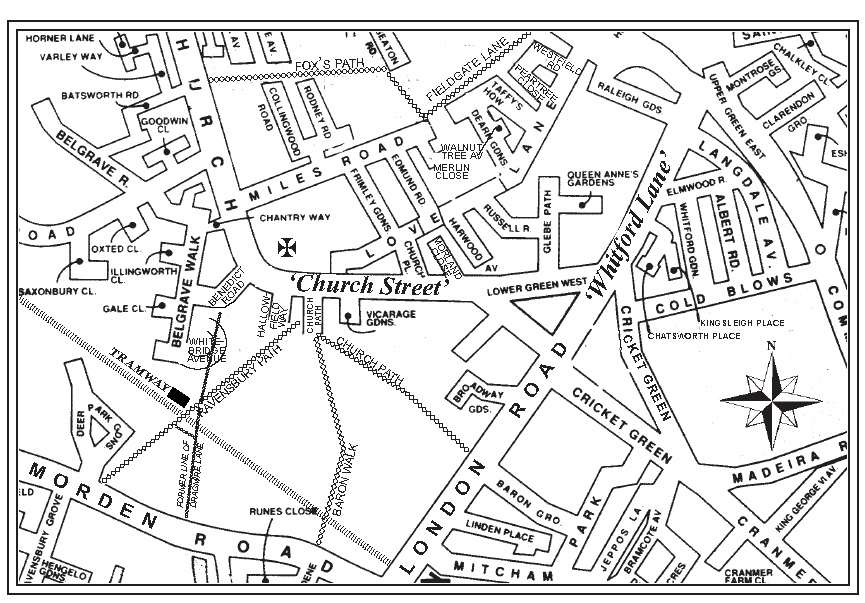
Annotated detail from a modern street map, showing the area covered by this book.
Reproduced by permission of Merton Design Unit, London Borough of Merton
CHURCH STREET AND WHITFORD LANE
My ‘Archaeological Assessment of Church Road’ was produced hurriedly
in January 1995 in case an appraisal of the archaeology of Church Road
was required in discussions on a Conservation Area Partnership Scheme
thentakingplacebetween officers oftheLondonBoroughofMertonand
English Heritage. In the event the assessment was not required, though
the five-year partnership scheme, which was designed to encourage
rehabilitation of properties in the Conservation Area, effectively
commenced in April 1995. The assessment remained unpublished so,
rewritten, it has been incorporated in this volume. The results of one
further study, relevant to the whole area but not widely available, have
also been included in this volume. This is a history of the Church and
the ancient ecclesiastical parish of Mitcham.
The remaining chapters bring together all that I had been able to glean
from the more readily available local sources at the beginning of the
present century. Much more could be done, especially on the more recent
histories of individual properties and commercial concerns. This, I feel,
has to be left to others more intimately connected with the area and its
continuing development.
Finally, I must acknowledge most sincerely the invaluable contributions
of fellow members of Merton Historical Society – Judith Goodman,
David Haunton, Peter Hopkins, John Pile and Tony Scott – in revising,
correcting and reordering my original text to produce a coherent study
of what is historically one of the most fascinating areas of Mitcham.
Eric N Montague (2011)
Imperial Measures are used in most sections of this book
1 acre = 4 roods = 160 square rods, poles or perches = 0.4047 hectares
1 rod = 5.5 yards = 16.5 feet = 5.0292 metres
1 yard = 3 feet = 36 inches = 0.9144 metres
1 mile = 80 chains = 1.61 kilometres
£1 = 20s (shillings) = 240d (pence)
1 gallon = 4.5 litres
CONTENTS
1 CHURCH ROAD: AN ARCHAEOLOGICAL ASSESSMENT …… 1
The Roman Period………………………………………………………………………. 1
The ‘Dark Ages’…………………………………………………………………………. 3
The Later Saxon Period……………………………………………………………….. 5
The Middle Ages ………………………………………………………………………… 9
The Early Church ……………………………………………………………………… 11
Church Street – An Example of Medieval Planning? …………………….. 13
2 MITCHAM IN 1291………………………………………………………………… 17
The Settlement and its Economy…………………………………………………. 17
The People……………………………………………………………………………….. 19
The Landlords ………………………………………………………………………….. 21
3 GUIDE TO THE PARISH CHURCH OF ST PETER AND ST PAUL…..25
An historical introduction…………………………………………………………… 25
Features of the church today ………………………………………………………. 36
4 CHURCH STREET AND THE MANOR OF VAUXHALL ………. 49
5 CHURCH STREET: A PERAMBULATION ……………………………. 51
The Southern Side …………………………………………………………………….. 51
The Northern Side …………………………………………………………………….. 67
No. 66 Church Road………………………………………………………………….. 71
Nos. 60-64 Church Road……………………………………………………………. 71
Nos. 54-56 Church Road……………………………………………………………. 81
Nos. 48-52 Church Road……………………………………………………………. 81
Nos. 42-46 Church Road……………………………………………………………. 83
Nos. 34-40 Church Road……………………………………………………………. 84
The Bull Public House, No. 32 Church Road ……………………………….. 85
6 LOVE LANE AND GLEBELANDS…………………………………………. 89
7 LONDON ROAD alias WHITFORD LANE …………………………… 105
8 LONDON HOUSE ………………………………………………………………… 113
APPENDIX I:
AUTOBIOGRAPHY OF A MITCHAM WORKING MAN………….. 121
APPENDIX II:
CHURCH STREET IN 1838 AND 1846 ………………………………………. 126
ABBREVIATIONS, NOTES AND REFERENCES ……………………… 128
INDEX……………………………………………………………………………………….. 141
CHURCH STREET AND WHITFORD LANE
ILLUSTRATIONS
Engraving of Mitcham old church, west end, c.1790 …………………….. Cover
Detail from John Rocque’s map of 10 miles around London 1741-45………ii
Detail from a modern street map, showing the area covered by this book ….. v
Detail from the Tithe Map of 1847 ……………………………………………………… 6Detail from the 25-inch Ordnance Survey map of 1867 ………………………. 14
Mitcham old church – from the south, c.1800 ……………………………………. 23
Mitcham old church in 1800 – north-east ………………………………………….. 24
Mitcham old church in 1800 – north-west …………………………………………. 24
Mitcham old church, south-east side, 1800 ……………………………………….. 29
View of Mitcham old church and vicarage, c.1822 …………………………….. 31
Mitcham Parish Church, c.1825………………………………………………………… 33
Mitcham Parish Church, June 1988……………………………………………………37
Mitcham Parish Church under repair, 1987 ………………………………………… 38Piscina, south wall of tower …………………………………………………………… 44
Interior of Mitcham Parish Church, 20 March 1948 ……………………………. 46
Hall Place archway in the grounds of Ravensbury School, 1972……………50No.13 (now 19/19A) Church Road under restoration, 1992………………….. 54Old Mitcham Vicarage, 1823 …………………………………………………………… 56Maple Terrace and John’s Place, Church Path, 1992…………………………….59Benedict School – the Lower Mitcham Board Schools of 1897, c.1990 ….. 65
Nos.45-47 Church Road awaiting demolition, August 1992…………………. 66
The Mortuary Chapel, c.1990 …………………………………………………………… 68
Nos.80-82 Church Road, October 1997 …………………………………………….. 68
No.66 Church Road, May 1966 ……………………………………………………….. 70Church House, 64 Church Road, July 1969………………………………………… 72Nos.60-64 Church Road, July 1969…………………………………………………… 79
Nos.54-56 Church Road, December1989…………………………………………… 80
No.46 Church Road, December 1989…………………………………………………82
The Bull and Church Road, c.1900 …………………………………………………… 86
The Bull and Church Road, c.1968……………………………………………………. 86
Lime Villa, 14-16 Church Road, October 1997…………………………………… 88
Cottages in Love Lane, nos.104-106 nearest, May 1966………………………. 91
Cottages in Love Lane, June 1973……………………………………………………..91South-east elevation of Glebelands from the sale particulars of 1841…….. 93
Glebelands and Little Glebelands, June 1967……………………………………… 96
Two views of Rose Cottage, March 1997………………………………………….100Laburnum Cottages, Love Lane, April 1972 …………………………………….. 103London Road (Whitford Lane) looking north, 1893 ………………………….. 104London Road from Upper Green, June 1974…………………………………….. 104Mitcham Citizens’Advice Bureau, London Road, Autumn 1989…………109
Sibford, London Road, Autumn 1989………………………………………………. 109
The Glebe Court Estate, c.1960 ………………………………………………………. 111
London House – a watercolour, c.1830 ……………………………………………. 112
The London House Stores, c.1910…………………………………………………… 112
Century Road, 1973 ……………… ……………………………………………………… 120Mitcham Parish Church, west end, c.1870 ………………………………………. 139
Detail from the 25-inch Ordnance Survey map of 1895……………………… 140
Chapter 1
CHURCH ROAD:
AN ARCHAEOLOGICAL ASSESSMENT
The stretch of Church Road leading from Lower Green West to the
parish church of St Peter and St Paul is included within the Merton
(Mitcham Cricket Green) Conservation Area declared by the London
Borough of Merton in 1969. If an acceptable solution is found to the
problem caused by heavy through traffic, it has the potential, recognised
in proposals adopted by the Council in 1994,1 to become once more a
visually attractive corner of Mitcham. It is certainly interesting, both
archaeologically and historically, and there is justification for believing
that the area around the church may have been occupied continuously
for close on 2,000 years. Moreover, although the evidence is still
fragmentary, excavations have led to a better understanding of the
origins and development of what, in the 12th or 13th century, seems to
have been emerging as the nucleus of a typical medieval village.
Today Church Road continues past the parish church to meet Western
Road and Liberty Avenue at the northern limit of the medieval parish – the
‘Michamingemerke’, or boundary of the people of Mitcham, mentioned
in a Saxon charter of AD9672 – but until the middle of the 19th century
the road beyond the church was little more than a bridleway leading
through thefields to Merton. Acentury ago thatpartof Church Road now
lying within the Conservation Area became known as ‘Church Street’
and, to avoid confusion, this name was used for the purposes of a brief
study compiled by the writer in November 1994. The original version
was revised and expanded in January 1995 as a’desk-top’archaeological
assessment for the use of the Planning Department of the London
Borough of Merton and English Heritage, who in 1994 had entered into
a partnership scheme with a view to giving a degree of priority to the
rehabilitation of properties in the Church Road/Lower Green West area.
The Roman Period
Excavations conducted by the former Museum of London Archaeology
Service (MoLAS) in 1989 to the east of Benedict Primary School and
immediately to the north of Ravensbury Path produced evidence, from
the infill of two substantial ditches, of occupation during the late 1st
to 3rd centuries in the form of numerous sherds of Romano-British
CHURCH STREET AND WHITFORD LANE
pottery, together with imported amphorae and Samian ware. The ditches
had an east–west alignment, and continued beyond the area excavated,
indicating that further archaeological work would be justified should
the opportunity occur. The limited extent of the excavation, plus the
truncated state
of the ditches, rendered interpretation difficult, but in
his report the excavator expressed the view that their purpose may have
been for drainage.3 An alternative interpretation is that they formed part
of a roughly circular ditched enclosure.
One third of a mile to the north-west, on the site of what was to become
Haslemere Primary School (previously occupied by the Short Batsworth
allotments), ditches containing lst- to 2nd-century pottery
and three
inhumation burials were excavated by the writer and members of Merton
Historical Society in 1965-6.4 Further work by MoLAS in 1993 on
adjoining land disclosed another 12 burials lying within what now seems
to have been either a cemetery enclosure defined by a ditch, or else a
roadside burial ground to the west of a north-south trackway.5 Roman-
style pottery was also found in the ditches during the latter excavations,
and although none of the individual graves has been dated, the evidence
points to the burials having taken place during the Roman period. In
accordance with the practice of the time, the cemetery would have been
located a little away from the main area of settlement, which has yet to
be identified. ARoman well was discovered at the gasworksin Western
Road in 1882,6 andotherpossibleRomano-Britishhabitationsites have
been indicated by finds of occupational debris within the radius of one
mile of the church,7 but unfortunately none was excavated fully or to
modern professional standards.
The evidence thus points convincingly to people living in this part of
Mitcham throughout the four centuries of the Roman period, probably
as family groups in widely dispersed farmsteads. This scattered
community, presumably of native stock, is likely to have had some
sub-tribal cohesion, perhaps focused on the homestead of a leading
family able to afford tableware from Gaul and imported wine, and
probably living in a lightly defended enclosure. The indications are that
such a homestead existed close to the site chosen centuries later for the
establishmentof aChristian church. Significantly,itis also closeby that
we find the ‘Blacklands’of a medieval open-field system to have been
CHURCH ROAD: AN ARCHAEOLOGICAL ASSESSMENT
located. In this south-western corner of the future parish of Mitcham
the deep loamy soils overlying the sands and gravels of the Wandle
floodplain are at their most fertile and, easily worked, they would have
lent themselves ideally to an economy based on mixed agriculture and
animal husbandry conducted in the native Iron Age tradition.
The ‘Dark Ages’
Continuation of occupation in the neighbourhood during the immediate
post-Roman period – the so-called Dark Ages – can also be assumed,
although habitation sites with their middens and domestic debris have so
far eluded recognition. That a population of modest proportions persisted
in the general area into the 5th and 6th centuries is, however, confirmed
by the relatively large ‘Anglo-Saxon’cemetery located either side of the
eastern end of Morden Road, and excavated in the early years of last
century.8 Significantly, several of the graves contained material of Roman
origin, including a fineglass ‘amphora’, and thelikelihood is thatmany of
the people interred were of mixed Romano-British and early Saxon stock.9
Immediately to the south of Mitcham parish church a decorated bronze
bowl was discovered in the 1860s, probably during the construction of a
row of cottages known as John’s Place, Nos. 2-20 Church Path. The bowl
was of a Saxon type closely paralleled by vessels from widely scattered
migration-period sites in north-western
Europe,
as well
as in
south
eastern Britain. It can be seen as a symbol of status, and the grave from
which it came would have been that of an individual of some importance
in the community. Not infrequently burials of this nature were marked
by a low earthen mound or barrow, but there is nothing to show that
such a feature once existed here. The close proximity of the church to
the burial may, of course, be coincidental, but it was quite common for
land already regarded with reverence as an ancestral burial place of the
community to be used later for the erection of a preaching cross or early
church. In his letter to Bishop Mellitus (who was to join theAugustinian
mission to Britain in about AD600) Pope Gregory advised that ‘pagan’
shrines (and by implication sites sacred to the local populace) should not
be destroyed but sanctified and used for Christian worship. With this in
mind it is also interesting that a bowl similar to the Mitcham example
was found in a 6th-century Christian grave in a Rhineland churchyard.10
CHURCH STREET AND WHITFORD LANE
The first documentary references to ‘Micham’occur in three so-called
charters of the abbey of St Peter at Chertsey, at one time claimed to
be copies of original documents of AD675 and 727. They are now
believed to have been the work of 13th-century scribes and have been
shown to be forgeries. There is no independent evidence to show that
Chertsey Abbey possessed land in Mitcham, but the possibility that it
did cannot be ruled out entirely.11 In its earliest form, the place name
contains firstly the Old English element ‘mic’, meaning ‘big’. The
second component could be either ‘ham’or ‘hamm’; the two are difficult
to distinguish, and have different meanings. ‘Ham’ may be interpreted
as signifying a place of abode, a settlement or village, and can also be
used in the sense of an estate. Consequently local historians in the past
have customarily translated ‘Micham’ as ‘big home’ or ‘big place’.
However, an alternative interpretation is equally plausible, in view of
the local topography. Amongst its various meanings, the place-name
element ‘Ham(m)’ occurs where land was perceived as lying within
a bend in a river, or for an area of valley bottom land surrounded by
higher ground. In this sense ‘Micham’ could be seen as conveying the
idea of an expanse of relatively flat, low-lying land enclosed by a bend
in a river (in this case the Wandle) with hills around. Today, as one
approaches Mitcham from the south, descending the incline from Rose
Hill with the hills of Streatham and Norwood visible in the distance,
or views the area from the upper floors of the Civic Centre at Morden,
the description seems particularly apt.12
In King Edgar’s charter of 967, granting the royal manor of Merton to
his comes Ælfheah and his wife Ælfswith,2 it was the river Wandle or
‘Hidebourne’which was acknowledged as defining the south-eastern
border of the estate at the ‘Michamingemerke’ – the boundary of the
people of the great ham. Two hundred years later we have the first
references to the parish of Mitcham, the boundaries of which, in the
vicinity of Merton, continued as late as the mid-19th century to be
defined by the Pickle ditch, a watercourse following what had been
an early channel of the Wandle, alongside Phipps Bridge Road. The
frequency with which ‘Dark Age’ cemeteries in southern England are
found to have been located close to the boundaries of ancient parishes
has led several authorities to the conclusion that the parish itself may
CHURCH ROAD: AN ARCHAEOLOGICAL ASSESSMENT
often have perpetuated an estate or area of land the bounds of which
were already recognised in the late Roman period. This might well have
been the position at Mitcham, where the centre of the Anglo-Saxon
cemetery lay within 100 yards (90m) of the Wandle, which still defines
the southern boundary of the ecclesiastical parish.
The Later Saxon Period
It can be seen from large-scale maps of Mitcham produced in the
mid-19th century13 that up to 150 years ago the area to the south of
the parish church was the focal point of a number of footpaths and
bridle ways, although their original courses have long been distorted
by diversions and closures. Today, evocative names like Dragmire
Lane14 may have fallen into disuse, but in their modified form several
of the old paths can still be recognised in their modern guises as
Baron Walk, Benedict Road, Ravensbury Path, Church Path and, of
course, both arms of Church Road itself. Baron Walk, or rather its
predecessor, provided the most direct route to the ford across the
Wandle by the Domesday corn mill of Witford.15 Dragmire Lane,
connecting Benedict Road with Ravensbury Path, led to the centre
of the Dark Age cemetery, whilst Ravensbury Path provided the most
direct route to Morden. Benedict Road, which then continued beyond
the railway (now the tramway), followed the route of an old road south
to what, until the mid-18th century, was another river crossing close
by the site of Ravensbury manor house.
It is also apparent on these early maps that the point of convergence of
the various lanes and paths was a roughly circular area of land, divided
into two since the beginning of the 19th century when it was crossed
by the track of the Surrey Iron Railway, but originally one enclosure.
On the tithe map of 1847 (see extract overleaf) it can be seen as plots
1197 and 1198, whilst on the Moore Estate Sale Map of 1853 the two
are shown as Lots 5 and 6. The ditches and pottery of the Roman period
found by MoLAS in 1989 were from the southern tip of plot 1198
but plot 1197 – later occupied by the yard and buildings of Benedict
Primary School – is, or was, likely to contain similar evidence of early
occupation. It was also on plot 1198 that the early Saxon bowl was
discovered in the 1860s (see page 3).
CHURCH STREET AND WHITFORD LANE
Annotated detail from the Tithe Map of 1847,
copyright Surrey History Centre, reproduced by permission
1437
951
The West Field
LoveLane
CHURCH ROAD: AN ARCHAEOLOGICAL ASSESSMENT
In a second trench excavated by MoLAS in 1989, at the northern
extremity of plot 1198, two ditches containing pottery of the 10th and
11th centuries were found, and a third which was dated to the later
medieval period. Again, the area excavated was limited in extent, but
in this instance the excavating archaeologist concluded that the ditches
were probably defining an enclosure. As in the case of the trenches
uncovered to the south of the plot, the alignment was roughly east-west,
but with a tendency to curve away towards the south.
The implication, clearly, is that the boundaries of plots 1197 and 1198
were delineated by ditches, and that the whole enclosure (for want of a
better term), roughly three acres in extent, was either occupied or had a
special significance in Roman times and continued in use into the late
Saxon period. Significantly, the ground here was fractionally higher
than that to the west and north-west – an important consideration
when the combination of a naturally high water table and a river not
far away probably made flooding an annual hazard. Excavations by
MoLAS in 1992 in advance of redevelopment of a site parallel to
Church Road and to the north-north-west of the enclosure disclosed no
archaeological features, and produced no occupational debris, lending
support to the belief that this area remained open agricultural land until
used for the building of cottages and shops in the mid-19th century.16
Our information is insufficient to indicate whether or not the ditched
enclosure continued to be used into the fifth or sixth centuries, but the
absence of further burials suggests it may have become disused by
about AD600. The evidence of late Saxon pottery and the survival of
the ditch does, however, hint that a century or so before the Norman
Conquest it was still a site of significance, and perhaps a meeting
place of the folkmoot.
Today the western boundary of the enclosure is still followed by the
railings curving around the playground of Benedict Primary School
and, beyond the school entrance, by the old kerb line of Benedict
Road as far as the caretaker’s house and Ravensbury Path. To the east
and south the limits of the enclosure are less obvious, having been
distorted and obscured by buildings and roadworks. They are, however,
followed roughly by Church Path as far as Ravensbury Path, and then
by a footpath, which followed the southern boundary.
CHURCH STREET AND WHITFORD LANE
So little is known of the form taken by early villages in Surrey that any
further comment is bound to be speculative. Where excavation has been
possible, some Saxon villages have been found to comprise a cluster of
timber buildings, a few having the plan of aisled halls, whilst others,
smaller in area, were erected over shallow depressions the precise purpose
of which is still debated. Neither form of construction leaves evidence in
the ground capable of surviving anything but the most shallow ploughing.
The tithe apportionment of 1846 records plot 1197 as “orchard” and
1198 as “buildings and land”, and by 1894, excluding the land occupied
by what are now Nos. 2-20 John’s Place, the two plots combined were
being cultivated as allotment gardens. Although much evidence of early
occupation of the site will have been destroyed unwittingly over the
intervening centuries, the work of MoLAS in 1989 demonstrated that
here and there deeper features can still be expected to survive within the
enclosure. Any future development ought therefore to be preceded by a
thorough archaeological evaluation if the remaining evidence is not to be
lost. This is, in fact, the policy adopted by the London Borough of Merton,
and in the summer of 1996 preliminary excavations in the grounds of the
vicarage prior to development produced evidence of ditches containing
late Saxon and early medieval pottery, plus a contemporary refuse pit.17
Further work by Thames Valley Archaeology Service in 2000 produced
some 100 sherds dating from the Roman period through to late Saxon.
We now need to consider the ancient field pattern revealed in the tithe
map and other mid-19th-century maps (see extracts on pages 6 and 14).
Here one sees an arrangement of plots and enclosures to the north of
Church Street and to the east of Church Road which had been determined
by the boundaries of the extensive open field system known collectively
as the West Fields, or ‘The Blacklands’. As we have already noted, such
field systems were a common feature in medieval England and their
origins are still debated, but there is general agreement that they are
pre-Conquest, and probably Saxon in date. Tenure and cultivation of the
basic strips or ‘lands’, approximately one acre each, into which the fields
were divided, was customarily governed by time-honoured local practice,
with disputes being decided by the village moot. Some amalgamation
and rationalisation of the individual holdings obviously occurred over
the centuries, but the essential outline of the large unfenced furlongs,
CHURCH ROAD: AN ARCHAEOLOGICAL ASSESSMENT
separated by their headlands and sidebalks, endured in Mitcham until the
end of the 19th century. Today former individual strip holdings can still be
identified, fossilised in roads like Frimley Gardens, and Edmund, Rodney
and Collingwood Roads, whilst the old waybalks or headlands, where
medieval ploughmen rested their ox-teams before coming round to turn
another furrow, survive as roads like Love Lane, Fieldgate Lane and Fox’s
Path, their names evoking visions of a rural landscape long since gone.
Unlike many parts of the country, Mitcham did not experience wholesale
enclosure of its open fields, and the unusually late survival of the
underlying structure of the West Fields owes much to their extensive use
as ‘garden grounds’ for the raising of medicinal and aromatic herbs from
the early years of the 18th century through to the late 19th, by which
time market gardening had become the mainstay of many smallholders,
and building development was beginning.
The Middle Ages
Not all the furlongs were to survive intact for so long, however, and there
are grounds for suspecting that one of them, roughly 400 feet wide and
lying to the south of Love Lane, probably ceased to be part of the open
field system in the 12th or early 13th century. What seems to have been
its southern edge can still be traced on 19th-century maps as the rear
boundaries of the vicarage garden and other properties fronting Church
Street. In the grounds of Hall Place the same alignment was continued
by the fences and hedges separating an orchard and other parts of the
gardens as far as Lower Green West.
To the rear of Hall Place itself, excavations in 1966 and 1968 produced
a substantialquantity of whatis often classed broadly as ‘Saxo-Norman’
pottery. Much of this material comprised broken domestic cooking pots
and storage jars in shell-tempered or plain grey ware, and came from the
fillof aditch sealed beneath alater chalk and flintwall.18 The excavation
was conducted in what had been the back garden of Hall Place, built in
1867 following demolition of an earlier Hall Place on the same site.19
From watercolours and contemporary descriptions the older house is
known to have incorporated a fine medieval open hall, a feature only
found in buildings occupied by persons of local importance. An archway
preserved in the school grounds stands on the footings of a private chapel,
CHURCH STREET AND WHITFORD LANE
added to the Hall in about 1349 when it was the property of Henry de
Strete, a London vintner.20 As late as the 1890s the meadows, orchards
and gardens of Hall Place retained the characteristically rectangular
outlines of old enclosed land – the ‘inland’ commonly found surrounding
an early medieval manor house or farmstead.
The ceramic evidence from the excavations demonstrates convincingly
that the site was occupied in the 11th and 12th centuries, and hints that
the medieval Hall Place may have replaced an even earlier building of
pre-Conquest date. The site is therefore one of considerable historic
interest, and, once again, it needs to be stressed that full archaeological
evaluation should precede any further building or landscaping works.
Apart from a possibility that Chertsey Abbey held land in Mitcham, the
earliest known landowners in Mitcham are the Saxon thegns recorded as
holding estates during the reign of Edward the Confessor, immediately
before the Norman Conquest. Of these Aelmer, who amongst other
properties in Surrey held an estate “in Wallington Hundred” of about
270 acres, seems by a process of elimination to be the most likely
owner of a house on the Hall Place site.21 Living on the estate were
four smallholders and nine cottagers, with their respective families. The
tenants had use of three ploughs, which indicates the existence of quite
extensive arable land, as one might expect in this part of Mitcham, and
there were also nine acres of permanent grass, probably on the banks of
the Wandle where they would have been subject to flooding.
Like most Saxon land holders, Aelmer was dispossessed after the
Conquest, and his estate passed into the possession of the Count of
Mortain, one of the great Norman landowners. Within 20 years Mortain
was out of favour, having sided with Robert of Normandy in his dispute
with Henry I over the right of succession to the throne, and his English
estates were confiscated following the battle of Tinchebrai in 1106.
Aelmer’s former Mitcham holding, by this time administered as a tithing
of Mortain’s manor of South Lambeth, passed to the de Redvers family.22
As a constituent part of what became known as the manor of Vauxhall,
the Mitcham property remained in the de Redvers’ hands until lordship
of the manor reverted to the Crown in 1293.
CHURCH ROAD: AN ARCHAEOLOGICAL ASSESSMENT
The Early Church
No church was recorded in Mitcham during the survey conducted on
William I’s orders in 1085, but this need not lead us automatically to the
assumption that no place of worship existed, for several Surrey churches
can be demonstrated from structural evidence to have existed early in
the 11th century and yet failed to be noted by the King’s commissioners.
It has also been shown that it was not unusual for a parish church to have
been preceded by a simple preaching cross, fragments of which might
later be incorporated within the church structure.23 Whereas no physical
evidence for such a cross has been found at Mitcham, there is record of a
cross standing in the mid-12th century. Adeed of c.1150-1170 confirmed
the gift by Robert de Whitford of various plots of land in Mitcham,
including “one acre where Galfridus lives beside the cross”, to the “church
of St Mary of Southwark and the Canons thereof”.24 In a similar deed of
about the same date John de Whitford confirmed the grant, describing the
land as one acre “on which Galfridus built”.25 Both documents mention
the church of St Peter at Mitcham, and make provision for candles to be
provided with the income from lands granted from de Whitford’s estate.
Roadside and boundary crosses were common before the Reformation
and, apart from these references to Galfridus and his house, there is
nothing to indicate where the Mitcham cross was standing. It had
clearly not been removed before the church of St Peter was built, and it
is reasonable to assume it was in a prominent place close by. A possible
clue to its location is an isolated plot of vicarial glebe, slightly under
one acre in extent, shown on all the mid-19th century maps, lying
200 yards south-west of the church. It abuts the ditched enclosure to
which reference has been made earlier, and could, conceivably, have
been part of the de Whitfords’ estate, which included much of Lower
Mitcham. The land can be identified today as the playing field of
Benedict Primary School, bounded by the newly diverted Benedict
Road and Belgrave Walk. It is shown as “meadow” in the tithe survey,
and appears not to have been built on since that time. If it is, indeed, a
remnant of the acre “on which Galfridus built”, excavation might well
produce evidence of occupation in the mid-12th century. The site of the
cross could then be taken to have been within the ditched enclosure,
CHURCH STREET AND WHITFORD LANE
perhaps somewhere on the land covered by the school buildings. A
site such as this might well have been used as the customary meeting
place of the folkmoot, as we have already suggested, in which case its
choice as the position for a preaching cross is what one would expect.
The juxtaposition of a parish church with an early settlement and
burial site is not uncommon in the British Isles. There are, for instance,
remarkable parallels between the siting of Mitcham parish church
near a ditched enclosure and examples quoted by Rodwell from the
Channel Islands, in several of which there is also an association with
standing crosses.26 Closer to home, the parish churches at Old Malden
and Ashtead both stand within, or next to, pre-Christian enclosures.
If the early years of the parish church in Mitcham remain somewhat
uncertain, there is, as we have seen, indisputable documentary evidence
for the existence of a place of Christian worship, dedicated to St Peter,
by the mid-12th century.27 Grant of the advowson of Mitcham to the
prior and convent of St Mary at Southwark in 125928 was confirmed the
following year by Baldwin de Redvers, the eighth earl of Devon and
Wight.29 For the next 300 years the right of presentation to the benefice
was exercised by the priory.
By the close of the 13th century the little Norman church of St Peter
must have been rebuilt, for watercolours and engravings of the medieval
structure, which was largely demolished and rebuilt in 1819/22, show it
externally to have had many features in the Early English style, current
in the mid- to late 13th century. Only the lower part of the medieval
tower was retained during the 19th-century reconstruction and, within
the sacristy and the room above, the original walling of roughly knapped
flint, hard chalk and Reigate stone rubble can still be seen. Parts of the
13th-century chancel arcading and a piscina of the 14th century, now
inset in the outer wall of the sacristy, also survive.
“Hugh at Church”, who we can assume was the priest, is listed as a free
tenant of Baldwin de Redvers in 126230 and the “ecclesia de Micheham”
appears in the bishop’s register of c.1270.31 A “Hugh de Guldeford” is
the first priest whose formal institution and subsequent admission to
the vicarage is recorded, the event taking place in 1291, the year Pope
Nicholas IV’s valuation assessed the tithes due to the rectory of Mitcham
as being worth 20 marks, and the amount due to the vicarage as 8 marks.32
CHURCH ROAD: AN ARCHAEOLOGICAL ASSESSMENT
There can be no doubting, therefore, that the present church stands on
or near a site long used for worship. Its origins may be obscure, but
the likelihood remains that it had its beginnings, albeit humble, in the
Saxon period. This is far from saying that a church was standing here
before the Conquest, and it has to be acknowledged that St Peter’s could
well be a post-Conquest foundation, perhaps, like many Surrey parish
churches, established initially in the early 12th century as an estate
church by a local landowner. The evidence, such as it is, suggests that
in Mitcham this could have been a member of the de Redvers family.
Church Street – An Example of Medieval Planning?
The orderly arrangement of long, narrow house plots or ‘tofts’ in a
rectilinear ribbon development along one or both sides of an axial main
street, with a back lane separating them from, and giving access to, an
open common field, is typical of many villages and small towns which
emerged during the early Middle Ages, when there was a general trend
towards nucleation of the village in lowland England.33 The parish
church with its burial ground at one end of the street and, nearby, the
house of the lord of the manor or an equally important person are other
recurring elements in the pattern.
This is the regular grouping which can be detected in Mitcham, where
narrow house plots front the northern side of Church Street between the
church and Church Place, and in a few instances on the southern side as
well. Other elements of the stereotype are in place: a back lane – Love
Lane – beyond which were the unenclosed west fields, and the parish
church and an imposing hall house at either end of the village street. This
is not all, for the manorial waste, now the Lower Green, extended away
to the east, providing common grazing, whilst a bridle track (still extant
as Cold Blows path) crossed a corner of the main expanse of Common
and led directly to the East Fields, the second of Mitcham’s great open
field systems.
It seems most unlikely that such an orderly disposition could have
emerged entirely from the unco-ordinated activity of a medieval peasantry.
The house plots and the village street have the appearance of being laid
out across one of the furlongs, over which various individuals would
CHURCH STREET AND WHITFORD LANE
Detail from the 25-inch Ordnance Survey map of 1867
CHURCH ROAD: AN ARCHAEOLOGICAL ASSESSMENT
have claimed rights, and such an arrangement can only be the result of
deliberate planning. It is also difficult to imagine how it could have been
effected without the intervention of someone with the overall authority
and determination to override the inevitable objections to change.
The transformation is most likely to have occurred following the
appearance of a new landlord prepared to disregard local opposition,
and could reasonably be attributable to one of the de Redvers who, as we
have seen, had held the tithing of Mitcham since the early 12th century.
An explanation for the scheme being abandoned before completion on
the south side of the road could well lie in the death of the prime mover,
or some equally dramatic change in the family’s fortunes, such as that
leading to the return of the estate and manor to the Crown in 1293.
The names of 16 of Baldwin de Redvers’s Mitcham tenants, each renting
half a virgate, or about 14 acres of land, were recorded at the inquisition
post-mortem held following his sudden death in 1262, but the location
of their houses is unknown.30 It is, of course, conceivable that they were
living in the dwellings ranged along the new main street of the village, but
this has to remain pure speculation. Many of the house plots now fronting
Church Street will have been modified since they were first set out, but
property divisions are well-known to persist unchanged for centuries,34
and a few in Church Street may still observe at least one of their original
boundaries.That this is, indeed, the case is supported by the fact that the
names of several men recognisable as residents of Church Street in the
latter half of the 18th century appear as jurymen in the court leet books of
the manor of Vauxhall.35 Some also occur, either as freeholders or copyhold
tenants of the manor, in rental lists of the same period, but only in the case
of Samuel Oxtoby, a local builder, can one indicate the actual property
occupied. The earliest date we have for any of the houses still standing is
1742,36 before which their history is still obscure.
With only a few exceptions, it has not so far been possible to conduct
a detailed archaeological excavation of any of the house plots, but the
likelihood is that wells, cesspits and other buried features survive and
contain domestic refuse dating to the 13th or 14th centuries.37 This
assumption was given encouraging support by exploratory excavations
carried out by AOC (Archaeology) Ltd in 1996 close by the junction of
CHURCH STREET AND WHITFORD LANE
Love Lane and Church Street. This was the site of two cottages numbered
80-82 Church Road and, although recent use of the land for industrial
purposes had suggested that little of archaeological significance would
remain, a pit containing a significant assemblage of medieval pottery
was uncovered. The most interesting deposit consisted of sherds from a
single cooking pot of South Hertfordshire greyware dated to 1150-1300.
Other pottery fragments in the primary fill included early medieval ware
(c.950-1050), whilst the remainder of the pit contained a mixture of early
medievalsherds.Thepitwas truncatedwith’plough-soil’,i.e.ithadbeen
disturbed by subsequent cultivation, containing cooking pot fragments
and pieces of glazed and slip-decorated London ware of 1200-1350 date.
This is consistent with the land having been used for habitation for a
brief period during the later Middle Ages, when we are suggesting it was
enclosed to create house plots or tofts. The absence of any later material
does suggest, however, that the site of 80-82 Church Road was orchard
or garden ground until the erection of the cottages to be seen in the early
19th-century maps.38
The results of this excavation lend credence to the theory that Church
Street was created in the mid-12th century as part of a planned village.
What remains to be supported archaeologically is the hypothesis that, for
some reason we do not yet understand, expansion of the village failed to
continue beyond the original main street until after the Middle Ages. In
2003 an indication of what may have been the eastern limit of the medieval
development emerged from the work of Compass Archaeology on the
sites of 54-56 Church Road. Nothing was found to show that land this
far from the church had been occupied by buildings until the early 19th
century. This gap in our knowledge is not helped by the apparent absence
of any documentary evidence for the community between the 13th and
18th centuries, although work still to be undertaken on the early records
of the manor of Vauxhall may yet provide the information we need.
As we have stressed already, the whole Church Street area falls within
a recognised zone of archaeological significance in the Borough of
Merton’s Unitary Development Plan, and if what evidence survives
underground is not to be lost, full advantage ought to be taken of
opportunities presented for site evaluation and excavation when any
future redevelopment is contemplated.
Chapter 2
MITCHAM IN 1291
This chapter is based on notes written at the request of bishop Hugh
Montefiore in the spring of 1991, when he was preparing the address
he was to give in Mitcham parish church on the 14 July 1991 at the
service of celebration and thanksgiving on the 700th anniversary of the
induction of Hugh de Guldeford to the vicarage of Mitcham in 1291.
The Settlement and its Economy
The parish of Mitcham in the late 13th century must have presented
many of the features typical of English medieval communities. Although
settlement was still scattered throughout the parish, a movement towards
nucleation was probably becoming evident, with newer dwellings
tending to be grouped around the crossroads at the Upper and Lower
Greens as well as in the immediate vicinity of the parish church. The
pattern of main roads linking these nuclei with the neighbouring villages
is likely to have been well established, and virtually identical with that
of today.
The main economic activity in Mitcham, as in much of Surrey at this
time, was subsistence agriculture and animal husbandry, sheep being
particularly valued for their milk and, above all, their wool, the main
source of the country’s wealth. Two watermills had been recorded in the
Domesday survey, and by the 13th century at least three corn mills were
working on the Mitcham side of the Wandle, whilst there were others
over the parish borders in Merton and Morden. Two of the Mitcham
mills were located in Wicford, or Lower Mitcham, just above the ford
on the road leading south towards Sutton, and a third, held by Merton
priory, was at Phipps Bridge.
The Blacklands, the large open west field on the rich dark loam to the
north of the church would have been cultivated mainly in common
by the villagers, holding unfenced strips allocated in accordance with
ancient custom enforced by the moot, or village council. Another open
common field, the East Fields, lay towards the Streatham border. Many
of the paths and bridleways linking these fields can be walked today,
and some have become roads. Little, if any, of the primaeval ‘wildwood’
once covering much of the area is likely to have survived, but there
CHURCH STREET AND WHITFORD LANE
were certainly areas of secondary woodland, mainly of oak and mixed
deciduous trees on the heavier clays towards Streatham, and willow and
alder on the wetlands in the immediate vicinity of the rivers. Much of
the woodland would have been managed by coppicing and pollarding
to provide timber for building and spars for fencing, whilst a multitude
of uses were found for the offcuts and waste. A ‘hay furlong’ lay to the
north of the road leading westward to Merton, and on the banks of the
Wandle and Graveney there were areas of rich grazing. Finally, on the
poorer gravelly soils to thesouth-eastalargeexpanseof open heathland
or ‘waste’ extended into the parishes of Beddington and Croydon. In
areathis heathamountedto something approachingonefifthor moreof
the total acreage of Mitcham. It was greatly valued by the commoners
as rough pasture and as a source of fuel, and was rigorously defended
against trespass and any attempt at unsanctioned enclosure.
Not all the land under cultivation lay in the open fields and, in addition
to their strip holdings, many of the villagers would also have had
smallholdings, or crofts of enclosed land. There were also the glebe
lands, most likely leased or let to augment the income of the vicarage
rather than worked by the priest himself. Finally in Mitcham there
were several substantial demesne farms, each including not only strips
in the open fields, but also enclosures grouped around the hall and the
ancillary buildings which provided accommodation for the peasants
working under bailiffs responsible for the individual estates. Several
of the old field names, like ‘Battesworth’, meaning ‘Bætti’s enclosure’,
are mentioned in a deed recording a transfer of title in 1234/5, during
the reign of Henry III.1 Batsworth itself lay to the west of Church
Road, and survives as a road name today. Other enclosures from the
mid-13th century havenames like ‘Spirihey’, fromthe Old English spir,
meaning reeds or rushes, with the word hay to indicate an enclosure;
‘Westbroc’, derived from the OE broc implying marshland or a marshy
stream; ‘Bery’ and ‘Burforlang’, possibly from the OE beorg for a hill
or mound – perhaps a hint of a long-lost barrow or burial mound – or
more likely from byrig, originally meaning a stronghold but later used
for a manor house, presumably in the sense of a strongly built house;
and ‘Inlond’, referring to demesne land. All give clues as to their nature
or origins, although none can be located today.2
MITCHAM IN 1291
The People
It is impossible to state with any confidence what the population of
Mitcham was towards the end of the 13th century, but it might well
have been double the 230 or so that can be calculated as living in the
two Domesday vills of ‘Michelham’ and ‘Witford’ or, as we know them
today, Upper and Lower Mitcham.3 Their individual social and economic
standing in the community of course varied, some of the villagers
enjoying the status of freemen, perhaps holding both freehold and
copyhold land. Others, the majority, whose ancestors would have been
classified as villeins and cottars by the Domesday commissioners, had a
more lowly status which probably had not varied overmuch in 200 years.
In the main holding their land as tenants of one or other of the major
landowners in the parish, bound by manorial custom to provide labour
service and meet other feudal dues, these smallholders nevertheless
occupied a position higher than the handful of serfs, who earned their
living as servants or day labourers. All would have asserted with vigour
that they were English rather than ‘French’, a term reserved with some
disdain for the ruling Anglo-Normans, and most would have been of
Saxon lineage, but with a substantial admixture of the far older blood
line of the indigenous British. Their language, although basically
Anglo-Saxon, contained much Surrey dialect, and whereas all would
have been nominally Christian, very few are likely to have been even
partially literate, or able to understand the Latin they heard used in the
services of the church.
For the most part these medieval Mitchamers are anonymous, but the
names of a handful have survived in a rent roll of free tenants of Baldwin
de Redvers, the eighth earl of Devon and Wight, who was poisoned in
a palace plot in 1262:
Hugh at Church John Hevid
Nicholas de Braie William Lankerigo
Walter Godefrith Stephen at Crossholds
Simon Sidhar Robert Aldhever
Nicholas Durant The Heirs of Matthew le Mason
Godfrey Bernand Simon Gnat
John Suenete John Bonde
William Attelhard William Winde
CHURCH STREET AND WHITFORD LANE
The prior of Merton, holding by lease a moiety or half share in the mill
at Phipps Bridge, was also amongst the tenants listed.4
What can be said of the rest of these men? Hugh at Church we may
assume to be the parish priest living in a parsonage house which at
this time seems likely to have been on the site of The Canons we know
today. His holding, or perhaps more accurately (since he would have
had no possessions of his own) land held by the church and in his charge
whilst he held office, was assessed on the basis of one virgate, or very
roughly 25-30 acres. Five other substantial tenants of Earl Baldwin
were holding land of a similar acreage. The name Nicholas de Braie
carries with it an air of social distinction and, coming second in the
tenancy list, Nicholas may have held a position of minor authority,
perhaps as the bailiff. He might even have resided at Hall Place, but
would have been answerable to the steward of Vauxhall, whose periodic
visits were probably awaited with some apprehension. Matthew le
Mason’s surname suggests he could conceivably have been a master
builder, perhaps the craftsman overseeing work on the parish church,
parts of which were very obviously of the late 13th century. As late
as 1990 the telephone directory showed Bonds, Durants, Godfreys,
and even Sidars to be living within a mile or so of the church, and
one wonders how many are actually descended from families who
witnessed the induction of Hugh de Guldeford as the new vicar of
Mitcham on 19 July 1291.
From what we can deduce of the extent of the late earl’s Mitcham
estate, it would seem likely that most of these tenants lived in the
street of small houses and cottages extending eastwards from the parish
church. Even today the boundaries between their house plots or tofts
are still respected by the fences separating several of the properties
fronting Church Road. In their regular layout one feels that here we
can actually detect the hand of one of the de Redvers, indulging like
many landowners in the 12th and 13th centuries in a modest exercise
in estate development and village planning. Significantly, the street
seems to run obliquely across what was once part of the open field
system, hinting that in the cause of progress, ancient patterns of land
tenure had been over-ridden by superior authority.
MITCHAM IN 1291
Quite apart from the administration of the local manor courts and
the hundred court at Wallington, the villagers of Mitcham evidently
maintained a corporate identity and a sturdy independence, glimpses
of which have come down to us. As early as 967 the charter of King
Edgar, granting his estate in Merton to Ælfheah, “a nobleman of this
country”, had recognised the ‘Michamingemerke’ – the boundary of the
people of Mitcham,5 and in the middle of the 12th century the “parish
as a whole” had made a “grant and gift” of land, enclosed from the
common heath, to the priory of St Mary at Southwark.6 This land can
be identified as the site and grounds of today’s Canons, and probably
parts of the adjoining sports and recreational centre. It was here that
the canons from Southwark were to erect their hall and the various
buildings of their grangefarm, and wheretheir fish pond and medieval
dovecot can still be seen. Then again, in 1239, the men of Mitcham
successfully joined forces with the prior of Merton in an action heard
before one of the King’s justices to prevent a Beddington landowner
from excluding them and their cattle from part of Mitcham Common.7
The Landlords
In 1291 there were four main estates or manors in Mitcham, held in
accordance with feudal custom either by tenants-in-chief of the king,
or by men who were sub-tenants of other, superior, land holders.8
John de la Mare, lord of the manor of Ravensbury, held an estate in
Lower Mitcham which encompassed the Domesday holding of William
the chamberlain, the tenant of William fitz Ansculf, sheriff of Surrey.
The manor extended north as far as Church Path, and included not only
today’s Ravensbury Park but also much of the land on the north bank
of the river Wandle between Phipps Bridge and Willow Lane. The de
la Mares owned a mill, possibly sited above Mitcham bridge near the
Whitford or Mitcham mill, and probably by this time they included
in their tenure the detached farmstead of ‘Jenkingranger’ at Colliers
Wood, which emerges in the court rolls as copyhold of the manor of
Ravensbury, towards the end of the Middle Ages.9 The full extent of the
manor in 1291 is not known, but through the process of sub-infeudation
and outright purchase the de la Mare property was probably already
larger than the original Domesday estate.
CHURCH STREET AND WHITFORD LANE
By the end of the 13th century Southwark priory’s estate in Lower
Mitcham seems to have extended from The Canons southwards to include
the sites of the Wilson Hospital and Cranmer Primary School, together
with land off Willow Lane. The various parcels which comprised this
holding had come into the priory’s hands largely through the generosity
of thedeWhitford family, to whomby sub-infeudation thepre-Conquest
holding of Edmer, a Saxon, had passed via the hands of fitz Ansculf and
his heir, baron de Sumery. A further portion of the priory’s property in
Mitcham was held of the powerful de Clare family, earls of Gloucester,
to whom the Domesday holdings of Odo, bishop of Bayeux, had passed
after the bishop’s disgrace in 1088. Eventually the priory’s lands came
to be regarded as forming the manor of ‘Mitcham Canons’, a somewhat
nebulous entity for which, unlike Ravensbury and the other Mitcham
manors, no court rolls survive.
A substantial part of central Mitcham, extending from the vicinity of the
parish church to Commonside West, and including both halves of the
Lower Green, lay within the jurisdiction of the manor of Vauxhall. As a
tithing or part of their South Lambeth estate it had been held in dower
by Margaret, widow of Baldwin, the eighth earl, following his murder
in 1262. Margaret remarried, taking Robert de Aquilon as her second
husband, and when she died South Lambeth and Vauxhall, including the
tithing of Mitcham, passed to Isabella de Fortibus, widow of the earl of
Albemarle, by her right of inheritance as Baldwin’s sister. Lordship of
the manor was to revert to the Crown in 1293.
Finally, amongst these larger estates there was Biggin in north Mitcham,
certainly in the hands of Merton priory by 1301, and probably already in
their possession by 1291. Like Southwark priory, Merton had attracted
many grants of land since its foundation in 1117, and the priory’s
Mitcham property was emerging as the manor of Biggin and Tamworth.
Although it might appear from the foregoing that towards the close of
the 13th century much of Mitcham fell within the jurisdiction of one
manor or another, the picture is complex and far from complete. The
manors were fragmented and intermingled, and their precise boundaries
are uncertain. No maps or terriers are known, and over much of Mitcham
Common, for instance, the extent of manorial control was ill-defined
MITCHAM IN 1291
and remained in dispute until settled by legislation in the 19th century.
It also needs to be stressed that the surviving records are mainly those
of the major landowners, and that there were certainly a number of
minor land holders in the 13th century to whom we have only passing
references.
The concluding six pages of the notes prepared for Bishop Montefiore
in 1991 are omitted from this collection of studies since they were
concerned with the early history of the parish church of Mitcham, a
subject which is covered by the church guide, published in July 1992
and revised as Chapter 3 of this volume.
Mitcham old church – from the south, c.1800,
reproduced by courtesy of Merton Library & Heritage Service
CHURCH STREET AND WHITFORD LANE
Mitcham old church in 1800 – north-east (above) and north-west (below),
reproduced by courtesy of Merton Library & Heritage Service
Chapter 3
A GUIDE TO THE PARISH CHURCH OF ST PETER AND
ST PAUL
An edited version of the church guide compiled by the author in 1990
and published in July 1992, which did not include footnotes
An historical introduction
Although the Domesday record for Mitcham makes no mention of
a church, omissions of this nature are not unusual, for many village
churches known from indisputable archaeological or documentary
evidence to have existed before the Norman Conquest were not
recorded in the survey of 1086. Mitcham, with its associated hamlet of
Whitford, was already a large settlement by the time of King Edward
the Confessor. It is not unreasonable, therefore, in spite of the lack of
proof, for us to imagine that the spiritual needs of the community might
already have been served by a small church established somewhere in
Mitcham well before Harold succumbed to William of Normandy in
1066. Anything more would be pure conjecture at the present time. It
is tempting, nevertheless, to wonder if this Saxon church could have
owed its foundation to the minster church of St Peter at Chertsey which,
according to the Victoria County History of Surrey, was founded in
AD 666 and claimed to have owned land in Mitcham as early as 675.
Whereas the formalisation of parish structure was probably not
completed until early in the 13th century, many English parishes had
their origins in the late Saxon period, and some can be shown to have
coincided with old estate boundaries. We cannot say if this was the
case at Mitcham, where a parish was certainly recognised by around
1170 and it is intriguing that, at least in part, the boundary of what until
the late l9th century remained the ecclesiastical parish was known in
a charter of 967 as the ‘Michamingemerke’, or boundary of the people
of Mitcham.
The first church at Mitcham of which we have any knowledge was, like
Chertsey Abbey, dedicated to St Peter. It was referred to as “the church
of Mitcham” in a charter of Henry de Blois, bishop of Winchester, who
died in 1172, and was described as belonging, with “its appurtenances”,
to the priory of St Mary at Southwark which, through the generosity
CHURCH STREET AND WHITFORD LANE
of various landowners, had acquired a modest estate in Mitcham since
its foundation around 1106. The church of St Peter had clearly been in
existence for a considerable time, for a grant of land in Mitcham, made
to the priory by Arthur de Whitford around 1120 to ensure an income
to
provide
the
church
with wax
candles, was confirmed
in
various
deeds between 1150 and 1170. Little of substance has come down to
us to suggest the name of the actual founder of St Peter’s, but it may
well have had its origin, as did many parish churches in Surrey, in a
chapel established by a lay proprietor to administer to his household
and the tenants of his estate. Such chapels or churches, usually with an
endowment of land to secure their upkeep, had commonly passed to a
religious foundation by the 13th century.
The 12th-century church at Mitcham would have comprised a very
simple building, similar in plan to a number of contemporary Surrey
churches, consisting of a nave of perhaps 35 to 40 feet in length and
20 feet in width, and a tiny chancel 15 feet square. Construction would
probably have been of hard chalk and flint, and the roof covering of
thatch. The site is not known for certain, and little more can be said
about it. However, since St Peter’s was referred to by bishop Henry as
“the church of Mitcham” (he also spoke of the parish of Mitcham) it
would seem by 1171 to have functioned as the parish church, and is
more likely to have stood on the site of the present church of St Peter
and St Paul than anywhere else in the parish.
A later medieval church, of which we have much more knowledge,
certainly occupied the corner of Church Road where today’s parish
church stands. At first sight the location seems rather isolated from
what one assumes by Tudor times had become the twin focal points of
settlement – the Upper and Lower Greens. This may not signify much,
for the natural, as opposed to planned, nucleation of settlement often
did not materialise until the 13th or 14th centuries. There is, moreover,
the phenomenon of ‘settlement drift’, which can be demonstrated to
have been a common feature in the pattern of development of English
villages. Quite apart from its location close to what would now appear
to have been a pre-Conquest focal point of settlement, the site of the
church at Mitcham also lies close to the most northerly of the burials in
the large Anglo-Saxon cemetery at Ravensbury, which seems to have
A GUIDE TO THE PARISH CHURCH OF ST PETER AND ST PAUL 27
come into use in the early fifth century. On the evidence of grave goods,
it continued to receive interments until Christianity was re-introduced
into south-eastern England by St Augustine’s mission in 597. It was
not uncommon for early churches to be established on or near land
already hallowed by local custom, and the site chosen in Mitcham for
what we may assume to have been an early, perhaps even the first,
place of Christian worship may well have had a special significance
for the community.
Sometime in the mid- to late 13th century extensive enlargement,
if not actual rebuilding, of the church at Mitcham took place, for
engravings and watercolours surviving from the late 18th and early
19th centuries show the old parish church to have retained a number
of features in the Early English style. The church can also be seen from
surviving illustrations to have been extended and altered on a number
of subsequent occasions. The main structure was of a typical Surrey
mixture of flint, hard chalk, and stone rubble, with the use of Reigate or
similar better quality stone being restricted to the external quoins, the
arches and columns of the nave, and the dressings of window and door
openings. In plan the church comprised a nave, two aisles and a chancel,
and there was also a square embattled tower. As in today’s church, this
stood at the eastern end of the south aisle, abutting the chancel, and
by the late 18th century was crowned with a weatherboarded bellcote.
We have no real evidence to show who was motivated to finance the
rebuilding in the 13th century. If we are guided by what happened
elsewhere in the country we should seek a wealthy benefactor who,
typically, would have been in possession of a substantial estate in the
parish. The most likely candidates are the de Redvers family, whose
manor of South Lambeth, which was later to become known as the
manor of Vauxhall, had included some 280 acres in central Mitcham
from the early 12th century. The family, one of the most wealthy and
influential in England, demonstrated their piety by the founding of
several religious houses, and there is circumstantial evidence which
suggests that the rebuilding of Mitcham church might be attributable to
the Lady Amicia, the young widow of Baldwin de Redvers, the seventh
Earl of Devon and Wight, who died in about 1245.
CHURCH STREET AND WHITFORD LANE
As late as the mid-19th century there were extensive glebe lands
belonging to the benefice at Mitcham scattered throughout the parish,
including strips of arable in the west common field. Although the dates
of bequest of these holdings to the church are unknown, it is implied
by Bishop de Blois’charter that the church had already benefited from
gifts of land by 1171. Significantly, perhaps, much of the glebe was
located within the general area of the de Redvers’ Mitcham estate, from
which we may infer that they or their predecessors had been responsible
for some of the earliest grants of land, designed to ensure an income
for the priest as well as to provide for the maintenance of the church.
The advowson of Mitcham, that is, the right to appoint the incumbent,
was granted to the prior and convent of St Mary at Southwark by
Bartholomew ‘de Lisle’in 1259 and this was confirmed by ‘Baldewyn
de Insula’, Amicia’s son Baldwin, the eighth earl of Devon and Wight,
in 1260. Although the priory had, as we have seen, been in possession
of the church of St Peter for over a century, patronage was evidently
retained in the gift of the de Redvers and subsequently their relatives, for
as late as 1315 we find the priory holding the advowson from Gilbert,
the ninth earl of Gloucester.
A ‘Hugh at Church’, described in a rent roll of 1262 as a free tenant of
Earl Baldwin with tenure of a virgate of land, was possibly the parish
priest, presented under the patronage of the family. From the last third
of the 13th century onwards the records of the diocesan administration
become more plentiful. The ‘Ecclesia de Micheham’ was included under
‘Archidiaconatus Surreye. Ewelle’ in a list of churches in the diocese
of Winchester in Bishop John de Pontissara’s register of c.1270, and
Mitcham remained in the deanery of Ewell until the 19th century. The
first vicar actually recorded in the Winchester registers is another Hugh,
styled ‘de Guldeford’, who was instituted on 19 July 129l.
By the 13th century, in addition to many other properties elsewhere in
Surrey, the Augustinian priory of St Mary at Southwark had possession
of agrangefarmatMitcham, thebuildings and fishponds ofwhich were
on the site of The Canons, off the Cricket Green. Over the next three
centuries Mitcham prospered, becoming a favoured place of residence
for city merchants and Crown officials. As was customary, the Church
A GUIDE TO THE PARISH CHURCH OF ST PETER AND ST PAUL 29
received their support during their lifetimes, and often gifts of land
in their wills. Many of these parishioners were buried within the old
church at Mitcham, and a few of their memorials, regrettably stripped
of their brasses either during the Reformation or the Commonwealth,
survived until the church was demolished in 18l9.
Together with the right to an income from rectorial tithes of corn, hay
and other produce of the parish, the benefice remained in the possession
of the priory of St Mary until the dissolution of the monastic houses and
the disposal of their estates by Henry VIII between 1536 and 1539. Both
the rectory and the advowson of the vicarage at Mitcham passed into
lay hands in 1545, but patronage was exercised by Queen Elizabeth I
on one isolated occasion in 1566. Thereafter the vicars were appointed
by private patrons. Robert Cranmer, a merchant of the City of London,
purchased much of the priory’s former estate, including the lordship
of the manor of Mitcham, the rectory and the advowson, in 1656.
Mitcham old church, south-east side, 1800,
reproduced by courtesy of Merton Library & Heritage Service
CHURCH STREET AND WHITFORD LANE
Subsequently part of the rectorial tithes were sold by the family, but
patronage remained in the hands of the Cranmers and their descendants
the Simpsons until the 1930s. Since 1969 the advowson has been in
the possession of Keble College, Oxford. The remaining tithes were
commuted to an annual rental following a survey of the parish in 1846,
payment of which was abolished when Church finances generally were
reorganised in the 1920s and ’30s.
In what is intended as a brief guide to Mitcham church, space does not
permit an account to be given of the difficulties encountered during the
Reformation (when the priest resigned after the imposition of the new
liturgy and the church valuables were sold under compulsion) or the
trauma of the Civil Wars and the religious upheaval that followed. At one
period in the mid-17th century patron and parson were in bitter conflict,
but the church survived, and the large number of monuments from the
early 18th century, still to be seen within and around the church, attest
both to the individual piety of those commemorated and the central
role then performed by the parish church in the life of the community.
On the evening of 14 January 1637 the church was hit by lightning and
set on fire in a great storm during which 13 other Surrey churches were
also severely damaged. At Mitcham four bells were melted, the spire
of the steeple was burnt down to the stonework of the tower and the
whole roof of the chancel destroyed. The church was temporarily out
of use until substantial rebuilding had been completed in 1640. The old
church survived another lightning strike in 1785, when the south wall
of the tower was hit, but this time with little serious damage.
In the latter part of the 18th century the steadily deteriorating state of the
fabric of the church was becoming a source of growing concern (part
of the wall and roof of the north aisle collapsed in 1738), but a final
decision on whether to repair or rebuild was not taken until after the
Napoleonic wars. By this time the increasing population of the parish
made it essential to raise a completely new structure on an enlarged
scale, and an act of Parliament was obtained in 1819 to authorise a
special church rate to meet the estimated cost of £8,000. The initial
expenditure incurred in rebuilding was funded by Hoare’s Bank, the
treasurer of the rebuilding committee appointed by the vestry being
A GUIDE TO THE PARISH CHURCH OF ST PETER AND ST PAUL 31
the bank’s senior partner, Henry Hoare, who lived at Mitcham Grove.
The old church, with the exception of the lower part of the tower up
to the bellringers’ loft, was demolished in l8l9, and rebuilding began
immediately, the first stones of the new structure being laid on 2 August
1819 by the vicar and prominent members of the congregation.
The new parish church, built by John Chart to the design of George
Smith, FSA, FIBA, soon attracted both criticism and praise from
architects and topographical writers of the day. It was, for instance,
derided in 1821 by “E.I.C.” in the Gentleman’s Magazine as a “uniform
piece of carpenter’s gothic”, the “meanness” and “incongruities” of
which “were utterly at variance with every ancient design”. Walford
in his Greater London (1884) considered it to be “in the style of that
most dreary period”, in the beginning of George IV’s reign, “when
‘compo’architects ran riot without fear of censure from a public which
View of Mitcham old church and vicarage – undated and unsigned coloured
lithograph, attributed to Charles Thomas Cracklow c.1822,
reproduced by courtesy of Surrey Archaeological Society (PD/MIT/3)
CHURCH STREET AND WHITFORD LANE
knew little and cared less about the mysteries of the ‘Gothic’ style”. He
conceded, however, that Mitcham church “is by comparison a rather
good specimen of the Gothic of the Georgian era, and seems to have been
erected regardless of expense”. The Greenwoods in Surrey Described
(1823) considered the new church a “neat gothic structure”; Lewis’s
A Topographical Dictionary (1840) found it “handsomely rebuilt in
the later style of English architecture”; but Brayley’s Topographical
History of Surrey (1841) was less enthusiastic, describing it as “a large
and somewhat imposing, but rather heavy structure”.
John Chart, master builder and undertaker, had been parish clerk
and vestry clerk since 1805 – posts to which his late father had been
appointed in 1761, and which he himself held until his death in 1846.
Several delightful anecdotes of the building operation were recounted
by his grandson, also named John, and published in connection
with the church’s centenary. They remind one that despite its quite
impressive scale, and the inspiration so obviously derived from the
great Perpendicular churches of the later Middle Ages, the church
of St Peter and St Paul at Mitcham must still be seen very much as
a village church, lovingly built with unsophisticated local labour in
the true medieval tradition. Chart evidently found the plaster work of
the groined roof very difficult to accomplish, his previous experience
having been restricted to the building of houses. Because of the size
of the timbers used – the beam on which the gallery on the north side
rested was in one piece and far larger than he was accustomed to
handle–a special saw-pit had to be constructed at the rear of his yard
off the Upper Green. The carving of the fronts of the galleries, which
were in solid oak, was the work of Chart’s head carpenter, Vernon
(who played the violin in the church orchestra), and the majority of
the labour employed would have come from his normal workforce.
Chart’s own son, Edwin, later to qualify as a surveyor and himself
to hold office as parish clerk, was employed on the building as an
apprentice carpenter. Chart had a small brickworks off what is now
Sherwood Park Road, and it is likely that this supplied much of the
material used in the ‘brick and compo’construction adopted. The so-
called ‘Roman’ cement used in rendering the structure both inside and
out (only for the pinnacles and finer detail was natural stone used)
A GUIDE TO THE PARISH CHURCH OF ST PETER AND ST PAUL 33
was commonly produced in England from a mixture of lime and (as
a substitute for crushed volcanic ash) finely ground brick or tiles.
Supplies of building lime need have come from no farther than the
nearby Surrey hills.
In view of the defective state of the bells, which it had been intended
should be rehung in the new tower, it was decided in December 1819
that the whole peal of eight should be exchanged for a new peal of
no less weight, and a contract was placed with Thomas Mears, the
bell founder of Whitechapel. The net cost was £239, £336 being the
allowance credited for the old bells. Work was nearing completion
Mitcham Parish Church, c.1825,
reproduced by courtesy of Merton Library & Heritage Service.
This view was published by Cracklow in his Views of all the Churches and
Chapelries in the County of Surrey (in 26 parts) between 1823 and 1827.
CHURCH STREET AND WHITFORD LANE
in April 1821, when the committee met for the first time in the new
vestry room, and one year later, on 14 April 1822, the church was
re-opened for divine worship, the ceremony being performed by the
bishop of London.
The population of Mitcham continued to expand, increasing from 4453
in 1821 to 6498 in 1871. At this time the boundaries of the ecclesiastical
and civil parishes were very much as they had been in the 13th century.
For most of the 19th century the mainstay of the economy was the
cultivation of medicinal and aromatic herbs, for which Mitcham became
famous. Horticulture was also important, and there were several flour,
snuff and felt mills powered by the water of the Wandle. Although the
textile bleaching and printing industries which had flourished since the
16th century declined in the face of changing fashions and increasing
competition from the north of England, the village and its people
happily did not experience the worst effects of the Industrial Revolution.
The parish church at this time provided a social as well as a religious
focal point for the bulk of the community, and continued to attract the
generosity of the wealthier inhabitants.
Substantial changes were in the offing, however, and by 1871 the
expansion of suburban London into Colliers Wood and north Mitcham
necessitated the creation of a new ecclesiastical parish, to be served
by the daughter church, Christ Church, consecrated by the bishop of
Winchester in 1874. The parish was formally created the following
year. Subdivision of the original parish of St Peter and St Paul
continued as the need arose for better provision to be made for the
newcomers who were making Mitcham their home, and 1898 saw the
laying of the foundation stone of St Mark’s church, designed to serve
the new housing estates of east Mitcham. North Mitcham became a
mission district of Christ Church in 1903, for which the new parish
church of St Barnabas was consecrated by the bishop of Southwark
in 1914. The parish of St Mark, assigned to its new church in 1906,
was also to undergo subdivision on the creation of the parishes of St
Olave and the Church of the Ascension at Pollards Hill, formed in
response to the rapid urbanisation of south-east Mitcham which took
place in the inter-war years.
A GUIDE TO THE PARISH CHURCH OF ST PETER AND ST PAUL 35
Mitcham suffered severely during the raids by the Luftwaffe in the
early l940s and the bombardment by German V weapons in 1944 and
’45. Hundreds of houses and many factories and public buildings were
either destroyed or severely damaged, but Mitcham parish church
came through these onslaughts structurally intact. In January 1943,
however, the organ was destroyed and serious damage done to the
interior of the church by a fire started, so it was believed, by a mentally
handicapped boy. Flames drawn through the bell chamber shot 100 feet
into the air, the tower acting as a chimney, and there was a danger of
the bells crashing to the ground. All the records and memorabilia of
the bellringers were lost, five stained glass memorial windows in the
nave were smashed, woodwork was scorched, and much damage was
done by water. Fortunately the plate and registers were saved through
the vigilance of the elderly verger.
Although the church was quickly cleared of debris so that services could
continue, the walls were to remain smoke-stained until well after the
end of hostilities. Eventually war damage repair works were carried
out, and the blackened interior was restored and beautifully redecorated
in time for the celebration of the Festival of Britain in 1951. Two years
later the treble, second, third, fourth and sixth bells were recast and the
peal rehung with completely new fittings and framework by Mears and
Stainbank of the Whitechapel Foundry. The parish registers, dating
from 1563 and largely complete, were transferred to Surrey Record
Office
for safe keeping in 1965, and the
vestry minutes, which are
extant from 1699, passed into the hands of the newly created London
Borough of Merton.
In secular affairs there was now a general feeling of confidence and
optimism in the future. The great social and economic changes of the
preceding 100 years, hastened by the two World Wars had, however,
imposed critical stresses on the established order, and the parish of St
Peter and St Paul was about to enter a very difficult period. Over the
next 20 years the church experienced a steady decrease in the size of its
congregation; it also suffered general structural deterioration through
age and lack of maintenance. To make matters worse, in April 1975,
during a freak storm, the tower was hit by lightning and a turret and
CHURCH STREET AND WHITFORD LANE
part of the crenellation was struck and brought to the ground. During
subsequent structural survey it became apparent that penetration of
moisture, mainly through defective cement rendering, was contributing
to a serious outbreak of dry rot, and the church was temporarily closed
in 1987 to allow extensive renovation work to be undertaken. The
first phase, that of making the roof and upper structure watertight and
replacing decayed timbers and plaster, was carried out in 1988. The
following year an appeal was launched to fund further work to make
the church more welcoming to the people of Mitcham, and bring it more
fully into the life of the community.
Late in 1990 it was decided that the approaching 700th anniversary of
the institution of the first recorded vicar should be marked by a series
of special events. Although the more urgent works of structural repair
had been completed, and interior restoration was well advanced, the
decorative condition of the church remained very poor and, with finance
sorely stretched, seemed likely to remain so for some time. However,
an inspired approach to the British Broadcasting Corporation secured
an unexpectedly generous response, and during the space of a mere 60
hours in June 1991 the interior of the church was transformed. Under the
watchful eye of English Heritage and the television cameras (the whole
operation was the subject of a Challenge Anneka programme shown
the following October) the pine pews were removed and a new wooden
floor installed, carefully raised above the old tomb slabs, the inscriptions
on which have been recorded. The whole floor was covered with fitted
carpet, modern seating provided and the church tastefully decorated in
timefor aserviceof thanksgiving conducted by bishop Hugh Montefiore
on 14 July 1991.
Features of the church today
The plan of the old medieval church at Mitcham appears to have been
quite closely adhered to when the present building was begun in 1819,
and the church today, like its predecessor, consists of a nave with two
aisles, a chancel, a north transept or chapel, and a tower. Below the
wooden decking installed in 1991, set in the floors of the nave and
aisles, are many of the flat grave stones mentioned in descriptions of the
monuments in the old church, which indicates that they, and the vaults
A GUIDE TO THE PARISH CHURCH OF ST PETER AND ST PAUL 37
beneath them, were left undisturbed during rebuilding. If the belief is
correct that the 13th-century church replaced an even earlier place of
worship, then there is a strong possibility that the foundations of this
building also lie beneath the old floor.
The construction of the present church, as we have observed earlier, is
mainly of brick, probably made locally, and rendered both inside and
out in ‘Roman’ cement which was incised with sham joints to simulate
ashlar masonry. On the southern side of the church is the tower, standing
at the eastern end of the south aisle. A more usual position in which to
find the tower would be at the west end, but the somewhat anomalous
position at Mitcham was dictated by the decision to preserve the lower
part of the medieval tower which, when demolition work commenced,
was found to be sound. The present tower is in three storeys, the
uppermost with octagonal buttresses continuing upwards to form four
corner turrets. Originally these terminated in tall ornately carved stone
pinnacles topped with large round finials. Between the turrets there was
also delicate stone tracery in lieu of the more normal embrasures of a
battlemented parapet. This ornamentation, together with some of the
Mitcham Parish Church, June 1988 (ENM)
CHURCH STREET AND WHITFORD LANE
Mitcham Parish Church under repair, 1987 (ENM)
A GUIDE TO THE PARISH CHURCH OF ST PETER AND ST PAUL 39
embellishments of the pinnacles, eventually became unsafe and was
removed in 1899. The pinnacles themselves were finally taken down
in 1956. Today the tower is more simply finished with a crenellated
parapet linking the original turrets.
Viewed from the west today the church sadly lacks the grace and visual
impact of the original design. A wide central archway beneath the great
west window, spanning an imposing entrance porch, was removed
during the creation of the present baptistry in 1875. In the process the
opening was closed, and a row of five rather tasteless pointed windows
(two of them blind) was inserted between the end buttresses of the nave.
The effect of these alterations, together with the later removal of the
pinnacles from the end of the nave, has been disastrous aesthetically, and
the western façade of the church has now completely lost the emphasis
the architect obviously intended. The east end of the chancel was also
once topped with heavily decorated pinnacles, one on each side, and
one in the centre. Their loss apart, this end of the building is still very
much as it was conceived, and the large east window of the chancel
contains some of the best stained glass to be seen in the church. The
style of the window is pointed, with panelled tracery divided by a thin
transom in the recess of the arch.
As one looks at the church from the south the chancel is, to a large
extent, concealed by the tower and vestry, which has a pointed
doorway, and windows in the modified gothic to be seen elsewhere in
the building. Externally, the south aisle is divided by buttresses into
five bays. The westernmost division contains what is today the main
entrance doorway, and in the others there are windows of three lights
each, with a transom in the sweep of the arch. The hood moulds of the
arches of the windows and door openings terminate in now eroding
label stops, fashioned into grotesque heads. One of these, on the right
of the second window from the west end, is said to caricature a local
woman who so annoyed the mason with her constant criticism that
he captured her likeness in stone. The clerestory of the nave, visible
above the aisle roof, has four small pointed windows of two lights
each, with multifoil heads. The north side of the church is similar to
the south, but without the tower to give interest, and devoid of other
CHURCH STREET AND WHITFORD LANE
embellishment, the general effect from this aspect is rather drab and
disappointing.
The principal entrance, at the south-westcorner of the church, leads to
the baptistry, via a vestibule containing stairs to the west gallery. As in
many churches, the font was placed near the main door to symbolise
entrance to the Church by baptism. A list of incumbents can be seen on
a board fixed to the south wall of the baptistry, commencing with Hugh
de Guldeford, instituted in 1291. The fine monument to Sir Ambrose
and Lady (Mary) Crowley on the opposite wall is by the celebrated
sculptor Michael Rysbrack (1694-1770). It originally occupied a space
in the north chancel of the old church, and after rebuilding in 1819/21
was first placed in the entrance porch of the new building, beneath
the west window. Sir Ambrose (1658-1713), satirised by Swift as
“Sir John Anvil”, was a Worcestershire-born iron master and a highly
successful entrepreneur. The Crowley residence in Mitcham has not
been identified. When the west front was altered in 1875 to create the
baptistry, the Crowley memorial was moved to its present position.
The vestibule beyond the baptistry accommodates another flight of
stairs to the gallery, and also contains the north door, which could be
opened symbolically during the exorcism at baptisms.
The original font, removed for safety from the old church during
rebuilding and subsequently reinstated, was a square stone basin
supported by four small stone pillars. It was described as ornamented
with tracery in the ‘pointed’ style, and is said to have resembled one at
Mortlake, installed in the reign of Henry VI in the mid-15th century.
The old font at Mitcham was considered “a very poor one” by the
Victorians, and was replaced in 1877 by the present one, the gift of
Sydney Gedge of Mitcham Hall and his wife Augusta, in memory of
five of their children, who died in infancy. Although relatively modern,
the font is octagonal in the tradition of the Middle Ages, when every
number was believed to have a mystical meaning, eight being the
number of the Resurrection and new life. Sydney Gedge (1829-1923),
a graduate of Corpus Christi College, Cambridge, practised in London
as a solicitor. He was elected member of Parliament for Stockport
and later Walsall in the latter years of the l9th century and was also
A GUIDE TO THE PARISH CHURCH OF ST PETER AND ST PAUL 41
prominent in the Church, holding licences to preach in the dioceses
of London and Southwark. A close friend of the vicar, Canon Wilson,
Sydney Gedge served as churchwarden at Mitcham for many years.
The window of the baptistry was dedicated by Joseph and Blanche
Watson, of Mill House, Mitcham Common, to the memory of their
son Henry Joseph, who died in 1874 in his 2lst year. Opposite the
Watson window, and giving access to the body of the church, is a
pair of wrought iron gates, given in memory of Edward and Sarah
Mizen in 1934 by the will of their daughter Alice, and redecorated in
195l in memory of Alfred and Emily Jane Mizen. The Mizen family
were market gardeners at Eastfields for nearly a century, and are still
remembered for the very active role they played both in the parish and
in local affairs generally.
The nave (from the Latin navis, a ship – an allusion to the voyage to
Heaven) is remarkable for its height, and the interior of the church is
much more pleasing than the exterior. The western ends of the aisles
are entered from the two vestibules, and at the opposite ends there
was a chapel or small transept on the north side, and on the south,
behind a blocked 13th-century archway, is the sacristy, situated beneath
the tower. The nave itself is divided from the aisles by four pointed
arches resting upon columns, formed by a union of cylinders with
plain capitals. The arcading thus created is tall and slender, giving a
delightful effect of lightness and grace. Three of the cylinders of each
column rise to the decorated vaulting which, in both nave and chancel,
is adorned with an intricate pattern of plaster ribbing, embellished with
coloured bosses of foliage and pseudo-heraldic devices.
Beneath the west window, now bereft of its late-Victorian stained glass,
is the gallery where the church band played before the first organ was
installed in 1834. Here, too, the choir sat until moved to the chancel
in 1875. Arched openings at first-floor level either side formerly gave
access to galleries above the aisles. These became redundant with
the decline in attendance at services in the inter-war years and were
removed during renovations in the late l940s. The result was a great
improvement to the natural lighting of the body of the church.
CHURCH STREET AND WHITFORD LANE
The nave and the two aisles contain numerous memorials, many of
them retained from the old church. Amongst several to members of the
Tate family, remembered for their bequests to the parish, including the
almshouses overlooking the Cricket Green (now Mary Tate Cottages),
are examples by Harris and Westmacott. Robert Masters Chart, the
grandson of the builder of the church and first mayor of Mitcham, has
a simple tablet in the north aisle, where there are also memorials to
Alfred Collett Bartley and John Parrott, village physician and surgeon
respectively. In the angle of the wall of the south aisle is a monument
to William Myers of Mitcham Grove, a London attorney who by his
marriage to Elizabeth Cranmer in 1743 united two of the leading families
in the village. Ablack ledger slab nearby (now beneath the wooden floor)
covers Elizabeth’s grave, and another that of George Smythe, a relative
of the Myers family who had served as a churchwarden during the
Commonwealth period. The south aisle also contains a small memorial
to those who fell in the 1914-18 War.
The chancel is divided from the nave by a tall pointed arch, and formerly
also had a gallery on the north side. Just behind the pulpit, fixed to the
chancel wall, can be seen a brass plate inscribed:
In Gloriam Dei
This church was built about the XIII century
and
having been partially destroyed by fire,
was restored A.D. MDCXL.
It was again rebuilt A.D. MDCCCXX
and
the pinnacles were renewed A.D. MDCCCXCIX
On the wall to the right of the chancel arch is a marble tablet to the
memory of Henry Hoare. It is impossible in a few words to do justice to
the immense contribution made by Henry Hoare to the life of the church
and the well-being of his fellow parishioners. Abanker by profession,
he was always ready to give his expert advice to the vestry, and to serve
on committees, particularly where his experience was needed. He also
took a prominent part in the foundation and management of the Sunday
Schools, and in the financing and erection of the present church.
A GUIDE TO THE PARISH CHURCH OF ST PETER AND ST PAUL 43
The first stone of the new church, marking its northern boundary, was
laid by the vicar, the Revd Streynsham Derbyshire Myers MA on 2
August 1819. It is now barely visible, behind a large iron radiator, low
in the exterior wall of the north chancel. The rebuilding of the church
is also commemorated by the following inscription on a large stone set
low in the wall on the north side of the chancel, behind the altar rail:
In token
of respect, gratitude, and affection
to one of the most excellent of Mothers,
Mrs Esther Maria Cranmer,
late Patroness of the Vicarage Church of Mitcham,
who died 17th of January, 1819,
and with whom the rebuilding of this sacred Edifice originated,
this stone was laid on the 27th August, 1819,
by the present Proprietor,
the Revd Richard Cranmer, L.L.B.
George Smith Esqr. Architect. John Chart, builder.
The boundary of this Chancel extends 34 feet 7 inches
westward, from the centre of this stone.
On the south wall of the chancel there is an earlier memorial to two
members of the Cranmer family and, high above the vestry door, the
oldest memorial in the church, a black marble tablet erected in 1608
by Lady (Mary) Colepeper of Aylesford to the memory of her father,
Thomas Pyner of Mitcham, who had been Chief Clerk Comptroller
to Elizabeth I.
Within the sacristy, now entered from the vestry, but also at one time
via a separate door from the exterior of the church, can be seen the
original medieval masonry forming the base of the tower. Two Early
English arches, apparently also from the old structure but now blocked,
originally opened into the south aisle and the chancel. A third separates
the sacristy from the vestry. Their plain, chamfered voussoirs and
roughly dressed ashlar quoins appear to be of hard chalk or Reigate
stone. Some still show the fine parallel tooling of the masons, but precise
dating
is difficult,
although
construction
in
the
mid-13th
century
is
certainly possible. The walls themselves, to a height of some 20 feet,
CHURCH STREET AND WHITFORD LANE
are of flint and stone rubble –the same combination that is indicated in
engravings and water colours portraying the exterior of the old church.
In several places the original
‘put-log’holes survive, showing where
the builders inserted their scaffold poles during construction. The
superstructure of the tower, like the rest of the 19th-century church, is
of brick faced with compo, and contains the ring of eight bells.
It is also within the sacristy that the most interesting relic of the old
church can be seen – a medieval piscina or recess containing a stone
basin and drain, used when rinsing sacramental vessels. This suggests
that within the base of the tower, and entered from the south aisle, there
was once a side chapel, the dedication of which is now lost. Until the
Piscina,
south wall
of tower
(ENM)
A GUIDE TO THE PARISH CHURCH OF ST PETER AND ST PAUL 45
alterations were carried out in 1875 the piscina is said to have been
built into the wall beneath the belfry steps. As a consequence of the
conversion of the lower part of the tower into an organ chamber, the
piscina was brought within the church, but it is now back in what one
assumes to have been its original position in the south (exterior) wall
of the tower. It retains its trefoil arch, symbolising the Trinity, but has
suffered somewhat from attempts at restoration with cement mortar,
and coats of whitewash. The niche formed in the wall is divided into
two horizontally by a stone shelf. This would have enabled the upper
part of the recess, when fitted with a curtain or door, to be used as an
aumbry to hold vessels used in Holy Communion. It may equally well
have answered the purpose of a small credence shelf for the Eucharistic
elements before consecration. The piscina certainly pre-dates the
Reformation, and has been ascribed to the middle of the 14th century,
but could be somewhat earlier. The floor of the tower seems to have
been raised considerably in the past, and the base of the piscina is now
approximately half a metre above ground level.
In the later Middle Ages there was another chapel in the church, situated
at the eastern end of the north aisle. This was known in the early 16th
century as the Lady Chapel, but it appears to have been rededicated to St
Nicholas after the Reformation. For centuries the chapel was associated
with the owners of Hall Place, the medieval house which stood to the
east of the church, overlooking Lower Green West. This seems to have
been the residence of Richard Illingworth, son of Sir Richard Illingworth,
chief baron of the exchequer to Edward IV, and in 1511 he directed that
he be buried in the “Chapell of our Lady, on the north side, in the p’isshe
ch. of Mcham”. The Illingworths, who owned a number of properties in
Mitcham, were prominent in Surrey, and until the rebuilding in 1819 the
north aisle of the church contained monuments to several members of the
family. These had been stripped of their brasses by the early l8th century,
and despite their obvious antiquarian interest, were presumably not
considered in good enough repair to justify replacement in the new church.
Hall Place passed into the hands of the Fromonde family of Cheam in
the late 16th century, and in her will dated 11 June 1588, the widowed
Ellyne Fromonde, describing herself as of Mitcham, directed that “my
bodye shall be buryed in my chappell called St Nicholas being in the
CHURCH STREET AND WHITFORD LANE
Interior of Mitcham Parish Church, 20 March 1948,
on the occasion of the author’s wedding
A GUIDE TO THE PARISH CHURCH OF ST PETER AND ST PAUL 47
Parish Churche of Micham”. In the 18th century the north aisle was
specifically associated with the Heath family of Hall Place, various
members of which were buried here, and there are references to “Mr
Heath’s chancel” being at the end of the aisle. A tablet in memory
of William Heath and his family, installed by his daughter Penelope
Woodcock, can be seen refixed on the wall of the north aisle, close to
the arch separating the aisle from the present north transept.
From the early part of the l8th century, Hall Place became the home of the
Worsfold family, who were maltsters. Edward Tanner Worsfold died in
1812, and in 1813 his son Thomas found himself likely to be faced with
responsibility for the repair of the north transept of the church, ownership
of which was then vested in the freehold of Hall Place. Unable to meet
this commitment Worsfold sold the chapel, with the outstanding liabilities,
for £200. The purchaser was James Moore, a deputy lieutenant of the
county, lord of the manor of Biggin and Tamworth, and principal of the
firm of Potter and Moore, growers and distillers of medicinal and aromatic
herbs. Moore was well able to afford the cost of repairs and, in l8l9, when
rebuilding of the parish church commenced, he paid for the work on the
north transept, which thereafter was known as ‘The Major’s Chancel’
– a reference to the rank held by Moore as commandant of the Loyal
Mitcham Volunteer Infantry during the Napoleonic wars. A stone can be
seen in the west wall of the transept, bearing an inscription recording that
it was laid on 2 August 1819 by “The Proprietor, James Moore Esquire”.
Nearby is a tablet to the memory of James Dempster, master of the Baron
House Academy, one of several notable boarding schools for the sons of
gentlemen which flourished in Mitcham in the 18th and 19th centuries.
On Moore’s death in 185l the Major’s Chancel passed into the possession
of one of his natural daughters, Jemima Scriven, who married the Revd
Daniel de Boudry. It became known for a time as the de Boudry chapel,
but was subsequently used to accommodate the church organ.
Increasingly towards the close of the 19th century it became the custom
amongst the richer members of the congregation to make gifts to
embellish the interior of the church. The fine east window dates from
this period, the £400 required having been raised, and a considerable
portion given, by George Parker Bidder QC of Ravensbury Park. He
CHURCH STREET AND WHITFORD LANE
died in 1896, and is commemorated by a wall plaque in the church, to
the right of the pulpit, and also by a monument on Mitcham Common,
which he was largely responsible for saving as a public open space.
Stained glass formerly in the east window was given by William
Francis Joseph Simpson, lord of the manor of Mitcham, in memory
of his grandmother, Emily Simpson (née Cranmer). It was transferred
to the west end of the church, but was destroyed during World War
II. Another stained glass window, unfortunately also now destroyed,
was to the south of the altar and had been given in memory of Anna
Bidder, widow of George Parker Bidder, who died in 1910. At the
west end of the church, in addition to the Watson memorial window
in the baptistry, there was one dated 1884, the gift of William John
Harris of Gorringe Park and Fanny, his wife. Related to the Moores by
marriage, the Harrises were joint patrons of the district parish of Christ
Church, and were largely responsible for building and endowing the
new church to serve Colliers Wood. James Bridger, lord of the manor
of Biggin and Tamworth who died in 1885, and also his wife and two
sons who predeceased him in 1870, were commemorated by a window
over the stairs in the north vestibule. Another near the south-west door
was dedicated to the memory of Emily Ferrier Clarke (1841–1880). All
three windows were lost during the 1939/45 War.
Other gifts made during the late Victorian period included the reredos,
provided by his relatives in memory of Isaac Campbell Rutter, owner
of the snuff and tobacco mills at Ravensbury, who died in 1889; the
pulpit, by the widow of William Stair Mitchell in 1888; and the brass
lectern, by Anna Bidder in memory of her husband. The chancel floor,
previously level with the nave, was raised and retiled, and the brass altar
rails provided, by Mrs Margaret Goodson and her children in memory
of Captain Goodson, who died in 1902. Finally, although the organ is no
more, one might mention the gift of the vox celestes and new tremulant
stops which were added to the organ in 1910 through the generosity of
George and Constance Gibb. These are, or were, the most conspicuous of
the many expressions of veneration and affection with which the church
was regarded; to them must be added the great number of benefactions
both large and small, given to further the work of the church and
unrecorded by any inscriptions surviving in the building today.
Chapter 4
CHURCH STREET AND THE MANOR OF VAUXHALL
The history of Hall Place, the imposing house which stood at the
eastern end of Church Street, is known in some detail from as early
as the mid-14th century, and was the subject of a chapter in Mitcham
Histories 5 (2004).1 The fortunes of the parish church are also recorded,
albeit patchily at first, from the medieval period onwards, but little
documentary evidence has survived from which we might attempt an
account of the ordinary people of Church Street until the early 18th
century.
Hall Place was within the manor of Vauxhall, lordship of which had
been granted to the prior and convent of Christ Church, Canterbury in
the 14th century, and passed into the hands of Canterbury Cathedral
following the Dissolution. The manorial records include a rental for
the Mitcham “Lybertie” from 1649, when the Canterbury estates were
sequestered by the Parliamentary authorities and a survey of the manor
was conducted.2 It is evident from these records that the manorial
administration was still functioning in the mid-17th century, for the
court baron assembled annually at Easter, and the court leet sat each
October. There is a hint, however, that the Mitcham tithing may not
have been one of the most efficiently administered of the Canterbury
estates, which were managed by the dean and chapter through their
steward and other officers, for the manor pound on the Lower Green
had been allowed to become “much decayed”, showing it could have
played little or no part in the control of the common pasture. There
was also very little timber or woodland of commercial value, but fines
(i.e. fees) were still demanded on descent or alienation of tenure of
properties, two years quit rent and a heriot “at large” being demanded
by custom of the manor when title changed. Two freeholders, a Mr Jones
and a Mr Charles Allen, were listed, and also 16 copyholders, but since
the manor extended eastwards from the church as far as what is now
known as Park Place on Commonside West, and included most of the
properties overlooking the Lower Green, in the absence of any other
information it is impossible to say which, if any, of the 18 customary
tenants were in fact living in Church Street. We are also unable to say
(though it seems likely) that Hall Place was the home of the bailiff of
Vauxhall or that the manor courts were held there.
CHURCH STREET AND WHITFORD LANE
Lordship of the manor of Vauxhall was restored to the archbishop of
Canterbury following the Restoration, and for the next two centuries the
court rolls and other manorial records are extant. In the main located
at Canterbury, some have been transcribed or indexed, and provide a
useful, although limited, source of information.3 Thus it is not until the
mid-18th century, when the Mitcham poor rate books become available,
and 1780, from which date the land tax books for Mitcham survive, that
we can begin to identify with confidence individual properties on the
Church Street frontage and name their owners and occupiers.
Hall Place archway in the grounds of Ravensbury School, October 1972,
Mitcham News and Mercury
Chapter 5
CHURCH STREET: A PERAMBULATION
To bring together into a coherent manner what otherwise would
be a collection of somewhat disconnected fragments of historical
information, it is proposed to conduct our studies of the former Church
Street in the guise of a perambulation, beginning on the southern
side of the road outside the Cricket Green School (until 1993 the
Ravensbury School) and returning on the opposite side, from the
parish church to the point where the Lower Green is reached again.
The Southern Side
The first site calling for comment is that occupied by Cricket Green
School – catering for children with special educational needs – built
for the Education Department of the London Borough of Merton in
the 1970s, in almost exactly the position which had been occupied
by the last Hall Place, a large Victorian-gothic house demolished in
1949.1 This was the home of Sir Cato and Lady Worsfold during the
inter-war years, and the extensive grounds, which Sir Cato delighted
in showing to visitors, had been his particular joy. An enthusiastic
local historian, Sir Cato took great pride in the Worsfolds’ long
association with Mitcham, and could just remember the old medieval
Hall Place, which had been the family home since the early 18th
century. In addition to its impressive open hall, with roof timbers
of carved chestnut, there had been a priest’s hiding place and a
private chapel, the latter, Sir Cato believed, dating from the 14th
century. When the old house was demolished in 1867 part of the
north-east wall of the chapel, including an arched doorway which
had once given access to the undercroft, was retained as a garden
feature. It stood on the right of the drive leading to the front door
of the new house, and behind it lay what the Worsfolds knew as the
‘Chapel Orchard’. Exposed to the elements the fragment of wall
gradually deteriorated until eventually it was substantially rebuilt
by Sir Cato. To preserve its ‘authenticity’, and to enhance its interest
as a curiosity, he used stone salvaged from the remains of another
medieval building, discovered when Abbey House at Arthur Liberty’s
print works on the site of the domestic ranges of Merton Priory was
demolished in 1914.
CHURCH STREET AND WHITFORD LANE
Plans to develop part of the grounds of Hall Place for housing after Sir
Cato’s death were halted by the outbreak of war in 1939, and ownership
of the property passed eventually into the hands of Surrey County
Council, who intended to use the site for educational purposes. During
the war the house itself was put to a variety of community purposes,
and land at the rear was pressed into service as allotment gardens, but
the beautiful grounds were neglected, and gradually became overgrown.
Hall Place survived the war, but was demolished by the county council
in June 1949. The archway, covered with ivy, fortunately escaped
destruction, and in 1954 it was formally listed in view of its architectural
and historic interest.2
The new London Borough of Merton, formed in 1965 by the
amalgamation of the Boroughs of Mitcham and Wimbledon with the
Urban District of Merton and Morden, had been given responsibility
for education under the legislation reforming London government, and
site clearance commenced in 1968 in preparation for the building of a
new school. When the grounds were finally laid out the archway was
given protection by a low iron railing, and can be seen today, adjoining
the school car park. Only one other fragment of Hall Place remains – a
stone-capped red brick Victorian gatepost, one of a pair which once
stood at the front entrance drive.
The former Chapel Orchard and the grounds to the rear were reserved for
use by the Social Services Department, but remained undeveloped for
another ten years or so. An early phase in the resumed building activity
was the erection by the borough council of a new Hall Place, an old
people’s residential home, opened in November 1967. The centrally-
heated two-storey building, which the local press reported had cost
about £95,000, contained 24 single and 14 double bedrooms, lounges,
a TV room and dining room, and had a staff of 23, under a resident
matron.3 Lady Worsfold had presented the Borough of Mitcham with
a large ‘grandfather’ clock in an ornately carved Bavarian case, which
had once been in Hall Place. This had stood for some years in the front
vestibule of the former town hall, but soon after completion of the old
people’s home it was moved to the entrance hall of the house. Another
curiosity which found its way there was a remarkable carving by a local
artist, depicting the Wandle and its mills. This had been fashioned with
CHURCH STREET: A PERAMBULATION
great ingenuity from a section of an ancient hollow elm tree which for
years had stood on the edge of the Cricket Green.
The land left between the school and the new Hall Place was occupied
by a mental health day centre, run by the borough’s Social Services
Department and appropriately named Chapel Orchard. Inside the
entrance was a tablet in memory of William Hutchinson (1922-1976),
the child welfare officer of the new borough from 1965 until 1971, and
director of Social Services until his death.
Behind the day centre is Worsfold House, erected by the borough
council in the early 1980s on yet another part of the grounds of the old
Hall Place which were used as temporary allotments during the ‘Dig
for Victory’campaign of the 1939-45 war. The new building, opened in
December 1982 by Councillor Mackenzie, the mayor of Merton, was
to accommodate both the child guidance service and the Mitcham area
office of the borough’s Social Services Department.
In September 1979 plans were announced for the erection of a new
headquarters hut for the 1st Mitcham Scout Group off the entrance drive
to Chapel Orchard. The new building was opened with due ceremony
the following year, an occasion which gave cause for many to remember
that one of the late Sir Cato Worsfold’s many interests had been the
boy scout movement, and that he had been president of the Mitcham
Scouts. It seemed particularly fitting that the troop he fostered so many
years before should be finding a new home within the former grounds
of Hall Place.
Another addition to the complex of buildings on the site of old Hall
Place was a surgery serving the group practice of Drs Watson, Lasserson,
Whitehead and Cochran. The surgery was transferred to a new building
in Miles Road in 2010 and the old surgery is now used as an extension
of Cricket Green School. The land on which the surgery was built,
to the rear of the Hall Place archway, was excavated by members of
Merton Historical Society in the late 1960s, and produced evidence of
occupation shortly before and after the time of the Norman Conquest.4
In 1987 Hall Place home was closed for refurbishment, but this never
took place, and over the next dozen years or so the building became
CHURCH STREET AND WHITFORD LANE
No.13 (now 19/19A) Church Road under restoration in the summer of 1992
(ENM)
CHURCH STREET: A PERAMBULATION
increasingly derelict. Twice the site was invaded by travellers and their
caravans, and became a rubbish dump. In 2009 Hall Place home was
demolished and a new development, numbered 7-17 Church Road, was
built on its site and in the back garden of No.13.
To the west of where the home stood is the entrance drive leading to
Melrose School, formerly known as ‘St Christopher’s’, another of
the borough education department’s special schools inherited from
Surrey County Council. Beyond the school, and surrounded by the
new development, is a house now numbered 19/19A but formerly No.
13, probably the second oldest house to be seen on this side of Church
Road. The deeds indicate that it must have been built after 1810, when
the double plot on which the house stood was sold as lots 7 and 8 in an
auction at the King’s Head (now the Burn Bullock) public house, but
before 1841, by which time there is specific mention of a “messuage
and tenement”.5 The house is marked on the first detailed map we have
of the area, produced in 1847,6 and its general style suggests that it
could have been built some 20 years previously. The two ground floor
bay windows were obviously added later, probably towards the end
of the 19th century. The house was severely damaged by fire in June
1991 whilst the owners were away on holiday. Restoration took place
the following year.
Vicarage Gardens, next on the left, is a quiet cul-de-sac of ten semidetached
houses of the inter-war period, somewhat more imaginatively
designed than many contemporary developments and laid out, as the
name of the road implies, on what had been part of the vicarage gardens.
The tithe map of 1847 shows the grounds of the vicarage extending from
Church Path eastwards to roughly opposite Love Lane, and from Church
Road to Church Path at the rear. What was destined to become the site of
Vicarage Gardens seems to have been partially walled off from the main
garden, and was probably used for the growing of fruit and vegetables.
The houses faced a mature yellow stock brick wall which formed the
eastern boundary of the remaining part of the vicarage grounds.
There was, of course, a vicarage at Mitcham long before the present one,
and reference is made to the “Manor or Parsonage House” in a collection
of 17th-century deeds, including one recording the sale of various
CHURCH STREET AND WHITFORD LANE
properties by Sir Henry Burton to Sir Nicholas Carew in December
1612. A Cranmer estate book of the 18th century makes it clear that this
particular house was on the site of today’s Canons, which was built in
1680 and thereafter leased to lay tenants.7 Other accommodation must
therefore have been provided for the vicar in the late 17th century. One
imagines this would have been close to the church either on, or very near,
the site of the present vicarage. In about 1789 the vicarage, “a low white
building”, was described by Edwards as “On the left” (i.e. of Church
Street) “close to the road, … in possession of the present incumbent, the
Rev. Darbie Myers”,8 and it was portrayed in a pretty little watercolour
by John Hassell, dated 1823, captioned “Old Parsonage – pulled down
1826”.9 Whether or not the house illustrated by Hassell was that occupied
by the vicars of Mitcham since the 17th century it is difficult to be sure,
but in appearance Edwards’s “low white building” would certainly not
have been out of place in the 1680s.
The Revd Streynsham Derbyshire Myers died in September 1824, and
was succeeded by his second cousin, Richard Cranmer. Richard died
in November four years later, after which the living passed to the Revd
Old Mitcham Vicarage, 1823 – watercolour by John Hassell,
reproduced by courtesy of Merton Library & Heritage Service
CHURCH STREET: A PERAMBULATION
James Mapleton. On stylistic grounds one could hazard a guess that
the central part of the present house, which must stand close to the site
of the old parsonage, was built some time between 1824 and 1826 for
Richard Cranmer and his wife and their two daughters. The builder is
believed to have been Samuel Killick.
The architectural and historical interest of the present Mitcham vicarage,
numbered 21 Church Road, was recognised by the Department of the
Environment in 1987, and it has been formally listed as Grade II.10 At
heart it remains a pleasant example of a villa in the style of the mid1820s,
with walls of once-yellow stock brick, beneath a low-pitched
slate roof with wide eaves overhang. The original symmetry of the front
façade has been modified by later extensions, but happily these were
carried out in compatible materials and are not discordant. The main
extension was to the west, and from cartographic evidence seems to
have occurred between 1847 and 1867.
The Revd Henry J Wharton was instituted in 1846 following the
resignation of Richard Simpson who had converted to Roman
Catholicism. Whereas his immediate predecessors were either single, or
newly married men without families, Wharton’s household comprised
his wife Mary and four young sons, together with a domestic staff
of footman, cook, two nurses, two housemaids and a kitchen maid.
Furthermore, in 1851 Wharton was running a boarding school for boys
at the vicarage, the census return listing eight resident pupils aged
between 12 and 14. The single storey extension to the eastern end of
the vicarage could well have been added as a schoolroom.
Henry Wharton died in 1859 and was succeeded by the Revd Daniel F
Wilson, newly graduated from Wadham College, Oxford. Wilson and
his wife lived at the vicarage for the next 59 years, during which time
Mitcham evolved from being a country parish of 5000 inhabitants in
1861 to a suburb of London with Urban District status and a population
somewhat in excess of 30,000. The vicarage continued to provide
spacious accommodation for vicars and their families until recently.
Although in some respects the house was too large, there was flexibility,
one room having been used as the parish office, and another as the
vicar’s own office, whilst the grounds repeatedly proved their worth
CHURCH STREET AND WHITFORD LANE
when garden parties and fetes were arranged. Needs change, however,
and various considerations, not the least of which were financial, led
to the preparation of plans in 1995 for the building of a new vicarage
with a frontage on Vicarage Gardens, a parish hall, and a small estate
of houses for sale to be built in the grounds. These came to completion
inNovember2001andtheoldvicaragewas sub-dividedinto eightflats.
Leaving the vicarage and turning down Church Path, one has on the
left a further length of high brick wall enclosing the vicarage garden.
A stable block stood immediately behind the wall, near the corner of
Church Road, but has long since gone, and the site is now occupied by
the church hall and provides parking space for visitors’ cars. Just visible
over the wall are several large trees, including an evergreen oak and
two cedars of Lebanon, typical of the larger Victorian garden. It was
here, during the archaeological evaluation in 1996, that the late Saxon
and medieval pottery and ditches were found (see page 8).
At the end of the public roadway, Church Path itself continues round
to the left as a footpath, leading to the London Road. Straight ahead is
BaronWalk, namedafter Oliver Baron, an 18th-centurybarristerwhose
mansion occupied what is now the site of the council flats fronting
London Road. In the late 19th century, long after Baron’s house had
been demolished, its former grounds were excavated for their gravel.
The resulting pit was eventually backfilled and grassed over to provide
a sports ground for the boys of Mitcham County School. The tipping
was largely uncontrolled, and local gossip held that the fill included
all manner of rubbish, including old London buses. Whatever the truth
or otherwise of the story, the ground was prone to subsidence, and as
a playing field left much to be desired.
The land was left largely unused until 1990, when a proposal was
considered by Merton Council that part of it should be used for a road to
relieve Church Road of some of the traffic which was making it highly
dangerous. Although there was considerable pressure for ‘something to
be done’about the traffic, which was making a mockery of the Council’s
inclusion of Church Road in the Cricket Green Conservation Area, the
proposal provoked a strong protest from local people, who petitioned
the Council for the land to be retained as open space. The protest had
CHURCH STREET: A PERAMBULATION
its effect, and in 1992, on the completion of landscaping works, the
mayor of Merton opened the London Road Playing Field as a local park.
A small industrial estate at the end of Church Path had been partially
cleared in 1989 in advance of construction of a new Church Road link
with the A217 to Sutton. The late 1940s and 1950s had witnessed the
peak of industrial activity on this estate, the dominant factories then
being those of WA Mitchell and Smith, manufacturers of polyester and
synthetic varnish resins, and Keiner and Co Ltd, who were producing
cellulose and chemicals. Although no doubt reasonable care was
exercised by their managements, both works were responsible from
time to time for the emission of highly offensive odours which could be
smelled over much of Lower Mitcham. Other premises were occupied
by Down Brothers, Eabafco Ltd, and E P Bray & Co Ltd, and also the
works of Michanol, successors to Keiners and Ault and Wiborg, with
whom they amalgamated, but these are all now gone.
Retracing one’s steps along Church Path one first comes on the left
to Maple Terrace, numbered
22-40 and bearing a tablet dated 1904
with the initials of John Marsh Pitt, whose family were at one time
proprietors of London House, the village general stores in Whitford
Maple Terrace and John’s Place, Church Path, 1992 (ENM)
CHURCH STREET AND WHITFORD LANE
Lane (see chapter 8). A short length of Ravensbury Path, severed in the
early 1990s by the contractors working on a proposed new link road,
separates Maple Terrace from numbers 2–20, or John’s Place. This is an
older terrace of cottages, probably of the early 1860s and built on land
owned in 1853 by a man called Mitchell.11 Lacking any front yards or
gardens, and abutting directly onto the footpath, they are very typical
of the period, and are now almost unique in Mitcham.12 For this reason,
and the fact that, although modernised inside, they remain substantially
unaltered externally, the cottages were considered to merit inclusion
in the Council’s Supplementary List of Buildings of Architectural
Importance in 1992.
It was on the site of John’s Place, most likely immediately prior to
building the terrace, that the Anglo-Saxon hanging bowl mentioned
earlier was found (see page 3). Before the 1850s the land seems to have
been a mainly open plot, apart from a barn called Angell’s Farm,13 plus
a small group of cottages at the junction of Church Path and Church
Road itself. The barn would seem to have derived its name from the
family owning the land, and a Dantry Angell and later Nathaniel Angell
appear in the list of jurors in the records of the court leet of the manor of
Vauxhall from 1783 until 1807.Any remaining buildings on the Church
Road corner were cleared away, presumably in the inter-war years, and
the land was used for building Mitcham Borough Council’s maternity
and child welfare clinic. After transfer of the Council’s responsibility for
community health to the Merton, Sutton and Wandsworth Area Health
Authority, the building became redundant, and remained vacant and
boarded against misuse for a decade or so.
Behind the former clinic and John’s Place was Moffat Gardens,
another typicalMitcham in-fill cul-de-sac of the mid-1930s. For some
reason the road was never adopted by the borough council, and the
unfortunate occupants of the terrace of houses were obliged to tolerate
a rough gravelled roadway, full of potholes. By midsummer 1989 the
houses were all standing empty, awaiting confirmation of a compulsory
purchase order and demolition in advance of construction of stage I of
the council’s long-planned Church Road link road. Nearby, contractors
were already engaged on ‘environmental works’, including a new
CHURCH STREET: A PERAMBULATION
boundary wall to the playground of Benedict Primary School, part of
which had been taken for the new road.
The whole highway scheme, scheduled for completion in 1991 at
an estimated cost of £6,114,000, was part of the borough council’s
continuing commitment under its transport policy programme aimed at
achieving an improvement in the road system of the borough as a whole,
and in particular to bypass the heavily congested A217 London Road
in the vicinity of the Lower Green. Upgrading of Church Road from
what was known locally as ‘the five ways junction’near Colliers Wood
to the vicinity of Mitcham parish church was completed by 1987. The
new road, already approved by the council as a part of a vital strategic
route eventually linking Merton with Sutton, received final sanction on
conclusion of the public consultation process in April 1989.
Work on the road was well advanced when a change in the political
orientation of the council at the local elections in May resulted in the
road scheme being abandoned. The new Labour council had campaigned
under the slogan ‘Homes before Roads’, and was convinced that
completion of the link between Colliers Wood and the Sutton Road
via Church Road would increase heavy traffic through residential areas
of Mitcham, and was therefore not in the public interest. Orders were
given in 1990 that no new contracts should be awarded, and the short
length of completed road, named Hallowfield Way, was left serving as
little more than a convenient car park for visitors to the church and as
an approach to the premises of A & J Bull Ltd, haulage contractors,
now the site of a refuse transfer facility operated by SITA.
Alternativeschemes foralleviatingthetrafficproblemwereputforward
for public consideration, one of which was to widen Church Road
between the church and Lower Green West. This was strongly opposed
by the Mitcham Village Residents’ Association since it would have
involved taking land from the properties along the whole of the southern
side of the road, and had serious implications for the Conservation Area.
Eventually the new council decided to reject completely the concept of
the Church Road link, which had been part of its predecessors’long
term strategy since the 1960s, and resolved to remove the safeguarding
line between Church Road and Morden Road from the draft Unitary
CHURCH STREET AND WHITFORD LANE
Development Plan, which had been evolved after a long period of
public consultation. In so doing, the council sought, amongst other
considerations, to release the land for redevelopment, thus placing
serious practical and financial difficulties in the path of any future
administration wishing to complete the road.14
The Mitcham Village Residents’ Association, incensed at what its
members considered the absurdity of this decision, taken on purely
doctrinaire grounds, entered strong objections at the public enquiry
held in the autumn of 1993 to consider the changes proposed by the
council. The Minister’s inspector pointed out the advantages of the
link road, and advised further public consultations. These took place in
October 1995 but, notwithstanding the wish still expressed by a large
number of people that the safeguarding line should be retained in the
draft Unitary Development Plan, the council resolved the following
February to adopt the modification.
Nearly 200 years previously, another ‘strategic route’–the horse-drawn
Surrey Iron Railway – followed almost exactly the same course to
Mitcham from Merton on its way to Croydon and Hackbridge. Initially
conceived as a tollway for goods carried overland from the Thames at
Wandsworth to Portsmouth, the railway was never a financial success
and only reached as far as Merstham and Croydon. Competition with the
expanding network of steam railways brought about its final demise, the
company was dissolved by act of Parliament in 1846, and the land sold.
Although horse-drawn railways and iron tracks were not new, the Surrey
Iron Railway was the first public railway not built to serve a colliery,
and was the first of its kind to receive Parliamentary sanction. As such
it marks an innovation in the evolution of railways, and has deservedly
secured a permanent place in local history. Early last century the railway
was recalled by two old residents. Ben Slater, writing in 1911, said
In 1844 (when the Surrey Iron Railway was done away with) the
length of Church Road between the Church and ‘Merton Pickle’
was a lane with a hedge on both sides, just wide enough for one
cart to go down, and was used for getting to and from the land;
there was no footway, you had to walk between the ruts where
the horses walked, if you went that way.15
CHURCH STREET: A PERAMBULATION
and James Drewett, recalling the Mitcham of his childhood in the
1860s, said
The whole of Church Road was then a small lane for access to
the lands on each side, the only houses being Box Cottage and
the Blue Houses. This road, formerly called the Iron Road, was
used by the Surrey Iron Railroad.16
(It is interesting to see that Drewett used the term ‘lands’, one of the
many terms employed to describe the selions, or cultivated strips, in
an open field system. In Mitcham the west common fields, which lay
beyond the church, were never formally enclosed, and it is intriguing to
find this hint that even as lateas the 1860s it was still divided in much
the same way as in the Middle Ages.)
The new link road would have joined Morden Road at a large roundabout,
necessitating construction of a bridge over the Wimbledon-Croydon
railway line (opened in 1855) and relocation of several long-established
commercial concerns. These included that of A & J Bull Ltd, whose road
haulage business occupied a complex of semi-derelict early 20th-century
industrial premises on the site of former railway coal wharves. For a long
time the neighbourhood had a run-down appearance, although as late
as the 1960s it was still providing useful accommodation for William
Hampton Ltd, carrying out motor vehicle repairs and maintenance,
and the Bettaway Plant and Engineering Co Ltd and H C Callow Ltd,
both of which were engaged in the servicing and hire of contractors’
plant. The site is occupied mainly by new buildings erected by A & J
Bull, now incorporated into SITA, and comprises in part a solid waste
transfer station, inevitably generating heavy traffic. During the latter
part of the Victorian period, and culminating in the years prior to the
outbreak of World War I, this area became the site of a large pit, dug to
exploit the sands and gravels which underlie much of Mitcham. Laid
down by a precursor of the Wandle, probably during interglacials of the
Pleistocene period, the gravels in this particular pit produced evidence
of animals long since extinct, including bones of the wild horse, a small
bison, the aurochs or wild ox, mammoth, rhinoceros, and a large variety
of reindeer once common in the Thames valley. Hinde, who visited the
site during the course of gravel extraction in 1889, noted that the sands
CHURCH STREET AND WHITFORD LANE
and gravels were some two to three metres in thickness, and included
layers of flint and light-coloured sand resting on London Clay.17
From Benedict Road two footpaths lead south to meet Morden Road.
As late as 1895, before the school or any houses appeared in Benedict
Road, the road had taken a sharp turn to the right, and continued
towards the railway following the course of a bridle path to Morden
Road. Just before the railway was reached there was an intersection
with Ravensbury Path, which crossed the railway line on the level and
continued until it met the road to Morden. On reaching the railway
Benedict Road swung away to the south, but terminated in a gate to
the gravel pit. Before the railway was built in 1855 the bridleway had
continued to what is now Morden Road, beyond which, until it was
diverted in the middle of the 18th century, had been the lane leading
directly from Mitcham church to Morden past Ravensbury manor
house and farm. Following the opening of the Lower Mitcham Board
Schools in 1897, on the site of the current Benedict Primary School,
the railway company constructed a Ravensbury Path footbridge, and a
new path on the southern side of the railway track enabled one to rejoin
what remained of the old road, by this time merely another footpath,
but still known as ‘Dragmire Lane’ – the old name for Benedict Road.
The original function of these old lanes has long since been forgotten,
and they now serve little practical purpose, but their names and survival
are a reminder of a rural Mitcham vanished forever.
A large area of open land off Benedict Road was, until quite recently,
the old Wandgas Athletic Club Sports Ground, sold by the South
Eastern Gas Board to provide sites for an extension to the Phipps Bridge
housing estate. In Benedict Road itself is a group of late 19th-century
detached and semi-detached houses, one of which has elaborate gothic
detailing. Once blighted by the threat of demolition to provide a route
for the proposed link road, they have now been reprieved, and will no
doubt be renovated.
Originally known as the Lower Mitcham Board Schools, Benedict
Primary was designed to accommodate 890 pupils, and was the third
purpose-built school to be built by the Mitcham School Board during
a flurry of activity which followed the election of the new education
CHURCH STREET: A PERAMBULATION
authority in 1871. The school’s proximity to the Star public house
inevitably led to its being known as ‘The Star School’, and that is the
name by which it is still remembered by the older generation today. In
the 1930s and ’40s the catchment area included the slum housing and
gipsy encampments which surrounded Mitcham Council’s Homewood
Road refuse depot, and the school unfortunately acquired a particularly
‘rough’ reputation.
On the corner of Benedict Road and Church Road stands Princess Court,
41 Church Road. This was built in 2010 on the site of the Star public
house, which was closed in 1996 by order of the licensing magistrates
and re-opened later the same year as
The Hop Pickers. The public
house of that name lasted for about ten years. The building had the
appearance of a typical inter-war brewery architect’s design, but may
have been pre-1914. Asimilar-sized structure can be seen occupying
the site on the 1895 Ordnance Survey map, but it is not marked as a
public house. This omission is probably not significant, and certainly
by the time the maps were revised in 1910 the premises were licensed.
Whether or not this building was replaced after the First World War
has not been established.
Benedict School – the Lower Mitcham Board Schools of 1897 –
photographed c.1990 (ENM)
CHURCH STREET AND WHITFORD LANE
The 1867 OS map indicates a smaller structure on the corner of Benedict
Road and Church Road, but its function is unknown and it must have
been erected only a short while previously, for nothing is visible on the
Mitcham tithe survey map of 1847.6 This shows the site on the corner
of a plot of land, numbered 1129 and recorded in the register as “Late
Bucklands Meadow”, owned by James Moore, the proprietor of the
firm of Potter and Moore, growers of medicinal and aromatic herbs
and distillers of essential oils. Some idea of the appearance of the site
in Moore’s youth can be gained from a painting of lavender harvesting
in progress early in the 19th century. As ‘Lot 8 part 1129′ the land can
be seen on the map prepared for the sale of his estate post mortem in
1853. Roughly three-quarters of an acre in extent, long and narrow (it
extended from the corner of Benedict Road alongside Church Road as
far as Belgrave Walk), it had obviously originated as a strip within the
West Field. Other strips of similar length lying parallel to plot 1129
to the west, including one – plot 1132 – called “Dragmire Lane Shot”
were clearly part of the same open field system.
Beyond the Star, and on the same side of the road, was a pair of
cottages, numbered 45 and 47 Church Road, built in a style which
Nos.45-47 Church Road awaiting demolition, August 1992 (ENM)
CHURCH STREET: A PERAMBULATION
was basically typical of the mid-19th century although they had been
altered somewhat by successive owners. Both were demolished in the
early 1990s during the clearance of the row of assorted houses, cottages
and shops as far as No. 71 Church Road. An archaeological evaluation
conducted by MoLAS in August 1992, in advance of redevelopment
by the South London Family Housing Association, did not reveal any
significant archaeological features, and confirmed that beneath the
relatively modern topsoil and half a metre of ploughsoil lay undisturbed
brickearth, alluvial sands and gravels.18
The new development, comprising 11 houses, nine flats and two
shops, stopped at Belgrave Walk, another old field path which used to
continue the line of Miles Road westwards towards the Wandle crossing
at Phipps Bridge. Until they were cleared, behind the Church Road
frontage and either side of Belgrave Walk were two terraces, each of
four small houses, one of which had a limestone block set in the front
wall proclaiming that it had been “Laid by J. M. Pitt 27.7.87”. Their
long narrow plots were rather peculiar in shape, the front boundaries
following the line of the old path, which cut across the field at an
angle. Off Belgrave Walk to the south, parallel with Church Road, was
Century Road, also one of Pitt’s developments, this time comprising
a long terrace of small houses on another field strip. They are not
shown on the 1895 OS map, and their name implies they were finished
around 1900. Although solidly built, they were unattractive and by the
1990s completely out of date. All were cleared and, together with the
land formerly occupied by the Wandgas Sports Ground which they
overlooked, their sites were then used for new housing.
The Northern Side
At the Miles Road/Church Road junction there is an area rather more
than two acres that was added to the old burial ground of the parish
church in 1883. As the years passed and the population of the parish
steadily increased, it was to be expected that the churchyard originally
serving the medieval church would need to be extended. An earlier
enlargement took place in 1855, when one acre was added to the ancient
churchyard, immediately to the north of the church. By 1880, however,
it was agreed that it had become necessary to extend the burial ground
CHURCH STREET AND WHITFORD LANE
The Mortuary Chapel, c.1990 (ENM)
Nos.80-82 Church Road, new houses built at the corner of Love Lane,
October 1997 (ENM)
CHURCH STREET: A PERAMBULATION
again. Under new legal provisions a burial board was elected in October
1880, George Parker Bidder QC becoming the chairman, and Robert M
Chart the clerk. Two months later the decision was reached to acquire
an area of a little over two acres, lying between the church and Miles
Road. This was purchased for £770, and a further sum of £2,000 was
expended on setting out the ground, where provision was made for a
small Nonconformist mortuary chapel to be built. Old illustrations show
that the new extension necessitated the demolition of an 18th-century
house and outbuildings standing near the present cemetery gate. The
old churchyard was closed in 1882, and on 15 January the following
year the larger portion of the new burial ground was consecrated by
the bishop of Rochester.
As might be expected, the oldest tombs in the churchyard, several of
which have merited listing by the Department of the Environment, are
to be found closest to the church.19 In 1909 a further extension to the
churchyard was made, this time embracing two and one-third acres to
the east of the church and extending back from Church Street as far as
Miles Road. The new burial ground, previously known as the vicar’s
field, was laid out and duly consecrated by the bishop within the year.
Past the churchyard, on the north side of Church Street beyond the point
where it is joined by Love Lane, there was a row of small cottages,
built on sites with narrow road frontages which, as we have already
suggested, probably originated as medieval house or garden plots. Two
of the cottages were demolished early in the 20th century to provide a
site for the works and yard of R J Hamer and Sons Ltd. Hamers were
another of the many paint manufacturers with premises in the Church
Road/Western Road area of Mitcham, and moved away some 40 or so
years ago. Around 1990, after Hamers’ buildings had been demolished,
the premises were ‘squatted’ by a group of itinerant car breakers and
scrap merchants whose activities caused much annoyance to local
residents. By 1993 the Council had secured their removal, and proposals
for redevelopment of the land for residential use by Beaver Housing
Association were granted planning consent in 1996, and building began
in 1997. Work was finished by October and the first occupants moved
in. As we have seen in Chapter 2, it was on this site (Nos. 80-82) that
CHURCH STREET AND WHITFORD LANE
No.66 Church Road, May 1966 (ENM)
CHURCH STREET: A PERAMBULATION
evidence was found indicating occupation in the Middle Ages, but there
seems to have followed a gap of perhaps 400 years before erection of
the dwellings one can see marked on the 1847 tithe map.6
A small block of three shops with living accommodation above comes
next, dating to around the early years of the 20th century. From this
point eastwards as far as what is now 56 Church Road most of the plots
along the northern side of the street are likely to have had a long history
of occupation, demolition and rebuilding as the need arose, but usually
with care being exercised to respect the site boundaries. Consequently
several of the plots perpetuate the medieval plan. After the shops comes
a yard and a house built in 2010. This site was occupied until the 1970s
by a pair of three-storey mid-18th-century houses mentioned in an
auction notice of 1812, when they were held on lease by Mr Miles.
No. 66 Church Road
This weatherboarded timber-framed and slate-roofed cottage, listed
by the Department of the Environment as having group value with the
adjoining properties20 had become derelict by the 1990s and was placed
on English Heritage’s Register of Buildings at Risk in Greater London.
It deserved to be better treated, for this interesting little building was
of late 18th-century date when the owner was Charles Everingham.21
Employing a style of construction now becoming rare in this part of
Surrey, it was described as a “freehold timber cottage” when offered for
sale in 1812, and was said to comprise two bedrooms and two parlours,
with a kitchen and washhouse at the back. The whole was let to John
Day for £11 per year. Nothing much more is known of its history until
the late 1940s, when it was partly used as a fruiterer and greengrocer’s
shop. Presumably to accommodate a cart, the ground floor had been
altered, and generally the property was beginning to look dilapidated.
For 50 years or so it stood empty, awaiting restoration, but eventually
it was demolished and the site was redeveloped.
Nos. 60-64 Church Road
A conveyance of 1742, in which mention is made of the present and
late tenants, indicates that the house now known as Church House,
and numbered 64 Church Road, was already in existence before
CHURCH STREET AND WHITFORD LANE
Church House, 64 Church Road, July 1969 (ENM)
CHURCH STREET: A PERAMBULATION
this date, although the year of erection is not stated. When it was
appraised in 195422 much of the then surviving detailing, and that in
the adjacent Grange House, now numbered 60/62, (which is obviously
contemporary), gave support to the idea that the properties might have
been built only a few years before the sale. Stylistically construction
could hardly be placed much earlier than 1730. The building was
evidently conceived initially as two separate dwellings, the larger,
GrangeHouse to the right, being of fivebays, with a central pedimented
doorcase (which included a gothic fanlight), two principal
floors and
an attic. Church House, of three bays only, has a similar, but slightly
simpler, doorcase to the left of centre. The plainness of the front façade,
originally of red brick but now stuccoed and colour-washed, is alleviated
by string courses at ground floor and first floor ceiling height, and the
wall is carried beyond eaves level to terminate in a low parapet. This
partially conceals the plain-tiled mansard roof through which protrude
the five dormer windows of the attic rooms. The importance of the
larger house is emphasised by the wider spacing of the windows on the
front elevation. Before renovation in the 1980s an original window at
the back, its frame flush with the exterior brickwork (the joint would
once have been covered with an architrave moulding in the fashion of
the early 18th century), gave a further hint of a date around 1730. In
contrast, the boxed sash windows on the front of both houses, set back
in the reveals, are replacements of a century or so later.
The earliest surviving land tax records23 list Charles Everingham,
a Mitcham linen-draper and shopkeeper, as the ‘proprietor’
of the
properties from 1780 until 1812.24 “Child” is given as the owner in 1813,
followed by a Richard Barnett for the next four years, and then a Samuel
Child, who was warden of the Worshipful Company of Cordwainers.25
The dwellings’difference in size is reflected in the tax assessments –
£40 p.a. for the larger unit to the east, and £20 for the one nearer to
the church. Until sold by Everingham in 1812, both houses had been
occupied by tenants or lessees, usually for relatively short periods.
With three exceptions, their names unfortunately mean little to us
today. The signature of Jeremiah Batley, who occupied the larger
house from about 1789 until around 1799, appears frequently in
Mitcham vestry minutes, and he was obviously active in local affairs.
CHURCH STREET AND WHITFORD LANE
A Mrs Nelson occupied the house for three years from 1801–1803. We
can speak with more assurance of John Rutter, a subsequent occupant
of the house, who had taken up residence by 1808, and remained there
until his death in 1826 at the age of 83. He is buried at Morden. This
was unquestionably the London snuff and tobacco merchant who, in
about 1805, took over the snuff mill at Ravensbury previously in the
hands of Martin Pearkes and Company.26 The family had roots in both
Mitcham and Morden, and marriages of two Rutters are recorded in
the parochial registers as early as 1738 and 1746. For the next 150
years the parish records contain details of the baptisms, marriages
and deaths of various members of the Rutter family, several of whom,
as might be expected, became involved in local government or the
church. After John’s death the family business passed to his son
Isaac, and subsequently Isaac Campbell Rutter, who we will meet in
the next chapter as the occupier of Glebelands in Love Lane in the
mid-19th century.
The names of Batley, Everingham, Child and Rutter can be found
amongst those jurors called to meetings of the court leet of the manor
of Vauxhall between 1786 and 1818, and Charles Everingham also
appears as a freeholder in a rent roll of 1799, all of which confirms
that the land on which Church House and the adjoining properties
stood lay within the jurisdiction of Vauxhall. Since none of the houses
appear to be earlier than the second quarter of the 18th century, it
seems likely that they replaced older structures the history of which
is unknown. Only careful archaeological work on undisturbed parts
of their gardens is likely to provide any evidence as to the nature and
date of such buildings.
John Rutter occupied what, in the sale particulars of 1812, was described
as “an excellent brick Freehold Family House, Commanding beautiful
Views of Lord Spencer’s Park at Wimbledon”.27 It shared with the adjacent
house “a well supplied with fine Water”, and communicated via its garden
with “the Fields the Walks in which are very pleasant and inviting.”
These, of course, were thewest fields, at this time used extensively for the
growing of medicinal herbs and aromatic plants, including chamomile,
lavender and roses. Rutter was a tenant at will, paying what even in
those days was considered to be the “very low” rent of £50 p.a. The front
CHURCH STREET: A PERAMBULATION
doorway, reached from a small forecourt enclosed with iron railings, gave
access to an entrance hall. On the ground floor there was a dining room,
a breakfast parlour, kitchen, butler’s room and store room, and there
were also wine and beer cellars. Outside, at the rear, was a roomy yard,
a coach-house and stabling for three horses, a hay loft, brewhouse, coal
house and a large walled garden, “planted with choice Fruit Trees and
fully cropped”. On the first floor there was a “spacious Drawing Room
and three excellent Bed Chambers”, whilst four more bedrooms and a
dressing room were to be found on the attic storey. Pleasantly situated
in what was then the heart of the country, and yet only eight miles from
London, this clearly was a most attractive residence, eminently suited to
the needs of a moderately prosperous local industrialist. The purchase
price paid by Child was £950. Shortly after John Rutter’s death in 1826,
the house was re-let, firstly to a Mrs Smith, and then to a Revd S L
Ramsden, about whom we can say nothing of significance.
Church Househadafrontparlour,kitchenandpantryon thegroundfloor
and cellarsbeneath. Outside there wasa wash-house, wood-house and a
partly walled garden. Reflecting the smaller floor area, there was merely
a drawing room and one bedroom on the first floor. The attic contained
three more sleeping apartments and a large closet. It had been held on
lease by a Mr Mayer since about 1808 at a rental of £31 p.a., and at the
time of the auction there were said to be two years of the lease to run. At
the sale it fetched £510, and soon after completion, Mayer’s sub-lessee
Major Jennings having vacated, Francis Child took up residence. Five
years later Samuel Child became the occupier, and remained there until
about 1830, when he seems to have died, for the occupier in the last of
the land tax books, for 1831, is given as “Mrs Child”.
For a short while thereafter, without the aid of tax or rate books,
we lack information about the occupants of either house, but we
know that by 1838, when a survey of the parish was undertaken,
both were owned by Charles Killick.28 Grange House (register
no. 974) appears to have been empty, nominally occupied by the
executors of Isaac Rutter. Church House and its neighbour, now
No. 66, were identified by the same register number (975) and
were occupied by William Collins and Joseph Higgs, though it
is not possible to say who was in which house. The tithe survey
CHURCH STREET AND WHITFORD LANE
of 1846, which used the same register numbers, shows Killick as
owner, and ‘Merrett’ at 975 and William Simpson, Mary Harris
and Jane Williamson at 974.29
Census records reveal that by 1851 the smaller house nearer the church
had become the home of William Henry Flight MRCS, a doctor who
was in general practice in Mitcham, his wife Sarah and their four
daughters. At the same time the larger house was the residence of
William and Emily Simpson.30 William Simpson had come to London
from Lichfield as a boy in 1795,31 and by 1811 was a member of the
Merton Abbey calico printing firm of Newton, Langdale and Company.
The bleaching and printing of textiles was then a major industry in
the Wandle valley, and many of the manufacturers became wealthy
men. The prosperity lasted until after the end of the Napoleonic wars,
and by 1823 William Simpson was the senior partner in the firm of
Simpson, Newton and Company, which was engaged in calico printing
at Carshalton, and is said to have had a “very extensive print works”
at Wallington.32 Thereafter, although the printing of silks and challises
continued for another century or so, the calico printing industry found
itself faced with changes in fashion and increasing competition from
the new manufacturing centres in the north of England, and went into
steady decline.
In March 1818 William Simpson had married Emily Cranmer, daughter
of the widowed lady of the manor of Mitcham Canons and part-heiress
to the extensive Cranmer estate, which lay mainly within the parish of
Mitcham. Following the death
in 1828 of the vicar, his brother-in-law
the Revd Richard Cranmer, William Simpson became lord of the manor
in right of his wife, and control of the whole of the family’s estate in
Mitcham passed to Emily and himself. In 1830/31 Simpson relinquished
his partnership in the calico printing business at Merton Abbey, and
from this time onwards his correspondence33 shows that he was to
devote his remaining years to playing the role of a country gentleman
and land owner, very much involved in the affairs of the parish church
and active in social welfare.32
William and Emily Simpson had three sons, William, Richard and
Robert, and one daughter, Emily. William, the eldest, went to Winchester
CHURCH STREET: A PERAMBULATION
and Trinity College, Cambridge. For 200 years the Cranmer family,
who claimed descent from Archbishop Cranmer who was martyred
in 1556 for his adherence to the Church of England, had been staunch
supporters of the Established Church.34 It was therefore a great shock
to his parents when, in 1843, William converted to Roman Catholicism.
Richard, the second son, attended Merchant Taylors’ School, from
whence he matriculated to Oriel College Oxford, and there obtained
his bachelor of arts degree. He was ordained as an Anglican priest at
Salisbury in 1844, and that autumn was presented to the benefice at
Mitcham, then in the gift of his parents. Whilst at Oxford, Richard
Simpson had been much influenced by the teaching of Newman, Keble
and Pusey and the growing Anglo-Catholic movement, and within two
years of his institution at Mitcham he shocked many of his parishioners
by resigning the vicarage and entering the Roman Church. Robert, the
Simpsons’ youngest son, went to St John’s Oxford, and he too, left the
Church of England in 1845 and was eventually ordained as a Catholic
priest. This series of remarkable family conversions was completed by
Emily Simpson, who was received into the Catholic Church in 1848,
and at the age of 26 entered the Franciscan Convent at Taunton.35 It is
said that Mrs Simpson senior, a devout Anglican all her life, was much
opposed to her children’s decisions and, given the family background,
the Simpsons’ social position in the village, and attitudes at the time,
one can understand her distress.
Several of the larger houses in the village, including The Cranmers,
The Canons and Park Place, were owned by the family, and when not
occupied by them were let on furnished leases. The Simpsons occupied
the house in Church Street for a short period in 1836, when the family
home The Canons was leased, and seem to have retired there in June
1843, having granted a 21-year lease of The Canons to a Mr Osbourne.32
Thus at the time of the 1851 Census we find William Simpson, then
aged 72 and described as a “landed proprietor”, residing with his wife
and two servants at what is now known as 60/62 Church Road. Emily
Simpson died on 23 December 1858, after suffering a stroke, and was
followed by her husband two years later. Their large white tomb can be
seen today in a prominent position beside the path leading to the front
entrance of Mitcham parish church.
CHURCH STREET AND WHITFORD LANE
By 1861 we find the Simpsons’old house in Church Street occupied by
William Foster, described as a “master grocer”, and his family, whilst
at the adjoining house there was a Dr Edward Marshall, with Julie his
wife, two daughters and a son, and their four servants. Like Dr Flight
before him, Marshall, aged 34, was in general practice, and was to
remain in Mitcham for over 40 years.36 It was during the 1870s and ’80s
that the local directories first gave the Marshalls’address as “Church
House” – the name by which No. 64 is still known today.
Foster’s residence in Church Street was of much shorter duration than
that of the Marshalls, and by 1871 the house was occupied by George
T
Harvey, a director of the firm of Harvey and Knight, floor cloth
manufacturers, who had a factory in Lower Mitcham and offices at
59 Broad Street, Bloomsbury.37 Since the mid-19th century Mitcham
had been developing into a centre of paint and varnish production, and
the manufacture of floorcloth, or linoleum, was a subsidiary industry,
utilising by-products of the varnish works. Both were potentially
offensive processes, at times emitting noxious fumes, and the factories
werealso vulnerableto fire. Harvey and Knight’s works seemto have
been one of the earliest established in Mitcham, appearing in the local
directories in 1862. It was situated in Morden Road, well away from
what were the main concentrations of housing at that time, and was
destroyed by fire sometime before the first World War.38
By the 1950s the visual attractiveness of what had become Nos. 60, 62
and 64 Church Road was recognised by their listing as Grade II by the
Borough Council under the provisions of section 30 of the Town and
Country Planning Act of 1947. The houses received similar recognition
by Surrey County Council, and were included in the 1965 edition of
the Antiquities of Surrey.39 At this time Nos. 60 and 62 were owned by
Mr A N Drewett, and managed by the Mitcham estate agents Leonard,
Davey and Hart. Many people had made the three properties their
homes since the turn of the century, and the descent of tenure from
one to the other can be traced through the medium of the local street
directories. No. 64 remained owner-occupied in the hands of Miss Ethel
M Killick, an elderly lady who was the great-granddaughter of Samuel
Child, the purchaser in 1812, whose daughter Elizabeth had married
Charles Killick.40
CHURCH STREET: A PERAMBULATION
After a period during which all three houses became more and more
dilapidated, and their future might have seemed in doubt, despite their
official listing,41 they passed into new ownership. No. 64 was purchased
in the early 1980s by Trevor Harris-Touchet, who embarked upon a
programme of comprehensive renovation and refurbishment. The long
back garden was cleared of scrub in 1984 and divided off, the land
providing a site for the building of a block of flats with a frontage on
Love Lane. Two years later numbers 60 and 62 were acquired separately
and converted into one- and two-bedroomed apartments by Victoria
and General Estates Ltd, a small Mitcham-based company specialising
in developing high-quality, but competitively priced, homes. Work
was completed in February 1988 and, re-named Grange House, the
property was put on the market.42 It now comprised two office suites
on the ground floor, and three apartments above, in which every effort
was claimed to have been made to retain remaining Georgian and
Victorian features such as door-cases, friezes, pediments, panel doors
and fanlights. Of the two one-bedroomed flats on the first floor, one
had a kitchen/dining room, a separate lounge, bedroom and bathroom.
Nos.60-64 Church Road, July 1969 (ENM)
CHURCH STREET AND WHITFORD LANE
Nos.54-56 Church Road, December1989 (ENM)
CHURCH STREET: A PERAMBULATION
The second, smaller, flat was provided with a combined lounge and
dining room with an open plan kitchen, a bedroom and a bathroom.
The third flat, on the second floor, comprised a lounge, a kitchen/
dining room, two bedrooms and a bathroom. All the apartments
were offered to prospective purchasers with fully equipped modern
kitchens, tiled bathrooms, ‘period’fireplaces, fitted carpets, security
entry phones and reserved parking. The prices asked by Archers,
the vending agents, ranged from £56,500 to £77,950, and in their
advertisements they laid stress on the property having been formally
listed,43 describing it as being a “period piece”, “elegant”, “steeped
in history” and close to the “charming and historic Cricket Green”.
All found ready buyers.
Nos. 54-56 Church Road
Beyond Church House and Grange House there used to be two
cottages, timber-framed and weatherboarded at the side and rear,
but with a mid-19th-century brick façade. Both are on the tithe map
of 1847, but their date of erection cannot have been long before the
survey. Stripped of their original pantiling and re-roofed in sheet
asbestos, probably as a first-aid measure after bombing during the
1939-45 war, they were scheduled provisionally in 1963 for slum
clearance within the following 20 years. They became derelict in
1982, but on planning consent being granted for an extension, a
start was made on the work in 1987. However activity soon stopped,
and over the ensuing ten years, occupied by squatters, the cottages
became ruinous. Further plans for rebuilding, this time incorporating
a large extension to the rear, were submitted in 1995 but rejected
on grounds of over-development. The cottages were replaced by
modern houses in 2007.
Nos. 48-52 Church Road
The next pair of properties, cement-rendered and white-washed, are
further examples of a local builder’s adaptation of the art deco style
popular in the 1930s. The pair could scarcely be in sharper contrast
with the adjacent buildings, and yet they add diversity and interest to
the streetscape. Comprising shops with living accommodation above,
CHURCH STREET AND WHITFORD LANE
No.46 Church Road, December 1989 (ENM)
CHURCH STREET: A PERAMBULATION
they were in fact erected in 1939 by a long-established local builder
named Bunce to replace three small cottages destroyed by fire.
Nos. 42-46 Church Road
These three properties form part of a terrace of somewhat similar
three-storeyed buildings extending eastwards towards the Green. The
remainder seem to be of 19th-century date, but Nos. 42-46 were erected
in the first half of the 18th century.44 They were recorded during the
tithe commutation survey in 1846 as “tithe free”, which is usually an
indication that the land on which they were standing had once been
owned by the Church. This is interesting, for the plot lies to the east of
the narrow tofts or house plots which we have argued earlier were laid
out in the 12th or 13th century as the start of a planned village. Nos.
42-46 would, therefore, appear to be standing on land not included in
the first phase of development, and might perhaps at one time have
been glebe.
By the 1990s only No. 46 retained its original sliding sash windows, their
boxed frames typically set forward in their reveals and with architrave
mouldings covering the joints with the surrounding brickwork. Here and
there finely gauged red brick window arches survived, but little else in
the way of original detailing was visible. The three did, however, retain
their facings of red stock bricks, probably fired in local kilns, whilst
44 and 46 contrived to keep much of their original plain roof tiling.
In 1893 these three, then numbered 5, 6 and 7 Church Street, were
offered for sale by the trustees of the late John Oxtoby, together with
other properties on the same side of the road. They had been in the
family’s possession for something approaching 150 years as “three
freehold brick messuages in Church Lane, near the Black Bull”, and
were left in 1768 to Thomas Oxtoby by his father Samuel Oxtoby,
a local master carpenter and builder, who had almost certainly been
responsible for their erection.45 Several similar examples of Oxtoby
and Sons’ work could at one time be seen in Mitcham, but these three
in Church Road are the last survivors from the mid-18th century, apart
from the Oxtoby family home at Renshaws Corner, overlooking Figges
Marsh, Upper Mitcham.
CHURCH STREET AND WHITFORD LANE
Nos. 34-40 Church Road
The next four properties in the terrace are similar in general style but
of poorer quality, and were almost certainly erected later – their less-
steeply pitched roofs suggest they are early 19th-century, when cheap
slate was becoming readily available. They were very much altered
during the course of renovation in recent years, and viewed from the
exterior appear to have kept little of interest. It is possible that they,
too, were erected by the firm of Oxtoby and Sons.
No. 34 Church Road, the corner shop at the end of the group, had been
a butcher’s since the business was established around 1832, and as
Birch’s was continuing the tradition as late as the 1950s. There was a
small slaughterhouse at the rear, the back wall of which still stands, and
occasional slaughtering continued here until shortly after the 1939/45
war under licences granted by the Ministry of Food. The last animals
passing through came from local pig clubs, and after dressing and
inspection, the carcases were split, one side being surrendered to the
Ministry, whilst the other half was divided amongst the club members
to augment their families’ normal meat rations. After the Birches left,
their old shop was occupied first by Frazer and then by Stenning, both
grocers and provision merchants, but the premises then fell empty and
were vacant for several years before being refurbished for the present
occupants.
Church Place, behind the former slaughterhouse, is shown in mid-
19th-century maps and census records as forming a pocket of some of
the most densely occupied areas of housing in Mitcham. It comprised
a terrace of a dozen very small cottages, erection of which preceded
the tithe survey of 1846, opening onto a communal court extending
back from Church Street to Love Lane. With the address Bull Yard,
the dwellings appear in the 1851 census return, tenanted by general
labourers, building workers and calico printers, and the cramped
conditions, together with the poverty of the families, must inevitably
have led to some very squalid conditions. Although the two cottages at
the end of the terrace had gone by the mid-1940s, the rest survived, still
occupied but damaged by bomb blast and suffering from rising damp
and chronic dilapidation, until demolished in an early post-war slum
CHURCH STREET: A PERAMBULATION
clearance scheme. The rubble-strewn site remained vacant for some
30-odd years before redevelopment with the present houses.
The Bull Public House, No. 32 Church Road
Thelastof the18th-century buildings stillstanding in theformer Church
Street, but no longer a public house, the Bull was evidently known as
the Black Bull in the mid-18th century. Documents going back to 1703
are mentioned in a lease of 1780, but whether or not these refer to an
earlier inn, or merely the land on which the Bull stood, is not clear. A
farmhouse with its yard adjoined the property in 1780, the pub actually
being leased to the farmer.46 In 1789 the Black Bull found mention in
Edward’s Companion from London to Brighthelmston as “a genteel and
good accustomed public house, kept by Mr. Saunders”, but whether or
not he was the farmer is not known.47
In 1846 the inn still backed on to open land, but this was soon built
over. However, at the rear there remained what appeared to be an
18th-century part-weatherboarded two-storeyed extension, used as a
clubroom, and structurally, apart from the late-Victorian face-lift given
to the front façade, the pub seems to have remained relatively unchanged
in appearance for over 200 years. In 1832 the lease was acquired by
Young and Bainbridge the brewers at Wandsworth, and by the 1840s,
when the house was tenanted by James York, it had become known
merely as the Bull. In 1899 the freehold was bought by Young & Co,
and the Bull remained a Young’s house until closed in 2004.46 Over the
years its regular clientele had undoubtedly moved ‘up-market’ and by
theearly 1990s, bedecked with hanging flower-baskets (admittedly only
plastic), the pub had become a cheerful feature of the road. A rough patch
was encountered in the mid-1990s, when theBull became the haunt of
a group of undesirable characters, but this difficulty seemed to have
been weathered, and plans for refurbishment were under consideration
in 1996, but did not come to fruition.
The Bull gave its name to part of the local surface water drainage
system – the ‘Bull Ditch’ – now below ground in pipes. After running
alongside Mitcham Garden Village, where it survives as an open ditch,
the stream is taken underground to skirt the southern side of the Cricket
Green and Lower Green West. With its flow augmented by surface
CHURCH STREET AND WHITFORD LANE
The Bull and Church Road c.1900,
reproduced by courtesy of Merton Library & Heritage Service
The Bull and Church Road c.1968 (ENM)
CHURCH STREET: A PERAMBULATION
water discharges from properties en route, it passes in front of the
Bull before turning northwards to flow beneath Church Place, where
its presence is betrayed by the sound of running water clearly audible
through the manhole covers. There is an entry dated 1659 in the court
rolls of the manor of Vauxhall requiring Lady Leigh, who then lived
at Hall Place, to “score” (i.e. scour) 20 rods of the ditch adjoining
her land. North of Church Street it probably remained an open sewer,
rendered increasingly foul with waste from the slaughterhouse and
the nearby cottages, until the middle of the 19th century. The actual
date the culvert beneath Church Place was constructed is not known,
but beyond Love Lane the watercourse remained visible as a field-
side ditch as late as the 1890s. Apart from the short length parallel
to Cranmer Road, it is now underground for the whole of its length,
and flows between Edmund Road and Frimley Gardens before finally
discharging into an arm of the Wandle flowing behind Wandle Villa,
above Phipps Bridge.48
Beyond the Bull lies Morland Close, another housing estate of
the 1980s, occupying the site of what, in the early 20th century,
was a pit worked by a sand and gravel merchant named Guyatt.
It was subsequently back-filled and concreted over to become the
highways depot of the former Mitcham Borough Council. Following
the reorganisation of the engineer and surveyor’s department after
the creation of the London Borough of Merton in 1965, the depot
became redundant, and the whole site was eventually sold off for
redevelopment. Not much of its earlier history is known, but it seems
to have been a yard with cottages in the mid-19th century.
Numbers 20 and 18 Church Road are another pair of small cottages
dating from the middle of the 19th century. Lime Villa next door (see
photograph overleaf) is now divided into two separate houses, number
16 being entered from the front, and number 14 from the side. Lime
Villa would seem from its appearance to have started life as a rather
nice little three-bay house of around 1830, showing the influence of
the Regency taste in its neat, symmetrical front elevation in local
stocks, and with finely gauged brick arches to the door and window
openings. The shallow pitched slate roof is also typical of the period.
Fortunately, successive owners have so far resisted the temptation to
CHURCH STREET AND WHITFORD LANE
colour-wash the original brickwork and the house must still appear
very much as it did when it was built.
Thus we come to the end of this review of what is known by the writer
of the history of the properties in the former Church Street. Happily
several photographs survive in the local illustrations collection of
Merton Heritage & Local Studies Centre, enabling one to recapture in
some measure the former appearance of the road. Many of the houses
and cottages on the northern side of the road were at one time shops or
the workplaces of village craftsmen, and in old street directories and the
census returns there is material for an interesting analysis of the quite
dramatic changes which have taken place over the last 100 years. Despite
its interest, this part of Church Road had begun to show signs of serious
dereliction by the 1990s. However, it lies within the Cricket Green
Conservation Area and by 1996, when a partnership scheme between
the London Borough of Merton and English Heritage was announced,
it was recognised as needing special attention if a satisfactory level of
restoration were to be achieved. Sadly, until an acceptable solution is
found to the problem of through traffic, the environment will remain
poor, offering little real inducement to the owners to invest money in
their properties.
Lime Villa, 14-16 Church Road, October 1997 (ENM)
Chapter 6
LOVE LANE AND GLEBELANDS
Love Lane runs south-west from Western Road to Church Road, starting
as a roadway open to normal vehicular traffic but finishing as a footpath
which, skirting the eastern boundary of the graveyard of Mitcham
parish church, ends at Church Road. The lane is shown in maps of the
mid-18th century,1 and almost certainly dates back to the Middle Ages.
To the north and north-west lay the west common field of the village,
still largely cultivated in strips or ‘selions’ in the medieval fashion as
late as the 1840s. The map produced by the tithe commissioners at this
time shows very clearly that Love Lane functioned as a classic ‘back
lane’, giving access to the various ‘furlongs’, or groups of selions, in the
common field. These furlongs, averaging 220 yards (200m) –a furrow
– in length, terminated at the uncultivated headlands or ‘waybalks’
which served as field paths and can be seen perpetuated today in such
evocatively named rights-of-wayas FieldgateLaneand Fox’s Path. This
ancient field pattern is now fossilised in the separate blocks of housing
served by roads like Edmund Road and Frimley Gardens, constructed
during the haphazard speculative development of redundant farmland
which was one of the features of the urbanisation of Mitcham beginning
before the outbreak of World War I. Northwards, beyond Fieldgate
Lane and Fox’s Path, the pattern is repeated with Lewis Road and
Hawthorne Avenue each following the line of the old waybalks. Whereas
vestigial survival of a commonfield system into the mid-19th century
is not uncommon, despite widespread enclosure during the agrarian
revolution, in Mitcham the selions, often engrossed to broader ‘shots’,
seem to have persisted a little longer than in many Surrey parishes, due
in part to their suitability for the cultivation of aromatic and medicinal
herbs. As ‘physic gardening’ this remained an important local industry
until the last quarter of the century, when several larger growers went out
of business or moved farther afield, whilst others sought to survive by
diversifying into market gardening and horticulture. As the demand for
building land increased after World War I, the individual holdings were
sold and developed piecemeal, either for housing or as industrial sites.
Several small cottages had, in fact, already made an appearance in
Love Lane by the middle of the 19th century. On the south-eastern side,
CHURCH STREET AND WHITFORD LANE
backing onto the grounds of Mitcham House and the glebe land lying
to the south of the Upper Green, were six pairs of labourers’ dwellings
built, as far as one can judge on stylistic criteria, sometime between 1825
and 1845. Numerous examples following the same general plan could be
found in Mitcham in the early years of the century, some timber-framed,
clad in weatherboard and pantiled, and others, usually later examples,
in dark stock-bricks with finely gauged window arches and low-pitched
slated roofs. The few remaining examples on the south-eastern side of
Love Lane were demolished within the latter part of the 20th century, their
relatively largegardens making themirresistibleto would-bedevelopers.
Arranged ‘two up and two down’, the cottages each had an entrance door
in the flank wall, giving access to a tiny lobby at the foot of the central
staircase. Aground floor back addition contained the sink and washing
copper, and the water closet was outside. In the register produced for
the tithe survey of 1846 the owners and occupiers are not named, but
one can see from the census returns of 1851 that the tenants were village
craftsmen and skilled labourers, including calico printers, engravers,
carpenters and a carman. Although in other locations such dwellings are
now highly prized for owner-occupation, damage sustained during the air
raids of the 1939/45 war, together with lack of proper maintenance due
in part to rent control in the years following the war, contributed to the
premature decay of the Love Lane houses and their ultimate clearance.
The largest property to have been built in Love Lane, which survived until
1993, albeit war-damaged and much altered, was the late 18th-century
house which came to form the core of two homes, Glebelands and Little
Glebelands, catering for the elderly and managed by the Mitcham Old
People’s Housing Association. The original building is not shown on
Edwards’s map of c.1789, and the
earliest record we can find of the
property is in the land tax record for 1791,2 when a John Miles, the owner,
was assessed for tax on what was clearly a new house, then occupied by a
Charles Douglas. The name ‘Glebelands’ has been linked to the property
since the mid-19th century, and was obviously inspired by its proximity
to three closes of glebe to the rear of the house. It would appear from the
earliest plans of the property, and the first large-scale maps of the area,
that the land on which the house had been built was formerly part of the
estate owned by Isaac Potter in the 1760s.3
LOVE LANE AND GLEBELANDS
Cottages in Love Lane, nos.104-106 nearest, May 1966 (ENM)
Cottages in Love Lane, June 1973 (ENM)
CHURCH STREET AND WHITFORD LANE
Two years after its first appearance in the tax records the property was
either re-let or leased afresh by Miles to the Revd Richard Roberts, the
third son of Dr Roberts, provost of Eton. Roberts was born in 1763,
and had been elected to Kings College Cambridge in 1782, where he
obtained his MA in 1791.4 The following year he married Margaret
Wade, the daughter of the incumbent at Boxford, Suffolk, and shortly
after their marriage the couple came to live at the house in Love Lane.
Although Margaret Roberts’s married sister Elizabeth Carter was already
resident in the village (she had been the proprietress of a girls’ boarding
academy at Baron House, Lower Mitcham, since about 1787)2 the
reason for the newly-weds’choice of Mitcham is not absolutely clear,
but there is a possibility that Roberts may have obtained a position as
curate at the parish church. In 1794 he was presented by Eton to the
rectory of Sporle, in Norfolk, but must have ministered to this parish
vicariously, for he remained resident in Mitcham for over 30 years.
For much of this time he was the proprietor and principal of a highly
regarded preparatory boarding school for the sons of gentlemen at the
house in Love Lane.5 Roberts eventually retired from teaching around
1820, soon after remarrying, and died in 1831. A more detailed, highly
personalised account of the Revd Roberts’s academy and his pupils,
many of whom in later life became leading figures of their time, was
published by Merton Historical Society in 2001 as Local History Note
17, entitled Lord Monson’s Schooldays.
The land tax records for 1799 show an increase from £54 to £75 in the
assessment of the house and land occupied by Roberts, presumably
brought about by an extension to the original building. In a sketch plan
drawn to illustrate his reminiscences of his schooldays at Mitcham
between 1804 and 1809, Lord Monson shows a single-storey annexe,
which was used as the school dining-room, adjoining the north-eastern
side of the house, and it may have been this which is reflected in the
revaluation. By 1821 John Miles had died, and the property was in the
hands of his executors. Roberts’s tenure continued until about 1826,6 and
in the tax record for 1828 we find the first reference to a Revd Charles
Knyvete as the occupier. It seems likely that he had also taken over the
academy, and the house, now known as Glebelands, was certainly still
in use as a boys’ boarding school in 1841, when it was in the occupation
LOVE LANE AND GLEBELANDS
of Richard Hilliard. The household then comprised Hilliard, who was
aged about 60, his wife Harriet, a young woman Mary Ann Reeve, three
female servants and Henry Easter, the French master. Ten boys aged
between 12 and 17 were resident on census night, three of them born in
Ireland, and one in the West Indies. That same year the house, garden
and meadow, in all comprising a little over two acres, was offered for
sale freehold by a Mr Musgrove,7 but we do not know if it actually
changed hands at this time, and in a directory of 1845 Glebelands was
still listed as a school, run by a Revd John Hurnall.
Two years later, when ownership had passed to an Alan Miles, the
premises were empty.8 Use of the property as a school had now ended,
and for the next hundred years, after conversion into two separate
dwellings, Glebelands, or Glebe House, as it appears in the Post
Office directory for 1851, was to be used purely for private residential
purposes. At the time of the 1851 census, the smaller dwelling, described
as Glebe Villa, was occupied by 69-year-old Abel Garraway, styled a
‘landed proprietor’, Amelia his wife and their daughter Mary Ann.9 The
remaining part of the original house was the residence of a surveyor,
The south-east elevation of Glebelands from the sale particulars of 1841,
reproduced by courtesy of Merton Library & Heritage Service
CHURCH STREET AND WHITFORD LANE
Samuel Charles Brees, and his family of five children and a servant.
They evidently moved away soon afterwards, for when Lord Monson
revisited his old school in 1858 he found a Miss Rutter, “a maiden lady
of about 30”, living in the western half of Glebelands, taking care of
a large family of nephews and nieces whose mother had died recently.
Accompanied by his daughter, Abel Garraway remained at Glebe Villa
until his death in 1860, when Glebelands became the home of Isaac
Campbell Rutter, his wife Alice and his daughter from a previous
marriage. In the 1861 census there is also an entry for ‘Glebelands
Lodge’, occupied by Robert Evans, the Rutters’ groom and his wife
Hannah, a laundress. The Rutter family were snuff manufacturers and
tobacco merchants, and had been operating the mills at Ravensbury
since 1805. John Rutter, who had established the business in the City
some 15 years previously, took over the lease of the mill premises from
Martin Pearkes. When John died in 1826 his son Isaac, who inherited the
business, changed the name of the firm to Isaac Rutter and Company.
John Rutter III and Isaac Campbell Rutter continued in partnership
after Isaac’s death in 1837, and eventually the business came into the
hands of the founder’s great-grandsons, Hugh Campbell Rutter and
Henry Crofts Rutter. By this time there were numerous members of the
family, living both in Mitcham and also in Morden, where the Rutter
clan had been established since the 18th century. Isaac Campbell Rutter,
who was a churchwarden and overseer at Mitcham for many years,10
died in 1889 at the age of 74, and is commemorated by the reredos in
the parish church, presented by the family.11 Rutter’s ‘Mitcham Shag’
remained one of the firm’s best known products long after closure of
the Ravensbury factory in 1925.
The Rutters had evidently vacated Glebelands several years before Isaac
Campbell Rutter’s death, for by 1874 it had become the home of William
Russell Harwood, the local collector of taxes and clerk to the Mitcham
school board, who remained in occupation for some 20 years or more.
The owner of the property seems to have been Caesar Czarnikow, a
sugar merchant, living at Mitcham Court, the large house overlooking
the Cricket Green. In 1884 Little Glebelands, described as a “freehold
messuage and premises”, was sold by a John Rogers to Jasper Knight.
Two years later, Knight, who lived at Little Glebelands for a number of
LOVE LANE AND GLEBELANDS
years, willed the house to his niece, Sarah Witherspoon, headmistress
of the British and Foreign Schools, which stood at the corner of Love
Lane and Western Road, next to Zion Chapel. She inherited on his
death in 1891, and a further transfer of title occurred in 1917, when the
property was sold to F Bentley by H Christie Esq, executor for Miss
Witherspoon, who had died in 1907. In 1929 Bentley, then licensee of
the Ravensbury Arms on Mitcham Common, sold Little Glebelands to
Mrs Ethel Powell of 127 Church Road, Mitcham.3
During the air raids of World War II both houses were badly damaged
by bomb blast, on one occasion, in 1941, from bombs jettisoned by a
Heinkel 111K flying almost at roof-top height in a northerly direction
above London Road. Pursued by two Spitfires, and with both its
engines on fire, the bomber turned away and managed to limp as far
as Biggin Hill before crash-landing. Those members of the crew who
survived were taken prisoner. Half a century later, at a reception held
for members of the British Legion visiting his home town, one of the
original German aircrew made himself known to the English guests
among whom was a pensioner, living in Glebelands, who remembered
very clearly the air raid of 1941.
The end of hostilities in 1945 found the two houses in a very sorry
state, with the roof covering of Little Glebelands partly gone, and
the rafters exposed. First-aid repairs had been attempted from time to
time but the property was barely habitable, and in need of extensive
repair. In this condition it was acquired by the Mitcham Old People’s
Housing Association, which had prepared a scheme of rehabilitation
and enlargement to provide residential accommodation for the elderly.
The project had the support of the Borough Council, and a foundation
stone laying ceremony was performed by the mayor, Cllr E E Mount
JP, on 12 December 1953. Ten months later Glebelands, proclaimed by
the local press as “Mitcham’s first communal home for old people” was
officially opened by General Sir Robert H Haining, Lord Lieutenant
of Surrey, who unveiled a tablet in the dining room to commemorate
the event. Various alterations and minor additions, notably to provide
better service facilities, took place over the following years and,
particularly during the late ’50s and ’60s, Glebelands was to attract
much local support and to benefit greatly from many voluntary fund
CHURCH STREET AND WHITFORD LANE
raising activities. In 1983 the home was providing accommodation
for 39 residents, including a former lady mayor of Mitcham, then in
her nineties. As the 35th anniversary of its opening was celebrated,
changes were in the offing, affecting not only Glebelands, but also the
Association’s other residential homes, Sibford at the corner of London
Road and Lower Green West, and The Gables in Tamworth Lane, for in
1990 the Mitcham Old People’s Housing Association was to be taken
over by the much larger Hanover Housing Association and yet another
phase in the history of Glebelands was about to begin.
The success of the Glebelands project, and the urgent need to provide
more accommodation for the elderly, had encouraged Mitcham
Corporation to acquire Little Glebelands from Mrs Powell in 1960. The
house was then thoroughly renovated and converted to provide, with a
new annexe, 14 units of sheltered accommodation, plus a separate flat
for a warden. The scheme was completed and all the flatlets occupied
by September 1962. Management was transferred to the Mitcham Old
People’s Housing Association, but ownership remained vested in the
Borough Council, who also retained 50% of the nomination rights to
new tenancies.
Glebelands and Little Glebelands, June 1967 (ENM)
LOVE LANE AND GLEBELANDS
Glebelands and Little Glebelands combined were considerably larger
than the Revd Richard Roberts’s academy for young gentlemen, and it
was notimmediatelyobvious whatremainedoftheoriginal18th-century
building. The main entrances now faced Love Lane, whereas the house
used to be approached via a drive skirting the lawn from the south-east.
From this side one could still see the reconstructed twin bay windows,
which had become part of Glebelands, whilst to the right, incorporated
into Little Glebelands, much of the old north-east wing survived.
Shortcomings in the layout of the two houses combined as one
residential home had for long been obvious when the Hanover Housing
Association took over the property in 1990, and three years later, plans
having been approved by Merton Borough Council and the Housing
Corporation and alternative accommodation found for the residents
(many of whom were, understandably, reluctant to be moved), the
premises were demolished. The interesting history of the property was
not overlooked, however, and a full photographic survey was conducted
by the Museum of London Archaeology Service (MoLAS) in March
1993, before the building was pulled down.12 The cleared site was
excavated by MoLAS the following May, but little was found to carry
its history back before the end of the 18th century.13
The new Glebelands was completed in 1994, and soon re-occupied.
Although its formal opening was not planned to take place until the
summer of 1996, in January that year a small group of elderly residents
witnessed the ceremonial planting of a mulberry tree by Mrs Mary
Smith MBE and Mrs Lucy Hedden, both members of the Mitcham
Old People’s Housing Association, who were representing the Friends
of Glebelands. The new tree was intended as a symbolic replacement
for an old mulberry which had stood in the front garden of the original
Glebelands, and was removed during the rebuilding. Also on the back
lawn, and overshadowing the new building, is a massive London
plane, protected by a preservation order. This provides another link
with the past, but although it is undoubtedly old, the tree is unlikely to
date back to Monson’s schooldays and more probably was one of the
two saplings which are shown in a pretty little engraving made of the
property in 1841.7
CHURCH STREET AND WHITFORD LANE
The formal opening of the new Glebelands residential home took place
on Tuesday 9 July 1996, the actresses Annette Crosbie (a Merton resident
and star of the popular BBC television situation comedy series One
Foot in the Grave) and Pat Coombs unveiling a plaque in the presence
of the mayor of Merton, Slim Flegg, residents and invited guests. The
choir from Liberty Middle School added a musical dimension to the
proceedings, which were justifiably enjoyed by all.
The appearance of Love Lane at the close of the 20th century was in
dramatic contrast with what one imagines it to have been 100 years
before. Afew older houses, numbered 125-129, remained on the right-
hand side as one entered from Western Road. They dated from the 1880s
or so, and one side of Westfield Road contained terraces of houses of the
same vintage, faced by properties of the inter-war years. On the left of
Love Lane, commencing with No. 126, a recent redevelopment scheme
of houses and bungalows as far as Little Glebelands has replaced the
early 19th-century cottages, leaving only one discordant element, an
early post-war domestic infill, as a link with the more recent past. All
are overshadowed by the massive blocks of Mitcham Corporation’s
Glebe Court Estate to the rear.
On the right of Love Lane, and either side of the quaintly-named cul-
de-sac of Taffy’s How14 is an estate of shabby cement-rendered houses
of the late 1920s built by a local firm cautiously adapting the art deco
idiom, but for Mitcham retaining pitched roofing, better suited to a wet
climatethan theflatroofs favoured abroad. Quiterecently their original
modest architectural pretensions have been marred by re-roofing with
cheap interlocking concrete tiles.
Opposite Glebelands, and backing onto Taffy’s How, the maisonettes of
Dearn Gardens were built around the 1930s on a former strip holding.
During site watching nearby by MoLAS in 1994 as redevelopment
commenced, it was noticed that beneath the made-up ground which
formed the top stratum the whole site was covered with a layer of
fine sandy silt. The latter was obviously a waterlaid deposit, its depth
implying that for a long period in the distant past the area had been
marshy and subject to seasonal flooding.15 This ties in with accounts
of the southern side of Western Road during the 18th and early 19th
LOVE LANE AND GLEBELANDS
century, when we are told an open ditch took surface water from
Mitcham Common, fed Three Kings Pond and flowed westwards to
join the Wandle above Merton bridge.
Part of another long narrow field, surviving in the guise of a small
nursery and market garden, provided a site for the Shaftesbury Society’s
attractive Mission Hall, built to replace the old Edwardian mission
in Gladstone Road. This had been demolished during the clearance
schemes which prepared the way for the 1970s Quadrant housing
development north of Western Road. A plaque in the entrance hall
commemorates the opening of the new building by the Rt Hon the Earl
of Shaftesbury in June 1972. The mission hall was sold to the Elim
Pentecostal Church in 2009.
Douglas Cottages, forming a terrace numbered 27a to 49 Love Lane,
date from the start of the 20th century, and bring us to Rose Cottage
and its neighbour, No. 23, the only surviving pair of early 19th-century
cottages in the lane. When built around 1830 they overlooked the
former common fields, and would have enjoyed uninterrupted views
across the herb gardens towards Merton and the wooded slopes of
Wimbledon Park in the distance. Exploratory excavations conducted
by MoLAS in 1993 on the former Miles Road playing fields to the rear
of the cottages exposed no archaeological features, and the character
of the topsoil accorded well with the area having a long history of
cultivation. This terminated probably in the early years of the 20th
century, when the land was allowed to revert to grass and was used
as sports pitches.16
Rose Cottage or its neighbour – precisely which has not been ascertained
– has a special interest in that it was the childhood home of William
Henry Slater, who migrated to Australia in the late 1850s, where he
was one of the founders of a new township of Mitcham, to the north
east of Melbourne. What we know of this pioneer’s family is worth
recounting, not only to perpetuate the link between Mitcham, Surrey,
and its antipodean offspring, but also for the light it casts on social
conditions in the mid-19th century.
The 1851 census for Mitcham recorded William as the eldest son
of Daniel Slater (aged 44, described as a “Gardener” and head of
CHURCH STREET AND WHITFORD LANE
Two views of Rose Cottage, March 1997 (ENM)
LOVE LANE AND GLEBELANDS
household) living at an address in Love Lane with his wife Elizabeth,
aged 38, and 9 of their 10 children:
William 18 also described as a Gardener
MarySusan
15
13
house servant
ditto
BenjaminLydia
HarryRobert
12
10
7
5
garden boyat school
ditto
ditto
Daniel 2
Samuel 4 mths
Daniel senior was recorded as having come from Blackfriars, London,
but his wife and the rest of the family were born in Mitcham.
‘Gardener’ was the general term used for workers in the herb gardens,
either as smallholders, or hired labourers on the larger ‘physic’ farms.
The 1846 tithe commutation survey showed Daniel Slater renting two
plots of land in the west field, one of 1 rood 3 perches and the other,
‘Love Lane Piece’, of 3 roods, 3 perches, totalling in all about an acre.
His cottage was also in Love Lane, and the entry in the census return,
coming after the lodge to Glebelands, suggests it may have been the
little early-Victorian Rose Cottage or its neighbour.
In 1851 Ann, the Slaters’ eldest girl, aged 20, was in service as a
housemaid with John Dickenson and his wife Maria at their house
off Commonside East, Mitcham. John Dickenson’s occupation was
recorded in 1851 as “Comptroller General of Customs”, which implies
the family was moderately well off.
William and Benjamin both worked for James Moore, probably the
best known of all Mitcham’s herb growers. It is easy to imagine how,
with little immediate prospect of doing anything else, William took
the momentous decision to ‘better himself’ by emigrating to Australia
sometime around 1856. There, on the banks of the Koonung Creek a
few miles out of Melbourne, he set up on his own as a physic gardener,
and became one of the founding fathers of the township of Mitcham,
now a district in the City of Nunawading.17 With pride (or was it a droll
sense of humour?) he called the single-storeyed house with a corrugated
iron roof in which he lived ‘Mitcham Grove’, inspired no doubt by
CHURCH STREET AND WHITFORD LANE
boyhood memories of banker Henry Hoare’s grand house on the banks
of the Wandle, back home in Mitcham, Surrey. This was demolished in
the mid-1840s, but William must have known it well, probably having
actually witnessed its destruction.
Brother Benjamin stayed on in Mitcham, working in the herb gardens,
and towards the end of his life was employed as a gardener by Mitcham’s
first MP, Sir Cato Worsfold, at Hall Place, off Lower Green West. His
great-nephew served in the RAF during World War II as a navigator on
a B24 Liberator of 242 Squadron, Coastal Command. On demobilisation
he returned to Mitcham, where he was still living 50 years later.
Beyond the Slaters’ cottage and opposite Douglas Cottages are the
1930s terraces of Harwood Avenue and Russell Road, laid out partly
on former glebe land and allotment gardens, and obviously named after
the one-time occupant of Glebelands itself. Beyond Edmund Road, built
in the late 19th century on yet another strip field, Love Lane becomes
a footpath. It widens again on being joined by Church Place where, on
the corner, more new housing in the style of the 1980s has appeared on
land long left derelict following the demolition of early 19th-century
terrace cottages. On the opposite side is Frimley Gardens, paralleling
the development of Edmund Road but completed with early municipal
housing after the Armistice in 1918.
For the next hundred yards or so Love Lane remains a roadway before
finally reverting to itspedestrian status. Numbers22-44, named Frimley
House, form a block of flats of the late 1930s which might well have
set the pattern for future development had the outbreak of war in
1939 not halted all private building. Next, beyond an infill group of
dwellings from the late 20th century in the back gardens of houses
fronting Church Road, we reach Laburnum Cottages, numbered 14-20
Love Lane. These little houses have a stone plaque set in the front wall
bearing their name, together with the initials “W.F.”, followed by the
date 1853. They are an interesting variant on the basic theme seen in
the cottages described earlier but, being in a terrace of four, access to
the entrance doors and rear gardens of numbers 16 and 18 is gained via
a central passage. “W.F.” has not been identified, but typically would
have been a local builder or shopkeeper making a modest investment
LOVE LANE AND GLEBELANDS
of capital in properties to rent. The stock bricks of which the terrace
was constructed can now only be seen at No.20, the others having been
‘improved’ with rendering.
In August 1993, during work to No.16 Love Lane, a brick-lined well
was discovered in the back garden, close to the house. The water was
standing at about six feet (1.8m) below ground level and was some four
feet (1.2m) deep. A further foot or so of silt lay at the bottom. Before
being disturbed the water was quite clear, and pronounced “wholesome”
by Mr Cook of No.18, who was brave enough to taste it.
The remainder of Love Lane comprises small groups of nondescript
houses of the inter-war years, but has one final surprise. On rounding
the bend in the path skirting the churchyard one comes to three tiny
‘country cottages’. Nothing of significance can be said of their builders,
owners or original occupiers and, since they post-date the tithe survey of
1846, they were presumably built around 1850. The central cottage was
attractively renovated some 20 years ago without its original appearance
being lost, demonstrating the potential for improvement possessed by
its neighbours either side.
Laburnum Cottages, Love Lane, April 1972 (ENM)
CHURCH STREET AND WHITFORD LANE
London Road (Whitford Lane) looking north from Lower Green towards
Upper Green, 1893
reproduced by courtesy of Merton Library & Heritage Service
London Road from Upper Green, June 1974
East Surrey/South London News Group
Chapter 7 105
LONDON ROAD alias WHITFORD LANE
The value and extent of the two distinct estates which, in 1086, comprised
the ‘vill’, or hamlet, of Whitford1 in the Hundred of Wallington were
summarised in the Domesday Survey as follows:
The Canons [of Bayeux] hold Whitford themselves from the
Bishop [of Bayeux]. Edmer held it from King Edward. Then and
now it answered for 3 hides. Land for 2 ploughs. In lordship 1
plough; 2 villagers, 6 cottagers with 2 ploughs. Meadow, 4 acres.
Value before 1066 and now 30s; when acquired 10s.
William son of Ansculf holds Whitford, and William the
Chamberlain from him. Lank held it from King Edward. Then
it answered for 2 hides, now for 1 hide. Land for …. In lordship
1 plough. 2 villagers with 1 plough. 1 mill at 20s; meadow, 24
acres. Value before 1066, 50s; later 22s; now 60s.2
Over the ensuing five centuries the evidence from documents recording
the tenure of the various land holdings within these estates makes it
clear that W(h)itford or Wic(k)ford can be equated roughly with what
is now known as Lower Mitcham. At the time of the Norman Conquest
‘Witford’ was obviously recognised as having a distinct identity, but
it seems to have ceased to be regarded as a separate locality by the
late 17th century and, although the name remained in common usage,
for all practical purposes the old vill had become absorbed within the
ecclesiastical and civil parish of Mitcham.
Whereas the vill appears in the original Domesday manuscript as
“Witford”, in spelling it had acquired an “h” to become “Whitford” by
the 18th century when a number of topographical histories were written.
In documents of the 12th to 14th centuries, however, it is “Wicford” (in
various spellings but all indicating pronunciation with a hard c).3 Thus
in 1362 as “Wykeford” it was part of the extensive estate of the de la
Mare or de Mara family, whilst in 1380 we find the prior of Merton
recorded as holding what was confusingly referred to as the “manor”
of Wickford.4
Rocque’s map of 1741–1745 (see frontispiece) shows “Wingford Lane”
running south from “The Fair Place”, while towards the end of the 18th
CHURCH STREET AND WHITFORD LANE
century Edwards, describing items of interest in Mitcham, mentions
“Whitford-lane”, but his spelling is erratic, and he also refers to it as
“Witford Lane”. Observing that “The water, draining from the commons
after rain, crossing the road … from its whiteness might give it the
name of White Ford”, he was tempted to speculate that the Domesday
Whitford might “have been situated somewhere about Upper Mitcham
Green”.5 In 1809 Manning and Bray, better historians than Edwards,
evidently preferred “Wykford” Lane.6 Calling the lane “the village
wash-way”, they too mentioned the “run of water from the common,”
which they said occurred “about fifty years ago”, adding that it had
since been confined in a channel, and was partly covered over. Brayley,
some three decades later, was still using the form “Wykeford”,7 but in
1851 “Whitford” was evidently considered correct, for it was used in
thecensus. Thecontemporary PostOfficeDirectory, however, in its use
of “Widford” Lane implies that even at this late date local pronunciation
varied from person to person.
By 1894, when the second edition Ordnance Survey map was in course
of preparation, “Whitford Lane”, used in the
first
edition 30 years
previously, was discarded as anachronistic, and the road linking the
Upper and Lower Greens was officially treated merely as a section of
London Road. As a concession to local nostalgia, the old name was
revived a few years later for the new Whitford Gardens, one of the roads
on the estate of suburban villas being erected on the former grounds
of The Firs or Elmwood, an 18th-century house standing to the south
of the Upper Green, between London Road and Commonside West.8
Several photographs from the second half of the 19th century survive
which portray a rural Whitford Lane destined to disappear once
Elmwood was sold. A high brick wall backed by tall trees still enclosed
the grounds of the estate, extending southwards from the Upper Green
to roughly the point where today the telephone exchange building stands
at the corner of Elmwood Road. Until the mid-19th century there had
been very few buildings in Whitford Lane – just the London House
general store and two weatherboarded cottages opposite Elmwood,
near the Upper Green and, at the Cricket Green end, two villas built to
the north of Elm Lodge between 1847 and 1865. These can be seen in
LONDON ROAD alias WHITFORD LANE
the photograph taken in 1893 (see page 104), which captures the quiet
leafy atmosphere. One, a house occupied for many years by Hodges,
an estate agent, can be seen at the rear of Elm Lodge and, beyond it, the
fence and then the wall and trees surrounding the grounds of Elmwood.
Following the demolition of Elmwood in about 1905 the appearance of
the London Road frontage of the estate was transformed dramatically
by the erection of two blocks of shops, which still stand. Tramway
tracks from Upper Green to the Cricket Green terminus were laid down
in 1906, and a little later a small cinema opened, just to the south of
Langdale Avenue. Next, a motor dealer’s showroom appeared, to be
joined in the 1930s by a large new post office building incorporating
Mitcham’s telephone exchange. The present main post office at the
Upper Green is the fifth to have served Mitcham, where post offices
seem rarely to have remained on one site for very long. The first was
at Westhall’s grocery shop in the parade in the Broadway south of the
Cricket Green. The second was located in another small shop near
Mitcham station, but the third used purpose-built premises in London
Road, also south of the Cricket Green on the site of today’s Justin Plaza.
The next move was to the building in London Road. The main post
office remained here until a little over 40 years ago, when it was moved
to the premises on Langdale Walk overlooking the Upper Green. In
1972 an additional floor was added to the telephone exchange building,
increasing its height to the present four storeys.
The municipal housing estate of Glebe Court, opposite the telephone
exchange, derives its name from three large enclosures of glebe land on
the western side of Whitford Lane, purchased by the borough council
in the 1940s. Used as pasture, these meadows once formed part of the
freehold of the church which was scattered throughout the parish. Rents
from the glebe produced an income for the vicarage of Mitcham, and
much of the land had probably been held since the original endowment
of the parish church in the early middle ages. The glebe off Whitford
Lane, however, was a relatively recent addition to this estate, having
been purchased by the governors of Queen Anne’s Bounty in 1762 from
Mary Gellibrand, who owned a substantial house overlooking Upper
Green West. Described as three closes of land totalling 13 acres, the
CHURCH STREET AND WHITFORD LANE
enclosures had been part of the grounds of the Gellibrands’ house since
the early 18th century. Title was conveyed to the vicarage of Mitcham,
then in the tenure of the Revd John Evanson, to augment its very meagre
income.9 The full extent of the land thus acquired can be seen in a plan
prepared in 1824 by Edwin Chart, a local surveyor, where it is shown
as “Enclosed Glebe Land”, fronting Lower Green West and Whitford
Lane, and extending westwards almost as far as Love Lane.10
Over the years portions of the Mitcham glebe have had to be sold to raise
funds, and none remains in the possession of the Church today. This
process is not a modern phenomenon, for around 1790 a substantial plot
was sold to build a house which became Glebelands, a private boarding
academy. An additional half acre had been disposed of before 1841 to
extend the grounds of Glebelands, which by that time had become a
private residence. Further sales were evidently in mind in March 1852
when a plan was prepared by R & J Clutton showing building plots
along the Whitford Lane frontage.11 No actual structures are indicated
on these plots by the 1860s’ Ordnance Survey map, however, and the
three enclosures are still marked as “glebe”.
It was not until the end of the 19th century that, commencing with
six pairs of substantial semi-detached houses known as Glebe Villas,
any significant development took place on the land which by then had
been sold by the Ecclesiastical Commissioners. The new houses were
finished by the 1890s, and were occupied by prosperous middle-class
families, but before the outbreak of war in 1939 most of them had
been converted into flats. There were two more houses, Thrushcroft
and Athelstan, built somewhat later by Athel Harwood on a plot left
vacant in the middle of Glebe Villas. He sold Athelstan, but lived in
Thrushcroft until his death in March 1943, after which it too was sold.
Athel Harwood is remembered for having bequeathed £100 to the local
Horticultural Society, and £100 to Mitcham Cricket Club, to be invested
to provide a presentation bat for the young cricketer showing the most
promise during the season.12 Two more substantial detached houses
were built at the southern end of Whitford Lane around the turn of the
century, and these remain. The first, in which an unusual sand-lime
brick was used, has for some 40 years been the offices of Mitcham’s
LONDON ROAD alias WHITFORD LANE
Mitcham Citizens’Advice Bureau, London Road, Autumn 1989 (ENM)
Sibford, London Road, Autumn 1989 (ENM)
CHURCH STREET AND WHITFORD LANE
Citizens’ Advice Bureau. The corner house, Sibford, is in contrast
with its red brick and tile hanging, and is one of the rare examples in
Mitcham of a larger Edwardian house which has been little altered in its
external appearance. The site was purchased in 1899 by Oscar Berridge
Shelswell,13 and for many years the house was the home of the Shelswell
family, the father, son and granddaughter all serving the emerging
township as general medical practioners. Sibford was converted into a
residential home for the elderly in 1958 and was owned and managed
by the Mitcham Old People’s Housing Association for some 30-odd
years before being transferred to the Hanover Housing Association.
In 1997 plans were approved by Merton Town Planning Committee
for extensions to be built and, after a site evaluation by the Museum
of London Archaeological Service (MoLAS), which produced some
evidence of medieval cultivation, building work proceeded in 1998.
Late in 1944 a German V1 flying bomb, or ‘Doodle Bug’, fell on the
houses opposite the telephone exchange, demolishing Thrushcroft and
Athelstan. Several of the nearby Glebe Villas were also destroyed or
severely damaged, as was Hodges’estate office opposite, and Elm Lodge
at the corner of the Cricket Green. Once the site of the two demolished
houses had been cleared of rubble, prefabricated Nissen huts were
erected by Italian prisoners of war, and used for housing local families
who had lost their homes in the bombing. In their turn the huts were
cleared, together with the remaining Glebe Villas, before Mitcham
Borough Council began to build the Glebe Court Housing Estate in the
late 1940s. The four and six-storey blocks of flats on this estate, one of
the first post-war developments by the corporation, are perhaps a little
unusual for the period in having pitched and tiled roofs. These were
incorporated in the design at the insistence of local councillors, who
considered them not only aesthetically more attractive, but also far less
likely to cause maintenance problems than the flat asphalted concrete
roofs favoured by the Ministry of Housing and Local Government.
Practical or not, the overall design failed to find favour amongst the
architectural cognoscenti, and Nairn and Pevsner considered them
“some of the worst Council flats near London … three sets of maisonettes
with graceless access balconies …”.14
LONDON ROAD alias WHITFORD LANE
Mitcham’s homeless cared little for such niceties, and the new dwellings
soon found enthusiastic tenants from the council’s housing waiting list.
Opposite the new estate, which also included old people’s bungalows,
a temporary community hut was built at the corner of Elmwood Road.
Wartime allotments in the former orchard of Mitcham Court extended
south as far as the wall around the gardens of the house and the former
stables and garage, which had been in use as an ambulance station
since the outbreak of war. The allotments gardens remained under
cultivation until the late 1980s, when the new roads of Chatsworth
Place and Kingsleigh Place were laid out following the sale by the
London Borough of Merton of Mitcham Court and the adjacent land
to Sir Alfred McAlpine Homes of Estra House SW16 in July 1985.15
The Glebe Court Estate, c.1960 (ENM)
CHURCH STREET AND WHITFORD LANE
London House – a watercolour, c.1830, artist unknown (above),
The London House Stores, c.1910 (below),
both reproduced by courtesy of Merton Library & Heritage Service
Chapter 8
LONDON HOUSE
For some 40 years after the demolition in about 1840 of Raleigh House
(the history of which was dealt with in Mitcham Histories No.7 The
Upper, or Fair, Green (2005)), the only buildings standing on the
western side
of Whitford Lane
were
a
pair of small
semi-detached
weatherboarded cottages near the Upper Green and, next door, another
pair of houses, also semi-detached, but larger. The latter were three-
storeyed, built of red brick and with tiled roofs, and had shop premises
on the ground floor. Access was via steps up to the front doors, and by
side entrances. The rest of the land on this side of the lane was meadow,
owned by the Ecclesiastical Commissioners. In general appearance the
red brick houses were very similar to examples still to be seen in Church
Road, and there were once others, known as Baron Row, in London Road
between Mitcham Park and Mitcham station. Not particularly attractive,
and with little or no embellishment to relieve their plainness, all three
groups of properties can be dated stylistically to the mid-18th century.
Those in Church Road and Whitford Lane were owned by Samuel
Oxtoby at the time of his death in 1768,1 and it is more than likely that
he had been responsible for their erection. The pair of weatherboard
cottages were built with a timber frame, a method of construction once
common in Mitcham and much of north-east Surrey. They also dated
from the late 18th century, and survived for a remarkable 200 years
before being cleared in the 1950s to provide part of the site for the
building of the present block of shops and offices. The latter, called at
first Deseret House, and subsequently renamed Standor House, had by
1989 become known as London General House, after the bus company
of that name that had its head office there.
Amongst the earliest-known tenants of the brick houses in Whitford
Lane were three surgeons, Messrs Chittendon, Grellier and Dyer, the
first of whom also had a joint practice in Tooting before the outbreak of
the Napoleonic wars.2 It was the two houses together which formed the
oldest part of London House, the village hardware and general stores of
Thomas Francis and Son which was one of the landmarks of Mitcham
for virtually 100 years. The story of London House (‘Founded 1830′),
with a wealth of anecdotes and personal reminiscences, was recorded by
Tom Francis junior in his typescript lecture notes deposited at Merton
CHURCH STREET AND WHITFORD LANE
Heritage & Local Studies Centre. These are accompanied by Tom’s
own collection of slides of Mitcham, many dating to the early days of
photography in the 1860s and ’70s, which he used to illustrate the talks
he gave to large audiences both before and after the 1939/45 War. It was
a condition of the donation of the slides and notes, an invaluable source
of local history material, to the former Borough of Mitcham that they
should be used as the basis for an annual lecture. This obligation has
been honoured for the last 60-odd years since Tom Francis’s death, and a
selection from the slides has been presented each year to an appreciative
audience by either a local historian or someone whose own comments
or memories ensure that each presentation is unique. It is, therefore,
almost inevitable that one should rely largely on Tom Francis’s own
notes in compiling the following brief account of London House and
the people who were so intimately connected with it.3
Around 1830 the
left-hand house
was for sale. The
vendor’s board
caught the eye of George Pitt, a retired draper of Camden Town4
passing through Mitcham in a stage coach on the return journey from
Brighton, and he alighted, inspected the property, and decided to buy
it. The accommodation included commodious cellars, valuable for
storage, as well as lofts in the roof spaces. At the rear was a cobbled
yard with a stable and coach house, which had a hayloft over it, and a
long narrow garden extending 300 feet (90 m) away from the house.
Before the end of the year the Pitt family – George, his wife Elizabeth,
and their year-old daughter Susan – had moved in.5 Pitt brought with
him from Camden Town some of his best stock, which he exhibited on
the railings in front of his new house. This created such interest amongst
the local residents that he decided to set up shop again. Edwin Chart, a
local architect and partner with his father in the building firm of Chart
& Son, was commissioned to design and install a new shop front, with
a balustraded balcony above, and London House opened for business.
Elizabeth was expecting a child when the family came to Mitcham, and
before the end of the year the Pitts’ eldest son, named George after his
father, was born at London House. For reasons which have not been
recorded, within a few years the family left Mitcham, returning to north
London, where three more children were born over a space of some
LONDON HOUSE
nine years.6 In the Pitts’ absence the Whitford Lane shop continued as
a drapers, run by George Revel and his wife. The ground floor of the
adjoining house at this time was a grocer’s shop,7 later to be used by
William Harrison, a baker and confectioner.8 Subsequently it became
a corn merchant’s, and then a printer’s. The Pitts returned to Whitford
Lane in the late 1840s, and by 1851 the local directories were listing
“Pitt, George” as a “linen draper and clothier”. In the census of that
year George Pitt senior was also styled as a “proprietor of houses and a
fund holder”, which suggests that his son, then a young man of 20 and
described as a “draper”, was already virtually in charge of the shop.9
George Pitt junior realised that, with some justification, his contemporaries
regarded him as an eccentric. By nature extremely generous, and with a
genuine love of God and his fellow men, he was well-informed on most
practical subjects, and also had a sound business judgement. He first
went to school at the age of 12, but left after only 16 months, and the
only other formal education he received lasted for six months. In spite, or
perhaps because, of this lack of schooling, he shone at mental arithmetic,
in later life wrote and published his own works which locally became
very popular, and exhibited an extraordinary versatility and diversity of
interests.10 At the age of 21 George threatened to emigrate to America,
but then changed his mind, and decided to continue working for his
father, although he was to receive no wages until he was 30.
An explanation for this rather strange decision probably lies in George’s
joining the Society of Friends in 1853. Through the Friends he met John
Finch Marsh, a Quaker minister at Croydon, whose daughter, Priscilla,
he married in 1860. When his father departed from Mitcham soon after
this marriage George was left with the lucrative London House drapery
business. Having no ambition for riches himself, and living very frugally,
he was soon to demonstrate the extraordinary philanthropy for which he
became renowned over the next 50 years. The mid-1860s were a period
of economic depression in Mitcham, and George was so moved by the
distress prevailing in the village that in the winter of 1866-7 he purchased
two tons of rice, which he gave away in two-pound bags to the poor. Times
might have been difficult for many, but nine years of hard work and astute
trading earned him sufficient money for his meagre needs, and in 1869
CHURCH STREET AND WHITFORD LANE
George Pitt decided to retire, giving up the business the following year
to Tom Francis, whom he had engaged in 1862 as his assistant, and who
had married Elizabeth Cooper, the other assistant in the shop.
Tom Francis junior, who was born at London House and spent much
of his life there, used to recall in his lectures that a century and a half
ago, in one of the two wooden cottages near the shop, there lived John
Bowyer, a cricketer of more than local fame. Born in Mitcham in 1790
and a calico printer’s block-cutter by trade, Bowyer lived until his
91st year, dying in 1880 whilst Tom was still a boy. Tom remembered
Bowyer as “a familiar figure, leaning over his garden gate smoking a
churchwarden pipe”.11 Sir Cato Worsfold, another old Mitcham resident
who remembered John Bowyer from his youth, wrote:
His chief claim to respect in my early years was that he had seen
and spoken to the great Lord Nelson. John was never tired of
telling us how well he remembered the great Admiral coming
over from Merton with the beautiful Lady Hamilton to see the
lads play cricket on the green on summer evenings, and then
giving them a shilling to drink to the confusion of the French.
On a certain occasion John Bowyer was one of the team of
professionals whose names began with B matched against the
Rest of England, and he was very careful to tell me that they
knew how to dress in those days. This, I think was true. On the
historic occasion of this match, John and the other members of
the team were arrayed in top hats, blue swallow-tailed coats
with brass buttons, and nankeen smalls, finishing with white silk
stockings and pumps.12
Aleft-handed batsman, already playing for Mitcham at the age of 15,
John Bowyer went on to play for Surrey and South of England between
1810 and 1838. In one remarkable match at Lords in 1810, when Surrey
beat All England, he was one of five Mitcham men on the county side.13
When past active cricket he stood umpire for Mitcham for another 30
years. In recognition of his services, the village club gave him a benefit
match. When the old man died, a cricket bat was placed on his coffin as
it was carried to the grave. With such a neighbour during his boyhood
years, it is not surprising that Tom Francis, like many Mitcham boys
LONDON HOUSE
of his generation, developed a life-long interest in cricket. In the 1830s
James Sherman, another of Mitcham’s cricketing greats, who regularly
played for Surrey, lived in one of the weatherboard cottages.14 The
records are not specific as to which of the pair and, since Tom Francis
does not mention him in this context, Sherman had presumably died
or moved away before Tom was born.
By 1879 Tom Francis senior had prospered enough to be able to
extend London House, incorporating the adjacent premises of William
Field, a printer, and subsequently to build a new house, with ground
floor shop accommodation, to the south of the original shop. Linked
together, these three premises created the large general stores which,
for another 20 years, were the only commercial establishment of any
size in Whitford Lane. Thomas Francis’s ironmongery, outfitter’s and
general stores flourished until the 1960s and then, Tom Francis junior
having retired15 and methods of retailing undergoing very considerable
changes, the shop and site were sold for clearance and redevelopment.
With the passing of London House the appearance of London Road
south of the old Fair Green altered dramatically, and a shop of great
individuality was replaced with the present somewhat undistinguished
block of shops and offices, accommodating on the street level Deseret
Enterprises’ stationery and book shop, and a new Tesco Supermarket.
Re-arrangement has since taken place, the bookshop has gone, but Tesco
remains, accompanied by a miscellaneous collection of shops which
could be encountered in any modern shopping precinct.
Although the Pitts moved away from Whitford Lane in 1869, and the
rest of the history of London House properly belongs to the Francis
family, George and Priscilla were so actively involved in the life of
Mitcham for the last 30 years of the 19th century that there is ample
justification for including a brief résumé of their extraordinary lives as
a conclusion to this chapter.16
During the nine years they had been at London House Priscilla had
given birth to five children, all of whom died. Happily George and
Priscilla’s fortunes changed on their removal to Berkeley Cottage in
Lower Mitcham, and their only son, John Marsh Pitt, was born there
in 1871. Five years later they moved into the Manor House next door,
CHURCH STREET AND WHITFORD LANE
a rambling 18th-century mansion which was large enough to enable
their two widowed mothers, Elizabeth Pitt and Hannah Marsh, to have
their own separate suites of rooms. George and his wife were great
travellers in Europe and Asia, and the house was also large enough
for a room to be set aside to stock the books and pamphlets George
was having printed for the Society of Friends. The whole family were
staunch Quakers, and a Friends’ Meeting was held in the large drawing
room every morning, and a ‘reading evening’ most days. Prominent
Quaker preachers were frequent visitors to the Pitt household at the
Manor House, including one Joshua Jacob, who attracted more than
usual interest when he was moved to hold a meeting for the Gypsies
camping on Mitcham Common.
The fact that George was almost totally deaf did not curb his and
Priscilla’s love of travelling, and in 1880, when he was 50, they decided
to embark on a journey round the world, which they accomplished on
very little money. Priscilla spoke French and German, which proved of
great help. On their return George wrote a book, entitled Remarkable
Travels Over and Round the World, which ran to three editions before
demand was satisfied (see Appendix I). This was not George’s sole
foray into the literary world: he also had published a volume entitled
Miscellaneous Pieces, of which at least four editions were printed.
When the nearby Berkeley House was vacated by Walter Fry, grandson
of Elizabeth Fry, the prison reformer, the Pitts moved there from the
Manor House. It was in the parlour of their new home that the Berkeley
Self-Improvement Society, another of George’s ventures, held lively
‘essay meetings’. The aim of the Society was both mental and physical
improvement, andin1882 GeorgePittfitted upagymnasiumatBerkeley
House, equipped with apparatus and swings which, characteristically,
he invited the public to use free of charge. He and Priscilla also opened
coffee rooms in some of the poorer parts of Mitcham in an effort to
wean the working classes from alcohol by providing an alternative to
the public houses, of which there were many in the village at that time.
The Pitts’ meetings and lectures began to attract such large audiences
that in 1889 George had ‘Liberty Hall’ built in the grounds of Berkeley
House. This was later moved to the back garden of Berkeley Place,
LONDON HOUSE
where it was registered as a Friends Meeting House. George and Priscilla
had founded the local Band of Hope, membership of which expanded to
about 300 children, and which developed into an adult society, formed in
June 1893 at Liberty Hall and known as the Berkeley Teetotal Society.
This activity brought no diminution in George Pitt’s generosity, and
when severe winters set in he and Priscilla provided free meals for the
poor, besides giving away parcels of grocery, and oranges and toys
for the children. During one period of nine days of exceptionally cold
weather as many as 100 people a day were given a hot dinner in Liberty
Hall. In 1891, during a particularly severe winter (December–January
was one of the coldest periods on record) George Pitt supplied between
200 and 300 poor people with coal, the only limit being what they could
carry away on their shoulders. He also gave away 80 loaves of bread
daily. John Marsh Pitt once said that his father, who always practised
rigid economy in his own household, gave away £4,000 (a prodigious
sum in those days) over a period of 20 years.
When John reached his majority, the event was celebrated in style.17
George Pitt organised a carnival in celebration, complete with brass
bands, games and sports on the Lower Green, and refreshments for all.
Not unexpectedly, village life was completely disrupted, and teachers’
logs record their having to close the schools for lack of pupils, all of
whom wished to join in the festivities.
During the last two or three decades of the 19th century George Pitt
purchased and built a considerable number of cottages in Mitcham,
renting them out to weekly tenants. Many, like those in Century
Road (see photograph overleaf) and parts of Belgrave Walk, for the
development of which he was responsible, have been demolished in
clearance schemes over the last 50 years, but others remain. It seems to
havebeen George’s commonpracticetoinsertadatedstonename-plate
on the front of each block, often with his initials or those of his son
John, who probably took part in the laying ceremony. Several amusing
stories concerning these houses have survived. In one instance, the
land bought by Pitt for a new terrace had been used for peppermint
growing. Abhorring waste of any kind, he had what remained of the
crop harvested and taken to the distillers, but was very disappointed, if
not a little suspicious, when he saw the tiny phial of oil that was all the
CHURCH STREET AND WHITFORD LANE
still extracted. The plants had, of course, passed their prime, otherwise
they would have been cut by the former owner of the land. When his
cottages were occupied by a new tenant, it was George’s practice to
waivepaymentof thefirstweek’s rent, to help with thecostof removal.
To encourage the tenants to care for the gardens, he would give them a
packet of flower seeds for the front, and vegetable seeds for the back.
When he died, George Pitt left an estate of over 300 cottages and shops
scattered all over Mitcham.
Both George and Priscilla took an active part in local politics. George
was a staunch supporter of the Liberal party, while Priscilla was elected
to the district council in 1895, and became a guardian of the poor for
the Croydon Union. She always attended the parish meetings in support
of the International Crusade for Peace, and was on the committee of
the Society for the Prevention of Cruelty to Children. When she died in
1899 her passing was mourned by many who had cause to be thankful
for her good works. Following Priscilla’s death George Pitt moved to
Shamrock Villa, Mitcham Park, where he lived until his own death in
1908. He was interred close by Priscilla in the burial ground of the
Society of Friends Meeting House at Croydon.
Century Road, 1973 (ENM)
APPENDICES 121
APPENDIX I
The following verses were transcribed by Mrs Elizabeth Crisp of Merton
Historical Society in the 1970s from, it is believed, a hand-written copy made by
her friend and fellow member of the Society, the late Mrs Buse of ‘Brampton’,
Cricket Green, Mitcham. Mrs Buse had become very interested in the life of
George Pitt, and had managed to acquire a second-hand copy of the book
written and published by him describing his travels. It is not known where
she found the original of these verses, or by whom they were actually written.
Their title implies they were by Pitt himself, and the last verse suggests the
whole ‘poem’ was composed to stimulate sales of the third edition.
Copied 14 June 1995 ENM
AUTOBIOGRAPHY OF A MITCHAM WORKING MAN
Our village is straggling, and not yet a town,
But within it there lives a man of renown;
To the poor he’s a friend, to the oppressors a scourge,
His name it is PITT, and his other name GEORGE.
He’s a native of Mitcham, and born in this house –
His hearing’s defective, so he’s still as a mouse;
He wed at this shop, and lived here with his wife,
‘Twas here that he spent the best part of his life.
He was once very poor, so worked early and late,
And practised economy, he and his mate;
His customers’ wants he studied with care,
And whatever he promised, was sure to be there.
He added to little until it grew more,
And his neat little shop became the Great Store:
Most trades he combined, and so large was his stock,
That like to a good market did customers flock.
When poverty’s pinching was felt by the poor,
He loosened his purse-strings and opened his door,
And with bread, or with rice, or money, or tea,
He gave to all comers, unquestioned and free.
CHURCH STREET AND WHITFORD LANE
When Elections were on and politics raged,
No coward was he, for a warfare he waged;
With bills and with banners he came out so bold,
That his premises were a sight to behold.
‘Gainst monopolies, protection, dear bread, and dear tea;
‘Gainst war and taxation so earnest was he
That the Tories he challenged to right-about face –
He was the “LIBERAL Star” in a very dark place.
The fruits of his toil – they gathered so fast,
That his pile he thought large, ere ten years had pass’d;
And so simple and plain were his habits and ways,
That ambition for riches was none of his craze.
To his good honest servants who laboured so hard,
He offered his business without a reward;
And moving away to a cottage alone,
He left them to make up a pile of their own.
To bricks and to mortar attention he turned,
And buying old cottages was not spurned;
Amusement and profit he blended in one,
And increase of means was the steady outcome.
His mothers were widows, and lived far apart
They were dear loving creatures, and near to his heart;
So he took a large house, and invited them home,
To live under his roof, till their summons should come.
At a very old age they gave up the ghost,
And his household was left only three at the most;
So his staff being large, and his wants only small,
He moved to a cottage just over the wall.
He was fifty years old, yet so active was he,
That the world far and wide he was longing to see.
His son was at school learning geometrie;
And his wife was nimble as nimble can be.
Then he said to his spouse “The world we will see –
Jerusalem and Jericho, and all Galilee;
We will go to the east, we will go to the west;
We will go to the north, but warm climates are best.”
APPENDICES 123
So they sailed over oceans, and crossed over seas;
And they climbed up steep montains almost on their knees;
They paddled in lakes, or they sauntered in dells;
They rode o’er steep hills, to sweet valleys and wells.
The wonders of Europe were explored in detail,
Till scarce a City or relic was left to unveil!
They went over the States, and to Niagara Falls,
And they travelled in Canada to make special calls.
They went to see Egypt, with its Pyramids great,
They called in at Chios, to view the earthquake;
They went to see Greece, with its temples of yore,
And Diana of old, who they used to adore.
They went to see Naples, and its beautiful bay,
And they climbed up Vesuvius on a fine day;
They went to Pompeii, two thousand years old,
Near as perfect as when its lava grew cold.
They went to see Florence, the City of Flowers;
And went to see Pisa with its Leaning Tower;
They went to see Venice, and also to Rome,
With its great Colosseum, and Emperors’ home.
They went to Gibraltar, the wonderful rock,
The Trocadero at Paris, where so many flock;
They went to Madrid, saw a cruel bull-fight,
Where King, Queen and Nobles enjoyed the base sight.
They went down the Salt Mines, so shining and cold;
And they went up Mont Blanc to its glaciers bold;
They went to Vienna, and Berlin as well,
To the tunnel at Cenis, and Suez Canal.
To the Bay of Trafalgar, where Nelson was slain,
To Brussels, and to Waterloo’s historic plain;
To Warsaw and Moscow, to view the great bells,
To Constantinople and sweet Dardanelles.
To Sweden, to Denmark, to Norway and France –
To Holland and Poland and Finland they dance;
To Russia and Prussia, to Turkey and Spain,
To name all the places the task would be vain.
CHURCH STREET AND WHITFORD LANE
The Dead Sea, The Red Sea, the Black Sea, the Blue,
They rode on their waters – it really is true –
They travelled on rivers so gaily and free,
The Elbe and the Danube, the Rhine and the Spree.
It was marvellous how they were helped on their way,
Both in sleeping at night and in travelling by day;
But marvel of marvels, like a fable to tell,
How little they spent while faring so well.
Says George to Priscilla (that is, to his wife),
“This travelling, my dear, gives us vigour and life;
But so far we have been – where else can we go?”
Said she, “I’m delighted, but really don’t know.”
“I’m willing,” said he, “if your courage don’t fail,
The wide World Round and its oceans to sail:
Our Indian Empire to traverse and see,
And call at Hong-Kong to see the Chinee.
“We’ll stay at Ceylon, the sweet Island of Spice,
And peep at Malay with its shells so nice;
Then thousands of miles across the great waters,
We’ll keep on to see Japan and its daughters.
“At Japan we shall be at the length of our tether,
And if we are favoured with very fine weather,
I see no objection but forward to go
Across the Pacific and land at ‘Frisco.
“Then crossing the States, more than three thousand miles,
We’ll stay at New York, with its buzz like St. Giles;
But as we are going we’ll halt on our way,
Some wonderful objects to view for a day.
“At Nevadas, and Hot Springs, the Big Trees, and all,
We’ll give a good look. On the Mormons we’ll call.
At Chicago – the mighty – to give it its due;
Philadelphia and Pittsburgh, we’ll visit them too.
“At Brooklyn, the bridge, which for height and for span,
Is the greatest was ever invented by man;
We’ll view it, and cross it, and then, if you please,
We’ll cross the Atlantic at pleasure and ease.
APPENDICES 125
“When in England, we land, we assured shall be,
That the world is not flat, but round, don’t you see;
For going out East, we’ll keep straight on each day,
And reach our dear Home quite the opposite way.”
Says Priscilla, “The whole thing’s so charming to me,
That I fear not hot climates, nor perils at sea.
And so strong is my faith in thy guidance and care,
That I’m ready to rough it, and go anywhere.”
The scheme was concocted, and soon carried out,
Preparations completed in ten days about:
The revels of fancy and the drama of a Life,
Were things soon accomplished by Pitt and his wife.
In Winter they started, and by Midsummer Day,
Thirty thousand long miles were passed on their way;
Without hitch, or annoyance, or illness or pain,
They failed not one mite, and were home back again.
These lines so protracted may weary you quite,
Yet more to condense them did hardly seem right;
For if all Pitt’s adventures were fully related,
Six volumes were filled, and no jot abated.
But one thing I’ll say, between myself and you,
Read the Book he has written, you’ll vow it’s all true;
It’s crammed full of wonders and curious things,
And it’s sold under cost, so no profit it brings.
When once it was ready, the demand was so great,
That orders poured in both early and late;
The first two Editions were ordered so thick,
That Edition the Third had to follow them quick.
This, too, is fast going, and you must make haste,
If you want to secure a copy so chaste;
When once they are gone, ’tis not likely that he
Will ever republish the Book you now see.
CHURCH STREET AND WHITFORD LANE
APPENDIX II: CHURCH ROAD IN 1838 AND 1846
from Crawter & Smith’s Survey of 1838 1 and
Reg No Property description in 1838 Modern address
951 Houses, gardens, yards, etc. Lime Villa, 14 & 16 Church Road
956 House, garden, yards, buildings 18 & 20 Church Rd & demolished property
958 House, yard, garden 30 Church Road
959 The Black Bull PH 32 Church Road
961 Eight cottages in Love Lane 46-52 (even) Love Lane
962 Six cottages in Bull Yard {
963 Three cottages in Bull Yard { 1-21(odd) Church Place
964 Three cottages in Bull Yard {
965 House, yard & shed 34 Church Road
966 House, Butcher’s shop 36 Church Road
967 House & yard 38 Church Road
968 House & yard 40 Church Road
969 Cottage & garden 42 Church Road, (now a shop)
970 Cottage & garden 44 Church Road
971 Cottage & garden 46 Church Road, (now a shop)
972 Cottages & gardens Redeveloped as 48 – 52 Church Road
973 Cottages & gardens 54/56 Church Road, (demolished c. 2005,
now re-developed.)
974 House, yard, gardens & buildings Grange House, 60 & 62 Church Rd
975 Houses & yards Church House, 64 Church Road & 66 Church
Road, (thelatter sitewas re-developed in 2010)
982 Meadow (‘The vicar’s field’) (added to churchyard in 1909)
983 Church and churchyard
985 ‘Binks’ Garden’ (added to churchyard in 1855 and 1883)
1205 Vicarage & garden 21 Church Road, (split into 8 flats in 2001)
1206 House, shop, garden & buildings Site re-developed as 7 – 17 Church Road
1207 Houses & cottages 19 & 19A Church Road
1208 House, baker’s shop & buildings Site re-developed as 7 – 17 Church Road
1210 meadow
1211 Garden (‘Chapel orchard’)
1212 House & garden (Hall Place) Cricket Green School
1213 House, yard & malthouse Cricket Green School
1437 Surrey Iron Railway
Please note that the current 34-46 (even) Church Road used to be
known in late Victorian times as 1-7 (consecutive) Church Street.
APPENDICES 127
the Tithe Apportionment Survey of 1846 2
Owner in 1838 & 1846 Occupier(s) in 1838 Occupier(s) in 1846
Trustees of Cranmer Richard Arthur & John Denby I H Stark & Skinner
Samuel John Oxtoby Robert Lumsden Robert Lumsden
Samuel John Oxtoby Richard Carrett Sundry owners/occs
Young & Bainbridge John Boreham James York
Young & Bainbridge Various names Sundry owners/occs
Young & Bainbridge Various names Sundry owners/occs
Samuel Curtis Various names Sundry owners/occs
Young & Bainbridge Various names Sundry owners/occs
Young & Bainbridge Samuel Bateman Sundry owners/occs
Young & Bainbridge William Williams Sundry owners/occs
Young & Bainbridge Elizabeth Meredith Sundry owners/occs
Young & Bainbridge Francis Bailey Sundry owners/occs
Trustees of Oxtoby William Toogood Sundry owners/occs
Trustees of Oxtoby William Billings Sundry owners/occs
Trustees of Oxtoby William Stephens Sundry owners/occs
Trustees of Oxtoby George Anderson Sundry owners/occs
Trustees of Oxtoby John Boys, John Gadd,
John Townsend
Sundry owners/occs
Charles Killick Exec of Isaac Rutter William Simpson, Mary
Harris, Jane Williamson
Charles Killick William Collins,
Joseph Higgs
Merrett
Trustees of Cranmer William Simpson Rev S H Wharton
Trustees of Cranmer James Moore John Simmonds
Rev J H Mapleton (glebe) In hand The vicar
James Kiernan In hand William Puddick
(owner & occupier)
Joseph Hilton In hand & James Locket Sundry owners/occs
Robert Hicks James Newton George Heathcote (owner),
James Newton (occupier)
James Worsfold Charles Ashby John Robert Ashby
James Worsfold Charles Ashby John Robert Ashby
James Worsfold James Worsfold James Worsfold
James Worsfold Charles Ashby John Robert Ashby
SIR Co SIR SIR
(for location of properties see extract from tithe map on page 6)
CHURCH STREET AND WHITFORD LANE
ABBREVIATIONS
Bidder (1923) Bidder H F (editor), Old Mitcham I (1923)
Bidder (1926) Bidder H F (editor), Old Mitcham II (1926)
Bidder & Morris
Bidder H F and Morris J, ‘The Anglo-Saxon Cemetery at
Mitcham’ in SyAC LVI (1959)
Birch Birch W de G, Cartularium Saxonicum I (1885)
BL British Library
Brayley Brayley E W, Topographical History of Surrey (1841)
CNH&SS
Proceedings of the Croydon Natural History and Scientific
Society
DB Morris J, Domesday Book: Surrey edited by Sarah Wood
(1975)
Edwards Edwards J, Companion from London to Brighthelmston
(1789-1801)
Heard Heard K, (MoLAS) 45-71 Church Road, Mitcham. An
Archaeological Evaluation (1992)
Jowett Jowett E M, A History of Merton and Morden (1951)
LAARC London Archaeological Archive and Research Centre
LBM London Borough of Merton
LHN Merton Historical Society’s published Local History Notes
Lysons Lysons D, Environs of London I (1792)
McElrath McElrath D, Richard Simpson 1820-1876: A Study in
XIXth Century English Liberal Catholicism (1972)
M&B Manning O and Bray W, The History and Antiquities of
the County of Surrey (1804-14)
MH&LSC Merton Heritage & Local Studies Centre
MoLAS Museum of London Archaeology Service
Nairn & Pevsner Nairn I & Pevsner N, The Buildings of England: Surrey
(1971)
Osborn Osborn H, Inn and Around London (1991)
Pedes Finium Lewis F B (editor), Pedes Finium (Surrey Archaeological
Society Extra Vol. I (1894))
Poulton Poulton R, ‘Saxon Surrey’ in The Archaeology of Surrey
to 1540 (1987)
SHC Surrey History Centre
SRS Surrey Record Society
SyAC Surrey Archaeological Collections
TCPA Town and Country Planning Act 1971, Section 54. 33rd.
List of Buildings of Special Architectural or Historic
Interest. 2 September 1988
TQ National Grid reference
VCH Victoria County History of Surrey (1902-15)
NOTES AND REFERENCES
1 CHURCH ROAD:
AN ARCHAEOLOGICAL ASSESSMENT
1 Design Guide, Cricket Green Conservation Area (1994) and Applicationfor Partnership Agreement made to English Heritage by LBM, June 1994
2 Marquess of Bath, Longleat, 39, fo. 199rv (s.xiv); Bodleian, Wood
empt. 1, fos. 228v-229r (s.xiv); Jowett 17
Aelfheah is styled ‘ealdorman’ and described as nobilis comes or noble
earl (i.e. count)
(I am indebted to Judith Goodman for this information).
3 Hailley T, (Department of Greater London Archaeology, South West
London Unit) Preliminary Report of Archaeological Evaluation Work
at Benedict Road Primary School, Mitcham (1989)
4 TQ 2673 6918. Excavated with Dennis Turner, members of Surrey
Archaeological Society and other local societies. Site notes and finds
held by LAARC.
The subject of a chapter in Montague E N, Lower Green West, Mitcham
(2004)
5 Nielson R, (MoLAS) Deen City Farm Grazing, Varley Way, London
Borough of Merton. An Archaeological Evaluation (1993)
6 TQ 274 691. SyAC XXXIX (1931) 146 and footnote 2, SyAC LVI (1959)
56. The discovery was originally described by Robert Garraway Rice
FSA and J Harwood in the Croydon Advertiser in 1883.
7 TQ 2607 6918. SyAC XLII (1934) 23-4
TQ 2780 6750. SyAC XXXVIII part 1 (1929) 93 and XXXIX (1931)
145-6
TQ 2555 6710. Site F. 81 Adkins L, The Archaeology of the London
Borough of Merton (1979)
8
Bidder & Morris 104-8
9
Poulton 216-7
10
Bidder & Morris 75-6 and 104-7
11 VCH III (1911) 406, quoting Birch I 55-6;
John Pile, to whom the author is greatly indebted, comments “The
authenticity of the charters is discussed by the following authorities:
Finberg H P R, The Early Charters of Wessex (1964)
Gelling M, The Early Charters of the Thames Valley (1979)
Harmer Florence E, Anglo-Saxon Writs (2nd. Ed. 1989)
Kelly S E (ed.), Charters of Chertsey Abbey (in prep.)
Levison W, England and the Continent in the Eighth Century (1946)
Pierquin H, Recueil général des chartes anglo-saxonnes. Les Saxons
en Angleterre, 604-1061 (1912)
Whitelock D (ed.), English Historical Documents c.500-1042 (1955)
CHURCH STREET AND WHITFORD LANE
“According to the editor of the Chertsey Abbey Cartularies, pt. I, SRS
V (1915):
The earliest charters of the Benedictine Abbey of St. Peter of Chertseyhave been preserved to us, albeit in a form strangely corrupt, by the
13th-century scribe of the Cartulary (Cott. MSS., Vitellius, A. xiii).
To his authority also we owe the traditional year (A.D. 666) for its
foundation.
“However, most modem authorities now agree that the three charters
that mention Mitcham are outright forgeries. These charters are listed in
Sawyer P H, Anglo-Saxon Charters: an annotated list and bibliography
(1968) and are generally referred to by their ‘Sawyer numbers’:
“S 1181 (Birch 39; Kemble, Codex Diplom. Saxon. No. 988). Grant by
Frithuwold, subregulus of Surrey, and Eorcenwold, to Chertsey Minster,
of land at various places, including Micham, Totinge cum Stretham andBedintone. A.D. 727. All authorities agree that the charter is spurious.
“S 420 (Birch 697; Kemble, Codex Diplom. Saxon. No. 363). Grantand confirmation
by king Æthelstan to the familia at Chertsey of landat various places, including Micham and elsewhere in Surrey. A.D.
933. Stevenson W H (ed.), Asser’s Life of King Alfred (1904); Gelling
(1979); Kelly (in prep.), agree that the charter is a forgery.
“S 1035 (Kemble, Codex Diplom. Saxon. No. 812). King Edward
restores and confirms the ‘liberty’of St. Peter’s minster at Chertsey,
including ‘vii mansas [hides] æt Micham et Sudtone [Sutton]’. A.D.
1062. Kelly (in prep.) considers this unlikely to represent an authentic
diploma of Edward the Confessor, an opinion that is shared by other
authorities.
“At the time of the Norman Conquest, Chertsey Abbey held lands in
Brixton Hundred, possibly at Lower Tooting and Tooting Graveney, andpossibly adjacent areas in Wallington Hundred in Colliers Wood and
North Mitcham (DB 8, 23–26). The comparatively large area of meadowmentioned in the Wallington Hundred entries, suggests proximity to
the river Wandle.”
12 If the second interpretation is correct, this places Mitcham in Gelling’s
‘topographical’
settlement-name classification – the type describing
the physical setting, rather than the ‘habitative’, which uses a word
for a settlement. The absence of an early spelling of ‘Michamm’ need
not deter us here, for study of the topography is the important factor in
recognition of the origin of this form. (see Gelling M, Signposts to thePast (1978) 118)
13 Tithe Commutation Survey 1846 (published as LHN 22 Mitcham in
1846: The Tithe Apportionment Map (2002) – survey 1846, map 1847;
MH&LSC: Plan of Estates at Mitcham for Sale by Auction with the
Manor of Biggin and Tamworth August 1853;
and 1:1,500 Ordnance Survey 1867. Surrey. Sheet XIII 4.
14 Dragmire Lane was a branch off Ravensbury Path leading to Morden
Road. Bidder & Morris 61 fig. 3
NOTES & REFERENCES
15 A mill held by Lank in the time of King Edward, and worth 20s when
recorded in 1086, had passed after the Conquest into the hands ofWilliam the Chamberlain, a tenant of Fitz Ansculf of Dudley, as part
of an estate in the vill of “Witford”, or Lower Mitcham. A successor to
this mill, “Micham Mill alias Wickford Mill alias Marris Mill”, appearsin mortgage documents of 1642–1657 – SHC 212/113. The present
Grove Mill above Mitcham bridge can be shown to be on the same site
as Mitcham Mill.
The more usual spelling throughout the 11th, 12th and 13th centuries was’Wicford’, ‘Wykford’ or ‘Wykeford’, which no doubt more accurately
reflected local pronunciation. As a place name it dies out in the later
Middle Ages.
In view of the increasing archaeological evidence of settlement in
Mitcham during the Roman period, it seems likely that the wic(k) prefix
is derived from the Latin vicus, a term used to denote a place, village or
even town. The Wic ford was thus the river crossing serving the nearby
vicus, but by the time of the Domesday survey the term had come to
be applied in a general sense to Lower Mitcham.
16 Heard
17 Weaver S, (Thames Valley Archaeological Services) Mitcham St Peter,
21 Church Road, Mitcham, Surrey, 1996. An Archaeological Evaluation
(1996)
18 TQ 2734 6860. Dug by members of Merton Historical Society. Site
notes by E N Montague. Finds now at LAARC. Brief reports in Surrey
Archaeological Society Bulletins 48 & 70, and in Montague E NMitcham Histories 5: Lower Green West (2004) 131-138.
19 By the owners, the Worsfold family. See Garraway Rice R, in The
Reliquary Quarterly Review XVIII 139 Note 2
20 VCH IV (1912) 233, quoting Winton Epis. Reg. Edington, ii, fol. 20b.
In 1347 De Strete acquired the lordship of the Mitcham manor ofRavensbury. VCH IV (1912) 232.
To the south of Hall Place the boundary between the manors of Vauxhalland Ravensbury lay roughly on the line now followed by Church Path.
21 DB 17 3. Domesday does not state that Aelmer’s holding “inWallington Hundred” was actually in Mitcham. Justification for the
assumption rests mainly on a back-projection of what is known of the
tenure of the manor of Vauxhall and ownership of the Hall Place site.
22 VCH IV (1967) 55
23 Poulton 203/4
24 BL MS Add 6040 f1 No.1 (translated by John Blair, and quoted in a
private communication)
25 BL MS Add 6040 f1 No.2 (also translated by John Blair)
26 Rodwell W, ‘The Archaeology of the Early Church in The Channel
Islands’ in Churches Built in Early Times (Soc. of Ant. Occ. Paper 16) 307
27 Blair J, Early Medieval Surrey (1991) 139
132 CHURCH STREET AND WHITFORD LANE
28 VCH IV (1912) 23
29 Feet of Fines Surrey 44 Hen. III No. 18: Pedes Finium 39
30 Inquisition post mortem 47 Hen. III No. 32b
31 Registrum Johannis de Pontissara (A.D. c.1270) Episcopi Wyntoniensis(SRS XIV) 607
32 VCH IV (1912) 231 note 8, quoting Pope Nich. Tax. (Rec. Comm.) 206
33 Taylor C, Village and Farmstead (1983)
34 As, for instance, in Croydon High Street, and ‘The Brooks’ area of
Winchester, where archaeological work has shown that late Saxonproperty boundaries are still respected by modern premises.
35 John W Brown of the Streatham Society, in a pers. comm.
36 Deeds of No. 64 Church Road, quoted in unpublished thesis by PriceF G, ‘Eagle House and 18th Century Architecture in Mitcham’ –
MH&LSC LP 920 L2(728) EAG 1954. Title deeds seen when in the
possession of Miss Killick a former owner.
According to Osborn 74, a lease of the Bull inn dated 1780 refers to
documents dated 1703, but this may refer only to the land on whichthe building was erected.
37 The possibility of conducting an exploratory excavation in the back
garden of No. 64 Church Road prior to development was considered withScott McCracken of the S.W. London Unit of Surrey Archaeological
Society 1984, but had to be rejected in view of the relatively lowpriority which could be afforded to the project at that time, and other
commitments of the Unit.
38 Grundon I, An Archaeological excavation of the proposed site ofa housing development at 80-82 Church Road, Mitcham AOC
(Archaeology) Ltd, (1996)
2 MITCHAM IN 1291
1 Gray H L, English Field Systems (1915) 367, quoting Pedes Finium
225-9-30 19 Henry III.
2 I am grateful to John Pile and Richard Coates for their guidance on
these field names.
3 DB
4 Inquisition post mortem 47 Henry III No. 32b
5 Marquess of Bath, Longleat, 39, fo. 199rv (s.xiv); Bodleian, Wood
empt. 1, fos. 228v-229r (s.xiv); Jowett 17
6 BL MS Add. 6040 (Transcribed by John Blair)
7 The case was heard in 1240. Cf. Pedes Finium, and Lysons 352, quoting
Cotton MSS BL Cleopatra, C. vii. fol. 127
8 The manorial structure of Mitcham is the subject of my unpublished
study The Manors of Mitcham
9 SHC 320/1/13
NOTES & REFERENCES
4 CHURCH STREETAND THE MANOR OFVAUXHALL
1 Montague E N Mitcham Histories 5: Lower Green West (2004) 85-111
2 London Guildhall Library MS 6912: Fishmongers’ Company Records.
I am indebted to Roy Edwards of the Streatham Society for supplying
a transcript of this survey.
3. Here again, I acknowledge my debt to the work of Roy Edwards andfellow members of the Streatham Society.
5 CHURCH STREET: A PERAMBULATION
1 Montague E N Mitcham Histories 5: Lower Green West (2004) 85-111
2 TCPA: “TQ 2768 12/92 16.1.54. Remains of Hall Place (Chapel)
“Wall with inset doorway. Probably C14, with later repairs. Stone and
knapped flint. Freestanding wall some 10 feet high and 12 feet long,
with inset depressed pointed arched moulded doorway; angel stops(?C19). Understood to be the ruins of the Chapel of Hall Place.”
3 Merton Borough News November 1967
4
Site notes and finds held by LAARC
5 Mr and Mrs W E Bird, in a personal communication in 1980
6 LHN 22 Mitcham in 1846: The Tithe Apportionment Map (2002) –
survey 1846, map 1847
7 SHC 470: James Cranmer’s Estate Book 23
8 Edwards II 27
9
MH&LSC: Extra-illustrated copy of Brayley Vol. III Part III. In the
local illustrations collection there is another sepia wash sketch (artist
unknown) of the rear of the old vicarage.
10 TCPA: “TQ 2768 12/25 13.5.87. The Vicarage of St Peter and St Paul.
GV II
“House. 1826 with slightly later extension. Yellow brick. Low hipped
slate roof to eaves. 2 storeys. 3 bays plus 1 bay. 1 storey addition to
left and 1 bay 2 storey addition to right. Central round headed entrancein round headed reveal; half glazed door, decorative fanlight. Square
headed windows, those to ground floor in round headed reveals. Gaugedbrick heads. Sashes, margin glazing. Painted arched lights to windows
of left hand wing. Deep eaves. Rear elevation similar. Noted as having
turned baluster front compartment staircase.”
11 MH&LSC: Moore Estate Sale plan, August 1853
12
In 1963 these properties were included in a provisional 20-yearslum clearance programme prepared by the Environmental HealthDepartment of the Borough of Mitcham.
13
Slater B, ‘Memories of Mitcham’ in Bidder (1923) 18-19
14 Mitcham Herald 3 Oct 1990
15
Slater B, ‘Memories of Mitcham’ in Bidder (1923) 29-30
The railway followed a bridle path through the West Field shown in
Rocque’s maps of the mid-18th century.
CHURCH STREET AND WHITFORD LANE
16 Drewett J D, ‘Memories of Mitcham’ in Bidder (1926) 7
17 Hinde, CNH&SS IV(1896) 229-230 and Hogg AJ, CNH&SS VI (1905)
135-6
18 Heard
19 TCPA: “TQ 2768 12/19 Table tomb of Anne Hall (died 1740) inchurchyard, 5 yards to the north east of chancel. Portland stone.
Gadrooned casket with fielded panels to 4 sides and moulded inscribed
top slab
“TQ 2768 12/23 Tomb of Thomas Stanley in churchyard, 2 yards south ofthe tomb of Anne Hall. Portland stone. Rectangular podium supporting table
tomb with fluted corner pilasters, inscribed panels to sides and moulded,
inscribed top slab.
“TQ 2768 12/24 Table tomb of Richard Cranmer, 5 yards to south of
south aisle of church. Circa early C19. Portland stone. Rectangular
base with 2 steps supporting table tomb with fluted corner pilasters,
inscribed panels and moulded slab top. Included for group value.
“TQ 2768 12/182 Table tomb, circa mid C18, 1 yard to west of tomb of
Richard Cranmer to south side of south aisle. Portland stone. Gadrooned
casket. Field panelled sides; moulded, inscribed top slab.”
No. 66 Church Road
20 TCPA: “TQ 2768 12/21 Cottage. Early to mid C19. Weatherboarded.
Slate roof, steeply pitched to eaves. 2 Storeys, 2 windows wide.
Carriageway to right, planked door. Square headed central entrance.
Square headed windows, sashed; hoods
to ground floor windows.
Modillion eaves cornice. Included for group value.”
21 SHC: Mitcham Land Tax records. The property was continuouslytenanted throughout the period (1780–1831) covered by the records.
Everingham sold to Child, whose name appears as the ‘proprietor’ for
the first time in 1813.
Nos. 60–64 Church Road
22 MH&LSC LP 970 L2 (728) EAG 1954: Price FG, Unpublished RIBAthesis ‘Eagle House and Eighteenth Century Architecture in Mitcham’
(1954)
23 SHC: Land Tax records. Mitcham
24 Edwards II 17: “… two genteel houses adjoining each other, the property
of Charles Effingham (sic); the first is in the possession of J. Batley,
the second of Mrs Clarke.”
25 Information supplied by the Guildhall Library
26 Prentis W H, The Snuff-Mill Story (1970) 86
27 The original, from which copies were taken, was in the possession of
Miss E M Killick of Church Road in 1967
NOTES & REFERENCES
28 SHC 6089/1/47 (published as LHN 21 Mitcham in 1838: A Survey by
Messrs Crawter & Smith (2002)
29 LHN 22 Mitcham in 1846: The Tithe Apportionment Map (2002) –
survey 1846, map 1847
30 Census Return. 1851. Mitcham
Unfortunately no addresses, apart from “Church Street”, are given in
the records. It is therefore an assumption that the Simpsons lived in the
larger house, as befitted their social status, and that the adjacent house
was Dr Flight’s residence. This is supported by the fact that doctors
seem often to have followed one another in occupation of individual
properties, and it is clear from the later records that what we assume tohave been Flight’s old house, known as Church House by the 1870s, if
not before, was occupied by Dr Marshall for much of the latter half of
the 19th century.
31 “The Simpsons were only slightly less prosperous and prominent in
Lichfield than the Cranmers in Mitcham. Richard Simpson’s father,
William, was the eldest of five children of Stephen Simpson of
Coventry, who, in turn, was the son of Joseph Simpson, the barrister-
at-law mentioned in Boswell’s Life of Johnson … As far back as 1764
the Simpsons had been town clerks of Lichfield.” – McElrath quoting
Parker A D A Sentimental Journey in and about the Ancient and Loyal
City of Lichfield (1925) 158
32 MH&LSC L2 (920) SIM: Anon. notes: The Simpson Family in Mitcham
33 MH&LSC: A considerable archive of Simpson family correspondence
is kept in the local history collection
34 See discussion in Montague E N Mitcham Histories 11: The Cranmers,
The Canons and Park Place (2011) 19-22
35 Altholz J and McElrath D, The Correspondence of Lord Acton and
Richard Simpson (1971)
36 Census returns, Mitcham, 1861
37 Census returns, Mitcham, 1871
38 Montague E N (editor), Old Mitcham (1993) plate 155
39
“No.1889-91. Nos. 60,
62 and 64 Church Street
(early-mid 18C).”
Antiquities of Surrey (1965) 87
40 Information from Miss E M Killick, interviewed in March 1967, who
was also of the opinion that Child was “Alderman Samuel L Child,
Lord Mayor elect, Master of the Cordwainers’ Company, who died
3 weeks before he was due to become Lord Mayor of London.” This
information is not confirmed by the London Guildhall Library. Miss
Killick said Child’s daughter, Elizabeth, was educated at a ladies’academy in London Road, and was sure Charles Killick was not relatedto the local family of builders of that name.
CHURCH STREET AND WHITFORD LANE
41
Although their architectural and historic interest had been officially
recognised, in 1963 the properties were included in a provisional list of
properties likely to be considered for clearance under the Housing Acts
within the ensuing 20 years by the Environmental Health Department
of Mitcham Borough Council. Fortunately this programme was revisedafter the formation of the new London Borough of Merton in 1965.
42 Wimbledon Guardian 24 February 1988 56
43 TCPA: “TQ 2768. First listed 7.5.54. Group value.
“Terrace of houses. Early to mid C18. Stuccoed brick (stucco removed
to No 64, under restoration at the time of writing). Double pitched
gabled mansard roofs, plain tiles. 2 storeys plus dormers. Nos 60 and 62together a symmetrical composition of 5 bays; No 64 of 3 bays. Central
entrance to Nos 60-62; No 64 with entrance to left; matching pilasteredopen pedimented doorcase with “Gothick” fanlight; raised and fielded
6-panelled door to Nos 60-62. Mid C19 panelled door to No 64. Squareheaded windows. flush frames;
sashes.
Flat
topped
dormers. Bandsbetween storeys and above first floor. Coped parapet. 2 tall chimneys.
No 64 with later wrought iron railings and gate. Interiors with turned
baluster staircases.”
Nos. 42–46 Church Road
44 MH&LSC RMC 424: Plans and sale particulars
45 The houses must be those mentioned in the copy will of Samuel Oxtobyof Mitcham, Carpenter, dated September 1761, proved PCC by Rosemanhis widow, 29 January 1768 –SHC 413/8/11
The Bull Public House, No. 32 Church Road
46 Osborn 74
47 Edwards II
48 Information from maps in the possession of the Borough Surveyor,
LBM, 1966
6 LOVE LANE AND GLEBELANDS
1
For instance, Rocque’s map of London 1741-5 (see frontispiece), and
Edwards’s map of c.1789
2 SHC: Mitcham land tax records
3 LBM Chief Executive’s Department File 540: Title deeds. ‘Little
Glebelands’
4 Alumni Cantabrigienses
5 Greenwood C & J, in Surrey Described (1823) 186, refer to “…
the elegant residence of Rev. Richard Roberts … a very respectable
academy”.
6 He was still listed by Pigot & Co in their London Directory for 1826-7,
and was assessed for land tax in 1826
NOTES & REFERENCES
7 MH&LSC: RMC 413
8 MH&LSC: Tithe Register 1847 (see LHN 22 (2002) – survey 1846,
map 1847):
Ref. 947 – House, offices, garden, yard and buildings
Ref. 950 – Meadow
Total 2a 3r 15p Landowner: Miles, Alan (Unoccupied)
9 Abel Garraway was listed in the Post Office Directory for 1845, and is
understood to have been living at Durham House, overlooking UpperGreen East, until 1849. His headstone in Mitcham churchyard describeshim as a “citizen and painterstainer of London”.
10 Mr and Mrs I C Rutter are mentioned frequently in the vicar’s pastoral
letters for 1860–69, and Mrs Rutter was a member of the Ladies’VisitingSociety.
11 MH&LSC L2/920 LP 271: Contemporary news cutting
12 Lees, D, (MoLAS) Glebelands, Love Lane, Mitcham. A Photographic
Survey (1993)
13 Miller, P, (MoLAS) Glebelands, Love Lane, Mitcham. An Archaeological
Evaluation (1993) and Lees D, and Potter G, (MoLAS) Glebelands Love
Lane, Mitcham: An Historical and Archaeological Survey (1996)
14 The derivation of the name “Taffy’s How” is not known, but it is of
some antiquity, being the alternative name for an enclosure off Love
Lane known as Barn Field, and is included in a terrier of the estates of
Andrew Felton, prepared by Edwin Chart in 1827 – SHC 2553/15
15 Tucker S, (MoLAS) Land adjacent to Nos. 42-44, Dearn Gardens,
Mitcham. An Archaeological Watching Brief (1995)
16 Tucker S, (MoLAS) Miles Road Playing Fields, Mitcham. AnArchaeological Evaluation (1993)
17 Sydenham D, Windows on Nunawading (1990) 92-3
7 LONDON ROAD ALIAS WHITFORD LANE
1 In the original Domesday folios Whitford was spelt ‘Witford’, i.e.
without the ‘h’ inserted by later writers.
2 DB 5:7, 21:1
3 Gover J E B, Mawer M, and Stenton F M, The Place Names of Surrey
(English Place-Name Society XI 1934) 52, list
Wicford 1199 FF (p)
Wikeford(e) 1200 Cur 1219 FF 1241 Ass
Wikford 1229 FF
Wycford 1242 Fees (p)
Wickford 1279 Ass, 1650 Parl Surv
Wykford c1280 BM
CHURCH STREET AND WHITFORD LANE
4 Calendar of Close Rolls X (1908) Edward III XI 302
VCH IV (1912) 233 note 68, quoting Inq. a.d. 395, No. 28
There was never any manor of Wickford in the strict sense of the word,
and the prior of Merton seems to have been granted the former de Mara
estate off Willow Lane, Lower Mitcham, over which certain manorial
rights were probably claimed for the priory.
5 Edwards II 16 & 17
In the 1960s, when work commenced on Deseret House, the new block
of shops and offices replacing Thomas Francis’s store in London Road,
the contractors discovered a water-bearing stratum within a few feet
of ground surface level. The flow
of water was
such that, to avoid
flooding of what was to be the storage area for Tesco supermarket, it
was necessary to construct a sump in the basement floor completewith
float-actuated electric pumps.
6 M&B II (1809) 495, but in III (1814) clii: they altered the spelling to
“Whitford Lane”
7 Brayley IV 89
8 The history of Elmwood is the subject of Chapter 5 in my Mitcham
Histories 7: The Upper or Fair Green Mitcham (2005)
9 LBM Chief Executive’s Dept: Title deeds of ‘Little Glebelands’.
Abstract of Title of F Bentley
M&B III (1814) clii
10 MH&LSC: MS 5/19
11 Croydon Local Studies Library: Plan prepared by R & J Clutton dated
8 March 1852
12 MH&LSC: Tom Francis lecture notes p.113
13 LBM Chief Executive’s Dept: File 540. Title deeds of ‘Little Glebelands’
14 Nairn & Pevsner 369
15 Information from Alan White, LBM Estates Division in pers. comm,
Jan 1997
8 LONDON HOUSE
1 SHC 413/8/11: Copy of will of Samuel Oxtoby of Mitcham, Carpenter,
dated September 1761. Proved PCC by Roseman Oxtoby, his widow,
29 Jan 1768
2 Edwards II 16
3 MH&LSC: Tom Francis’s lecture notes 103 No. 200 and
Montague E N (editor), Old Mitcham (1993)
4 Born in Tetsworth, Oxon. Census 1851
5 The latest of the land tax books – for 1831 – predates the Pitts removal
to Mitcham, for they were not included by the commissioners
6 Joseph, Sarah and William are all shown by the 1851 Census return for
Mitcham to have been born in the general area of Islington
NOTES & REFERENCES
7 Mitcham Census return 1841
8
Post Office Directories 1845 and 1851 and the Census 1851
9 For instance, in the Census 1851
10 Mitcham Advertiser 11 November 1909: extracts from an address given
by his son, John Marsh Pitt, entitled ‘Life and Times of George Pitt’,
states that George Pitt “studied astrology, but gave it up when he felt
it was developing a hold on him”.
11 MH&LSC: Tom Francis notes No. 14
12
Worsfold C, ‘Memories of Our Village’ in Bidder (1926) 41-2
13 Higgs T, 300 Years of Mitcham Cricket (1985) 8 & 9
14 SHC: Mitcham land tax records; Harris N, Mitcham (1996) 43
15 Tom Francis died in 1954, aged 81
16 Mitcham Advertiser 11 November 1909: extracts from an address givenby his son, John Marsh Pitt, entitled ‘Life and Times of George Pitt’
17 John Marsh Pitt died in 1965 in Ireland.
APPENDIX II
1 SHC 6089/1/47 (published as LHN 21 Mitcham in 1838: A Survey by
Messrs Crawter & Smith (2002))
2 Published as LHN 22 Mitcham in 1846: The Tithe Apportionment
Map (2002). The survey was conducted in 1846 but the map was not
produced until 1847.
Mitcham Parish Church, west end, c.1870,
reproduced by courtesy of Merton Library & Heritage Service
CHURCH STREET AND WHITFORD LANE
Detail from the 25-inch Ordnance Survey map of 1895
141
INDEX
Advowson of Mitcham church 12, 28, 29, 30
Ælfheah, land grant to 4, 21
Aelmer, Saxon landowner 10
Albemarle, earl of 22
Aldhever, Robert, medieval tenant 19
Allen, Charles, freeholder of the manor of Vauxhall 49
Angell, Dantry and Nathaniel 60
Angell’s Farm 60
Anglo-Saxon cemetery
3, 5
bronze hanging bowl 3, 5, 60
Ansculf, William fitz, Norman landlord
21, 105
Aquilon, Robert de 22
Archaeological assessment of Church Road
1-16
Archaeological excavations
Benedict Primary School 1, 5
Church Road 7, 8, 67
Church Road 80-82
16
Dearn Gardens 98
Glebelands 97
Hall Place 9, 10, 53
Haslemere Primary School 2
Miles Road playing field
99
Short Batsworth allotments 2
Vicarage 58
Archaeological policy of Merton Council 8, 16
Athelstan (house) 108, 110
Attelhard, William, medieval tenant 19
Ault & Wiborg, factory of 59
Band of Hope 119
Barnett, Richard 73
Baron House 47, 58, 92
Baron, Oliver 58
Baron Row 113
Baron Walk 58
Bartley, Dr A C 42
Batley, Jeremiah 73
Battesworth (field name)
18
Bayeux, canons of 105
Beaver Housing Association 69
Belgrave Walk 11, 67, 119
Benedict Primary School 1, 7, 64
Benedict Road 7, 11, 64
CHURCH STREET AND WHITFORD LANE
Bentley, F 95
Berkeley Cottage 117
Berkeley House 118
Berkeley Self-Improvement Society
118
Berkeley Teetotal Society 119
Bernand, Godfrey, medieval tenant 19
Bery (field name)
18
Bettaway Plant & Engineering Co Ltd 63
Bidder family 47, 48, 69
Biggin, estate of 22, 47
Birch’s slaughterhouse 84
Black Bull, public house 85
Blacklands, the 2, 8, 17
Blue Houses 63
Bonde, John, medieval tenant 19
Boudry, Daniel de 47
Bowyer, John, cricketer 116
Box Cottage 63
Boy Scouts 53
Braie, Nicholas de, medieval tenant
19-20
Bray, E P & Co Ltd 59
Brees, Samuel C, of Glebelands 94
Bridger, James 48
British and Foreign Schools 95
Buckland’s Meadow 66
Bull, A & J Ltd 61, 63
Bull ditch
85-87
Bull public house 85
Bull Yard 84
Burfurlong (field name)
18
Burial ground see Churchyard
Burton, Sir Henry 56
Callow, H C Ltd 63
Canons, The 21, 22, 56
Canterbury estates 22
Carter, Elizabeth 92
Cemetery see Churchyard
Century Road 67, 119
Chamberlain, William the 21, 105
Chapel Orchard, day centre 51, 52, 53
Chart & Son, builders
INDEX 143
Chart,
John, builder
31-32
Edwin, surveyor 32, 108, 114
Robert Masters 42, 69
Chatsworth Place 111
Chertsey,
Charters 4
St Peter’s at, landowners 4, 25
Child family 73, 74, 75, 78
Child welfare clinic 60
Chittendon & partners, surgeons 113
Church,
Early
11-13
Description
31-48
Fire at 35
Guide
25-48
History
25-30
Struck by lightning 30
Church House
71-75
Church Path 7, 58, 59
Church Place 84, 102
Church Road,
Archaeological assessment of
1-16
No. 13 (19/19A) 55
Nos 14 & 16 (Lime Villa)
Nos. 18 & 20 87
Nos. 34-40
84
Nos. 42-46
83
Nos. 48-52
81
Nos. 54 & 56 81
Nos. 60-64
71-81
No. 66 71
Church Road Link 60, 61
Church Street: a perambulation
51-88
Church Street and the manor of Vauxhall
49-50
Church Street, planning of
15-16, 28, 71
Churchyard 67, 69
Clare, de – landowning family 22
Clutton, R & J, surveyors 108
Cinema 107
Circular enclosure
5-8
Citizens’Advice Bureau
109-110
Clarke, Emily Ferrier 48
CHURCH STREET AND WHITFORD LANE
Colliers Wood
Collingwood Road
Collins, William
Common, the
Cooper, Elizabeth, shop assistant
Cottages
built by Pitt
typical of the 19th century
Council housing – Glebe Court
Cranmer family
Cricket
Cricket Green Conservation Area
Cricket Green School
Cross
21, 34
9
75
18, 22
116
119
90
107, 110
29, 30, 43, 48, 56, 57, 76-77
116-117
1, 58, 88
51
11-12
Crossholds, Steven at, medieval tenant 19
Crowley, memorial to Sir Ambrose and Lady (Mary) 40
Czarnikov, Caesar, owner of Glebelands 94
‘Dark Ages’
3-5
Day, John 71
Dearn Gardens 98
Dempster, James 47
Deseret
Enterprises 117
House 113
Dickenson, John and Maria, of Commonside East 101
Ditched enclosure 7
Domesday record 17, 105
Douglas, Charles, of Glebelands 90
Douglas Cottages, Love Lane 99
Down Brothers 59
Dragmire Lane 5, 64
Durant, Nicholas, medieval tenant 19
Eabafco Ltd 59
Early occupation – evidence for
4-7
East Fields 13, 17
Easter, Henry, French master 93
Ecclesiastical Commissioners, sale of glebe land 107, 108
Economy, medieval 17
Edmer, Saxon landowner 22
Edmund Road 9, 87, 89, 102
Effingham, Charles see Everingham
Elm Lodge 106
INDEX
Elmwood
Elmwood Road
Enclosure of open fields
English Heritage
Evans, Hannah, laundress and Robert, groom
Everingham, Charles, linen draper
Felton, Andrew, estate of
Field, William, printer
Field names
Field patterns
Fieldgate Lane
Firs, The
Flegg, Cllr Slim, mayor
Flight, Dr William H, of Church House
Folkmoot, site of
Footpaths
Fortibus, Isabella de, lady of the manor of Vauxhall
Foster, William, master grocer
Fox’s Path
Francis, Tom
Francis, Tom, & Son, general stores
Francis, Tom, junior
Friends, Society of
Frimley Gardens
Frimley House
Fromonde family of Cheam
Fry, Walter
Galfridus
‘Garden grounds’
Garraway family
Gedge, Sydney
Gellibrand/Gillbrand family
Gibb, George and Constance
Gladstone Mission
Glebe Court housing estate
Glebe House
Glebe land, in Whitford Lane
purchase by Governors of Queen Anne’s Bounty
sale of
Glebe Villa
Glebe Villas
145
106-107
106
9
1, 88
94
71, 73, 74
137
117
18, 66
8, 17-18, 63, 66, 89
9, 89
106
98
76
12
5
22
78
9, 89
113, 114, 117
113
116
115, 119, 120
9, 87, 102
102
45
118
11
9
93, 94
40-41
107, 108
48
99
98, 107, 110
93
107
107
108
93
108, 110
CHURCH STREET AND WHITFORD LANE
Glebelands
boarding academy
old people’s home
Gloucester, earls of
Gnat, Simon, medieval tenant
Godefrith, Walter, medieval tenant
Goodson family
Grange House
Gravel pits
Guldeford, Hugh de, first recorded vicar
Guyatt, ——-
Hall Place
arch
chapel
excavations at
history of
old people’s home
Hamer, RJ & Sons Ltd
Hampton, William Ltd
Hanover Housing Association
Harris, Mary
Harris, William John and Fanny
Harrison, William, baker & confectioner
Harvey & Knight, floorcloth manufacturers
Harvey, George T
Harwood,
Athel
William Russell, tax collector etc
Harwood Avenue
Hawthorne Avenue
Headlands
Heath
Heath family
Hevid, John, medieval tenant
Higgs, Joseph
Highways Depot
Hilliard, Richard and Harriet, of Glebelands
Hoare, Henry, benefactor of church
Hodges, estate agent
Hop Pickers public house
Hugh at Church
Hurnall, Revd John, of Glebelands
Hutchinson, William, memorial to
90-103
92, 93, 108
90-98
22
19
19
48
73, 75
63, 87
12, 20, 28
87
20, 51-52, 102
9-10, 51-52
9-10
9-10, 53
9-10, 45, 47, 49, 51-52, 87
52, 55
69
63
96, 97, 110
96
48
115
78
78
108
94
102
89
9
18
47
19
75
87
93
31, 42
110
65
12, 19, 20, 28
93
53
INDEX 147
Illingworth family 45
Industries 59, 78
‘Inland’ at Hall Place 10
‘Inlond’ (field name)
18
Jacob, Joshua 118
Jenkingranger 21
Jennings, Major ——75
John’s Place 3, 8, 50, 60
Jones, ——, freeholder
49
Keiner & Co Ltd, Church Path 59
Killick family 57, 75, 76, 78
Kingsleigh Place 111
Knight, Jasper, purchaser of Glebelands 94
Knyvete, Revd Chas, at Glebelands 92
Laburnum Cottages, Love Lane 102, 103
Lank, a Saxon landowner 105
Lankerigo, William, medieval tenant 19
Later Saxon period
5-9
Leigh, Lady, of Hall Place 87
Lewis Road 89
Liberty Hall 118, 119
Lime Villa, Church Road 87
Little Glebelands 94, 95, 96
London General House 113
London House
59, 113-117
London Road
105-120
London Road Playing Fields
58-59
Love Lane
13, 89-103
Love Lane Piece 101
Lower Mitcham alias Whitford 105
Lower Mitcham Board School
64-65
McAlpine, Sir Alfred 111
Manor House 117,118
Manorial boundaries
21-23
Maple Terrace 59, 60
Mapleton, Revd James, vicar 57
Mare, de la
estate in Lower Mitcham 21
family 21, 105
CHURCH STREET AND WHITFORD LANE
Marsh, Hannah
John
Priscilla
Marshall, Dr Edward and Julie
Mason, Matthew le, medieval tenant
Mayer, ——
Mears, Thomas, bellfounder of Whitechapel
Medieval
landlords
planned village
pottery
Melbourne, Australia
Melrose School
Memorials in Mitcham church
Merrett, —–
Merton priory
‘Micham’, first mentioned and place-name derivation
‘Michamingemerke’, in Ælfheah’s charter
Michanol works
Middle Ages, Mitcham in
Miles, Alan and John
Miles Road Playing Field
Mills,
Domesday
Medieval
Mitcham Canons, manor of
Mitcham Grove, Victoria
Mitcham House, grounds of
Mitcham in 1291
Mitcham Old People’s Housing Association
‘Mitcham Shag’ tobacco
Mitcham vicarage
Mitcham, Victoria, Australia
Mitcham Village Residents’Association
Mitchell, ——, landowner
Mitchell, W A, & Smith
Mitchell, William Stair
Mizen family memorial
Moffat Gardens
Monson, Lord
Montefiore, Bishop Hugh
Moore estate plan
Moore, James
118
115
115
78
19-20
75
33, 35
21-23
15-16, 28, 71
8-9, 16
99, 101
55
42, 43, 45, 47, 48
76
20, 22
4
1, 4, 21, 25
59
9-10
90, 92, 93
99
17, 105
17, 21
22, 76
101-102
90
17-23
90, 95-98, 110
94
55-58
99, 101-102
61, 62
60
59
48
41
60
92, 94
17
5, 7
47, 66, 101
INDEX
Moot, village
function of
site of
Morland Close
Mortain, Count of, Norman landowner
Mount, Cllr E E, mayor
Museum of London, (MoLAS), excavations by
Musgrove, —–, vendor of Glebelands
Myers, Revd Streynsham Derbyshire, vicar
Myers, William
Nelson, Mrs, at Church House
Nissen huts
Odo, of Bayeux
Open field system
Oxtoby family
Parish boundary
Parrott, John
Parsonage house see Vicarage
Pearkes, Martin, of Ravensbury snuff mills
Physic gardening
Pickle ditch
Pitt family
Post offices in Mitcham
Potter, Isaac, landowner
Potter and Moore
Powell, Ethel, of Little Glebelands
Prehistoric animals, bones of
Pyner, Thomas
Quadrant housing development
Quakers see Friends, Society of
Queen Anne’s Bounty, Governors of
Railway, Wimbledon – Croydon, built in 1855
Ramsden, Revd S L
Ravensbury, manor of
Ravensbury Arms
Ravensbury Manor House
Ravensbury Path
Ravensbury School
149
7
8
12
87
10
95
8, 97, 98, 99, 110
93
43, 56
42
74
110
22
8-9, 66
15, 83
4, 25
42
94
34, 66, 89, 101
4
59, 67, 114-120
107
90
66
95, 96
63
43
99
107
63, 64
75
21
95
5
5, 7, 60, 64
51
CHURCH STREET AND WHITFORD LANE
Ravensbury snuff mill
Redvers, de, family
tenants of
Reeve, Mary Ann
Revel, George, draper
Rhineland-type bronze bowl
Roberts,
Mrs Margaret
Revd Richard, schoolmaster
Rodney Road
Rogers, John, vendor of Glebelands
Romans, evidence of
Rose Cottage, Love Lane
Russell Road
Rutter family
St Christopher’s school
Saunders, licensee of the (Black) Bull
Saxon buildings
pottery
‘Saxo-Norman’ pottery at Hall Place
Scouts, 1st Mitcham troop
Settlement sites
Shaftesbury Society Mission Hall
Shelswell, Dr Oscar Berridge
Sherman, James, cricketer
Sibford
Sidar, Simon, medieval tenant
Simpson family
Slater, family, of Love Lane and Australia
Smith, George, architect of the parish church
Smythe, George
South Lambeth, manor of
South London Family Housing Association
Southwark priory’s estate
Spirihey (field name)
Standor House
Star public house
Strete, Henry de
Strip fields
Suenete, John, medieval tenant
Sumery, Baron de
Surrey County Council
Surrey Iron Railway
94
10, 12, 15, 19, 20, 27, 28
12, 15
93
115
3
92
92
9
94
1, 2, 5, 7
99
102
48, 74-75, 94
55
85
8
8, 9
9
53
5-8
99
110
117
96, 110
19
48, 57, 76-78
99, 101, 102
31
42
10, 27
67
21, 22, 25, 28
18
113
65
10
8-9
19
22
52
5, 62-63
INDEX
Taffy’s How
Tenants, names of medieval
Tesco
Thrushcroft
Timber-framed houses
Traffic problems
Tramway
Vauxhall, manor of
Vernon, ——-, carpenter
Vicarage
Vicarage Gardens
Wandgas Athletic Club
War damage
Watson family
Waybalks
Westbroc (field name)
West common fields
Westfield Road
Westhall’s grocery
Wharton, Revd Henry, vicar and schoolmaster
Whitford/Witford/Wickford etc
Domesday entry
John de
Robert de
Whitford Gardens
Whitford Lane
Widford Lane
Williamson, Jane
Wilson, Revd Daniel, vicar
Winde, William, medieval tenant
Wingford Lane
Witford mill
Witherspoon, Sarah, headmistress
Woodland
Worsfold family
Worsfold House
Wykeford see Whitford
York, James
151
98
19
117
108
91, 113
1, 58, 61, 62
107
10, 15, 22, 27, 49-50, 74, 87
32
55-58
55
64
35, 95, 110
41
9, 89
18
8-9, 89
98
107
57
105,106
105
11
11
106
106
106
76
57
19
106
5
95
17-18
47, 51-53, 102, 116
53
85
CHURCH STREET AND WHITFORD LANE