 MERTON HISTORICAL SOCIETY
 Bulletin 188
Download Bulletin 188
December 2013 – Bulletin 188
The Origins of Morden Common – Peter Hopkins
Mrs Louisa Boyce at Park Place, Mitcham – Tony Scott
The Ruff Memorial Stone – Adrian Gault
Up Memory Lane! – Irene Bain
Doodlebug Summer – Geoff Cooper
Robertson’s Pickle & Sauce Works Ltd (cont.) – Bruce Robertson
A Stitch in Time Saves Nine – David Luff
and much more
MERTON HISTORICAL SOCIETY – BULLETIN 188 – DECEMBER 2013 – PAGE 3
MERTON HISTORICAL SOCIETY – BULLETIN 188 – DECEMBER 2013 – PAGE 2
PRESIDENT:
VICE PRESIDENTS: Eric Montague and William Rudd
CHAIR: David Haunton
BULLETIN No. 188 DECEMBER 2013
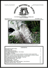
The southern end of the Priory wall. The Pickle is on the left. Photo: David Luff 2013. See page 16
CONTENTS
Programme December–March 2
Ravensbury Walk 3
Visit to Honeywood Museum 5
The Origins of Morden Common – Peter Hopkins 6
Local History Workshops:
13 September: ?crop marks; fireworks in Mitcham; St Lawrence’s church; Sparrowfield 8
25 October: a Bronze Age site; Walter de Merton; C17 land boundaries in Morden; a Hatfeild employee; archaeology in Morden Hall Park; photos from the 1960s 8
Mrs Louisa Boyce at Park Place, Mitcham – Tony Scott 10
The Ruff Memorial Stone – Adrian Gault 11
Up Memory Lane! – Irene Bain 12
Doodlebug Summer – Geoff Cooper 13
Robertson’s Pickle & Sauce Works Ltd (cont.) – Bruce Robertson 14
A Stitch in Time Saves Nine – David Luff 16
PROGRAMME DECEMBER – MARCH
Saturday 7 December at 2.30pm Christ Church Hall, Colliers Wood
‘History of Magic’
An illustrated talk by Michael Symes.
Saturday 18 January 2.30pm Christ Church Hall, Colliers Wood
‘Recent Researches’
Short talks by several MHS members
Saturday 15 February 2.30pm Christ Church Hall, Colliers Wood
‘Thirty Years Caring for the Vestments at Westminster Abbey’
Illustrated talk by Rosemary Turner of the Guild of St Faith
Friday 28 February 12.30 for 1pm Annual Lunch for members and guests
at Taste Restaurant, formerly The Restaurant in the Park. See enclosed booking form.
Saturday 15 March 2.30pm Christ Church Hall, Colliers Wood
‘Worcester Park, Old Malden and North Cheam: History at our Feet’
Illustrated talk by archivist and local historian David Rymill.
Christ Church Hall is next to the church, in Christchurch Road, 250m from Colliers Wood Underground Station. Limited parking at the hall, but plenty in nearby streets or at the Tandem Centre, 200m south. Buses 152, 200 and 470 pass the door.
Visitors are welcome to attend our talks. Entry £2.
An appeal from the editor:
I am sure our readers are enjoying Bruce Robertson’s memories of his family’s pickle business, which are continued in this issue. In the next we begin an account of another Merton manufacturer, long gone. Others, such as Lines Bros toymakers and Young’s dairy equipment works, have figured in the Bulletin before now. Businessess such as these, once so important to the local economy, are a fascinating aspect of local history. We would be delighted to hear from those with personal connections to the industrial past of Merton, who could provide us with more such accounts.
And now the taste test …
Bruce Robertson (see page 14) has made some piccalilli pickles using one of his father’s recipes, and original labels. Jars will be on sale at St Mary’s Christmas fair in the church hall, Church Path, Merton Park on Saturday 7 December 11am to 2pm.
HAVE YOU PAID?
Subscriptions for 2013-14 are now overdue. Please note that this will be the last Bulletin to reach you if we have not received your payment by the time of the next issue.
A membership form was enclosed in the September Bulletin. Current rates are:
Individual member £10
Additional member in same household £3
Student member £1
Overseas member £15
Cheques are payable to Merton Historical Society and should be sent with completed forms to our Membership Secretary.
RAVENSBURY WALK
On Thursday 15 August we explored the east-west rectangle defined by Morden, London and Wandle Roads, taking a route round the outside of a figure ‘8’. This area is home to some interesting survivals, but, alas, rather more ‘sites of’.
We began, at the north gate of Ravensbury Park in Morden Road, with (of course) the site of the early Anglo-Saxon cemetery, emphasising its size (it stretches more than 400 yards eastwards along both sides of the road), the length of time it was in use (at least two centuries, starting about 400 AD) and the fact that the associated settlement has not yet been found. Walking towards Mitcham Station, we pondered the fossil (or palimpsest) route on our left, used by Tramlink (since 2000), the electric railway (from c.1930), the steam railway (from 1860), the horse-drawn plate-way (the Surrey Iron Railway, from 1801) and the field path to Mitcham’s common Westfield (maybe pre-Norman Conquest ?). And wondered if the narrow path that crosses it, leading from pagan cemetery to Christian church, pre-dates the field path ?
Round the corner in London Road we admired the four-storey semi-detached houses built in 1828 by Scottish architect Thomas Finden, surveyor to the Craven Estate (which included Carnaby Street, W1). One of us observed, to acclaim, that the original internal wooden shutters survive behind at least two of the casements. The lovely brick-work in careful Flemish bond of Station Court (c.1800) across the road was duly appreciated, and then we moved south along London Road, passing the sites of the new Fire Station-to-be and the old Mitcham Brewery, and entered Ravensbury Park by its inconspicuous eastern entrance, advertised by neither gate nor notice. We strolled westwards past a fox posing for photographs and over a bridge to look at the splendid cedar tree and ornamental water which are all that remain of Mitcham Grove, whose twenty acres of grounds are now covered by the Watermeads housing estate. There had been a substantial house on this site for some 500 years.
We crossed another bridge, over a narrower channel, probably cut in the sixteenth century to supply the bleaching grounds further west. On our left the Wandle began to widen and deepen into the mill pool, while we tried to identify the splendid mature trees hereabouts, gingko, London plane and holm oak among them. Many were planted in the nineteenth century, but some are still older.
In the centre of the Park, we turned left (ie. south), crossed the bridge over the Wandle into Morden, and left the Park after inspecting probably its oldest plane tree. Turning right into Wandle Road, we passed the site of the last Ravensbury Farm, and noted its surviving and surprisingly large farmworkers cottage on the corner with Morden Road. Pausing briefly at Ravensbury Mill, built c.1800 to grind snuff and tobacco, and sited where there had been a mill for at least 150 years previously, we re-crossed the Wandle (here in two invisible branches under the road) back into Mitcham. Madeline Healey remembers the service road facing us as having previously been yet another small watercourse.
We re-entered the Park by the mill, and, now going eastwards, crossed various confusing bridges. We passed the site of the bailiff’s house on our left, to inspect the mill weir and speculate where exactly all the water wheels were hung. We approved the instructive arrangement of replica mill-stones. On our left, only a length of brick boundary wall now remains to mark the position of Ravensbury Print Works; the works site and the associated bleaching grounds are under the Ravensbury housing estate. The old road from Mitcham to Morden crossed our area here, but it is now difficult to see exactly where, perhaps understandably, as it was diverted as long ago as 1753.
Then we encountered the sad ivy-covered ruins marking the site of the eighteenth-century Ravensbury House, and of its sixteenth-century predecessor. We paused to puzzle over the small brick structure immediately opposite, on the far bank of the Wandle (part of a footbridge ? gazebo ? Victorian boating pool feature ?). We admired the latest feature in the Park (the modern art of the National Cycle Network steel signpost, 2000 AD) and recalled the recent excavation hereabouts of the oldest (a brief Mesolithic occupation by post-glacial hunters, somewhere between 7000 and 5000 BC).
Finally, once more in the centre of the Park, we turned left again, passed the modern children’s playground, and crossed the sixteenth-century cut for the third time, to leave the Park by the north gate where we started, wishing hopefully as we did so that someone would really get down to work and sort out what all these artificial waterways were for, and when they were dug, and give us lots of explanatory maps.
PS. A very rough Summary History of the area
Anglo-Saxon period – no dwellings, probably used for grazing and as water meadow
Medieval period – meadow for hay and a substantial house in north-east corner
– road from Mitcham to Morden established, dividing north-west corner from the remainder
Tudor period – beginning of industry – cloth bleaching to the west of the Morden road;
– mill established on the river
Rebuild of medieval house at Mitcham Grove in brick and stone
C18 – Ravensbury House built centrally as second big house; road moved; ornamental tree planting
C19 first half – cultivation of private estates; poem Ravensbury of idyllic childhood
C19 second half – decline, both big houses and print works demolished
Domestic houses being built along Wandle Road and part of Morden Road
Public pleasure-boating pool established on the Wandle
C20 – advance of domestic housing and establishment of Ravensbury Park
David Haunton
The above reporter was too modest to mention that he led this walk. All who participated expressed their thanks and appreciation to David for a fascinating and informative afternoon.
FOR YOUR BOOKSHELF
MITCHAM HISTORIES 14: UPPER MITCHAM AND WESTERN ROAD.
The final volume in Eric Montague’s epic series includes a Series Index. At 240 pages, it is available at a mere £5.95 (£4.80 to members) at meetings or from our Publications Secretary (plus £1.10 postage)
VISIT TO HONEYOOD MUSEUM
On 7 September a party of MHS members met in the billiard room at Honeywood Museum, in its charming setting beside the western pond at Carshalton. Here Jane Howard, the curator, outlined the history of the building for us. While the front dates mostly from the 19th and early 20th centuries, behind it is a 17th-century flint-and-chalk building, under which a stream flows. Between this building and Pound Street there stood another house, of the same date, that is c.1680, until it was demolished in 1884. Confusingly that building was called Honeywood, while the present Honeywood was called Wandle Cottage, until the name was transferred after 1884.
The first occupiers seem to have been prosperous London tradesmen who probably used the house as a country retreat. During the 19th century there were a number of tenants, some of whom made extensions and improvements to the house. The best known of the Victorian tenants was William Hale White, a civil servant and novelist, who wrote as ‘Mark Rutherford’. He was a friend of John Ruskin, who knew Carshalton, and of artist Arthur Hughes who lived at Wallington.
The house was then transformed by John Pattinson Kirk and his much younger wife Leah, who became tenants in 1878. Kirk was originally a commercial traveller, from Alston in Cumberland, but by 1883 when he bought the freeholds of both houses he was working for Marion & Co of Soho Square. This firm was the largest photographic retailer in Europe, and Kirk became their managing partner.
It was Kirk who demolished the original Honeywood and transferred the name. In about 1898 he replaced an old weatherboarded wing on the north side with a brick one. He was now retired, and a widower, with his adopted daughter Lily, her husband Henry Edwards, their baby son and their servants, all living with him. In 1902-3 he added the billiard room, drawing room, photographic dark room, two more bedrooms and a nursery.
Kirk died in 1913, leaving the house to Lily, who became a professional artist, and she sold it to the council in 1939 for £2000. After wartime use by the ARP Honeywood was hired out for social functions, and used as offices, before being let to a charity. By the late 1980s the council was wanting to establish a heritage centre. Honeywood was their choice for its location, and after extensive repairs the Heritage Centre opened in 1990. Twenty years later the Heritage Lottery Fund, Sutton Council, Sutton Arts Council and the Friends of Honeywood financed a complete refurbishment, and Honeywood reopened in 2012 as a fully accredited museum. It is a Grade II listed building.
The handsome billiard room has a fine table, with hanging lights above; the original scoreboard and cue-rack; as well as leather-covered sofas on shallow platforms, for spectators. Built-in ventilators would have dispersed the cigar smoke (which would otherwise discolour the stained-glass lantern in the roof).
The other rooms, including the large and elegant drawing-room which opens onto the garden, house either permanent displays or temporary exhibitions. So there are rooms devoted to the Wandle, to industry, to wartime, to the growth of the village/suburb, to transport; to childhood, and so on. Reminding the visitor of the age of the core building, a section of the flint-and-chalk chequered wall, which was once on the exterior, can also be seen within.
This was a most interesting afternoon. We are grateful to curator Jane Howard, and to Stephen Wright, who arranged the visit.
Honeywood Museum is open Wed-Fri 11am-5pm; Sat, Sun and Bank Holiday Mon: 10am-5pm. Admission free. There is a shop and a café.
www.sutton.gov.uk/honeywood tel: 020 8770 4297
Judith Goodman
BUILDING ST CUTHBERT’S SHRINE:
DURHAM CATHEDRAL AND THE LIFE OF PRIOR TURGOT
A new book written by our late President, Lionel Green, and completed after his death in 2010 by fellow members of our Society. Set in the period of the Norman Conquest, 1066, this book tells the story of Turgot, a man with a purpose and sense of adventure. Shipwrecked returning from Norway, he becomes part of the community in Durham, and embarks on the ambitious project of building a shrine worthy of the legends and legacy of St Cuthbert.
The author Lionel Green had been researching for this work for a number of years, since publishing his earlier book A Priory Revealed using material related to Merton Priory. It is available on Amazon:
http://www.amazon.co.uk/Lionel-Green/e/B0034NDN3G/ref=ntt_athr_dp_pel_pop_1
We have been asked to inform members of a new novel, available only as a Kindle e-book:
THE HAMILTON BITCH by Vanda Cain
‘Emma Hamilton was a legend in her own lifetime. The doyenne of reinvention, she escaped from poverty on the Wirral Peninsular to become the mistress of aristocrats and via the fleshpots of London, emerged from her most famous metamorphosis as the wife of Sir William Hamilton, ambassador to the Court of Naples. The most beautiful – and most frequently painted – woman in Europe, was a singer, dancer, mime artist, linguist and accomplished ambassadress. When she flung away her newfound respectability to live in a triad with Hamilton and her famous lover, Horatio Nelson, it was the scandal of the age.’
http://www.amazon.co.uk/The-Hamilton-Bitch-Vanda-Cain-ebook/dp/B00F0MKICI
Photo: Judith Goodman 2013
PETER HOPKINS ponders
THE ORIGINS OF MORDEN COMMON
I have been familiar with the 1553 ‘plotts’ or plans of Sparrowfeld Common for many years, since fellow-member John Pile gave me a copy of his tracings (right). The triangular section in the centre right of the plan was disputed between the tenants of Morden and their neighbours in Cheam. In due course this became Morden Common, and the adjoining section became Cheam Common. The tenants of all the surrounding villages and manors had shared this large expanse of open pasture for centuries, and I had always assumed that the frequent disputes, recorded from the 14th century onwards, reflect the inevitable conflicts of interest as population and livestock increased and tried to exercise their ancient rights in a finite area of land.
But recently John Pile and David Rymill, the historian of Worcester Park who will be our speaker in March, have been copying me into their email discussions about the boundaries of the two manors of Cheam (Worcester Park being partly within the ancient parish of Cheam).
The second – and officially accepted – plott of 1553 (above) shows a boundary line between the manors of Upper and Nether Cheam, and John Pile has plotted this onto the outline of 19th-century Ordnance Survey maps (opposite). Although the portion of Sparrowfeld allocated to Upper Cheam is larger than that allocated to Nether Cheam, the two sections are comparable in shape. However, the section claimed for Morden Common occupies more than half of Nether Cheam’s share! Could Cheam’s claim to Morden Common have been justified?
Of course, boundary lines within open land shown on a mid-16th-century map may not reflect an ancient situation. But the map also shows a more substantial boundary – a ‘banke’ marked along the western edge of the Pyl Brook. Surely this wasn’t created merely to stop animals falling into the brook! But why would Morden tenants create a bank to mark a boundary between their arable and common pasture – a boundary already marked by the brook itself? Isn’t it more likely that this had been created as a boundary between Morden and Nether Cheam?
Is it possible that Morden once had an area of common pasture on the east bank of the brook? Between the Pyl Brook and Lower Morden Lane lay the medieval open field known as the Southfield. But a glance at the 19th-century OS maps reveals that the Southfield adjoined Sutton Common on its eastern edge, and the northern boundary of Sutton Common in the early 19th century was a continuation of the line of Lower Morden Lane. The 1553 plott shows an ancient enclosure in the southern corner of the Southfield by Pylford Bridge, very similar to the ancient enclosures shown on the plott along the ‘London Waye’ within Cheam. It does not seem beyond the bounds of possibility that the Southfield had been converted from common pasture to arable later than the ancient enclosures along the London-Epsom Road. The arable land north of Lower Morden Lane was known for centuries as Old Mordens, suggesting that it predated the arable land within the Southfield.
Can we date the creation of the Southfield? I have been arguing for some months that the Lower Morden settlement was post-Conquest, as there were only 8 villeins recorded in Domesday Book, whereas there were 17 customary virgates listed in the Custumal c.1225. I have previously suggested that the 8 Domesday villein tenements were between the site of St Lawrence’s church and Lower Morden Lane, where 8 crofts were recorded in later medieval records.
Presumably the 8 Domesday villeins each held a typical virgate holding. The 5 cottars also recorded in Domesday probably held around 4 acres each – again a typical cottar holding – and I have suggested before that these 20 acres were to form another virgate holding – probably the one known to have been in Central Road until the late 13th century – the Morden customary virgate is known to have been of 20 acres. But these two groups of Domesday holdings would only account for 9 virgates. Where did the land come from to provide another 8 virgates by 1225? The Southfield totalled some 175 acres, excluding the crofts and tofts of the settlement south of Lower Morden Lane. When one allows for the allocation of some former arable land north of Lower Morden Lane for further crofts and tofts, we see that sufficient additional arable land for the new virgate holdings could have been obtained by converting former common pasture east of the Pyl Brook into the open field that became known as the Southfield.
In the late 11th or early 12th centuries there was little pressure on common pasture. It wasn’t until the late 13th century that population growth reached the stage where there was a shortage of land. Westminster abbey and its farmers could well have decided that there was sufficient common pasture within the area of Sparrowfeld west of the Pyl Brook, and that former common pasture on the east bank could be converted to arable. At that period it was unlikely that the neighbouring communities would have objected – with so much pasture available to them they probably didn’t make use of the pasture on the opposite bank of the brook. It wasn’t until later that conflict arose.
One final comment – when plans were first being mooted to enclose Merton Common in 1806, parishioners of Morden were entitled to object. Among the documents that used to be in the parish chest at St Lawrence were notices sent to the Morden vestry, together with their response – a petition against enclosure, claiming that ‘the Majority of the Cottagers have large Families and will be wholly deprived of firing which at present they enjoy from the Common. That it is not in their power to purchase Coals or other fuel and will drive them to the greatest Distress – We therefore pray those whom it may Concern that the Common may remain in an open State as it now is – subject only to such Stint or other Improvement as the Inhabitants in Vestry shall approve and direct’. It seems strange that parishioners of Morden could object to the enclosure of Merton Common, but they had certain rights as the common extended as far as the parish boundary. The 18th-century writer Richard Gough, in his The History of Myddle, describes a similar claim to common ‘by reason of vicinage [or proximity], but all that they ought to claime is onely liberty to turne out theire catle att theire owne gates, upon a litle of theire owne land which they have left out beefore theire gates, and soe they streake out further; but they cannott staffe, drive, nor incloase, nor hinder incloaseing’. It would appear that neighbours had limited rights over adjacent common land, and it is possible that Morden’s original claims within trans-Pyl Brook Sparrowfeld was of a similar origin but that later generations managed to procure full common rights. Merton Common was eventually enclosed by Act of Parliament in 1816. All rights in Morden Common had come into the hands of the Garth lords of the manor, so they were able to enclose it without recourse to Parliament, though some sections are still recognisable in the 1910 Valuation of Morden, recently published by the Society.
Note: North is to the right!
MERTON
MORDEN
Old Mordens
Pyl Brook
LOCAL HISTORY WORKSHOPS
Friday 13 September 2013 – 4 present – Peter Hopkins in the chair
. David Haunton had been asked by Clive Whichelow to look at possible crop marks in Dundonald Recreatiom Ground, and two had been found. On the bowling green (A) represents modern drainage. Apart from its regularity, the clue is that the pairs of branches do not meet the main stem at the same point, but the joins are staggered. This is because the stem is composed of a line of straight drainpipes, interrupted by pairs of pipes, each with a single branch – here laid first one to the right, then one to the left.
Roughly in the centre of the Recreation Ground (B) was a faint brown parch mark, which soon became green after a couple of rainy days. This is a squat rectangular outline, more than a foot thick, extending 17 ft. east-west and 20 ft. north-south, with a square blob, twice the thickness of the outline, in the centre of the western line. There is a straight line, not connected to the rectangle, extending some 30 ft. eastwards. (All measurements are very approximate.) At present what this represents is unknown – it might be a building connected to activities on Merton Hall Farm (whose land lay here). Clive is going to inspect old maps of the area for clues, but any ideas would be welcome.
. Rosemary Turner’s eye has been caught by mention of the Mitcham fireworks factory in the 1910 valuation. Trying to find out something of the workers – where did they come from, why, and did they follow the factory move ? – she has found to be full of challenges, not helped by the different and non-overlapping questions one may ask of the 1901 and 1911 online censuses.
. Madeline Healey corrected a point in the September Bulletin: she has found that the gold watch owned by her grandfather was not presented to him as captain of the belfry, but was an inherited heirloom. She has a facsimile of the 1907 Army and Navy Stores catalogue, which includes the story of its origin as a Co-operative Society; no local perfume firms are mentioned, but a small firm is offering ‘Mitcham Lavender’ scent.
. Peter Hopkins had some points relating to St Lawrence’s Church. (1) The ‘three-decker’ pulpit mentioned during his walk comprised pulpit above, with lectern rather lower, and clerk’s desk lowest of all; the lectern was cut back in 1905. (2) The parish had supplied him with a copy of an advert offering prints for sale, including one of the church by artist Mildred Summers (of whom nothing is known) and (3) had asked permission to print Peter’s leaflet on St Lawrence’s Church for Open House.
Peter’s main discussion was about the great common of Sparrowfield, used by several medieval manors. He suggests that Cheam’s frequent complaints of incursion by Morden tenants on ‘their’ bit of Sparrowfield were justified, due to new villeins having been settled on the ‘Morden’ bit of Sparrowfield, converting it to arable, and requiring Morden tenants to look further afield for their common land. (See p.6)
David Haunton
(A)
(B)
Cropmarks in Dundonald Recreatiom Ground North is towards the top in both
Friday 25 October 2013 – five present – David Haunton in the chair
. Peter Hopkins had received an enquiry regarding Corporal L D Hawkins who was in the Home Guard at the Mitcham Creameries, though he was not there at the time of the explosion. A memoir had been written by a friend, who asked us to supply him with photographs. He has sent a copy of his draft and is looking for someone to publish it. It is very well written, but Peter thinks it more suitable for a military publisher. Dave will read it. The title is Hidden in Plain View.
Peter had received a book order from someone in Waltham Abbey who is interested in textile printer Littler. They had also seen the 1838 survey by Crawter & Smith and wondered if we knew of these two web-links relating to Crawter: www.aim25.ac.uk/cgi-bin/vcdf/detail?coll_id=13352&inst_id=118 and www.nationalarchives.gov.uk/A2A/records.aspx?cat=046-decr&cid=0#0. Would someone like to follow this up?
The latest Surrey Archaeological Collections mentions the archaeological report for the Sun Alliance sports field in Raynes Park. Evidence of ancient wood clearance has been found, and it is suggested that there was a Bronze Age settlement in the vicinity.
After the visit to Morden parish church two ladies asked Peter if they could see the hatchments. They have sent us copies of their photographs. Bill Rudd has written a detailed description of them in the past, and Peter wondered if the two could be united in a publication.
In the latest Surrey Record Society publication Royal Justice in Surrey 1258-1269 there is an entry that says Walter de Merton had oxen at his manor at Malden and treasure at Merton taken by Simon de Montfort’s supporters. Peter was surprised to learn that Walter, who was deposed as Chancellor by de Montfort, would have possessions at Merton.
When researching for the visit to the church he had discovered that the tithes had been restored c.1630 by letters patent of Charles I. Peter has obtained a copy, which states that Richard Garth gave new glebe land in exchange for the former glebe. The boundaries of the land given by Garth are given, helping to fill in gaps in Peter’s medieval research.
. Cyril Maidment brought along copies of David Luff’s photographs of Merton priory wall. He was querying the location of one of them.
He is busy working on the Wimbledon Society’s exhibition for the 900th anniversary of the priory.
. Madeline Healey’s cousin in Ireland has been looking into their ancestor Abraham Clark, who left the local employ of the Hatfeilds and went to work at Westcliff-on-Sea, where he is thought to have worked on land owned by members of the Hatfeild family.
Madeline also explained the background to the photo on page 5 of Bulletin 187. She had seen advertised an open event at the bell tower of Mitcham parish church, where her great-grandfather had been captain of the bell ringers. There was an option to have a go at ringing, and to ascend the bell tower. Madeline attempted both, and got part way up the ladder. She took a couple of photos, and someone else took more for her.
At an earlier workshop there had been an enquiry about what Smith Meters had done during the war. Madeline had met a lady who had worked there and said that they made timing detonators for explosives.
. David Haunton reported that the recent London Archaeologist ‘Fieldwork Roundup’ mentioned Dave Saxby’s watching brief in Morden Hall Park, near the new turbine. They discovered a Saxo/Norman period east/west truncated water channel. Over it was a mid-18th-century wall of a snuff mill made of reused softwood planks, with small internal walls. Madeline said that before building the café and shop they found dried-up riverbeds. Dave Haunton said that a number of such braided channels have been found in the area which would have contained water at different dates.
Peter Brunton had sent him photos of Mitcham Carnival 1964-6, and of the Figges Marsh flowerbed depicting various coats of arms. Rosemary had heard that a while back they were thinking of reinstating this.
Dave mentioned the book he was working on with the John Innes Society – Merton Park 1931-1950. He had made a list of topics to cover, and asked those present for comments and suggestions.
Rosemary Turner
Dates of next Workshops: Fridays 13 December, 31 January and 14 March at 2.30pm
At Wandle Industrial Museum. All are welcome.
Mitcham Carnival 1966 ‘World Cup for Women’
Dr TONY SCOTT tells the story of a melancholy resident of Mitcham:
MRS LOUISA BOYCE AT PARK PLACE, MITCHAM
I had an enquiry recently from a lady in Edinburgh anxious for information about a relative of hers, a Mrs Louisa Boyce, who lived at Park Place, Mitcham, in the mid-19th century. Mrs Boyce’s story is probably deserving of a wider audience, and my reply, slightly expanded, is given here. Much of the information may be found in Eric Montague’s Mitcham Histories: 11 The Cranmers, The Canons and Park Place published by this Society in 2011.
Mrs Louisa Boyce took on the lease of the house called Park Place, off Commonside West, in Mitcham in about 1850. She is described in the 1851 census as a widow of 28, a gentlewoman and fund-holder, with a baby girl aged two. The staff at the house included a housekeeper, two lady’s maids, a cook, a housemaid, a kitchenmaid, a nurserymaid, a footman and a coachman. There is however rather more to Louisa Boyce’s background than the simple census details reveal.
Louisa was born Louisa Georgina Murray in 1822, daughter of Sir George Murray, Master of the Horse to King George IV, and Lady Louisa Murray, formerly Lady Louisa Erskine. Sir George Murray had a distinguished career in the army during the Napoleonic Wars, and held the office of Secretary of State for the Colonies in the Duke of Wellington’s administration 1828-1830. The Duke was godfather to Louisa.
This enchanting portrait of ‘Miss Murray’ by Sir Thomas Lawrence PRA hangs on the wall at Kenwood.
In her early twenties Louisa married her father’s ADC, Captain Henry Boyce of the 2nd Life Guards, and in 1849 a daughter, also called Louisa, was born. Sadly, at about that time Captain Boyce died, after only a few years of marriage. Being a widow with a young baby must have been devastating for Louisa, and she withdrew into deepest mourning. For several years after her arrival in Mitcham in 1850 she appeared rarely in public and was then always wearing a thick veil of black crêpe. For ten years or so she seems to have taken little or no part in the life of the village, and apparently had few guests, though brother-in-law Commander Frederick A Boyce is recorded as a visitor in the 1851 census.
In 1862, when Mitcham seems to have experienced something of a religious revival inspired by the new vicar Daniel Wilson, Louisa Boyce emerged from her seclusion and became actively involved in evangelical work. On Whitsunday 8 June 1862 she started a Bible class in a cottage in Merton Lane (now Western Road), opposite its junction with Love Lane and about ten minutes walk from Park Place. Six months later, the class was moved to the, for her, more conveniently located lodge at Park Place.
Louisa now took a more active part in other aspects of the life of the parish, and is mentioned in the pastoral letters of Revd Daniel Wilson as being a member of the Ladies Visiting Society. A few records of the visits made by members of the Society still exist. The group concerned itself with visiting individuals and families and trying to relieve poverty and distress among the village labourers, those unemployed, and also the aged and infirm. Contacts were made to try to find work for a young person supporting an infirm parent. Frequently Bibles would be left at the house.
Louisa left Park Place and Mitcham in 1873, and the Bible class was taken on by Mrs Mary Chart, wife of John Chart, a local shopkeeper and undertaker. The venue was moved to the mission hall in Clarendon Grove, behind John Chart’s premises and close to the Three Kings Pond.
Louisa’s relative who made the enquiry told me that Louisa became friends with a Revd Graves and his wife, possibly after she left Mitcham (I can find no reference to a Revd Graves in Mitcham), and in 1882 the three of them went to live in Bordighera in Italy. Now a holiday resort on the Italian Riviera, Bordighera was probably still a small fishing village then. Here Louisa Boyce had a villa, a school and a church built, and spent her time converting the Italians to Protestantism. She died in 1891 and is buried there.
It would appear that young Louisa did not follow her mother to Italy. She was recorded as resident at Park Place, aged 22, in the 1871 census, but by 1881 she had moved to the Kingston census district, and after that cannot be easily found. Did she then move to Italy, did she marry, when did she die? It remains a mystery.
Louisa was the leaseholder, not the owner, of Park Place. The original house was probably medieval, and was either rebuilt or substantially modified and extended in the 1770s. It is asymmetric, which suggests a large extension at one time. In 1815 Park Place was bought by Esther Maria Cranmer, lord of the manor of Mitcham Canons, and when Louisa moved in the owner was William Simpson, lord of the manor and son-in-law of Mrs Cranmer. He died in 1860 and Park Place was inherited by his son, also William.
Park Place still stands, although the lodge was demolished in 1969. After various owners and uses it is now a Toby pub and carvery restaurant.
reproduced courtesy of English Heritage
ADRIAN GAULT celebrates
THE RUFF MEMORIAL STONE – 50-YEAR ANNIVERSARY
In the west corner of Mitcham Cricket Green stands the Ruff Memorial Stone. This was erected 50 years ago in honour of Tom Ruff, who was Mayor of Mitcham at the time of his death in 1962. Tom had been a stalwart of Mitcham cricket club for many years, including captain of its Wednesday XI. The Stone was paid for by voluntary contributions from across the Borough and unveiled at a public ceremony in 1963.
The stone also records the names of 16 Mitcham cricketers, who apart from a connection to Mitcham have made an outstanding contribution to the game.
Mitcham’s place within the game is, of course, unique. The Green has seen cricket played on it for hundreds of years. So far as we can tell, the Green has the longest record of continuous play of any ground in the world.
Many famous players have played on the Green over the years. Most of the 16 recorded on the Ruff Stone went on to play for Surrey, and many represented England sides of one kind or another. The oldest was John Bowyer, born 1790 who – when playing on the Green as a boy – was given five shillings by Nelson to ‘drink confusion to the French’. He went on to umpire on the Green up to the age of 80. The most recent is Burn Bullock, after whom the listed pub on the corner of London Road and the Cricket Green is now named.
The other 14 are Daniel Hayward, Charles Hoare, Tom Sherman, James Southerton, Tom Sewell, Tom Humphrey, Richard Humphrey, W W Thompson, Thomas Harvey, Tom Richardson, F C Holland, Herbert Strudwick, Ernest Bale, and Andy Sandham.
To mark the 50-year anniversary, Mitcham Cricket Club have issued a 36-page book with lives of the 16 players, and a photo of each. This is available for £4.95 (including postage, cheques payable to Mitcham Cricket Club) from the Secretary, 4 Salisbury Avenue, Sutton SM1 2DQ.
It It will tell you much more than we can do justice in this short article, including: which of the 16 was buried with his bat; who was living at the time of the 1861 census in the cricket pavilion at Kensington; who used to bat with his eyes closed; who scored 325 for England against the West Indies; who began his cricket at Mitcham and became one of the greatest fast bowlers of all time.
James Southerton
Tom Richardson
IRENE BAIN revisits a fondly remembered scene:
UP MEMORY LANE!
On Tuesday 8 May 2012 I went up, but not down, Memory Lane. My kind daughter-in-law took my sister and myself where we had been longing to go, and had not been able to for about 50 years.
When I was a child and lived in New Barns Avenue, Mitcham, they were building new houses at the top of our road. I could hop and jump over the marked-out plots, as children could roam in those days. From there you could see all the way up to Pollards Hill.
There were fields at the bottom of the hill, and it was well named, because there were a great many oak trees there, which would have been pollarded. The oak-leaf was a symbol of the area and of our school. My brother watched them felling the oak trees when he played truant from school one afternoon! Every child would have recognised the shape of an oak-leaf. We used to play in the fields, which were easy to get to, because the area was still countrified before all the new houses and the shops were built.
A favourite Sunday afternoon walk with my parents would be going up Pollards Hill. Beside the well-worn path were briar roses growing in the hedge. There was also a huge golf course in this area, eventually covered by the Pollards Hill housing estate. The tower blocks were built many years later, after the war.
When you got near the top of the hill, still standing there was part of an old farm building, and a big milk churn was left by it for many years.
It was well worth the effort of climbing the steep path which led upwards after the turning by the old milk churn. We children would play up there, and run up and down the slopes. You found yourself on top of your known world, with breathtaking views all round. It was exhilarating. There is a huge indent in the middle at the top of the hill. There was a marble fountain for us to have a drink if we wanted one. There were toilets at the bottom of the park area, constructed with lots of flint in the walls, which were strange and rather spooky.
The indent at the very top of the hill made you think of ancient times, for surely the people in far-off days would have inhabited such a high vantage spot.
My sister and I, now in our respective seventies and eighties, used often to talk about Pollards Hill and how lovely it was to be there so high up in the world, and how we would love to see it again, just one more time. Well, that happened.
It was a cloudy, slightly rainy sort of day. My daughter-in-law took us up in the car, the back way, for the gradient is so steep. The grass smelled just as we remembered, and was as green. There were a lot of wild flowers. The years rolled away as we remembered how we could set off from home to play up there, my brother and I, and my sister many years later on, on her own (there being an 11-year gap between us), as was possible then.
The hill was used as a vantage spot when the Crystal Palace burnt down, and my parents, along with many other people, went up there that night to see the blaze, as you could see for miles from there.
The toilets had gone – which was just as well in this age. The viewpoint giving information for all the major compass points all around had gone. The marble water fountain was still there, but not functioning now. Some of the area had been fenced off, maybe to help wildlife, for there is not a lot of space to hide in.
We stood for a long time looking at the view from all angles, and breathing the lovely fresh air, and smelling the grass. Then we went back down towards home, feeling very very pleased to have seen it just one more time.
[While the residential area known as Pollards Hill lies within the borough of Merton, the Hill itself is just over the borough boundary in Croydon. It can be reached from London Road, Norbury. JG]
Photo: Judith Goodman 2013
GEOFF COOPER recalls
DOODLEBUG SUMMER
The welcome message arrived about three o’clock that Friday afternoon. Having been incarcerated in the air raid shelters at Rutlish School for some five hours, we were delighted to be told that we could leave and not return till Monday. No Saturday school! As Maurice and I cycled home, we decided to make the best of this unexpected holiday by going to Lord’s, where a match between the Army and the Royal Australian Air Force was due to be held.
The previous evening, after a game of tennis in Mostyn Gardens, I had made preparations for an early start in the morning, as the school swimming session at the Wimbledon Baths would begin at seven o’clock. I had not been in bed long however when the air raid warnings sounded. By now, as the all-night raids of the Blitz had become a distant memory, no longer did the sirens’ wailing send us to the Anderson shelter at the foot of the garden. Instead, from the comfort of our beds, we would listen to the desultory action, the brief anti-aircraft barrage greeting the passing bomber, whilst anticipating the steady note of the ‘all clear’ bidding us to sleep peacefully.
But that night, 15 June 1944, proved to be quite different. The sound of the aircraft had altered, there were more of them, and the anti-aircraft guns remained active. In fact their apparent success heartened my sister and me as we watched from a bedroom window in our house in Hillcross Avenue, Morden. ‘Look’, she exclaimed excitedly, ‘There’s another one down. We must have a new secret weapon!’
Although she correctly perceived a new and secret weapon, she was mistaken when ascribing its ownership. Far from watching the destruction of enemy aircraft, we were in fact witnessing the arrival of the first flying bombs in the area. Initially described in the press as p-planes (pilotless planes), they soon became known as doodlebugs.
In spite of the disturbed night, the swimming session was well attended in the morning, and after breakfast (sandwiches eaten in the yard) morning assembly started just another school day. Hardly had the first lesson begun, however, when the air raid sirens set in motion an unforgettable sequence of events. As we bade one another farewell upon our release from the shelters later, we had no idea that months would pass before we would all be together again. In the meantime we would be dispersed to various parts of the country, and never again would any of us enter either the Junior Building or the Science Block, both destined to be destroyed in the onslaught on London which had just begun. Moreover, once we had returned, several years would pass before the whole school could operate on one site.
The cricket match, already under way when Maurice and I arrived at Lord’s, proved to be disappointing, as indicated by a Sunday press account. Under the heading of ‘Batsman Stumps and Stumper Crash’ it began, ‘The RAAF XI made a spirited recovery after a disastrous start at Lord’s yesterday, and finished by beating the Army, who gave a dismal batting display, by 77 runs’. There followed an analysis of the play, emphasising the incident referred to in the headline. But this was not the most memorable feature at all. What remained most firmly fixed in one’s mind was not mentioned – and that was the stoppages caused by doodlebugs. Fortunately, none fell near the ground that day.
The game ended early, and Maurice and I decided to round off the holiday by going fishing. Thus engaged, early in the evening on Cannon Hill Common, our idyll was disturbed by the ever-increasing sound of an approaching doodlebug. Looking up, we stood rooted to the spot as we watched the bomb, above Cherrywood Lane, and heading straight for us. The engine cut out. The bomb swerved sharply off course and plunged onto houses on Northway. A pillar of smoke and dust silently rose into the air. Shaken by this close encounter with danger, we hastily gathered up our belongings and cycled to our homes.
That night was spent with my family sitting under the stairs, while bombs continued to pass overhead. The following morning the Anderson shelter received a quick spring clean and, once again, became our nightly refuge.
School did not re-open that academic year, except for those unfortunate enough to be public examination candidates, who, I believe, sat the papers in the air raid shelters. By then I was 100 miles away, one of the 70 Rutlish boys evacuated to the Derbyshire mining village of Heanor on 8 July.* Some stayed there till Christmas, but I returned on 17 October, just in time for the annual Commemoration Service at St Mary’s church on Trafalgar Day, to find that the dance hall in the Old Rutlishians’ clubhouse was now my form room.
* An account that I wrote about the happy time we had living among those kind and friendly people was published in the Derbyshire Life and Countryside magazine in October 1999.
The heading of the match score card
BRUCE ROBERTSON continues his account of
ROBERTSON’S PICKLE AND SAUCE WORKS LTD
Part 2
Other products
These included items such as ‘Chinese Ginger’, ‘choice young stem in heavy syrup’ attractively packed in exotic faceted jars; ‘Horseradish’, which the label stated contained English-grown horseradish plus turnip, flour, sugar, salt, acetic acid solution, tragacanth, saccharin, salad cream, edible oil and egg yolk (as a child I found this too hot, but as I grew older I wouldn’t consider eating roast beef without it); groundnut ‘Cooking Oil’, which the label stated was ‘Refined & deodorised pure vegetable oil for all cooking & frying, salads and mayonnaise’; ‘Salad Dressing’, which was made up of malt vinegar, soya flour, sugar, salt, wheat flour, oat flour, gum tragon, mustard, saccharin, flavouring and colouring. The label also stated ‘This product is not a salad cream or mayonnaise and does not comply with the statutory standard prescribed for these products’. Whatever it was, as a kid I liked it on my salads, as it gave them some taste. My favourite products were the concentrated orange, grapefruit and lemon squashes and lime juice cordial, which the label instructed had to be ‘diluted to taste’. Lemon barley was introduced later. All these came in 26oz bottles or gallon jars.
Raw Materials
Vinegars. Vinegars would be delivered in large barrels of 36 to 40 gallons capacity from either the Derby Malt Vinegar Company or the Penistone Malt Vinegar Company. An articulated lorry with a flat-bed trailer would turn up, loaded with barrels on their ends, and reverse into the main yard. A typical load was 36 barrels. A barrel ‘skid’, which looked like a long wooden ladder, but with metal rungs connecting the angle-shaped sides, would be attached to the back of the trailer, with its base extending out behind down to the concrete floor. Each barrel was pulled over at a slight angle and rolled on its bottom edge to the top of the skid, where it was then lowered lengthways onto the skid. Another man, on the ground then took over, and pulled the barrel down the skid to the concrete floor, where it would land on a hessian sack stuffed with old sacks to act as a cushion. The barrel was then turned sideways and pushed or steered by kicking one end or the other, to the end of the yard. The first ones sometimes crashed against the factory wall, and then acted as buffers for the rest.
Vegetables. Looking through the papers my father kept after closing the factory in 1969, I came across invoices from William Graham & Co (London) Ltd for vegetables supplied between October and December 1968. They included:
9 October 1968 – 1 ton English Fresh Baby Beetroots 1968 crop size ¾ – 1¾ inches @ £28.0.0. per ton
31 October 1968 – Two plastic barrels each containing 105 kilos net Dutch Sound & Crisp Silverskin Onions in Brine 1968 crop size ‘1B’ (20-22mm) Pure Whites @ £25.12.0 (£25.60) per barrel Duty Paid ex. Quay Boston (Lincs.) ex. S.S. ‘ISOLA’.
14 November 1968 – ½ Ton English Large Best Red Cabbage 1968 crop @ £21.0.0 per ton. Delivered Mitcham.
14 November 1968 – 50 half bags Dutch Wybo No.1 Unpeeled Pickling Onions 1968 crop @ 23/- (£1.15) per half bag ex. S.S. ‘FOKKE DE JONGE’ at Boston.
10 December 1968 – 1 cask containing 150 kilos net Italian crooked 50/300’s gherkins in brine 1968 crop @ 23 shillings per cask. Duty Paid delivered Mitcham ex. S.S. ‘IVAN MAZURANIC’ at London (Docks).
Mint Sauce. I was surprised to find invoices from Horlicks Ltd, by appointment Purveyors of Malted Milk to the late King George VI. Evidently they also supplied mint sauce. An invoice dated 11 February 1969 was for 120 cases of Robertson’s Mint Sauce (12 bottles per case). The cost was 7/- (35p) per case, giving a total of £42.0.0 minus 17/6d (87½p) credit for a mint label allowance per gross – the final total being £41.2.6 (£41.12½p). I confess it took me a while to work that total out, even though it was straightforward, whereas my father would have done it in seconds. I’m glad I didn’t become a Post Office auditor in my early career with Royal Mail until shortly after decimalisation was introduced on 15 February 1971. I would never have coped.
Fruit Squashes. These came in the form of essences from Bush, Boake, Allen Ltd, London N1. Among the papers was a recipe book for most of the products. Should you want to produce 40 gallons or 240 bottles of orange squash, for instance, you would require:
130lbs – Sugar
5 gallons – Orange (Concentrate)
4oz – Two in Ten Essence Orange
2½oz – Preserve
50oz – Citric acid (at a ratio of 5lbs citric acid to 1 gallon water)
1 Quart & 10 oz – Water
Sauces
These were produced in the kitchen, which, from memory, had on the left-hand wall a doorway through to the storage room, where many ingredients were kept e.g. slabs of dates, dried fruit, flour, starch, sugar, salt, apple pulp and onion skins. Next to that doorway was a preparation table. Against the back and right-hand walls aluminium steam-jacketed and heated pans, four in total, were fitted. Above them was a stainless steel trough, about a foot wide and four inches deep, attached to the wall on brackets. It started high on the left-hand side of the back wall and descended gradually to low on the right-hand wall, where it emptied into a shoot with a removable stop-end. A large stainless steel tub on a four-wheeled trolley would be placed under the shoot. Prepared ingredients would be cooked for about an hour in a pan (or pans), flour and starch added to thicken, and acid poured in when boiling. When the sauce was ready, stainless steel buckets would be used to transfer it into the trough, where it would flow down to the shoot and be emptied into the tub on the trolley. Presumably the time taken allowed it to cool sufficiently before transfer to the bottling room. A distinct memory is helping the cook to wheel a trolley loaded with a tub of mustard pickle sauce. She was pulling it backwards and I was pushing it from the rear, when one of the trolley’s wheels went down a gully – and the tub tipped over. The poor woman was hit by a 40-gallon wave of very warm yellow mustard sauce which seemed to cover her from the neck downwards. After her initial scream of shock she stood in a yellow pool with her arms held up dripping more yellow into the pool, looking down at herself in bemusement, not sure whether to laugh or cry. Fortunately her apron and overalls saved most of her clothes from being ruined. I like to think that I gallantly ran to her aid, but suspect I collapsed in laughter at the sight she presented.
Here are two recipes copied from my father’s notes to try!
Sportsman (Brown) Sauce Worcester Sauce
Sugar (30lb) Dates (6lb)
Salt (10lb) Malt Vinegar (14 gallons)
Dates (21lb or 1 slab) Condiment (14 gallons)
Dried Fruit (6lb) Salt (10lb)
Apple Pulp (½ bucket) Onion Skins (20lb)
Flour (15lb) Apple Pulp (10lb)
Starch (8lb) Sugar (30lb)
Tomato Red (1 spoon) Ginger (1lb)
Ginger (1lb) Chillies (2lb)
Pepper (½ lb) Cayenne (1½ lb)
Cloves (½ lb) Pepper (1lb)
Cinnamon (½ lb) Cinnamon (½ lb)
Cayenne (1¼ lb) Cloves (½ lb)
Acid (1½ gallons) Nutmeg (½ lb)
Preserve (6oz) Kippers (4lb)
Caramel (½ bowl approximately) Acid (1¾ gallons)
Onion Skins (10lb) Lemon (2oz)
To be continued
DAVID LUFF reflects that
A STITCH IN TIME SAVES NINE
A well-known saying, something we all recognise. We have purchased, been given or otherwise acquired an item, and we want it to stay in good condition for the future. Should a repair be needed we do it as soon as possible. This way we minimise cost.
So how does this apply to the Priory wall? The answer is very easy, as exactly the same principles apply.
Merton Historical Trust had the responsibility of looking after the interests of our historic buildings until replaced by Merton Priory Trust in 2003. Neither has ever filled me with confidence. Especially when they allow a Grade II listed building – the Colour House – to be surrounded by market traders’ stalls and hoardings. Also its walls have a number of plaques affixed, including one signposting the Ladies and Gents. What chance then has the Priory wall?
The developers of SavaCentre and the ‘relief road’ did take special care when working close to the Priory wall. A small section of wall has been underpinned, most likely to prevent it from collapsing.
Trees were planted on the western side and on a cycle/footpath on the eastern side, running alongside the Pickle. Unfortunately, over the past 20 years the trees have been allowed to grow unchecked, and now the great impregnable forest of Merton has engulfed the Priory wall and the footpath. Yet a Sainsbury’s signpost still proclaims a ‘right of way’.
Gone are the days of willing volunteers and sponsored skips, and, as you can see from the photo on page 1, the Priory wall could certainly have done with a stitch in time.
Letters and contributions for the Bulletin should be sent to the Hon. Editor.
The views expressed in this Bulletin are those of the contributors concerned and not necessarily those of the Society or its Officers.
website: www.mertonhistoricalsociety.org.uk email: mhs@mertonhistoricalsociety.org.uk
Printed by Peter Hopkins