 MERTON HISTORICAL SOCIETY
 Bulletin 211
Download Bulletin 211
June 2019 – Bulletin 210
Windsor Floors (the continuing story) – Mick Taylor
My Life in Mitcham 1939–1966 part 2 – Michael Pollock
Curving Boundaries in Morden and Merton – Peter Hopkins
Bushey Road Camp – David Haunton
and much more
VICE PRESIDENT: Judith Goodman
CHaIR: Keith Penny
BULLETIN No. 211 SEPTEMBER 2019
See p.5 Photo © Real Photographs Co.
CONTENTS
Programme September 2019-February 2020 2
Local History Workshops:
10 May 2019: Errors avoided; R G Jones; Homes fit for Heroes; W Rock & Son; Nazi medal
3
21 June 2019: Mitcham Home Guard; a rail recovery; the Wandle in two modern poems;
Dewey Bates; a Navy stoker; garden crop mark; Mornington Crescent; silks from cigarette packets
5
Windsor Floors (the continuing story) – Mick Taylor
7
‘The Villages of Sutton’ 8
Visit to Merton Priory Chapter House 9
Curving Boundaries in Morden and Merton – Peter Hopkins
10
Help Wanted – Bushey Road Camp – David Haunton
12
Merton Heritage Discovery Day 13
My Life in Mitcham – 1939 to 1966 (Part 2) – Michael Pollock
14
For Your Bookshelf – The Glass Bulldog; A History of Cranleigh Lawn Tennis and Social Club 1929-2019 16
Subscriptions 16
PROGRaMME SEPTEMBER 2019 – FEBRUaRY 2020
Thursday 12 September 11am
Visit to Post Office Museum
Our group must pre-book at £13.50 each, including the Mail Rail ride, with no refunds.
Please pay Bea when you book with her
Meet at the museum at Phoenix Place, London WC1X 0DA.
Travel via Northern Line to Farringdon; or Piccadilly line to Russell Square
or Chancery Lane; or Kings Cross on Thameslink and Northern line.
Saturday 12 October 2.30pm St James’ Church Hall, Merton
‘Secret Rivers’
An illustrated talk by art historian Thomas ardill, of the Museum of London
Saturday 9 November 2.30pm St James’ Church Hall, Merton
annual General Meeting, followed by
‘Merton Park Film Studios’
An illustrated talk by well-known local historian Clive Whichelow
Saturday 14 December 2.30pm St James’ Church Hall, Merton
‘The Story of the Huguenots’
An illustrated talk by historian and author Joyce Hampton
Saturday 11 January 2020 2.30pm St James’ Church Hall, Merton
‘Members Meeting’
Short talks by various members
Saturday 8 February 2.30pm St James’ Church Hall, Merton
‘History of Croydon airport’
An illustrated talk by local historian Graeme Roy
Note also our Local History Workshops at Wandle Industrial Museum, London Road
2.30pm on Fridays 13 September, 18 October, 6 December 2019. all Members are welcome
St James’ Church Hall is in
Martin Way, next to the church
(officially in Beaford Grove).
Buses 164 and 413 stop in
Martin Way (in both directions)
immediately outside.
The church has a tiny car
park, but parking in adjacent
streets is free.
Visitors are welcome to attend our talks. Entry £2.
+
MARTIN WAY
MAR TIN W A Y
+
ERRORS IN PREVIOUS BULLETIN
In the first of what he hopes will be a short and very intermittent series, the Editor blushes to acknowledge the
following errors in Bulletin 210, June 2019:
Page 3, line 26 should refer to Dr Francis Arthur BATHER (not Baker)
Page 3, line 33 should refer to EMMELINE Pankhurst (not Emily)
Page 14, line 25 of the narrative (disregarding captions), Knowle should have been KNOLE
MERTON HISTORICAL SOCIETY – BULLETIN 211 – SEPTEMBER 2019 – PAGE 2
LOCaL HISTORY WORKSHOPS
Friday 10 May 2019
Six present – Keith Penny in the Chair
The workshop was held in a room in Vestry Hall as the Wandle Industrial Museum was not available. The room
had PowerPoint equipment so those attending could illustrate their research.
. Peter Hopkins used this facility to show a series of overlay maps to demonstrate further his observations
about curving boundaries in Merton and Morden (see article on p.10).
. David Luff commented on the future plans of Crossrail 2 and the proposed tramway route to Sutton.
. David Haunton had been preparing Albert Smith’s booklet Growing up on the St Helier Estate, based on
two sets of typed memories, of the suburb and of the war.
Albert’s family moved into Dorchester Road and
then to Dore Gardens. Tony Scott pointed out two or three problems just before publication. (1) Albert’s little
brother was born in Dorchester Road ‘in 1930’and ‘they moved there in the early 30s’. Dave had to look
up Albert’s birth to find his mother’s maiden name, and hence identify the (unnamed) brother’s birth date.
This proved definitely to be in 1930, so that must have been the true year the family moved to St Helier.
(2)
Street directories showed they moved to Dore Gardens in 1934, rather than the 1937 Albert remembered.
(3)We had chosen a photograph by Bill Rudd to illustrate Dore Gardens, but the houses did not properly fit
Albert’s description. It
actually depicted Dorchester Road, but had been taken at the junction of Dore and
Dorchester, and confusingly showed the ‘Dore Gardens’street name sign. Peter Hopkins rapidly found a
replacement.
Albert had been in the Boys’Brigade during World War II, so Dave had looked for a suitable photo. Google
had many entries for the Brigade in London and Surrey, mostly text only. But there was a useful amateur
cine film mistitled ‘Church Parade’
which was actually of a parade for ‘Salute the Soldier’, a National
Savings drive held in the last week of May 1944.
This includes the 8th Mid-Surrey Boy’s Brigade
Battalion (Albert’s unit), marching through Sutton
(Albert’s company area), and presumably includes
Albert somewhere. For about three seconds the film
has a shot of a sound van from the Morden firm of R
G Jones & Co(right),which was presumably there
to help marshal all the participating contingents.
Website www.londonsscreenarchives.org.uk,
which is well worth visiting, holds this film as
no.699.
. Keith Penny took advantage of the projector and screen provided at the Vestry Hall to give a preview of
the talk ‘Homes Fit for Heroes’, that he was to give during the Heritage Day at Morden Library. On the
day after the First World War ended, the Prime Minister, David Lloyd George, called a general election
and promised ‘habitations fit for the heroes who have won the war’. This pledge – generally abbreviated to
‘homes fit for heroes’ – marked the start of a nationwide system for council-provided housing, and 2019 is
the centenary of the Housing Act, sometimes known as the Addison Act after the minister responsible, that
required local authorities to survey the housing stock in their areas, and to build working-class housing as
needed. All this was not just an impulse of generosity: there was real fear after the Armistice of Bolshevism,
or an imitation of the Russian Revolution; disgruntled ex-soldiers had rioted. Mitcham UDC completed two
housing schemes in 1922 (see report on the previous Workshop in Bulletin 210). An economy drive and
calmer political conditions led to the abandonment of the Addison scheme, and the 1923 Housing Act (the
Chamberlain Act) allowed local authorities to pay subsidies to private builders and to become mortgage
providers, with interest rates at around 5½%. Mitcham UDC went in for this in a big way. Until 1926 what
is now Longthornton Ward had mostly been rather muddy pasture land, but by 1931 much of it was built
on. The population of the East Ward, as it then was, rose from around 6,500 in 1921 to 18,600 in 1931. The
houses were small, but advertised as being cheaper than rented ones. You had to be a semi-skilled manual
worker at least, or a middle-ranking clerk, to afford the mortgage and rates. By 1934 Mitcham could boast of
the erection of 1,076 houses and of the assistance given to over 4,000 people to become home-owners. What
happened to the heroes and their promised homes? In 1920-2 many of the heroes joined the unemployed.
Government expenditure was cut, and the homes were not built in the numbers promised. The poorest could
not afford them anyway, given the requirement for rents that would cover expenditure. Mitcham did its bit,
MERTON HISTORICAL SOCIETY – BULLETIN 211 – SEPTEMBER 2019 – PAGE 3
through municipal building, subsidy, and being a mortgage provider. The more expensive, privately built
houses of the 1930s so common in Merton and Morden increased the national housing stock and created a
‘trickle-down’benefit and thereby a movement out of London. But it was not quite what Dr Addison had
had in mind.
. Rosemary Turner – following her earlier mention of W
Rock & Sons at the January workshop, she had
contacted Charles Toase at the Wimbledon Society Museum. He reminded Rosemary that when the bakery
was in Worple Mews it was owned by Johnston and Carlton. Rosemary had found a photo online which
appeared in the Wimbledon Guardian 10 March 2012, sent in by Neil Bevan, grandson of one of the people.
It was taken on 8 March 1937 and showed the employees of Johnston and Carlton celebrating the firm’s 50th
anniversary (below). This meant that the bakery was founded in 1887 (making them 18 years older than W
Rock, according to the date given in the Streatham article for Rock’s shop in Mitcham). Guardian readers
were asked to contact the paper if they could identify any of the people in the photograph. No-one did.
Rosemary had found a medal or badge at home
with a raised portrait of Hitler. It had solder on the
reverse where it originally had a pin. Someone had
drilled a hole into its border so she thought it could
have been worn with an Albert chain. She sent her
photo of it (right) to Dave Haunton and he found
it to be a medal commemorating the 1934 Bremen
District Convention of the National Socialist
(Nazi) handwork, trade& commerce organization.
Hitler was the new German Chancellor at that time.
Rosemary remembers it being in her parents’home
but has no idea how it came to be there.
Rosemary Turner
MERTON HISTORICAL SOCIETY – BULLETIN 211 – SEPTEMBER 2019 – PAGE 4
Friday 21 June 2019
Eight present and a correspondent – Rosemary Turner in the Chair
. Bruce Robertson had sent Keith Penny a formal photo of Pollards Hill, Mitcham, Home Guard, taken before
that Service’s Stand Down date of 3 December 1944 (below). It was taken in the grounds of Sherwood Park
School [presumably their base – DH]. The gentleman in civilian clothes in the back row of the picture is
Bruce’s great uncle, Herbert Henry Robertson. His uniform was lost when his house at 123 Sherwood Park
Road was hit by a V-1 flying bomb on 23 June 1944. Herbert and his family were in a street shelter near the
house when the bomb landed and blew the house and the shelter to pieces. His son, Colin Robertson, was
buried in the shelter with his parents and all were taken to Wilson Hospital. After a few months they were
transferred to a hospital in Hemel Hempstead. The day after they left Wilson Hospital it too was bombed.
. Keith Penny showed some local postcards from the 1960s, including the then new Morden swimming pool
and the boating lake on the Wandle in Ravensbury Park. He had three older postcards (a road, the Crown and
the Plough) and wondered how they had been coloured, as the original photographs must have been black
and white. He queried some local details in Thomas Moule’s Topographical Description of Surrey (1837) –
was the priory site garrisoned in the Civil War? where were the ‘two fine sheets of water’in Morden Park?
and were there truly 100 acres of lavender (rather than peppermint) in Mitcham at the time?
. Christine Pittman continues her Roman research, but has found she cannot depend on the exact location of
finds and excavations given in printed summary reports of the 1970s, 80s and 90s, and thus has to consult
the original reports in the Surrey Archaeological Society’s archives at Abinger. Mapped finds so far cluster
around central Mitcham, with but few along Stane Street. However, it is early days yet in her research.
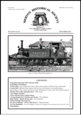
. David Luff warned us that an industrial building is due to be demolished close to the priory wall, but was
delighted to show us a series of photos of Terrier 0-6-0 locomotives of the London Brighton and South Coast
Railway, each named after a local place – Merton, Morden, Mitcham, Wimbledon, Sutton, Carshalton and
(appropriately) Tooting (see p.1). He had himself photographed the results of a 1964 incident near Wimbledon
station, a minor collision with derailment of goods trucks, and the subsequent arrival and working of a
breakdown train with a huge crane
(below).
MERTON HISTORICAL SOCIETY – BULLETIN 211 – SEPTEMBER 2019 – PAGE 5
. Madeline Healey recalled that her family were evacuated to Worcester in 1944, and that one day her 14-yearold
brother climbed a high hill from which he could see the sea to the west, later reporting breathlessly that
it was ‘completely covered with ships’. The date was 1 June, five days before D-Day.
. Judith Goodman may resume her ‘The Wandle in Literature’series, having recently noticed two poetic
references. The first is in Ursula Fanthorpe’s Rising Damp, from her collection Standing To (1982), where
the river is mistakenly listed among ‘Effra, Graveney, Falcon, Quaggy / Wandle, Walbrook, Tyburn, Fleet’as
being underground and out of sight. This is perhaps forgivable, as Fanthorpe (1929-2009) was a northerner.
The second poem is by Carol Rumens (b.1944, Forest Hill), who much more favourably gives us a complete
sonnet in The River Wandle, Beddington, probably from the Croydon Advertiser (c.1971).
. David Haunton had been contacted by the owner of a painting by the artist Dewey Bates (via a notice on
Cookham community website – the only response in four years!). Dave swapped a copy of our booklet on
Dewey for a photo of the painting, which is a view of 38 Red Lion Square in Bloomsbury, London, and was
obviously painted during Dewey’s residence at 7 Red Lion Square in the winter of 1881. As a townscape in
the rain, this is most untypical of Dewey’s work, but was agreed to be rather good.
We discussed a query from Sarah Gould about squatters in the ‘hutted camp’on Prince George’s playing
fields in the late 1940s. (See article on p.12.)
. Peter Hopkins reported a query over the caption
The Society has been given a collection of items from the
estate of Alexander Hendry Watson, by his grandson Mark.
Alexander was born in Dundee in 1901, joined the Navy in
1919 as a boy entrant, became a stoker, travelled the world
collecting photographs and postcards, left the Navy in 1946,
and eventually retired to St Helier Avenue, Morden. He
served throughout the Second World War, ‘minesweeping’
he told Mark, but actually on exhausting Atlantic and Arctic
convoy escort duty (left). (Article forthcoming.)
on one of Monty’s slides published on our website
(right). This is http://mertonhistoricalsociety.org.
uk/mhs-em-rav-32,
which
Monty described
as showing 1940s prefabs in Morden Road,
Mitcham, built on former bleaching fields. The
houses in the photo are not what one normally
thinks of as prefabs, but there was a variety of
forms of prefabricated buildings at that period.
Does anyone know anything about these houses?
Acurrent resident of Phyllis Avenue, Motspur Park, has observed a rectangular crop mark on her lawn during
the recent very dry weather, and wonders if it might be the foundations of an old farm building. The outline
is 7 feet 6 inches by 3 feet 7 inches and roughly 16 feet away from the house. It is too small to be a WW2
air-raid shelter. Furthermore, the buildings of Blue House Farm were some distance to the west of her house,
as were Charles Blake’s villa developments along West Barnes Lane. The lady plans to lay foundations for
a rear extension and will let us know what is uncovered.
The churchwarden of St Lawrence’s has passed Peter a copy of the recent petrology report on the stonework
of the east window by Dr Kevin Hayward of Pre-Construct Archaeology Ltd. It details three different rock
types and two kinds of brick, with surprising implications.
Peter will follow these up with further research
and a future article.
. Rosemary Turner showed us a hoot of a typescript of Mornington Crescent made easy by Howard Bird, of
Ongar Road, SW6, possibly never published, and a collection of items colour-printed on small silk squares,
originally distributed in cigarette packets,along with cigarette cards. They included a wide variety of flags and
badges, and some quite elaborate portraits of ‘the great and the good’ of the early 20th century (opposite).
MERTON HISTORICAL SOCIETY – BULLETIN 211 – SEPTEMBER 2019 – PAGE 6
David Haunton
Dates of next Workshops: 2.30pm on Fridays 13 September, 18 October, 6 December 2019.
2.30pm at Wandle Industrial Museum. all are welcome.
WINDSOR FLOORS
(the continuing story)
Mick Taylor was at Merton Heritage Centre looking for something
completely different when he came across this advertisement for
Windsor Floors Ltd in the Mitcham Official Guide for 1938.
It was presumably composed in 1937, ready for inclusion in 1938.
May we detect a little desperation in the phrase ‘available for an
immediate start’?
Notable in the list of ‘items of work actually constructed’
are
‘Cinema Balconies’
and ‘Proscenium Beams’, implying recent
work on a new cinema. Significant signs of the times are the
mentions of ‘ARPTrenches’and ’50 man shelters for factories’,
which had begun being put out to tender in autumn 1937, due to
the war scare that preceded the Munich Agreement.
MICK TaYLOR
We have pleasure in recording that Mick Taylor has been awarded
‘Volunteer of the Year’for Merton Libraries and Heritage Service.
Sarah Gould nominated Mick, describing him as the ‘cavalry’of
the Heritage Team. The outgoing Mayor of Merton, Councillor
Mary Curtin, presented the award at the Merton Arts Space on
Tuesday 14 May, with Councillor Nick Draper and the MVSC
Chief Executive, Khadiru Mahdi, in attendance.
MERTON HISTORICAL SOCIETY – BULLETIN 211 – SEPTEMBER 2019 – PAGE 7
‘THE VILLaGES OF SUTTON’
On Saturday 13 April 2019, some 35 members and guests were privileged to hear John Phillips speak of his
original research into the history of the five villages now rather arbitrarily grouped into the London Borough
of Sutton. Indications include
archaeology, Domesday Book, descriptions of medieval manors, maps, plans
and current layouts, and surviving early buildings. Our five small villages emerged as hamlets along the spring
line, where the clay meets the chalk, on poor quality soil. The medieval north-south manors are long and thin,
with both types of soil. Bronze Age and Iron Age items are found all over the area.
The Village London Atlas (1986, The Alderman Press) p.168, map surveyed 1861-8
(Alas, much of Beddington is printed across the book’s central gutter.)
Beddington had a Roman villa, occupied over a long period, possibly with a settlement around it. Anglo-Saxon
finds date from the 5th to the 7th centuries. Domesday Book has two entries: Beddington Home with a church,
and also 15 houses in London, while Bandon has no church and is smaller. In the 13th century there was a
separate 200-acre manor, ‘Huscarles’, to the north, apparently cut out of the main manor. When the Carew
family took both manors in the 14th century, their manor had a church to the west of the village centre, on the
Wandle flood plain, and the house was not a direct successor to the Roman site. From the 16th century it was
operated as a closed village, incorporating a large stretch of the Wandle without mills.
Wallington was very small, with a few large houses and cottages, and no church, maybe part of Beddington.
However, the Domesday evidence indicates another north-south strip, and Woodcotes manor to the south, which
hints that Beddington was carved out of a larger Wallington [which was and remained the name of the Hundred].
There were houses on the wetlands near the river; but floods in the early 14th century removed them. There
is a chapel with (most unusually) graves, hinting at Royal ownership, and perhaps that it was once important
but declined to insignificance. Industry developed along the river frontage in the 18th and 19th centuries,
accompanied by much housing for workers.
Carshalton had a Roman villa west of the present church on the site of a previous Iron Age ‘house’, with
continuity into and beyond the Saxon period. Alot of Roman coins and pottery were scattered around, so possibly
this was not the only villa. Domesday shows at least one major subdivision (held by Geoffrey de Mandeville)
but identifying where the boundaries were is very difficult. The church is mainly 12th century and by the 13th
century the village had its own market. A number of narrow medieval houses, showing the street plan, survived
to be photographed in the late 1800s. By 1600 it was a large scattered village, with perhaps three large houses,
while by the 18th century there were at least six, owned by rich Londoners. Carshalton became famous for
horse racing, with a long thin race track running south-west to Ewell. With a long river frontage, there were
five mills in the village alone,as well as ornamental ponds for the gentry. The 18th century saw major building,
with houses packed in – by 1801 the village was really big.
Sutton has two churches, but no accompanying Norton (was there one down the hill?); it has very bad farmland,
but was quite a substantial village, with a sprawling line of houses down the High Street with large gaps between
them. Originally owned by Chertsey Abbey, it was later run as a closed village. The number of tenants plummeted
in the 20 years after 1496, possibly because the wool price was very high, so people were thinned out to be
replaced by sheep. However, the London Clay was ploughed before the early 14th century, but then floods and rain
for several years c.1300 may well have caused a loss of ploughland. (This recently-documented very wet period
MERTON HISTORICAL SOCIETY – BULLETIN 211 – SEPTEMBER 2019 – PAGE 8
seems to have had an enormous impact on all the claylands in Surrey.) There are very few traces of medieval
buildings in 19th-century photographs; it seems there was a lot of demolition in Tudor or Stuart times, and a
change to industry, with lime kilns and huge pits from chalk mining. There is also a colossal sand pit with no
tradition about it, which must have been for bricks. In the mid-18th century the road was turnpiked -the Cock and
Greyhound pubs date from then – and a change of occupation to servicing road traffic. The population was still
very low in 1891, but the area boomed with the coming of the railway and its associated property development.
Cheam is in two parts: Upper in the west with the church, and Lower to the east. There is a lovely detached
chapel dating pre-1066, its tower possibly Saxon (with double hoop windows). In 1066 the estate belonged to
the archbishop of Canterbury and remained high status later; there is a reasonable number of early / medieval
buildings down Broadway, with chalk chequers and their gable ends to the road. There are hints that Broadway
was largely built up, because
some gable-end buildings look really squashed in. Cheam had a big medieval
pottery, which sent much output to London. The sheer number of 17th-century houses in the High Street shows
that c.1600 the direction of traffic flow changed from north-south to east-west (to Ewell).
VISIT TO MERTON PRIORY CHaPTER HOUSE
Our host, John Hawks, summarised the various archaeological campaigns that had investigated the priory site,
and reminded us that the 12th-century remains on display are actually the foundations of the chapter house, and
would not have been visible after the building was complete. He contrasted them with the pre-stressed concrete
bridge carrying the A24 and forming the roof. John spoke of the complexity of legal agreements currently in
negotiation – the site is owned by Merton Council, the ground outside by Sainsbury’s, the bridge by Transport
for London, and the pylon by the London Electricity Board. The walls defining the site are not allowed to touch
the bridge, there are restrictions on heating, and there is no water supply or drainage yet (after access is agreed,
Thames Water will still have to find the relevant pipes).
However, we were free to admire the effects of the improvements
of Phase I, starting with the new entrance. Fascinating for an
engineer, the mechanism allowing the expansion and contraction
of the bridge (due to temperature changes) is fully visible. Lots
of light through what is virtually a wall of windows on the south
side lifts the previous gloom, overlooking a set of information
boards (designed by John’s daughter Katie) in echelon, down
the length of the site (right).
Much of the recovered
ornamental stonework is on
display between the boards,
similar blocks being grouped
together to give
effective
impressions of the masonry
detail. The display includes
four blocks, which have only
recently been recognised as belonging together, forming most of the upper
part of the tracery of a window (above). A panel of floor tiles (modern,
but reproducing medieval designs found on site) gives a good impression
of the richness of the priory floors (right).
Further information on the priory is offered on a series of boards across the end of the site, with lots of space in
which to browse them, big enough to hold 150 seats for an audience during musical or theatrical performances.
The third side of the site is devoted to notes on other local heritage ‘people and places’, including an interesting
exhibit on William Morris, who was attracted to the site by the abundance of clean water, rather than by the
priory. A visitors’ book is now available to record responses by the public, which to date have been uniformly
positive. One visitor, perhaps younger than most, noted ‘I loved playing with Toby the Border Collie'(John’s
extremely well-behaved dog). Free entry, of course – well worth a visit now.
Plans for Phase II, once money is found, include paving the ‘floor’
of the chapter house, to improve it as a
performances pace, and conversion of the weed-patch outside into a ‘physic garden’,growing the sort of healing
plants that would have been cultivated in the priory’s heyday, to assist in its rôle as the local hospital-cum doctor’s surgery for the local population as well as for the canons.
David Haunton
MERTON HISTORICAL SOCIETY – BULLETIN 211 – SEPTEMBER 2019 – PAGE 9
PETER HOPKINS has been speculating about
CURVING BOUNDaRIES IN MORDEN aND MERTON
As part of ongoing research into medieval Morden, I have attempted to identify the origins of that part of the
manor of Ravensbury that lay within the parish of Morden. There seems little doubt that the manor was formed
from two pre-Conquest estates, of Lang and Lemar respectively, which both came into the possession of William
fitzAnsculf following the Norman Conquest and were held from him in 1086 by William de Tancarville I,
chamberlain to the Conqueror. Lemar’s estate was said to be in Mitcham, while Lang’s was in ‘Witford'(more
commonly spelled as Wicford). Later evidence indicates that this Wicford estate was entirely within what was
to become the parish of Morden, though an adjoining estate in Wicford, held in 1086 by Odo bishop of Bayeux,
probably included land in Morden, Mitcham and Carshalton around the ford that preceded Mitcham Bridge.
Some land from the former Bayeux estate at Wicford was purchased by 14th-century lords of Ravensbury, the
remainder probably being the holding administered from a manorial centre on the Mitcham Grove site, though
the medieval moated site at Mitcham Hall might have been associated with it at some time. Mitcham Grove
was excavated by MHS and Surrey Archaeological Society in 1974-5 under the direction of Dr David Bird,
the former Surrey County Archaeologist, and he has now gathered the finds together to begin a full analysis.
As part of his background research he asked me what is currently known about Wicford.
Within Morden, the boundary between the two Wicford estates appears to have been the eastern edge of what has
been described as an ‘oval’enclosure, a boundary still marked by the modern Moreton Green. (This enclosure is
shaded yellow on the map below.) In the 15th century this enclosure had been called ‘le Hunderacrys’ and some
of its later subdivisions retained the Hundred Acres name into the 18th century. My attention was drawn to this
enclosure many years ago by John Pile, who was aware of similar ones in Hampshire which are considered to
be early enclosures for settlement or agricultural purposes. The remains of a Roman villa have been discovered
in the one at Bury Lodge, Hambledon, Hants (58 acres), and John had initially compared the -bury name (here
meaning estate
centre) with our own Ravensbury – or Ersbury/Arsbury in its earliest known form. However,
another such enclosure, at Beckford, Hants, has been interpreted as an early stock enclosure which, at 99 acres,
is about the same area as our Morden example.
Place-names that include the element wic are thought to have related to a former Roman site (vicus), or to a
trading port – such as Lundenwic/Aldwych (just outside the Roman city of London), Hamwic (Southampton),
Sandwich and Fordwich (both in Kent), or a place of specialised food or stock production – such as Gatwick
(goats) or Chiswick (cheese).1 Could Morden’s ‘oval’enclosure have been part of such a wic? David Bird was
Berefurlong
Based on the tithe maps but with an extract from the 1860s Ordnance Survey
map superimposed to cover that area of Merton parish not subject to tithes
MERTON HISTORICAL SOCIETY – BULLETIN 211 – SEPTEMBER 2019 – PAGE 10
politely sceptical – it would be unusual to find wic used in this sense without a descriptive first element. When
it is the first element, as in Wicford, it is more likely to refer to a nearby Romano-British site. (Place-name
expert Richard Coates has since confirmed that, although Wicford could be interpreted as ‘ford by the ‘wick’
or by the place called ‘the Wick”, he is not aware of the use of wic as a standalone until after the Conquest.)
David also pointed out that the curve of the southern boundary of the ‘oval’continued towards Central Road,
perhaps indicating a larger area than that occupied by the Hundred Acres – in fact the entire extent of my
reconstruction of Lang’s former Wicford estate, as outlined in green on the map – some 130 acres.
David also commented on an interesting series of curved boundaries within Merton manor, though he wisely
refrained from offering any interpretation of their origins. I have marked them in turquoise on the map. I had
long been aware of the two small ‘ovals’in the vicinity of Merton Rush (the Nelson Hospital site) -which John
Pile points out was originally a single oval, as the corners of the lane dividing them are right-angled – and of
the larger oval adjoining on their eastern border, which extends to the old parish church and includes the former
Church House site, though the boundary is more angular in that segment. I have hypothesised elsewhere that
this could well have been the Norman manorial centre and the site of sheriff Gilbert’s original priory buildings.2
Lacking David Bird’s wisdom, I am engaging in wild speculation! Were these ovals the sites of the earliest
Saxon settlements in this section of the parish, as people
moved out from the Roman site by the Wandle?
The 1844 tithe apportionment schedule reveals that, in the mid 19th century, most of the fields within these
boundaries were used for arable cultivation, except those taken into the grounds of the larger houses. Was the
block of land immediately to the east of the largest enclosure the core from which the later fields expanded? Do
the other curving boundaries radiating from this core represent successive limits of cultivation, until it reached
the Wandle in the east and the boundary with Morden in the south, only stopping towards the south-west when
it reached that area which remained common pasture until Merton Common was enclosed in 1816?
At the time of its enclosure, the Common (outlined in orange on the map) extended westwards beyond the line
of Cannon Hill Lane (the ancient lane from Lower Morden originally called Bow Lane), and it is likely that
it had extended even further westward at an earlier period. However, the Ordnance Survey map also shows a
series of curving boundaries (marked in purple) radiating from Bakers Farm at the junction of Kingston Road
and Cannon Hill Lane. John Pile points out that the farm also had rounded corners on its eastern edge, though
not on its western boundary by the time the map was drawn. These radiating boundaries continue as far as West
Barnes Lane. Most of the land to the west of Cannon Hill Lane was tithe-free and so its land use was not set
out nor its field boundaries depicted on the tithe map. However, surviving 16th-century sales particulars and
leases reveal that the land belonging to what was to become Bakers Farm was predominantly used as meadow
and pasture, while the adjoining 60-acre Cannon Hill estate was described as woodland in 1613. If it had been
exploited as arable in the early medieval period, it is likely that it soon proved unsuitable for such cultivation.
Further north was Bushymede or Rushymede – still liable to flooding into modern times.
West of Bakers and Cannon Hill was the huge farm known as West Barnes, a name first noted in 1292 and
which clearly indicates the need for storage of the crops grown at this end of Merton. Certainly in 1844 the tithe
apportionment reveals that two of the four farms carved from the former West Barnes estate were mostly under
arable, apart from the meadows alongside the Pyl and Beverley brooks, though neither Bluehouse Farm nor
West Barnes Park were subject to tithe so their land use was not recorded. However, the latter was described in
1834 as having been ‘nearly all under the plough’ at the end of the previous century but had been ‘subsequently
laid down to grass’.3The purple boundaries extend to include the whole of this section of the estate.
There is one curved boundary (marked here in pink) in the north-western section of the West Barnes estate,
along the boundary between arable and meadow north of the old moated farmhouse. This is my only curved
boundary to follow a geological division -around an ‘island’of London Clay in a’sea’of gravel, marked also by
a 15-metre contour. However, the southern boundary of Merton Common at the time of enclosure also followed
the edge of the London Clay which covers most of Morden and reaches the 30-metre contour at Cannon Hill.
Tempting as it is to interpret these radiating boundaries in Merton parish as the gradual expansion of cultivation
from the earliest clearings represented by the oval enclosures, a more mundane explanation is possible. Tithe
plots 141-142 (here marked by a light pink straight line) preserve a 1.5-acre strip from the medieval Berefurlong
that had remained part of the Merton Cottage copyhold. At around 200 metres or 220 yards – 1 furlong – this
would have been themaximumlengththatateamofoxencouldploughafurrow.Weretheseradiatingboundaries
merely the remnants of the units constituting the medieval open field -the furlongs? However, this alone would
not explain the curves of the boundaries – only the purple boundaries west of Cannon Hill Lane follow the
curves of the contours – so perhaps the two explanations are complementary rather than contradictory.
R Coates ‘New light on old wicks: the progeny of Latin vicus’ in Nomina (1999) pp.75-2 A Priory Founded: Sheriff Gilbert at
Merton (2019) p.7
116; P Drewett, D Rudling & M Gardiner The South-east to AD 1000 (1988) p.297
3
E M Jowett Raynes Park: a social history (1987) p.26
MERTON HISTORICAL SOCIETY – BULLETIN 211 – SEPTEMBER 2019 – PAGE 11
HELP WaNTED – BUSHEY ROaD CaMP
Earlier this year, Sarah Gould was contacted by Rebecca Riley, who spent her early years living with her parents
in a ‘hutted camp’off Bushey Road. This describes an army camp, or temporary military accommodation, which
was used to house families during the immediate post-war era. Rebecca is keen to get more information on the
site – its origins and details of its use in the late 1940s.
According to the Wimbledon Boro’ News, 17 families moved in as squatters to the unoccupied prisoner-of-war
camp on the Prince George’s playing fields in Bushey Road, Raynes Park, shortly after February 1947. This had
originally been an anti-aircraft gun site, and had then housed German prisoners of war (POWs), who, according
to an article in May, were finally moved out ‘several weeks ago’. The paper reported that the response of the
War Department, the site owners, was to immediately make the rest of the huts uninhabitable.
When Rebecca’s father returned from WW2, her parents lived for a short period
with her mother’s parents in Cannon Hill Lane before squatting at the camp. The
location of the camp is correct and the fact that it was military or War Department
property at the time also fits with what Rebecca was told. However she was also
told that it was a depot for military vehicles and trucks
with buildings that the vehicles were kept in, has no
memory of it being described as a POW camp, and is
sure that if her parents had been aware of this it would
have been passed on. Rebecca has two pictures of the
Riley ‘Hut’. In the first picture (left) the child standing
on the path is her sister, perhaps three years old. She
was born December 1947, implying the family are in
residence in 1950. The second photo (right) is of Rebecca’s mother holding a very
young child, probably Rebecca herself, born in August 1951, with the family still
at the camp. They were rehoused when the newly built maisonettes in Hatfeild
Mead, Morden, were completed in 1952.
The 1946 Electoral Register for the Merton and Morden Parliamentary constituency has no relevant entry.
However, the 1947 Register, polling district ‘O’, lists 59 voters living in ‘The Camp’by the qualifying date of
30 June 1947, including Arthur and Gladys Riley, Rebecca’s parents. (Recall that the Registers of the time list
only those adults aged 21 and older, so children and young adults are not mentioned.) Presumably by that date
Merton and Morden Council had come to a satisfactory arrangement with the residents for the payment of (at
least) water and electricity bills. The November 1948 Register then lists voters in numbered residences within the
‘Hutted Camp’, up to no.54. Twelve numbers between 1 and 54 are omitted from the list and are thus presumably
empty. Most of the other 42 have at least two occupiers. Afew have two families, given different ‘addresses’,
such as the Riley family at no.9b, with the Saunders family at no.9a. The June and November 1949 Registers
(nowin Polling District ‘D’) have a highest address of no.51, and show five addresses in twin occupation (nos.12,
19, 27, 29 and 36) and reveal that the Riley household is one of three at no.9. In the November 1950 Register,
the ‘Hutted Camp’has become the more respectable ‘The Close’, leading off Bushey Road, which presumably
shows the Post Office getting involved: presumably also this indicates the main entrance to the settlement was
from Bushey Road, rather than Grand Drive. Thereafter the number of residents reduces, as the Council rehouses
families; By November 1951 the highest house number is no.37, in 1952 it is no.32, by October 1955
only eight people remain in five houses, and these have all gone by October 1957. The Riley family were in
‘The Close’in November 1951, but had moved to 130 Hatfeild Mead by November 1952, after a documented
stay in squatter accommodation of at least four years.
I assume the accommodation was based on Army Nissen huts, but it is puzzling. These huts normally had only
one storey and only one entrance, whose door frame reached higher than the windows (below, foreground).
At least five of our huts must have had two entrances (for two families),
whereas no.9b obviously had two storeys, with windows reaching higher
than the door frame, as well as two other entrances (for no.9 and no.9a).
The shape is also odd, as it does not match the Quonset hut design or the
much bigger standard ‘permanent’British Army hut. This picture of an
Army camp from a TV documentary shows a rather bigger hut (centre rear)
which might
be the sort inhabited by the Rileys. Does anyone have any
thoughts about huts, or photographs or memories of the Prince George’s
Playing Fields camp? David Haunton
MERTON HISTORICAL SOCIETY – BULLETIN 211 – SEPTEMBER 2019 – PAGE 12
MERTON HERITaGE DISCOVERY DaY
This annual event was a considerable success all round. An increased number of organisations was present –
even Merton’s Artist in Residence, Mark Goldby, not usually in the building, was around and happy to discuss
the state of his research into the history and connections of the Gorringe Park house he currently lives in.
Mark’s work-in-progress
board in Morden Library
The programme of short talks attracted full audiences, with standing room only for most of them. Sarah Gould
reported that it had been the most well attended such event to date, with well over 2000 visitors flooding in
during the four hours that the doors were open. She overheard comments such as ‘This is wonderful’and ‘This
is far more than I expected’, while one feedback form noted ‘People running the exhibitions are very keen and
knowledgeable so this is nice’. (The circulating cake trolley for stallholders was also nice, and appreciated.)
Our stand featured a large range of our
publications and a slide show of the pictures
from Keith Penny’s recent talk on ‘History
by Bus’, which attracted almost continual
attention. We sold around £90-worth of
publications (we sold out of copies of some
titles!), had two invitations to give talks, spoke
almost continually to visitors, met friends and
members (right), and collected a subscription
from a not-intentionally-lapsed member. Keith
gave one of the short talks, on Homes Fit for
Heroes, which was well received (see p.3). A
good afternoon for MHS, if wearing for our
elderly legs!
Stop Press: Heritage Discovery in action
Surrey Archaeological Society plans a Community Test-Pitting Weekend at Nonsuch Park for Heritage Open Weekend 21-22 September.
See their website www.surreyarchaeology.org.uk A cunning plan by Mick Taylor ensured that Sarah Gould gave the last of the
short talks,
so that when she finished there was a ready-made audience for a presentation to her of
some gifts from friends and local organisations, to congratulate her on 25 years as HeritageOfficer for Merton. Mick had
collected so much from everyone that he confessed he had
to think hard about what to get. He eventually chose an inscribed Bohemia Crystalite
Vase (right) for formal commemoration, and, to reflect Sarah’s interests, a Suffragette
teapot and scarf, many films and books, and flowers in Suffragette colours. Nicely done!
MERTON HISTORICAL SOCIETY – BULLETIN 211 – SEPTEMBER 2019 – PAGE 13
MICHaEL POLLOCK continues his wanderings down Memory Lane
MY LIFE IN MITCHaM – 1939 to 1966 (PaRT 2)
One day I went with my father to Croydon by the 630 trolley bus – a lovely form of transport, with no fumes
and very quiet. I often wonder why they were stopped, and if they may be brought back again. While shopping
in Croydon I visited an electrical store, and while I was in the shop was offered an old radio free which I
accepted. It needed a large 120-volt battery, two 2-volt accumulators and a set of headphones. My father took
me to Pasco’s Radio shop in Gorringe Park Avenue to buy the batteries and accumulators for my radio. I had
to take the accumulators back to the shop for charging occasionally. Sometime later I managed to get hold of a
‘battery eliminator’which meant I no longer had to buy a large 120-volt battery and also meant I did not have
to go to have the accumulators charged. The radio now ran off the mains. It was nice to listen to the radio before
I went off to sleep. Sometimes while trying to get to sleep, I could hear the trams that terminated at Longley
Road, just by Tooting railway
station, and on some evenings the sounds of the Wimbledon Speedway riders
racing around the track off Garret Lane, Tooting, just over a mile away.
I then started to get out and about on my bike, riding with my mate to Mitcham Common, with its Seven Islands
Pond. We cycled to Willow Lane and went right to the end of this road where the river Wandle was, and it
had a very strange smell. I have now found out there were various industries there including a leather tanning
company, from which the smell possibly came. One day from home I could see very black smoke rising from
this area, so called in to a friend and we cycled to near Willow Lane, where there was a massive fire at the tyre
dump on that estate which lasted, I believe, several days [June 1947]!
At Gorringe Park County Secondary School, lots of the boys collected stamps, coins, cigarette cards and even
cheese labels, including me. So, at one time I called into the factory at the back of Mitcham Common called
‘The Creameries’as I had heard they had some cheese labels there. I came out with a handful of brand new
cheese labels, which I still have tucked away with my stamp collection (see Bulletin 209 p.1).
During 1953 my father sold my train set and bought me a small printing press which I was interested in.
It was an ‘Adana’, a hand operated machine on which I printed out letter headings with addresses for several
teachers at my school. I also joined the school printing class and really enjoyed printing.
In 1954 it was time for me to start work, and I managed to get an apprenticeship in block-making at Line &
Tone Ltd, in Farringdon Road EC4. This was a process enabling photos to be printed in books and magazines
using various sized dots to give the impression of various grades of black and white. Some of the blocks were
for Fleet Street
papers, such as The Express and Evening Standard. Traveling from Tooting railway station to
Holborn Viaduct was a short train ride. I stayed at Line & Tone for my five years apprenticeship, before moving
on to other companies in London.
Now getting some money of my own (30 shillings a week!) I started to learn to drive and in 1956 due to the
petrol shortage, was allowed to drive on my own with ‘L’plates! Having passed my driving test, I bought my
first car, an Austin 12 for £25, registration BAD 618, from which I learnt a lot about the engine and how it
worked, by fitting new piston rings and grinding the valves. I renovated a lot of the body work, including the
wooden floors. This needed trips to the local car breaker yard in Merton via Longley Road, to get parts to replace
damaged ones, and to car accessory shops to buy vinyl covering for the doors. The car looked a lot smarter than
when I bought it. Some of those trips were made by bus while the car was in bits!
My father started a Mitcham Cine Society held in our
home at that time, as he had bought a cine camera from
a colleague at his work place. I used to cycle to the
Majestic cinema at Fair Green every week to pick up the
16mm trailers of new films and also the posters of new
films.Sometimes I even went up to the projection room
right at the top of the building to collect the trailers.
Occasionally we went to Glebelands old people’s home,
showing travel, comedy and documentary films and
trailers to them. Once my father and I went to Three
Kings’Pond where Mitcham Fair was held every year.
The Mayor that year was Mr Mount [1953], recorded
on film by my father.
One of the members of the Cine Society was Leo, who
owned the ice cream parlour in London Road, near the
My father is in the photo with cine camera and tripod, with me
just in the photo at his side behind the camera.
© Phox-Studio
MERTON HISTORICAL SOCIETY – BULLETIN 211 – SEPTEMBER 2019 – PAGE 14
town hall and fire station. Leo’s made a three-colour lolly with ice cream in the centre, with orange and red
flavouring on the outside which was really nice and refreshing. The end of the Cine Society soon came, brought
about by members staying at home and watching a commercial television station called ‘ATV’that had started
up on 22 September 1955.
There was a scrap wood site opposite the Mitcham
Baths where I could buy second hand wood. I was
told it was from a BBC scenery department. I used
this wood to build no end of things in my father’s
workshop. One of the items was a desk in my bedroom
with sound equipment with switches, turntable and
radio units (left).
My father had got interested in tape recording after the
Cine Society ended, and bought a semi-professional
tape recorder. On 7 March 1958 at the Mitcham Baths,
there was a competition for the best music group in
the Mitcham area and he asked if he could record it
all. There were ten groups to enter the competition,
some were skiffle groups and others were beat groups
with electric guitars, drums and a singer. The winning
group in the competition were Rock-a-billy Boys and
second were Pat Cresswell and the Blue Hounds. Other groups at the competition were The Renegades skiffle
group, The Downtowners, Blue Stars, Torpedoes, Vampires, Amazon Five, Streamliners skiffle group and
The Chessmen. To enable better recording I had built electronic equipment with my father, such as the mixers
and amplifiers needed for three microphones. Several of the groups then wanted records ‘cut’to play on their
radiograms, or Hi-Fi set up if they had one, so we started
to record them and make the records ourselves on
second hand disc cutting equipment. Most of these tapes I still have, still in excellent condition!
In 1960, I left Line & Tone after I had served my apprenticeship. I moved to Star Illustration in Wardour Street,
London, where I became a ‘journeyman’ (experienced person), which enabled me to earn better wages.
That same year, while reading Tape Recording Magazine, I learnt that
they had organised a competition. I then thought I would try my luck
and entered a recording I had made on a portable recorder. It was made
during a holiday evening at Lydd, Kent, while watching and recording
a firework display, when some local army lads were shouting out
remarks about the fireworks. When I got home from holiday I edited
the tape by transposing several parts of the recording and also cut it
down from 14 minutes to four minutes duration for the competition.
Me with the recorder I used © Robert Locke
I entered the finished tape into the ‘Actuality’
section of the competition and came first.
The prize was lunch at the Savoy, and visits
to the EMI factory in Hayes, Middlesex,
and the EMI recording studios at St. Johns
Wood (since 1970 it has been called the
Abbey Road Studios). In the evening I was
presented with some tapes and other prizes
by Josephine Douglas, who had been the
presenter of Six-Five Special, the first pop
chart TV show, during 1957-58.
Photo taken in 7 June 1956 © Mitcham & Tooting Advertiser
(Front Page!)
Myself, Josephine Douglas and my father (on the right in glasses),
© EMItape Division
MERTON HISTORICAL SOCIETY – BULLETIN 211 – SEPTEMBER 2019 – PAGE 15
I was then asked if I could help out at an amateur theatre group in Carshalton, doing the sound effects on tape.
At that time these were normally played on 78rpm effects records on a ‘Panatrope’, which is an old type of
record player. This group was called the Harlequins Theatre Company and I stayed with them for several years
working on the sound effects and general ‘mood’music and interval music. We once went to Ireland representing
England, in competition against Scotland, Ireland and Wales, but only came runners-up.
While doing this theatre work in Carshalton I met my wife to be. She had been working making the scenery for
one of the shows; her name was Moira and she lived locally. We got married in 1966 and moved to a rented flat
in Coulsdon before settling down in our own house some 18 months later in Burgess Hill, Sussex. This is not
too far from Brighton, where there is always something going on, such as the veteran car rally in November,
with the route passing through Burgess Hill, and mini-car
and Austin 7 rallies etc. down in the town. Sadly,
after almost 43 years of marriage, Moira passed away from liver cancer in 2009. RIP.
I’m still living
in the same house, for 50 years now, with our two daughters and four grandchildren not too
far away. I’m very grateful to my parents for caring for me during the war years, and for the vast knowledge
I received from my father over the years. This has helped me in my work and at home to build projects in and
around our home. In 1976 I left the printing trade and moved into the electronics industry, building equipment
just as I had done twenty years previously. In fact, when I left school, I had been offered a job at Sun Electrical.
I don’t think the word electronics had been used much in those days. I have very nice memories of Mitcham
and my upbringing in the area, and often wonder what other children in the area managed to achieve in their
lives and where they are now.
FOR YOUR BOOKSHELF
The Glass Bulldog by alison Huntingford (2019, austin Macauley, £9-99)
Unusually for the Bulletin, this is a novel. However, the author says that, though it is a
fictionalised account, all the main events actually happened in her own family history. Covering
the trials and tribulations of a working-class life for more than fifty years from 1832 to 1885,
the locations include Devon, Godalming and Mitcham. The Editor has been kindly supplied
with a review copy, and seeks a Mitcham or Godalming reviewer. Volunteers please.
A History of Cranleigh Lawn Tennis and Social Club 1929-2019 by Peter McCandless
(£3-00, available at the clubhouse in Cranleigh Road on Tuesday, Thursday, or Friday evenings)
To celebrate their 90th anniversary, this thriving club has just published a lively and well-illustrated account
of the first 90 years, with proper attention paid to both highs (Surrey LT Club of the Year 2018/2019) and lows
(the club-house burned down, 1975). (See Bulletin 206, June 2018, p.3.)
SUBSCRIPTIONS
A membership renewal form is included with this Bulletin. Only paid-up members may vote at the AGM.
From 1 October 2019 rates are:
Single membership £12 Additional member of same household £5
Full-time student £5 Overseas members by arrangement with the Membership Secretary
If you already pay by Standing Order, please still return the completed renewal form.
The AGM agenda is also enclosed, together with the minutes of last year’s AGM.
MHS is bound by the EU General Data Protection Regulation.
Please see the MHS website regarding how this concerns your personal data.
Letters and contributions for the Bulletin should be sent to
the Hon. Editor by email to editor@mertonhistoricalsociety.org.uk.
The views expressed in this Bulletin are those
of the contributors concerned and not necessarily those of the Society or its Officers.
website: www.mertonhistoricalsociety.org.uk email: mhs@mertonhistoricalsociety.org.uk
Printed by Peter Hopkins
MERTON HISTORICAL SOCIETY – BULLETIN 211 – SEPTEMBER 2019 – PAGE 16