 MERTON HISTORICAL SOCIETY
 Bulletin 183
Download Bulletin 183
September 2012 Bulletin 183
History is Made in Merton This Summer M Taylor/C Roe
An ‘Ancient Relic’ and its Future J A Goodman
Some Aspects of the Bulletin’s History D Haunton
Merton Park’s Level Crossing G Wilson
389-393 London Road, Mitcham C Reid
and much more
Hon. Secretary: Membership Secretary: Hon. Secretary: Membership Secretary:
PRESIDENT:
VICE PRESIDENTS: Viscountess Hanworth, Eric Montague and William Rudd
CHAIR: David Haunton
BULLETIN No. 183 SEPTEMBER 2012
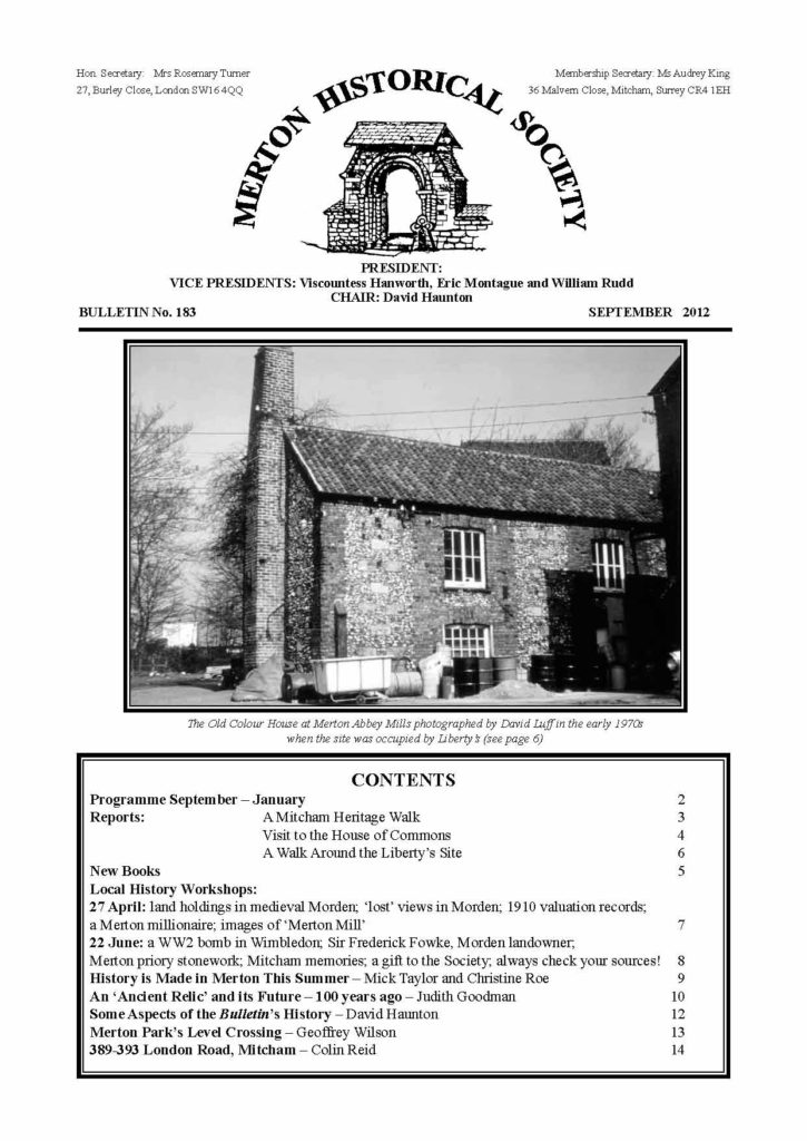
The Old Colour House at Merton Abbey Mills photographed by David Luff in the early 1970s
when the site was occupied by Liberty’s (see page 6)
CONTENTS
Programme September – January 2
Reports: A Mitcham Heritage Walk 3
Visit to the House of Commons 4
A Walk Around the Liberty’s Site 6
New Books 5
Local History Workshops:
27 April: land holdings in medieval Morden; ‘lost’ views in Morden; 1910 valuation records;
a Merton millionaire; images of ‘Merton Mill’ 7
22 June: a WW2 bomb in Wimbledon; Sir Frederick Fowke, Morden landowner;
Merton priory stonework; Mitcham memories; a gift to the Society; always check your sources! 8
History is Made in Merton This Summer – Mick Taylor and Christine Roe 9
An ‘Ancient Relic’ and its Future – 100 years ago – Judith Goodman 10
Some Aspects of the Bulletin’s History – David Haunton 12
Merton Park’s Level Crossing – Geoffrey Wilson 13
389-393 London Road, Mitcham – Colin Reid 14
PROGRAMME SEPTEMBER – JANUARY
Saturday 22 September 2.30pm St Martin’s Church, Camborne Rd, Morden
‘Memories of Morden Between the Wars’
A ‘Chat Show’ hosted by Peter Hopkins, with guests who grew up in Morden in the 1930s
and whose families lived in Morden before suburban development here.
Free to all! St Martin’s Church is at the junction of Camborne Road and Queen Mary Avenue. Buses 163 and
293 stop in Hillcross Avenue (The Beverley) opposite a footpath at the side of the church. 163 and 413 stop
in Grand Drive near the Co-op, with access along a short stretch of Queen Mary Avenue. Limited parking.
Thursday 11 October at 11am Visit to Freemasons’ Hall, 60 Great Queen Street
Free but restricted numbers. Please book with Bea Oliver.
Freemasons’ Hall is a short walk from Covent Garden Underground station.
Saturday 10 November 2.30pm Christ Church Hall, Colliers Wood
Annual General Meeting
To be followed at 3.30pm by Bea Oliver speaking about ‘A History of the Nelson Hospital’
Saturday 8 December 2.30pm Christ Church Hall, Colliers Wood
‘The History of the Christmas Card’
This illustrated talk will be given by Anna Flood, archivist of the British Postal Museum & Archive.
Saturday 19 January 2.30pm Christ Church Hall, Colliers Wood
‘Heraldry – Mostly Local’
a talk by the Chair of Merton Historical Society, David Haunton
Christ Church Hall is next to the church, in Christchurch Road, 250m from Colliers Wood Underground
station. Limited parking at the hall, but plenty in nearby streets or at the Tandem Centre, 200m south.
Buses 152, 200 and 470 pass the door.
Visitors are welcome to attend our talks. Entry £2 apart from the September event.
TO ALL MEMBERS OF THE SOCIETY
Writing as your Chairman, I would ask you to consider the following:
Firstly, I would ask members to consider coming forward as candidates for election to the Committee at the
next AGM. Some of the present Committee have decided not to seek re-election, after two or more years of
service. This means that the number of Committee members will be approaching the minimum set out in our
Constitution: we really do not wish to arrive at the position where the Society can only function by co-opting
members ‘off the street’. The demand on your time is not heavy, as we meet only six or seven times a year. We
mostly need your ideas and occasionally your telephone (though your assistance at Society meetings is always
welcome). If you feel you could help, please give your name to our Secretary, Rosemary Turner.
Secondly, your Committee has been rather depressed by the low attendance at our outside visits this summer,
and we are wondering what we got wrong. Was it the day of the week, the venue, or had you been there before?
Please phone, e-mail or write to me, or speak to me or another Committee member at a meeting – we need
your views.
Finally, may I urge you to consider booking a place on our October visit to Freemason’s Hall. With its rather
grim exterior, the Hall does not appear inviting, but inside it has a riot of Art Deco design and decoration. And
of course it is very near Covent Garden Underground station, and the many interesting shops and cafés in the
surrounding Piazza.
Thank you.
David Haunton
Your AGM Agenda and renewal form are enclosed
MERTON HISTORICAL SOCIETY – BULLETIN 183 – SEPTEMBER 2012 – PAGE 2
A MITCHAM HERITAGE WALK
On 12 May Tony Scott, Vice-Chair of the Society, led a group of members and friends around the Cricket Green.
He explained that Mitcham originally was two hamlets, identified in Domesday as Mitcham and Whitford.
Roman and Saxon remains have been found in the area: for example in 1888 a Roman well was found where
a gasholder was being constructed; remains of a Roman villa have been found in Beddington Lane; and Saxon
burials which date from about AD 450-600 have been found on either side of Morden Road.
The dovecote at The Canons bearing the date 1511 is the oldest complete structure still standing. Old foundations
are sometimes uncovered, such as at the sites of Hall Place and Mitcham Grove.
In 1765 the village lock-up was located where the Vestry Hall now stands, in Lower Green. By 1810 the village
stocks were there too, and, in 1850, the fire-pump, which was replaced in 1884 by a steam fire engine. The
Vestry Hall was erected in 1887 to the design of Robert Masters Chart, who became the first mayor of Mitcham
Borough in 1934. The Hall was used as offices by the Urban District Council from 1915, and as town hall from
1934. The fire pump was housed in the Hall until the fire station behind the Hall was built in 1927. Nearby is
the Portland stone memorial to those who lost their lives in the First World War. Their names are inscribed on
the memorial.
Alongside the Vestry Hall is the Cricketers pub (closed in 2010). The predecessor of the present building was
used as changing rooms for the cricketers before their pavilion was built in 1904. This is unique, as it is separated
from the Green by a road. Cricket has been played on the site opposite the Vestry Hall for over 300 years. Many
well-known cricketers including Alec and Eric Bedser have played here.
The Cricket Green is a Conservation Area. Elm
Lodge was built c.1807 by Edward Tanner Worsfold,
a local maltster. For most of its life it has been
occupied by doctors. It is Grade II listed, for its
architectural and historical importance.
Mitcham Court, previously Elm Court, was built in
1823 for Dr John Parrott, a local physician. It was
extended in the late 1860s by Caesar Czarnikov,
a London sugar broker, and sold to Mitcham
Corporation in 1936 by Sir Harry Mallaby-Deeley
MP, the last resident of the property. If the war had
not intervened it might have become the new town
hall. Instead it served as an ambulance station, and
then as offices for the local housing and public
health departments. It was sold in 1985.
Hall Place, in Lower Green West, was demolished in 1867. It was a multi-period house, with a medieval hall
with exposed roof timbers, a 14th-century chapel, and a priest’s hiding-place. The Hall Place archway, partly
rebuilt by Sir Cato Worsfold in 1914, is all that remains of the private chapel Henry de Strete obtained a licence
for in 1349. The Worsfolds left it as a garden feature in the grounds of the new Hall Place in 1867. This building
was demolished in the 1940s and, later, Cricket Green School was built on the site.
A Sunday School was built in Lower Green in 1788, and became a day school run by the parish church
authorities in 1812. The Forster Education Act of 1870 established a national system of elementary education,
both by supporting denominational schools and building non-denominational schools run by school boards.
The school in Lower Green was transferred to a school board in 1871. In 1884 Mitcham school board built St
Mark’s School for girls and in 1897 Benedict School for boys. The old building became the Parish Rooms, and
was used in 1939 as the local food office.
The Burn Bullock is named after the cricketer of that name, who ran it with his wife until his death in 1954,
after which his wife continued to run it until her retirement in 1975. The pub, then called the King’s Head, was
then renamed the Burn Bullock. The front part is from around the 1760s; some of the windows on the top floor
are filled in to avoid the old window tax. The oldest part is at the back, which dates from the 16th century.
The White Hart was a coaching inn: mounts and post chaises could be hired from the yard. One of the first horse
buses was operated from here, by the Holden family.
This was a very interesting and informative walk, and we thank Tony for sharing his knowledge of the area
with us.
Audrey King
Elm Lodge, photo:Eric Montague 1972
MERTON HISTORICAL SOCIETY – BULLETIN 183 – SEPTEMBER 2012 – PAGE 3
VISIT TO THE PALACE OF WESTMINSTER
On 19 June, Siobhain McDonagh, MP for Mitcham and Morden (and long-term member of our Society), met
14 of us for a lively guided tour of the Palace. This touched on the buildings themselves, Parliamentary practice
and traditions, historic events, and Siobhain’s personal anecdotes.
We began outside, standing on the roof of the MPs’ car park, its security much improved since the 1979 IRA bomb
that killed Airey Neave MP as he was driving out. We viewed Portcullis House, the MPs’ new office building
across Bridge Street, and the Clock Tower (soon to be renamed Elizabeth Tower) containing the bell Big Ben.
Then into Westminster Hall, completed by William Rufus in
1099, and remodelled by Richard II from 1394. This is the
largest and oldest medieval hall in the world, with a superb
wooden roof with carved angels on the hammer-beams (right),
and stone statues of kings before Richard II placed high up the
walls. It was a space used for public events, early councils,
trials (Thomas More, Charles I), banquets, entertainments,
games, shops, lyings-in-state (eg. Churchill, Gladstone and
Disraeli), and recently receptions for Barack Obama, the Pope
and Aung San Suu Kyi. Leading off Westminster Hall is the
medieval chapel of St Mary Undercroft, with low walls and
heavy structural ceiling ribs all now riotously decorated by
Pugin with small gilded and painted motifs, looking more
Orthodox than English.
These two spaces are the only surviving parts of the original
palace, the rest having burned down accidentally in 1834.
The Palace was rebuilt to the designs of Sir Charles Barry
(architect) and Augustus Pugin (decorator for both interior
and exterior) over a period of more than 20 years.
Then to St Stephen’s Hall. This is the site of St Stephen’s
Chapel, above the undercroft. Legend has it that here (or in its Norman predecessor) when the king met his
Council, the Lords sat in the choir stalls, facing one another, which is why the Houses of Lords and Commons
are still laid out that way, and not in a semi-circle.
The Hall leads to the Central Lobby, between the Commons and the Lords. This is a large octagonal space, with
large part-gilded mosaics of the four patron saints over the four doorways. The archway leading to the Commons
still shows superficial war damage: Churchill pressed for it not to be repaired as it shows ‘how narrowly we kept
democracy’. The Lobby holds the Whips’ offices and statues of notable Parliamentarians: at present Churchill,
Lloyd George and Attlee are accompanied by Thatcher (controversially commemorated while still alive). Any
constituent can still come here in person and demand to speak to their MP (hence the phrase ‘to lobby’).
The Sovereign has not been allowed in the Commons ever since Charles I tried to arrest five members and was
rebuffed by the Speaker. So to open a new session of Parliament, the Queen has to ‘come up the back stairs’
(Siobhain), through the Royal Gallery and the very highly decorated Robing Room (in 1847 Queen Victoria
commented ‘rather too much brass and too much gold’) to her throne in the House of Lords. The Chamber is
highly Pugin-decorated, with a fine coffered ceiling, and is equipped with red leather benches for the lords, a
woolsack – with backboard – for the Lords’ Speaker, and a visitors’ gallery.
We passed through the Central Lobby again to one of two Commons Division Lobbies, furnished as are all
Commons areas in green leather. It contains copies of Hansard, the official record of debates – ‘if it is in
Hansard then you said it’ (Siobhain) – and is not a large space to accommodate all 325+ MPs of a government,
as they pass through to vote. The Division Bell sounds for exactly eight minutes, during which MPs must make
their way to the Lobbies from wherever they are in the Palace, including Portcullis House (via an underground
passage). If you are not in a Lobby after eight minutes, you are not allowed to vote. By convention, Noes go
to the left of the Speaker, Ayes to the right. Voting procedure is odd: a clerk at a desk crosses out the name
given to him by each passing MP – this is the public record of how votes have been cast. But in addition the
Whips count people passing through the doors out of the lobby, and the whips report theircount to the House.
We then entered the House of Commons: bombed and burnt in May 1941, it was rebuilt by Giles Gilbert Scott
and re-opened in 1950. Furnished with green leather benches and sober oak panelling, with much less decoration
than the Lords, it is small – only about 300 seats ‘to preserve a debating atmosphere’ (Churchill), so during very
Photo: Katharina Mayer Haunton, June 2012
MERTON HISTORICAL SOCIETY – BULLETIN 183 – SEPTEMBER 2012 – PAGE 4
popular debates MPs have to stand, or sit on the steps. The arms of Airey Neave sit quietly above a doorway.
Petitions by constituents to MPs are placed ‘in the bag’ for consideration (hence the saying), and there is still a
real green bag ready for petitions behind the Speaker’s chair. Any member of the public can listen to debates,
sitting in the Strangers Gallery, which has only recently been fronted with glass to prevent people throwing things.
The Government is always seated to the right of the Speaker. There is a red line in the carpet a foot or so in
front of each front bench, with the traditional space of two swords-lengths between them. An MP can only
speak officially if he is standing behind this, ‘toeing the line’, and is out of order if he ‘crosses the line’. There
are very few fights – Bernadette Devlin was the most recent person to cross the line deliberately, to assault a
minister. In session, lying is not tolerated – it is the Parliamentary transgression. You cannot even call someone
a liar, so we get Churchill’s ‘terminological inexactitude’. There are two dispatch boxes, one on each side, and
theoretically a front-bench speaker should rest their hand on one. The boxes contain holy books – the Bible,
Koran, Talmud, etc – and a member with a hand on the box is implicitly on oath in a court of law – this was the
highest civil court in the land until the recent establishment of the Supreme Court.
We then appreciated the splendid view of the river from the Terrace, and finally and most unexpectedly a cup
of tea in the Jubilee Café, courtesy of Siobhain. Many thanks.
David Haunton
Did You Know ?
.
that half-way up the 400-odd steps in the Clock Tower is a prison room (last used in about 1880);
.
that no MP is permitted to die in the Palace, otherwise they would have to be given a State Funeral, so any
unfortunate body is certified elsewhere;
.
that the visitors’ gallery in the Lords was equipped with modesty curtains after the ‘rise of the miniskirt’
(Siobhain);
.
and that all the leather, red and green, in both Houses was supplied by Connolly’s Leather of Wimbledon
(founded 1875, ceased trading 2002).
LOCAL HISTORY BOOK SALE
Local Studies & Archives Centre, Sutton Central Library
starting 1 November 2012 during opening hours
NEW BOOKS
When six-year-old Peter Herrington, from Love Lane, Mitcham, was seriously burnt on the railway line
between Mitcham and Morden Road stations in June 1965, he made legal history. In our new Local History
Notes 32: The Landmark Case of British Railways Board v Herrington, Alan Walker, senior lecturer in law at
Nottingham Trent University, explains the background to, and the implications of, this important case, which led
to a change in the law and a new Act of Parliament. Fully referenced and complete with a map and photographs
of the accident area, within Morden Hall Park, this 12-page A4 booklet is a valuable addition to the Society’s
wide range of publications. At a mere 75p (members 60p), it is available at indoor meetings, or by post (add
70p postage) from Publications Secretary.
.
We have also been asked to advertise two new books of local interest:
Lives in Cricket: Tom Richardson – A Bowler Pure and Simple
Keith Booth tells the story of the famous Mitcham and England cricketer – ‘the greatest fast bowler of his
generation’. Copiously illustrated and containing a chapter devoted to Mitcham Cricket Club, it is published
by ACS Publications and retails for £12.
River Wandle Companion
Local author Bob Steel, with wildlife expert Derek Coleman, looks at many aspects of the Wandle, and includes
a detailed guide to the Wandle Trail in this 250-page full-colour book. There are nearly 200 photographs and 40
maps in this ‘largest book about the Wandle since Hobson’s Book of the Wandle nearly a century ago’. It costs
£25 (hardback) and £15 (paperback), and should be available from local outlets. More information at www.
wandlebook.co.uk.
MERTON HISTORICAL SOCIETY – BULLETIN 183 – SEPTEMBER 2012 – PAGE 5
A WALK AROUND THE LIBERTY’S SITE
David Luff worked at the Liberty printworks site from 1965 to 1982. He told the group who assembled outside
Kiss Me Hardy in Colliers Wood High Street on 5 July (an unexpectedly sunny day) that he proposed to subtitle
the guided walk ‘Today and Yesterday’. There had been so many, and such drastic, changes.
As we walked upstream beside the Pickle he pointed out fragments of the priory precinct wall on the far bank.
Some vegetation had been cleared and some new capping stones installed. These remains are in the care of the
National Trust. There are others in Station Road and off Windsor Avenue.
When we came to Merantun Way he reminded us that this ‘relief’ road followed the route of the old railway
line connecting Wimbledon and Tooting via Merton Abbey. He showed us a photograph of the siding that
served the New Merton Board Mills when they were on the site where Sainsbury’s and M&S are today. And he
pointed out that where we stood the remains of the priory’s chapter house lay beneath us in its gloomy cavern.
Safely across the busy road, we were in the Liberty’s site. Arthur Lasenby Liberty had bought the works in
1904 from Edmund Littler, who had been producing exclusively for Liberty for some years. Most of Liberty’s
fashion fabrics were produced at Merton. While the works were on the east bank of the Wandle, land on the
west bank, now occupied by an industrial estate, was used as the firm’s sports ground, after their Lotus Sports
Club moved from Perivale in 1923. Later their pavilion became the target of vandalism and was pulled down.
Before we toured what is now called Merton Abbey Mills, David warned us not to believe all the information
that is displayed on the surviving buildings. The so-called Show House was never known as such. An attractive
Arts & Crafts building designed by J Randall Vyning, it dates from 1912 and consisted of the Cottage, lived in at
different times by the works manager and the maintenance engineer, and the Front Shop, with a block-printing
shop downstairs and inspection department upstairs. It is now offices. The Old Colour House, once used for
mixing colours and gums, and now a small theatre, is built of brick and flint, probably demolition material from
the priory. Despite being listed Grade II it has recently suffered many alterations and additions. The watermill and
its wheel are also listed Grade II. The wheel was used for rinsing fabrics after dyeing and printing. Coles Shop
(once New Shop) dates from the time of the Littlers and was built for block-printing.The 1926 Shop, named for
its date, was used for training apprentices. As we walked about the tarmac which surrounds all these buildings
David pointed out that when Liberty’s were there much of the area was lawn, with, in spring, a profusion of
daffodils. The 1929 Shop had been David’s personal favourite building, before the present refitting dictated
by commerce. He discounted the notion that there had ever been a plan to add another two storeys, though it
could have been done, as the foundations are extremely solid – necessary in a riverside building. But in any
case screen-printing was the future, and the 1929 shop was just not suitable. The attractive Long Shop of 1906
(Vyning again) was built for block-printing, and here also was a boiler which heated hotplates for pressing
fabrics. Sadly, its distinctive arched windows have gone, with its conversion to a number of small businesses.
The riverside store for printing-blocks (1923) is now, incongruously, the William Morris pub. (Morris had his
workshops downstream of Liberty’s site.) Further upstream, Bennett’s ditch (named for the proprietor before
the Littlers) still runs, but the millpond was filled in long ago.
During the war, part of the land was used for a
factory and office for Parnall Aircraft Ltd, who had
been bombed out of their Bristol works. Parnall’s
built and refurbished aircraft gun-turrets. All trace
of their buildings, and of many of Liberty’s own
buildings, has gone – their sites covered by new
flats.
In 1957 block-printing ended, overtaken by screen-
printing. But for years keeping going continued
to be a struggle, despite changes in management,
marketing and work practice. The site finally closed
on Christmas Eve 1982.
David talked vividly and had a splendid selection
of photographs. We thanked him heartily for an
absorbing visit. His Trouble at Mill (MHS 2002,
pp.52) is a detailed account of the site from 1965
to 1982. It costs £2.95 (£2.40 to members), postage £1.10, from the Publications Secretary
or at indoor meetings.
Judith Goodman
A screen print shop on the right and an office on the left.
These buildings are now gone. Photo: David Luff, early 1970s
MERTON HISTORICAL SOCIETY – BULLETIN 183 – SEPTEMBER 2012 – PAGE 6
LOCAL HISTORY WORKSHOPS
Friday 27 April 2012 – five present. Cyril Maidment in the chair
.
A recent talk to Surrey Archaeological Society by MHS member John Pile had inspired Peter Hopkins to
look again at the 1838 Morden tithe map to check the boundaries between properties in Central Road and
London Road. Peter realised that he had omitted to take notice of a kink in the boundary half way along
the eastern edge of plot 241, in line with the northern boundary of adjoining plots as far west as 220. This
suggests that the southern section of plot 241 had originally been part of the adjoining land – a 20-acre
virgate held in 1312 by Thomas and Emma Belle. This was the only customary virgate in Morden in a single
block of land, and not in scattered strips. Peter wonders if it had been the site of 4-acre holdings of the five
Domesday cottars. Peter now has to match the 1458 description of an 8-acre freehold called Le Parklond,
which included an enclosed warren, to another piece of land between Central Road and London Road!
.
Bill Rudd brought along more treasures from his vast collection of Morden photographs, including these
1956 and 1970 views of the Express Dairy bottling plant (now the mosque) and the tanker trains that delivered
the milk to the plant. Cyril recollected that when he first moved into his present house in March 1959 the
3am milk-train (steam!) used to wake him each morning, but he soon got used to it and slept through it!
1970 view
(left) and two
overlapping
1956 views
(right)
Another photograph was of AKD Cycles at 99 Green Lane, opposite St Helier station, where Bill used to
take his bike for repair.
A photograph of the Odeon cinema (now Iceland), reproduced in page 2 of the last Bulletin, provoked many
memories. Cyril explained that the Greater London area was divided into three regions, and new films were
shown in the northern region the first week, the central region the second, and the southern region the third.
The Odeon at Shannon Corner was over the border, so one could preview next week’s film! Rosemary went
to Morden for first choice, but then tried Wimbledon or Raynes Park. We wondered why there was a Barclays
Bank sign by the Morden Odeon, but Bill explained it was a temporary banner erected while building work
was being undertaken.
.
Rosemary Turner had been putting the finishing touches to her booklet on the 1910 valuation of Morden.
An entry relating to Ravensbury properties in Morden referred to the Mitcham valuation records, which
provided more details about Ravensbury mill. She is preparing an article for a future Bulletin. There are
7797 entries in the Mitcham valuation, and 3900 for Merton, so she was pleased she had chosen to do the
Morden one, with a mere 406 entries!
.
Judith Goodman had been doing her annual trawl of local newspapers from 100 years ago, and came
across an article from August 1912 in the Wimbledon Borough News which reprinted from The Standard of
29 July 1865 the obituary to Merton millionaire businessman Richard Thornton (another article for a future
Bulletin).
.
Cyril Maidment also referred to an obituary, this time in the Gentleman’s Magazine of 1821, to Mrs Eleanor
Coade, the developer of the artificial ‘Coade stone’. She was a very successful business woman, as shown
by her recognition by such a magazine.
Cyril had been continuing his researches into ‘Merton Mill’ in Wimbledon (see chapter 6 of E N Montague’s
Mitcham Histories 9), and had been comparing 19th-century images of the building, from Hassell’s 1825
watercolour to an 1885 painting by Evaline Druce. All the illustrations are different and yet the floorplan
shown on maps is unchanged from 1850 onwards.
Peter Hopkins
MERTON HISTORICAL SOCIETY – BULLETIN 183 – SEPTEMBER 2012 – PAGE 7
Friday 22 June 2012 – 4 present – Peter Hopkins in the chair
.
Apologies to Madeline Healey for giving her the wrong great-grandfather: the report for the 27 January
workshop should have stated that Sarah Utton left Holborn Union employment to marry Madeline’s ancestor
John Williams, a local butcher, who later died of TB. Abraham Clark was Sarah’s second husband.
.
David Haunton relayed a family tale of World War Two from member Eric Wrate. The family lived at
5 Marham Gardens, Morden, at the time and the writer was Eric’s uncle (his spelling and punctuation are
uncorrected): “I must tell you a short storey about my grandfather, I was about 10 or 12 years of age when
I went to see my grandmother in Wimbledon as some of my uncles and aunts where home on leave during
ww2 we were having a bit of a party when the bombing became bad so we all went across the road to my
uncles house opposite, my grandfather had finished work and called into the pub on his way home, whilst
he was in the pub a bomb fell on the house which we had left, when my grandfather arrived at the bombed
house he just stood and looked at the now pile of bricks and had a heart attack and died on the spot, that was
the end of grandfather.”
Subsequent research has shown the demolished house to have been 182 Florence Road, occupied by Arthur
Henry Wrate (the unfortunate grandfather with the hard-hearted grandson), Elizabeth his wife, and Albert,
one of their eleven children. The bomb fell at 7:50 in the evening of Sunday 24 November, 1940, together
with three others nearby, and was a direct hit on 182-184. It wrecked nos.178-188 and badly damaged several
houses on the other side of the road. Amazingly, no casualties due to enemy action are recorded for the area
on that night – Mr Wrate seems to have been adjudged to have died of natural causes.
Incidentally the Wrate clan is well-scattered, as Eric lives in Canada, the tale came from his uncle in Australia,
and some details were confirmed by a relative in the United States.
.
Rosemary Turner has investigated one of the owners noted in her 1910 Valuation of Morden, the splendidly-
named Sir Frederick Ferrer Conant Fowke, Bart. The Fowkes of Lowesly Hall, Leicester, were created baronets
in 1814, and Sir Frederick (1879-1948), son of Major Frederick Gustavus Fowke and Celia Eva Conant, was
the third baronet, inheriting the title in 1897. He married Frances Daubney Rawdon in 1910, and they had
four children, but the baronetcy is now extinct. Our Sir Fred seems to have lived mostly in Leicestershire,
but owned Wandle Grove (later Wandle House) and three mills – the Deeds, Grove and Crown mills (all
four properties sold in 1919). Together with Bidder and others he owned the fishing rights along the Wandle
from Willow Lane to Ravensbury Mill. They formed the Wandle Fisheries Association with the object of
conserving fish stocks and improving the sport for the group. They tried to stop the pollution of the river
by Croydon Council’s Beddington Sewage Works – they did not succeed, but did get some compensation
from Croydon. In 1913 Sir Fred sold his part of the Wandle banks to the National Trust, under whose care
it still forms part of the Watermeads.
Rosemary also
reported that some
stone from Merton
priory has been used
in recent repair work
to the Hermitage
in the grounds of
Carshalton House.
They are the smooth
stones with tool
marks in her photos
reproduced here.
. Fishing reminded Madeline Healey that at the rear of Wandle Villa in Phipps Bridge Road there used to
be a keeper’s cottage and a ‘fish house’, containing a cascade of water tanks, holding fish of different ages.
The keeper may have been for Fish – or Cows. Madeline then corrected an item on p.84 of Church Street
and Whitford Lane (Mitcham Histories 12). She recalls the corner shop at 34 Church Road as Faulkners,
a sweetshop. Next door were two separate butchers, owned by Selin and Williams: the latter sold his shop
to Birch. She showed a photo of Ethel ‘Queenie’ Killick who lived next door to the Birches, and a picture
postcard of Mitcham Bridge depicting a building she does not recognise – perhaps the ruins of the Snuff
Mill. (Judith later pointed out that it was the parapet on the far side of the bridge, as depicted in a similar
view on the front cover of Mitcham Histories 6: Mitcham Bridge, The Watermeads and the Wandle Mills.)
MERTON HISTORICAL SOCIETY – BULLETIN 183 – SEPTEMBER 2012 – PAGE 8
.
Peter Hopkins had received from
Irene Bain two postcards, one of
Merton Double Gates, June 1870,
(by South Wimbledon Station), the
other this undated view of Merton
Rush (near the Nelson Hospital),
together with some John Innes
Society publications that he will
place in our archives.
Peter had also obtained from The
National Archives a photograph of
a document relating to a grant to
Merton priory of a ‘moiety of that
field in Malden which is called
Hide’. The priory held a 30-acre
plot in Malden, called Hide Hill in records from the 16th to 19th centuries, as part of its Hobalds estate in
Lower Morden. Part of this plot is now occupied by Green Lane primary school, and the rest is used by the
stables in Green Lane as pasture for horses. It adjoins North East Surrey Crematorium and the Sir Joseph
Hood Playing Fields in Motspur Park. This document relates to a lawsuit of 1206, but refers back to a grant
made by the plaintiff’s grandfather. When Peter first read it he thought it said that the grant had been made in
the time of Gilbert, the founder of Merton priory, who died in 1125. However, when he checked the printed
transcript at TNA he discovered that the Gilbert referred to was a serf given to the priory with his land!
David Haunton
Dates of next Workshops: Fridays 14 September, 19 October and 7 December at 2.30pm
At Wandle Industrial Museum. All are welcome.
HISTORY IS MADE IN MERTON THIS SUMMER
This summer has seen two special events, where local people took to the streets and the parks of the area
to celebrate – the Queen’s Diamond Jubilee and the
coming of the Olympic Games to London. The Society’s
Photographic Record project has been capturing images
of some of the activities.
Below: Mayor of Merton David Williams lights the Merton Jubilee
Beacon, at the bandstand in Morden Park. This was one of over
4200 beacons lit to celebrate the Queen’s Diamond Jubilee.
Photo: Mick Taylor, 4 June 2012
Above: Ex-tennis champion and TV celebrity Sue Barker
carrying the Olympic torch into The Hub, the sports
centre in Bishopsford Road, Mitcham, the home of
Tooting & Mitcham F.C.
Photo: Christine Roe, 23 July 2012
MERTON HISTORICAL SOCIETY – BULLETIN 183 – SEPTEMBER 2012 – PAGE 9
JUDITH GOODMAN looks at
AN ‘ANCIENT RELIC’AND ITS FUTURE – 100 YEARS AGO
On 7 September 1912 this letter appeared in the Wimbledon Borough News:
‘THE NORMAN ARCH AT MERTON ABBEY
‘To the Editor
‘SIR – … Since the letter calling attention to the dilapidated state of the old Norman gateway in the wall atMerton Abbey … I have been in communication with several gentlemen interested in antiquarian objects,
and there is no doubt this ancient relic will be now restored and protected… Opinions are divided as to
whether the old arch shall be allowed to remain in situ or transferred to another place, but I believe I am
right in saying that the gateway will be added to the new church1, High Path … there being a similar archin the north side of Merton Church. Some doubt is expressed as to whether the whole of the structure
dates from the time when the abbey was erected … Was this gateway part of the Priory? I have always
thought that the outer or framework of the arch is of comparatively later date – say about 16th or 17th
century – because of the loose way in which it is built, fragments of red tiles being very conspicuous in
the upper part, and the work being altogether very slovenly. There can be no doubt however, that the arch
itself is an old Norman structure.
Henry N. LeDuc
14 Gladstone-road, Wimbledon
September 4th, 1912’
Mr LeDuc was a frequent correspondent with the local newspapers, usually on historical or antiquarian matters.
The arch that concerned him was not the rebuilt one that now stands between St Mary, Merton, and the vicarage.
That arch would not be uncovered until the demolition of Abbey House in 1914. No, Mr LeDuc’s concern was
for the arch in the old wall at Station Road.
So, in the Wimbledon Borough News of 19 October 1912, this article appeared:
‘ANCIENT GATEWAY OF MERTON
ABBEY
ITS PRESERVATION DISCUSSED
‘A gathering of those interested in the preservation of the old gateway near High-path, Merton, which is
about all that there is left of the once famous Merton Abbey was held at the Church Room2 opposite the
Church on Wednesday evening, among those present being Mr Wilkinson,3 one of the churchwardens of
Merton, Mr Richardson Evans,4 Alderman Simpson, Mr Cooper, the Wimbledon Borough Surveyor, Mr
LeDuc, … and several Merton residents.
‘The Vicar, the Rev.J.E.Jagger, who presided, said it was evident that if the arch was to be preserved at
all something must be done. The question was what steps were to be taken? Was it to be preserved on
the spot or removed to some other place?
‘Mr. Burke Downing,5 who exhibited interesting plans and drawings to illustrate his remarks, presented
a report, from which it appeared that the arch was of ancient stones, and the supporting pieces were of
ancient stones, but the abacus6 was of modern age. The roadway, since the erection of the arch, had been
raised 18 inches, and the arch was much out of perpendicular and required supporting. He gave reasons
for believing that the stones of the arch and supports dated from the early times of the Abbey. The stones
were soft Surrey stones, like most of the remains of the Abbey buildings found from time to time… If it
had always occupied its present site they could do no more than guess to what part of the building it had
belonged… He would suggest that it be removed and re-erected between the churchyard and the Vicaragegrounds in the form of a gateway and he estimated the cost of this at £120.7 An alternative suggestion was
that the arch and its supports, independently of the gateway, be removed and built up against the walls
of the church. This would probably cost about £60.
‘Several questions were asked, Mr. Vigers8 and others inquiring if it were not possible to preserve the
arch where it stood, but it was pointed out by Mr. LeDuc, who said he had himself done his utmost to
protect the arch from the depredations of youthful hooligans of the district, that it was quite impossible to
protect it as it stood. It appeared that the boys had made steps to climb up it, and even a railing would helprather than hinder them, as on account of the proximity of the arch to the roadway the railing would have
to be placed quite close to the arch. If left where it was, the arch, it was said, would soon be destroyed.
‘Mr. Vigers then suggested that the arch might be moved to fill one of the gaps in the wall – part of the
Abbey wall – near the Wandle.9 The piece of ground there was very pretty and the National [sic] Society
for the Protection of Ancient Buildings might be ready to help.
‘Mr. Richardson Evans emphasised what had been said as to the impossibility of leaving the arch where
it stood, and he further stated that the Society for the Protection of Ancient Buildings would object to the
arch being placed as suggested in a gap in the wall as falsifying history. He considered that it would be
MERTON HISTORICAL SOCIETY – BULLETIN 183 – SEPTEMBER 2012 – PAGE 10
fitting that the arch which belonged to the Abbey, should be placed where the Vicar would pass through
it day by day for the services in the church.
‘… Several gentlemen expressed the opinion that it would be impossible to raise £120, but Mr. Richardson
Evans suggested that Merton College, Oxford, which owed so much to Merton Abbey, might be appealed
to for help, as well as residents of Wimbledon and Merton.
‘… After further discussion a resolution was carried, on the motion of Mr. Johnson,10 seconded by
Mr Whitmore,11 expressing the opinion that the arch could not be protected in its present position and
should be removed to a place of safety in the vicinity of the church. A committee was formed to take
the matter in hand, consisting of the Vicar, Messrs. Downing, LeDuc, Johnson, Whitmore, Thurgood,12
Rumble,13 Bateson,14 Maton,15 Liberty,16 Jackson,17 Piers, Druce,18 Richardson Evans, Sir Francis Fox,19
Mrs. Quartermaine20 and Mrs. Wells.21’
And what dramatic rescue of the arch did this high-powered committee achieve? Not very much, it would seem,
as the rather battered arch survived in situ until recent times, when its stones were ‘stored’ for safekeeping, and
lost. Some of the timber from the doorway was rescued and is housed in the Wandle Industrial Museum. A few
feet from its original site stands a bland pastiche arch of 1988.
1.
St John the Evangelist
2.
Old Church House, demolished 1923
3.
An error. It was Mr Whitmore. See below.
4.
Of The Keir, Common West Side, Wimbledon. A distinguished pioneer of conservation.
5.
Henry Philip Burke-Downing was an architect. He had designed Singlegate and Pelham Schools, and would go on to do St Barnabas in Gorringe
Park Avenue, and, on a smaller scale, the Merton war memorial.
6.
The flat slab forming the top of the capital
7.
This would be what was done with the arch discovered in 1914 when Abbey House was demolished.
8.
Allan Vigers lived at Spring House, on the site of the present flats of the same name. He was an architect and designer.
9.
Presumably the remains of the wall beside the Pickle
10. Ernest William Johnson was the Merton boys’ school headmaster.
11. William Whitmore of 223 Kingston Road was a churchwarden.
12. Henry Thurgood of Merton Cottage was the other churchwarden.
13. B T Rumble was the secretary of Merton Park Estate Company Ltd.
14. Dr William Bateson FRS was the director of the John Innes Horticultural Institution in Merton Park.
15. Possibly representing the Mackrell estate, which owned the land. The Matons were family connections.
16. Arthur Lasenby Liberty was the proprietor of the Regent Street shop and the textile printing works at Merton Abbey.
17. Probably Thomas Graham Jackson (he was created a baronet in 1913), well-known architect, who lived at Eagle House, Wimbledon.
18. Piers has not been identified, but Druce was the Wimbledon Borough Surveyor.
19. Fox had just been knighted. He was a prominent engineer, mainly of railways and bridges.
20. Widow of H G Quartermain (no final ‘e’), Merton Park architect.
21. Widow of John Wells of Merton Farm, Kingston Road
Left: Drawing
dated
September
1912 by H
P Burke-
Downing.
Reproduced
courtesy of the
Wimbledon
Museum of
Local History.
Right:
Presumably
not a ‘youthful
hooligan’,
but the
photographer’s
boy.
Edwardian
postcard (JG)
(Rectangle comment XPMUser
23/05/2017 16:07:32
blank)
MERTON HISTORICAL SOCIETY – BULLETIN 183 – SEPTEMBER 2012 – PAGE 11
DAVID HAUNTON looks at old issues
SOME ASPECTS OF THE BULLETIN’S HISTORY
Having wondered vaguely about the early life of the Bulletin, I was very pleased when Gillian Bellew recently
offered me a whole pile of earlier issues, some dating back to 1971. Looking over some 40 years-worth of
Bulletins, it has been interesting to observe the progression of contents from a concentration on the past and
future programmes, through a phase of reports of archaeological excavations by the Society, to an ever-increasing
number and variety of articles giving details of individual members’ historical research.
The first issue I have (No.24, January 1971) was edited by Arthur Turner, who presided over a quarterly publication
(January, April, July, October) of four foolscap pages, not always full. Produced via a typed stencil, it consisted
of two single sheets, printed on both sides, and secured by a staple in the top left-hand corner. The content was
almost entirely concerned with the future programme and reports of past meetings.
In 1976 Arthur reduced the frequency of publication to three times a year, in February, June and October.
No.55 (October 1979), the sole issue edited by John and Susan Symes, refers to ‘the printer’, so evidently a
professional was involved by then. The next editor, Mrs M B Cuthbert, introduced A4 size paper with her first
issue, No.56 (February 1980), and for the next two years varied the number of pages from four to six, according
to the quantity of articles submitted.
With No.66 (June 1983) Harry Thomas, who had replaced Mrs Cuthbert in the editor’s chair, returned the
frequency of publication to quarterly, now in March, June, September and December (a schedule which has been
retained ever since), while reducing the number of pages to three or four. He experimented with a new style
of title for No.76 (December 1985), but settled for a different style with No.78 (June 1986), including our logo
of the Norman arch for the first time. In March 1987 Harry Thomas died unexpectedly, and his widow Audrey
bravely stepped in to take over the editorship. From No.92 (December 1989) more and more contributions
from members were being received, so Audrey often increased the number of pages to six.
Marjorie Ledgerton took over as editor from No.98 (June 1991). She oversaw further expansion, the introduction
of new technology and other innovations which have stood the test of time and are still with us today. The
number of pages still varied with the volume of members’ articles – six consecutive issues from No.102 (June
1992) had 5, 8½, 10, 6, 8 and 9 pages. However, Marjorie settled the size at eight pages from No.109 (March
1994) and pioneered our first illustration (a map for Crofton Roman Villa) in No.106 (June 1993) and our first
photograph (Croydon Palace) in No.109. The last ‘old technology’ issue, with a staple in one corner, was No.111
(September 1994). It was followed by No.112
(December 1994), produced in-house by Peter
Hopkins using computer desk-top publishing,
and printed on two sheets of A3 paper, folded
down the middle. The appearance of page 1
changed, with the words ‘Merton Historical
Society’ now in an arc around the logo (as
today), and the programme taking up the rest of
the page. No.113 (March 1995) carried a report
of the very first Local History Workshop, held
on 13 January, while the next issue saw another
size increase, to twelve pages.
Marjorie Ledgerton moved out of the district,
so for No.120 (December 1996), she yielded the
‘editorial green eye-shade and chewed cigar’
to Judy Goodman, who oversaw yet another
size increase, to sixteen pages, with No.123
(September 1997). Then with No.166 (June
2008) Judy moved the programme to page 2,
and supplanted it by a picture and the first-ever
‘Contents’ list on page 1. Which is where we
are now. Peter still labours in the production
salt-mines, while Judy keeps us up to the mark
in her rôle as the Kindly Editor, having now
supervised us for 60-odd issues and about 1000
pages. But we need an Index. Any volunteers ?
MERTON HISTORICAL SOCIETY – BULLETIN 183 – SEPTEMBER 2012 – PAGE 12
GEOFFREY WILSON tells the story of
MERTON PARK’S LEVEL CROSSING
The Board of Trade, at the start of the railway era, decreed that railways could cross roads on the level if they
were not turnpiked, that is trunk, roads. Nevertheless the Board’s proviso seems to have been circumvented
on many trunk roads, at Crawley on the Brighton road for example. Merton is, or was until recent years, an
example of this stipulation. The present A24 was certainly a trunk road, and therefore the Wimbledon & Croydon
railway of 1855 had to build a bridge to carry the road over it at the future Morden (later Morden Road) station.
Unfortunately, as posterity might have regretted, the Merton – Kingston Road could lawfully be crossed on the
flat at ‘Lower Merton’.
It was in the Edwardian age that the crossing began to be viewed as an incubus, given the rise in motorised traffic.
So we see that as early as 1909 there began a long series of debates, interrupted only by World War 1. Most of
the discussions were those of Merton Council, though at times Wimbledon Borough Council also participated,
with one or two interventions by Surrey County Council. Three remedies were examined:
1. To carry Kingston Road over the line. This solution would have meant beginning the approaches at Russell
Road and Church Lane, with attendant problems of safeguarding frontages and side road access. It is difficult
to see how and whether traffic displaced by the work could have been catered for.
In 1869 the Lower Merton – Wimbledon section had been linked at each end by the new Tooting loop as part of
a new route to the City stations of Ludgate Hill and London Bridge. It was a welcome addition to the facilities
of the localities.
Trains, and goods trains, from a yard serving local industries at Merton Abbey not only added to the work of
the men at the signal-box beside the crossing, but resulted also in the much more frequent opening and closing
of the gate.
2. The second solution was to carry the railway over the road, seemingly the most generally favoured answer.
Again, what would have been done with the passenger and freight trains during what would have been a
long total ‘possession’ while the line was embanked. Merton Park junction and station would have called for
rebuilding, again on embankments.
3. The third possibility was to take the line under Kingston Road. Such a diverted line would have to be deep
enough to pass below the large pair of water mains beneath Kingston Road. Because of the local high water
table the cutting would have needed to be kept clear of water by pumping. Again, the junction and station would
have needed remodelling.
At a rough estimate each scheme would have cost £250,000, a sum beyond consideration (at present values
multiply by 30).
As early as 1909 there was a proposal to bridge the Croydon line between Graham and Kingswood Roads. But no
action was taken – a pity, as it would have relieved part of Kingston Road and all of Hartfield Road from some
lighter traffic. The inconvenience of the crossing and the somewhat unaesthetic approach from central Wimbledon
by Hartfield Road came to be seen as a reason for the relatively slow growth on John Innes’s Merton Park.
Latterly, some relief was given
when the swinging gates were
replaced by automatic lifting
barriers. Be that as it may,
there must have been general
regret by all in the know that
Innes had not proceeded with
a brand-new road from Alt
Grove to Kingston Road, facing
Mostyn Road. It has been left to
the 1990s to come up with an
excellent answer to the crossing
problem: to convert the railway
to a tramway, with arrangement
for the trams to be governed
by traffic lights, along with the
traffic on Kingston Road.
Edwardian postcard (JG)
MERTON HISTORICAL SOCIETY – BULLETIN 183 – SEPTEMBER 2012 – PAGE 13
COLIN REID of Compass Archaeology has kindly contributed this report
389-393 LONDON ROAD, MITCHAM
Introduction
Archaeological investigation was carried out on the site
of 389-393 London Road, Mitcham, between September
and November 2006 prior to residential redevelopment
(see Fig 1). An initial photographic standing building
survey was carried out on the three late 19th-century
houses that were to be demolished, followed by
archaeological evaluation within the footprint of the
proposed development. The presence of a medieval cut
feature and pottery dating to the 11th century led to further
excavation, which uncovered two linear ditch features of
medieval and early post-medieval date, a series of small
drainage ditches and a mid-1800s watercourse.
Fig. 1: The site outline in relation to the 2003
Ordnance Survey map
Reproduced from the OS 1:1250 map with permission
of the HMSO. ©Crown Copyright. All rights reserved.
Compass Archaeology Ltd., licence no. AL 100031317
Site Background
(Rectangle comment XPMUser
23/05/2017 16:08:07
blank)
Prior to archaeological investigation, the site was thought to have potential for a range of finds, notably of Roman
and Saxon origin. In particular, the presence of a major 5th- to 6th- century cemetery to the west of the site implied
potential for associated finds and features. The later history of the site, in the medieval and post-medieval eras,
was summarised as ‘open’ land, although with possibility of farming activity. A Tithe Apportionment of 1848
recorded the study site as lying within a larger plot of “Meadow: Now arable…’.
Archaeological Results
Three evaluation trenches were initially excavated, covering a total area of c.70 sq. metres. Natural River Terrace
sand and gravels were exposed in all three trenches between 18.7m and 19.17m OD. A similar stratigraphic
makeup overlying the natural was exposed in the trenches, consisting of a silty subsoil with few inclusions
(thought to represent open land and agricultural activity), sealed by a made-ground layer containing building
rubble and other modern inclusions, representing late 19th-century residential development. A post-medieval
cut feature was also exposed in one trench, interpreted as a 19th-century rubbish pit or subsequently backfilled
sand/gravel extraction pit, and containing sherds of post-medieval pottery and fragments of red and yellow
stock bricks.
Three linear features cutting into the natural River Terrace gravels were exposed in one trench. Two of these
features were shallow ditch-like features, although no dating evidence was recovered from their fills. The third
feature was substantially deeper and contained two sherds of late Saxon/early medieval pottery.
This trench was then extended to the west to create an open, rectangular area of excavation some 17m by 13m
in plan. This exposed two large linear ditches both orientated northwest to southeast, and both extending beyond
the limits of the excavation (see Fig 2).
The northern most ditch had sloped sides and a flat base, and was filled by a compact dark brown sand and silt
deposit. Two sherds of medieval pottery dating from the mid 11th to the mid 12th centuries, and a single sherd
of mid 16th-century pottery, were recovered from this feature. The presence of the latter suggests that the ditch
was backfilled in the early post-medieval period, and that the earlier medieval pottery is residual. This ditch is
considered to have been an agricultural or settlement boundary of some kind.
The sequence of fills within the southern ditch produced a significant quantity of pottery sherds dating from the
11th, 12th and 13th centuries from locally produced jars and jugs. Based on these finds it is concluded that the ditch
was backfilled in the 13th century. A single fragment of Roman flue tile was recovered from the upper fill of this
feature – this is considered to have been residual but is nonetheless indicative of Roman activity in the area. It
is probable that this ditch served as a boundary of some type, within either an agricultural or settlement context.
MERTON HISTORICAL SOCIETY – BULLETIN 183 – SEPTEMBER 2012 – PAGE 14
A series of later linear features were exposed
within the open-area, in places cutting the
two ditches discussed above. These features
represent later post-medieval activity and
are probably agricultural field drains. A
further linear feature located adjacent to
the southwest limit of the excavation was
identified as a mid-1800s watercourse which
first appears on the Ordnance Survey Map
in 1867, the route and nature of which has
been previously documented.
Fig. 2: View of
the cut features in
the extended open
area excavation.
(Rectangle comment XPMUser
23/05/2017 16:08:31
blank)
(Rectangle comment XPMUser
23/05/2017 16:08:59
blank)
Fig. 3: Views of the main
trench looking towards
London Road, during
and after excavation. The
medieval ditch is in the
central area, marked in
the lower view by the two
scales.
(Rectangle comment XPMUser
23/05/2017 16:09:15
blank)
MERTON HISTORICAL SOCIETY – BULLETIN 183 – SEPTEMBER 2012 – PAGE 15
The 19th-Century Photograph
A small 19th-century photograph on glass
was recovered from the upper soil horizon
in Trench 3 through metal detecting (see Fig
4). The photograph is of a young woman and,
based on stylistic analysis, probably dates from
the 1860s. It appears to be a collodion positive
on glass (otherwise known as an ambrotype),
which was developed c.1852 and widely used
thereafter in portrait photography. The image
was basically a negative but appeared positive
against a black background; this was most
commonly applied (as here) as varnish to the
back of the plate. There is no evidence for
a support or stand, and the photograph was
probably originally contained in a leather case.
Conclusions
The archaeological investigation carried out
at 389-393 London Road provided direct
evidence for medieval and post-medieval
activity within the area, and indirectly (by
way of residual finds) for Roman activity. The
presence of ditches and apparent field drains
from the medieval period and later support
the premise that the site lay within open land,
in parts utilised for agricultural purposes. The
presence of domestic pottery wares indicates
some form of settlement activity, but while
the ditch features can be reliably labelled
‘boundary features’, it remains unclear whether
these relate to settlement or agricultural activity.
Acknowledgements
The archaeological investigation was commissioned and funded by Collier Contracts Ltd., the developers of the
site. The project was monitored by Diane Abrams (English Heritage Greater London Archaeological Advisory
Service) on behalf of the London Borough of Merton.
(Rectangle comment XPMUser
23/05/2017 16:09:46
blank)
Fig. 4: 19th-century photograph on glass within a part-gilt brass frame,
found during metal detecting of the soil.
LOCAL HISTORY WORKSHOP
Wednesday 17 October 2012, 2.00-5.00pm
Museum of London, Clore Learning Centre
Local History in Schools – The Local Historian’s Role
Cost: £10
LAMAS and the Museum of London are offering this workshop to members of local historical
societies, librarians, museum workers and others who visit schools or interpret sites to young children
and would like to exchange ideas and enhance their skills. There will be talks from professionals, and
discussion of case studies.
More information from Eileen Bowlt at c.bowlt@tiscali.co.uk or 01895 638060.
To reserve a place send £10 with your contact details (email, phone and address) to LAMAS Local
History Workshop, 9 Umfraville Road, London, N4 1RY.
Letters and contributions for the Bulletin should be sent to the Hon. Editor. The views expressed in this
Bulletin are those of the contributors concerned and not necessarily those of the Society or its Officers.
website: www.mertonhistoricalsociety.org.uk email: mhs@mertonhistoricalsociety.org.uk
Printed by Peter Hopkins
MERTON HISTORICAL SOCIETY – BULLETIN 183 – SEPTEMBER 2012 – PAGE 16